

Your property title is more than a simple piece of paper; it is a promise of space, yet without a precise cadastral survey, that promise remains dangerously invisible. You likely recognize that land is your most significant asset, but the technical language of NSW property law often feels like a barrier to true peace of mind. It’s natural to feel a flicker of concern when boundary fences don’t seem to align with historical maps or when a neighbor’s new project inches closer to your sanctuary.
We understand that you value quality and precision in every aspect of your life. This guide demystifies the legal framework of the Surveying and Spatial Information Regulation 2024, revealing how a cadastral survey serves as the definitive legal shield for your investment. You’ll discover how these meticulous measurements define your rights, ensure seamless compliance for a subdivision or DA, and provide the quiet confidence that comes from knowing exactly where you stand in the beautiful landscape of New South Wales.
Key Takeaways
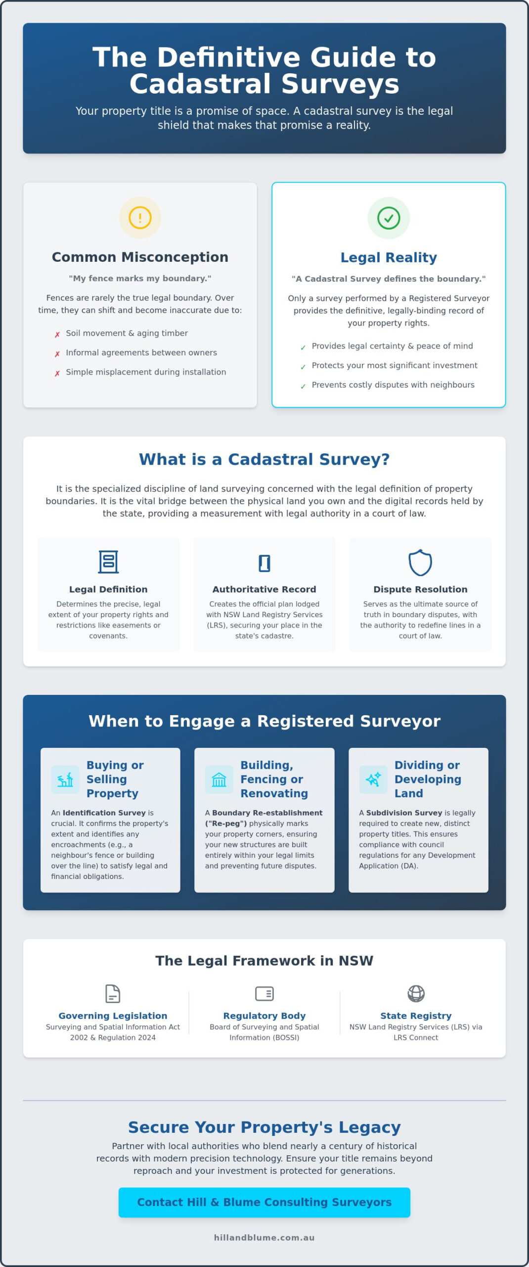
- Realize why a fence is rarely the final word on your land rights and how a professional cadastral survey provides the only definitive legal record of your boundaries.
- Navigate the specific requirements for identification surveys to satisfy legal and financial obligations during your next property transfer.
- Protect your investment by learning to spot the subtle measurement risks that often lead to complex boundary disputes with neighbors.
- Determine exactly when to call for expert set-out or boundary services to ensure your renovations or new fencing projects remain within your legal limits.
- Gain peace of mind by partnering with local authorities who blend nearly a century of historical records with modern precision technology.
What is a Cadastral Survey? Defining Your Property Boundaries
The rhythm of property ownership in New South Wales is dictated by more than just a street address or a familiar fence line. When you invest in land, you’re securing a specific portion of the Earth’s surface, yet the true extent of that investment is often invisible to the naked eye. A cadastral survey is the specialized discipline of land surveying concerned with the determination and legal definition of property boundaries. It’s the vital bridge between the physical terrain you walk upon and the digital records held by the state. While a topographic or site survey might map the contours of your garden, only a cadastral survey carries the legal weight necessary to resolve disputes or facilitate a property transfer.
You may find it surprising that the fences surrounding your home are frequently misplaced. Over decades, soil movement, aging timber, and informal agreements between previous owners can cause physical markers to drift away from their intended positions. The cadastre serves as the state’s comprehensive public record of land ownership, a master map that ensures every parcel of land is accounted for. The practice of Cadastral surveying is the only form of measurement with the legal authority to redefine these lines in a court of law, providing you with the quiet confidence that your property’s legacy is secure.
The Legal Framework in New South Wales
In our region, land rights are anchored by the Surveying and Spatial Information Act 2002 and the more recent Surveying and Spatial Information Regulation 2024. These laws ensure that every cadastral survey performed is accurate, ethical, and standardized. Most Sydney properties operate under the Torrens Title system, a method of land titling where the government guarantees the accuracy of the register. For your boundaries to be legally recognized, a Registered Surveyor must lodge the data with NSW Land Registry Services (LRS). This process is increasingly digital; as of early 2026, all plans must be lodged through the LRS Connect portal, ensuring your property data is part of a modern, efficient system. In NSW, this specialized work is strictly governed by the Board of Surveying and Spatial Information (BOSSI), ensuring only qualified experts handle your land rights.
Beyond Measurements: Rights and Restrictions
Understanding your land involves more than just finding the corners of your lot. A professional survey uncovers the hidden layers of your title, such as easements for services, restrictive covenants, or rights of way that may impact how you enjoy your space. A surveyor doesn’t just pull a tape measure; they interpret historical “metes and bounds” descriptions found in century-old documents to reconstruct the original intent of the land grant. This level of craftsmanship distinguishes a legally binding cadastral plan from a simple site survey. Whether you’re planning a sophisticated extension or simply want to clarify your rights, our specialized surveying services ensure your title remains beyond reproach and your investment is protected for generations to come.
The Anatomy of Cadastral Surveying: Common Types in NSW
The journey of property ownership often leads to moments where you need more than a general map. You need a specific legal instrument that speaks the language of the court and the registry. Depending on whether you’re purchasing a coastal home, dividing a family estate, or developing a boutique apartment complex, the type of survey required will shift to meet your unique aspirations. In New South Wales, these professional acts contribute to the digital representation of all land parcel and property boundaries, ensuring the state’s record remains a source of truth for every resident. This cadastral survey work is what transforms a physical patch of earth into a secure, tradable asset.
Boundary Re-establishment and Identification
A common point of confusion for homeowners is the “missing” corner peg. Over time, landscaping, soil movement, or simple aging can hide the physical markers of your land. Requesting a “re-peg” is a standard part of boundary re-establishment. During this process, a surveyor returns to your site to physically mark the corners defined in your title, providing a tangible guide for your next project. If you’re in the process of buying or selling, your solicitor will likely request an Identification Survey. This report goes beyond simple lines; it identifies potential encroachments, such as a neighbor’s guttering or a misaligned garage, providing the clarity needed for a secure transaction. These meticulous checks are the cornerstone of Boundary Surveys in Sydney, acting as a safeguard for your property’s integrity.
Subdivision and Strata Planning
When your vision involves growth, the land subdivision process becomes your path forward. This work creates entirely new legal identities for land parcels, carving out fresh opportunities from existing estates. In high-density areas, Strata Plan Surveyors perform a delicate dance of defining vertical and horizontal boundaries within a single building. Strata and Community Title plans represent a highly specialized branch of the cadastral survey, essential for defining your private sanctuary versus the common property shared by the community. For developers seeking to balance private ownership with shared lifestyle amenities, a community title subdivision in NSW offers a sophisticated alternative that sits between traditional Torrens and strata title arrangements. This level of detail ensures that every owner understands their rights and responsibilities from the moment the title is registered. If you’re unsure which path fits your current project, speaking with an expert can help clarify the most efficient way to secure your boundaries.
Why Accuracy Matters: Protecting Your Property Legacy
You’ve likely walked the perimeter of your garden, perhaps resting a hand on a weathered timber fence, and felt a sense of absolute ownership. However, in the discerning world of Sydney real estate, a fence is rarely more than a polite suggestion of a boundary. Relying on physical markers rather than legal titles is a common fallacy that can lead to significant complications. A cadastral survey isn’t merely a technical requirement; it’s a sophisticated act of due diligence that preserves the integrity of your property legacy. When dealing with high-value assets in our region, the difference between a secure investment and a costly legal tangle often comes down to a matter of centimeters.
The financial impact of a measurement error can be profound. Building a bespoke extension that inadvertently encroaches upon a neighbor’s land or sits atop a hidden easement can lead to mandatory demolition or expensive compensation. By prioritizing precision, you ensure that every brick laid and every dollar spent adds genuine value to your home. This level of craftsmanship in data collection mirrors the care you’ve put into the property itself, providing a foundation of trust that carries through to future generations.
Mitigating Costly Boundary Disputes
In Sydney’s established suburbs, where heritage charm meets modern luxury, space is at a premium. Encroachment disputes often arise from simple misunderstandings or historical inaccuracies that have gone unnoticed for decades. When tensions climb, a registered surveyor serves as an impartial expert, providing a clear, evidence-based resolution that adheres to the legal framework for Registered Surveyors. Having a current survey in hand before a disagreement escalates is the most effective way to protect your peace of mind. It transforms a potentially heated emotional conflict into a calm, professional conversation rooted in verified facts.
Securing Your Development Approval (DA)
If you’re planning to enhance your lifestyle through a renovation or new build, your local council will require more than just an artistic vision. NSW councils mandate cadastral-backed site plans for Development Applications to ensure your project respects the community’s shared layout. An inaccurate boundary assumption can trigger a “stop-work” order, causing delays that are both frustrating and expensive. Ensuring your contour and detail survey is referenced to the correct legal title is a vital step in this process. By aligning your architectural aspirations with a precise cadastral survey, you create a seamless path from the drawing board to the finished masterpiece, confident that your project stands on solid legal ground.
When to Engage a Registered Surveyor for Cadastral Work
Discerning property owners understand that timing is as critical as precision. Recognizing the exact moment when professional verification is required can save you from years of administrative friction or emotional stress. You don’t always need a surveyor for every garden update, but when your vision involves permanent changes to the land’s structure or its legal status, a cadastral survey becomes your most valuable tool. Whether you’re securing a legacy in the Northern Beaches or navigating a complex transfer in the inner city, knowing these triggers ensures your investment remains beyond reproach.
There are several pivotal moments where engaging a registered expert is non-negotiable:
- Installing new fencing or substantial retaining walls, particularly in established areas where historical records may be aged.
- Purchasing a property where boundary pegs are no longer visible, leaving you uncertain of your true land area.
- Applying for a subdivision or strata title to unlock the potential of a new development.
- Resolving a disagreement with a neighbor regarding land use or perceived encroachments.
Pre-Construction and Renovation Planning
Before the first sketch is drawn, sophisticated architects require high-fidelity cadastral data. They design with an eye for elegance, but they must work within the strict reality of your legal setbacks. By verifying these lines early, you protect your project from the risk of non-compliance. Once your plans are approved, the role of a construction set-out becomes paramount. This service ensures that your builders place every footing and wall exactly where the design intended, maintaining the delicate balance between your new extension and the legal boundary. It’s a layer of craftsmanship that guarantees your build is as legally sound as it is structurally beautiful.
Buying, Selling, and Property Transfers
The settlement process is a time for celebration, yet it’s also a time for absolute clarity. Solicitors often recommend an Identification Survey during a property transfer to act as a definitive “health check” for the land. This cadastral survey reveals hidden issues that a casual walk-through might miss, such as illegal structures or gutters that “overhang” the property line from a neighboring lot. Receiving a certified report provides you with a sense of calm confidence, knowing that the title you’re assuming is clean and well-defined. If you find yourself at one of these property milestones, reach out to our team for a tailored consultation that respects both your time and your property’s unique heritage.
The Hill & Blume Approach: 90 Years of Surveying Heritage
At Hill & Blume, we believe that the most precise future is built upon a deep respect for the past. For over 90 years, our firm has served as a custodian of the New South Wales landscape, blending the traditional integrity of our heritage with the sophisticated precision of modern GNSS and 3D Scanning technology. We recognize that your property is more than a coordinate on a map; it is a sanctuary and a significant investment. Our commitment to a boutique experience means we prioritize quality and meticulous detail over high-volume turnover, ensuring that every cadastral survey we perform is a masterpiece of accuracy.
Our deep archive of historical survey records across Sydney and Newcastle provides a unique advantage that digital databases alone cannot replicate. When you require a survey for a property with a storied history, this local expertise becomes essential for interpreting the nuances of complex NSW land titles. We don’t just provide data; we provide a narrative of ownership that has been carefully preserved through decades of specialized service. This depth of relationship with the local culture and terrain allows us to offer a level of insight that remains anchored by traditional integrity and a personal touch. For those considering how to unlock the full potential of their land, understanding the land subdivision process in NSW is an essential step toward making informed, confident decisions about your property’s future.
The Importance of Being a Registered Surveyor
The path to becoming a Registered Surveyor in New South Wales is marked by rigorous training and an unwavering commitment to the ethical standards set by the Board of Surveying and Spatial Information (BOSSI). This registration is far more than a professional title; it is a legal mandate. In our state, only a Registered Surveyor possesses the legal authority to prepare and sign off on cadastral plans for lodgment. This ensures that the person defining your land rights is held to the highest level of accountability and expertise. You can explore our full range of professional surveying services to see how this specialized knowledge protects your property interests.
Navigating the Sydney Landscape
Consider the intricate boundaries of Sydney’s inner suburbs, where heritage terraces often share walls and historical discrepancies are common. In these challenging environments, we frequently resolve complex boundary issues that have remained dormant for generations, using our historical records to find clarity where others might find only confusion. Our presence extends across Sydney, Newcastle, and the Central Coast, positioning our team as an essential part of the local fabric. Hill & Blume stands as a seal of quality and a curated experience in the NSW surveying industry, ensuring your property journey is handled with a boutique, hand-crafted touch that respects both your time and your intelligence.
Securing Your Property’s Future with Precision
Your property is a testament to your hard work and a cornerstone of your unique lifestyle. Understanding that a fence is merely a physical marker while a cadastral survey is your definitive legal shield is the first step toward true property security. You now recognize that whether you’re planning a sophisticated renovation in Sydney or a new subdivision in NSW guided by a professional roadmap, precision is the only currency that matters in the eyes of the law. This clarity ensures your rights are protected and your investment remains beyond reproach.
With over 90 years of heritage, Hill & Blume brings a refined, boutique approach to every parcel of land we measure. Our team of Registered Surveyors remains strictly compliant with BOSSI standards, ensuring your project meets every regulatory requirement with effortless grace. We invite you to secure your property boundaries with a consultation from Hill & Blume. From the vibrant streets of Sydney to the coastal reaches of the Central Coast, we’re here to provide the calm confidence you deserve. Let’s ensure your investment remains protected for generations to come.
Frequently Asked Questions
What is the difference between a land survey and a cadastral survey?
A land survey is a broad term that encompasses many types of spatial measurement, but a cadastral survey is the only type specifically concerned with legal property boundaries. While other surveys might map the contours of your garden or the height of a building, the cadastral version defines your legal land rights and secures your title. It’s the essential link between the physical earth and the state’s land registry.
Who is legally allowed to perform a cadastral survey in NSW?
Only a Registered Surveyor is legally authorized to perform a cadastral survey in New South Wales. These professionals are formally recognized by the Board of Surveying and Spatial Information (BOSSI) after years of rigorous training and examination. Engaging an unregistered individual for boundary work is not only risky but lacks any legal standing in the event of a dispute or property transfer.
How much does a cadastral boundary survey cost in Sydney?
The investment for a cadastral survey in Sydney depends on the complexity of your property’s terrain and the clarity of existing historical records. Because every lot in our region has a unique heritage, costs are tailored to the specific research and fieldwork required to define your boundaries with absolute precision. You’ll find that the peace of mind provided by a certified report far outweighs the initial expense.
Will a cadastral survey help me resolve a dispute with my neighbour?
Yes, a cadastral survey is the most effective tool for resolving boundary disagreements by replacing emotional tension with verified legal facts. By uncovering the definitive property lines as recorded in the state’s register, a Registered Surveyor provides an impartial, evidence-based resolution. This professional clarity often prevents minor misunderstandings from escalating into expensive and exhausting legal battles.
How long does it take to complete a cadastral survey for a standard lot?
Completing a cadastral survey for a standard lot usually involves a few days of fieldwork followed by a period of meticulous historical research and plan preparation. While the physical measurements are taken relatively quickly, the time spent cross-referencing your property with century-old land grants and digital records ensures the final result is beyond reproach. This thorough process guarantees that your boundaries are legally sound.
Do I need a cadastral survey for a new fence in NSW?
Obtaining a cadastral survey before installing a new fence is highly recommended to ensure your investment sits exactly on the legal boundary. Fences are often misplaced over time, and relying on an old fence line can lead to accidental encroachments on your neighbor’s land. Starting with a precise survey ensures your project is compliant and avoids the significant cost of relocating a misaligned structure.
What is the Board of Surveying and Spatial Information (BOSSI)?
The Board of Surveying and Spatial Information (BOSSI) is the regulatory body that oversees the surveying profession in New South Wales. They are responsible for the registration of surveyors and for maintaining the high standards of competency and ethical conduct required for cadastral work. BOSSI ensures that the integrity of the state’s land title system remains protected through the rigorous vetting of every Registered Surveyor.
How often should a cadastral survey be updated for a property?
You don’t need to update your survey on a fixed schedule, but a new cadastral survey is essential if your boundary pegs are missing or if you’re planning a major development. It’s also wise to commission a fresh survey if you’re purchasing an older property where the boundaries haven’t been verified for decades. Keeping your records current ensures that your land use always reflects the most accurate legal data.
Disclaimer
The information provided in articles published on this website is for general informational purposes only. While we make every effort to ensure the accuracy, completeness, and timeliness of the content, the material is based on our understanding of the industry at the time of writing and may not reflect the most current developments, regulations, or standards. All opinions expressed in our articles are those of the respective authors and do not necessarily represent the official position of the website or its affiliates. The content should not be considered professional, legal or technical advice, and should not be relied upon as a substitute for consultation with qualified professionals