

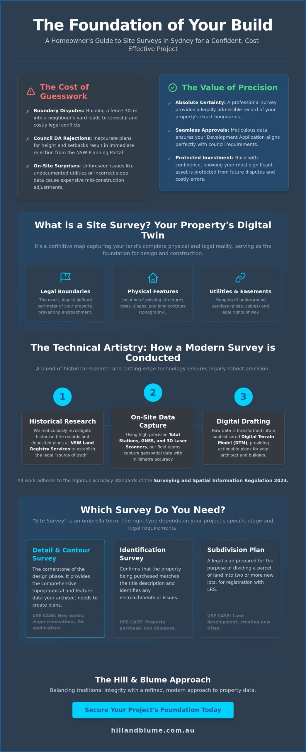
Imagine the quiet, sinking feeling of discovering your new boundary fence sits thirty centimetres into your neighbour’s yard just as the final landscaping is completed. It is a costly and deeply stressful realization that often stems from a simple lack of precision at the very start of a project. Whether you are planning a heritage renovation in Paddington or a contemporary build overlooking the harbour, your vision deserves a foundation built on absolute certainty. Securing a professional site survey is the essential first step in transforming that vision into a tangible, protected reality that respects both the land and your investment.
You likely understand that the Sydney planning landscape feels increasingly complex, particularly with the rigorous standards of the Surveying and Spatial Information Regulation 2024. It is natural to feel a sense of anxiety over potential Council DA rejections or the intricate requirements of the NSW Planning Portal. We believe that your property journey should be defined by calm confidence and a partnership oriented toward excellence. This guide provides a clear roadmap for your pre-construction phase, ensuring your project is anchored by accurate legal and physical data. We will explore how professional precision creates a seamless integration between your architect, the council, and your future home.
Key Takeaways
- Understand how a comprehensive map of your property’s physical and legal features serves as the indispensable foundation for any successful Sydney build.
- Explore how modern precision tools, including GNSS and 3D laser scanning, safeguard your investment by eliminating the risk of costly boundary disputes.
- Learn to distinguish between project-specific requirements to ensure you commission the correct site survey, whether you are seeking design detail or legal boundary certainty.
- Master the nuances of the NSW Planning Portal to ensure your Development Application aligns perfectly with council requirements for height and setbacks.
- Discover the benefits of engaging a specialized local authority that balances traditional integrity with a refined, modern approach to property data.
What is a Site Survey? Defining the Foundation of Your Project
You wouldn’t build a home on a foundation of guesswork. In the context of Sydney’s unique landscape, a site survey is the definitive map of your land’s physical and legal reality. It captures everything from the subtle slope of a garden to the exact location of underground utilities and existing structures. For any significant architectural project in our city, this document isn’t just helpful; it’s a mandatory requirement that ensures your design respects both the law and the land.
Think of it as a digital twin of your property. Before a single brick is laid, this precise data set allows your project team to visualize every constraint and opportunity. It ensures that the vision you’ve curated aligns perfectly with the physical boundaries of your site. By documenting official boundary alignments alongside topographical features, a professional surveyor provides the clarity needed to move from a dream to a buildable plan.
Why ‘Site Survey’ is an Umbrella Term
When you hear the term site survey, it often refers to a Detail and Contour Survey, which is the cornerstone of the design phase. This differs significantly from a simple real estate plan or a visual inspection. A professional survey is a legally admissible document prepared by a Registered Surveyor. It provides the technical depth required for Construction surveying, ensuring that every measurement is accurate to the millimetre. You can explore our range of specialized surveying services to see which specific plan fits your current project stage. Whether you need an identification report for a purchase or a subdivision plan for a new development, the specific type of survey you choose must match your project’s legal requirements.
The Cost of Skipping a Professional Survey
In Sydney’s high-density suburbs, the margins for error are incredibly slim. Encroaching on a neighbour’s boundary by even a few centimetres can lead to bitter disputes or expensive legal delays. Without accurate data, you’ll likely face costly on-site adjustments during the build. These surprises often cost far more than the initial investment in a professional survey. Protecting your most significant financial asset starts with the peace of mind that comes from knowing exactly where your property begins and ends. It’s about building with confidence from day one. By securing a precise record of your land, you create a seamless path through council approvals and ensure your investment remains protected for decades to come.
The Technical Artistry: How Modern Site Surveys are Conducted
A professional site survey is a delicate dance between historical truth and modern innovation. While the core principles of land measurement have remained constant for centuries, the tools we use to capture that data have evolved into a sophisticated suite of digital technologies. This process doesn’t begin on your property; it starts within the deep archives of NSW Land Registry Services. Here, we meticulously research historical title records and deposited plans to understand the legal “source of truth” for your land before a single tripod is levelled on-site.
Once the historical context is established, our field teams arrive equipped with high-precision instruments. We utilize Total Stations and Global Navigation Satellite Systems (GNSS) to capture geospatial data with absolute certainty. For more intricate projects, 3D laser scanning allows us to create a dense cloud of data points, capturing the exact texture and form of existing structures. As of 2026, all our work adheres to the rigorous accuracy tolerances defined in the Surveying and Spatial Information Regulation 2024, which commenced on March 1, 2025. These NSW surveying regulations ensure that the data we provide is not only precise but legally robust.
From Fieldwork to Digital Drafting
The raw data collected in the field is a collection of coordinates that we transform into a sophisticated Digital Terrain Model (DTM). This model is essential for your project team, as it allows for the precise calculation of excavation volumes and ensures your architectural vision fits the natural contours of the land. We then craft a comprehensive CAD file that includes every tree, manhole, and ridge line with millimetre precision. This digital blueprint becomes the primary reference for your architect, ensuring their designs are grounded in reality. A topographic survey in Sydney is the essential tool that captures these precise ground-level details, translating raw field data into a design-ready foundation your entire project team can rely on. You can view our full range of specialized surveying services to see how this data supports different project stages.
The Human Element: The Registered Surveyor’s Expertise
While technology provides the data, only a Registered Surveyor possesses the legal authority in NSW to define a property boundary. This role requires a blend of technical mastery and investigative skill. We often find ourselves re-establishing boundaries based on “marks” that may be decades old, requiring a deep understanding of Sydney’s unique cadastral history. It’s a meticulous process of reconciliation, ensuring that new measurements align perfectly with the original intent of the land title. At Hill & Blume, we integrate over 90 years of local knowledge into every project, providing a level of discernment that a machine simply cannot replicate. If you’re ready to secure the foundation of your next project, we invite you to start a conversation with our team today.
Which Survey Do You Need? A Comparison for Sydney Homeowners
Choosing the right site survey is ultimately a matter of alignment. It’s about matching the technical depth of the data to the specific needs of your project stage. While a broad overview might suggest all surveys are similar, the reality is that each type serves a distinct purpose in the Sydney property lifecycle. Site surveys are detailed studies that act as the eyes of your design team, providing the precision needed to navigate both physical and regulatory landscapes. By understanding the nuances of each, you can ensure your project moves forward with clarity and legal protection.
Not all surveys are created equal. The document you need for a bank valuation is vastly different from the one your architect requires to design a multi-level renovation. We view each survey as a bespoke tool, crafted to solve a specific set of challenges. Whether you are at the beginning of your journey or nearing the final handover, selecting the correct survey type is the first step toward a seamless experience.
Detail and Contour: The Architect’s Best Friend
Your architect needs more than a simple outline; they require a three-dimensional understanding of your land’s topography and the structures that surround it. A Contour and Detail Survey: The Essential Foundation is the architect’s most trusted tool. It meticulously documents floor levels, roof heights, and even the exact placement of neighbouring windows. In Sydney, where privacy and solar access are paramount, this data is vital for passing council impact assessments. It ensures your design is sensitive to its surroundings while maximizing the unique potential of your site. This site survey provides the canvas upon which your vision is painted, capturing every nuance of the terrain. For projects where the natural landscape plays a defining role, commissioning a detailed topographic survey in Sydney ensures that every slope, ridge, and elevation change is precisely mapped before your architect commits to a single design decision.
Boundary and Identification: Legal Safeguards
Legal certainty is the bedrock of property ownership. Whether you are settling a boundary dispute or planning a new perimeter fence, a Boundary Survey provides the definitive answer to where your land begins and ends. For those navigating the vibrant markets of Crows Nest or the Northern Beaches, an Identification Survey is frequently required for property transactions and bank valuations. It provides a legal safeguard, ensuring that your investment is sound and that your future construction remains strictly within your legal title. This level of protection is essential to prevent costly encroachments that could haunt a project for years. Finally, as your build concludes, a Work-as-Executed (WAE) survey verifies that the physical structure matches the approved plans, providing a seamless conclusion to the construction phase.
Navigating the NSW Planning Process with a Site Survey
Your project’s journey through the planning system requires a technical passport that speaks the language of authority. In the context of Sydney’s rigorous development standards, a site survey is that essential document. It translates your architectural vision into the precise geospatial data required by the NSW Planning Portal. Whether you’re pursuing a Development Application (DA) or a Complying Development Certificate (CDC), your submission starts here. Every council across our city relies on this data to assess critical constraints, including building height limits, floor space ratios, and essential setbacks from your boundaries.
Accuracy isn’t just a preference; it’s a regulatory necessity. Your survey must strictly adhere to the practice directives established by the NSW Surveyor-General and the Surveying and Spatial Information Regulation 2024. When a plan is prepared with this level of professional rigour, it significantly reduces the likelihood of “Requests for Information” (RFIs) from council planners. These requests often cause frustrating delays in the approval process. By providing a compliant and detailed survey from the outset, you pave the way for a smoother, more predictable path toward your construction start date.
Meeting Sydney Council Requirements
Sydney’s inner suburbs and coastal fringes present unique challenges that demand a discerning approach. If you’re renovating a heritage-listed terrace in Paddington or Balmain, your site survey must capture intricate details that allow planners to assess the impact on the historical streetscape. Beyond the aesthetic, we provide the foundational data for Biodiversity and Bushfire Attack Level (BAL) assessments, which are increasingly critical in our changing environment. For properties in flood-prone areas or near the harbour, we establish the Australian Height Datum (AHD). This standardized elevation data is the only reliable way for council to assess flood risk and ensure your new floor levels are safely positioned above the required flood planning levels.
The Role of the Surveyor in the DA Lifecycle
We view the surveyor as a vital consultant who remains tethered to your project from conception to completion. We provide the essential base plan that serves as the “single source of truth” for your entire design team, including architects, structural engineers, and landscape designers. Once your plans are approved, the focus shifts to physical execution. This is the moment where a Construction Set-out becomes the most important document on your site. It ensures that your builders place the footings and walls with millimetre precision, matching the approved DA exactly. This level of care protects you from the nightmare of non-compliance after the concrete has been poured. If you’re ready to navigate the complexities of the Sydney planning system with a partner you can trust, we invite you to reach out to our specialist team for a tailored consultation.
The Hill & Blume Approach: Precision Rooted in Heritage
Founded in 1932, Hill & Blume offers a legacy of accuracy that has matured alongside Sydney’s own architectural evolution. We specialize in high-end residential and complex commercial projects, where the demand for precision is matched only by the value of the property itself. Our boutique approach ensures you aren’t just another project number in a clinical system. You receive a bespoke service that prioritizes the depth of our relationship and the specific needs of your land. This commitment to quality acts as a seal of trust for architects and builders across NSW, providing them with the certainty they need to create without hesitation.
A professional site survey from our team is more than a technical drawing; it’s a hand-crafted record of your property’s potential. We believe that quality should always take precedence over quantity, a philosophy that has anchored our practice for over 90 years. Every measurement we take is a promise of reliability, ensuring that your investment is protected by data that stands up to the closest scrutiny.
Why 90 Years of Experience Matters Today
Accessing an unparalleled archive of historical survey data allows us to see what others might overlook. In a city like Sydney, where property lines often trace back to the early 19th century, this historical context is vital. Our deep relationships with local councils, stretching from Newcastle to the Central Coast, ensure that we understand the specific local fabric of every area we work in. We pride ourselves on solving complex boundary puzzles that newer firms might find insurmountable. This ensures your project remains grounded in traditional integrity while meeting the modern standards of the Surveying and Spatial Information Regulation 2024.
Your Next Steps for a Seamless Project
Embarking on your project with confidence starts with a tailored quote for your specific site needs. Before our surveyor arrives, it’s helpful to ensure that all areas of your property are accessible and any existing plans are ready for review. This preparation allows us to provide the most efficient and thorough service possible. We invite you to explore our full range of Professional Land Surveying Services to discover how we can support your vision. Whether you require a boundary survey or a precise construction set-out, we provide the calm confidence you need to build beautifully. Our goal is to provide a seamless integration between your aspirations and the physical reality of your land, ensuring your build is as effortless as it is exquisite.
Building Your Vision on a Foundation of Certainty
Your property project is a profound expression of your lifestyle and a significant investment in your future. We’ve explored how a professional site survey acts as the essential “source of truth,” shielding you from the stress of boundary disputes and ensuring your designs align perfectly with the latest 2024 NSW regulations. By choosing the correct survey type, you streamline the path through the planning portal and into the physical build.
As you transition from technical planning to the physical build, considering how to maximize your outdoor living areas is a natural next step. You can learn more about Aussie Zip Blinds to see how premium, Australian-made outdoor blinds can enhance the comfort and privacy of your new property.
Hill & Blume brings over 90 years of Sydney surveying heritage to your project. As Registered NSW Surveyors, we specialize in Detail and Contour surveys for high-end developments, providing the technical artistry and boutique care your vision demands. We invite you to secure the precision your project deserves and contact Hill & Blume for a site survey today. Let’s ensure your project is built on data that is as enduring and refined as the home you’re creating.
Frequently Asked Questions
What is included in a standard site survey?
A standard survey includes a precise mapping of your property’s boundaries, ground levels, and all significant existing structures. We also document essential features such as large trees, visible utility access points, and any easements that might impact your design. This detailed record provides the clarity your architect needs to create a vision that is both beautiful and buildable within the physical constraints of your land.
How much does a site survey cost in Sydney in 2026?
The investment required for a professional survey is determined by the specific requirements and physical complexity of your unique property. Factors such as steep terrain, heavy vegetation, or the need for extensive historical title research will influence the final quote. We offer tailored proposals that reflect the bespoke nature of your project, ensuring you receive a premium service that prioritizes accuracy and long term value over high volume turnover.
How long does it take to complete a site survey and receive the plans?
The timeline for receiving your completed plans is usually between one and two weeks following the initial site visit. This period allows our Registered Surveyors to meticulously process the field data and cross-reference it with historical records from NSW Land Registry Services. We prioritize a deliberate pace that ensures every millimetre is accounted for, providing you with a document that mirrors the seamless service we aim to provide.
Do I need a site survey if I already have the original house plans?
Yes, you need a contemporary site survey because original house plans often fail to reflect current legal boundaries or physical changes to the terrain. Over time, fences may have shifted and new structures might have been added that aren’t documented in old architectural drawings. A fresh survey provides a verified “source of truth” that protects you from modern regulatory hurdles and ensures your project is built on accurate data.
Can a site survey help resolve a fence dispute with my neighbour?
Yes, a professional survey is the most effective way to resolve a fence dispute by providing an impartial and legally admissible record of your boundary. By physically marking the legal title lines on the ground, a Registered Surveyor offers the clarity needed to settle disagreements with confidence. This authoritative approach often prevents minor misunderstandings from escalating, fostering a sense of calm and mutual respect between you and your neighbours.
What is the difference between a site survey and a land survey?
A site survey is typically a focused study of a specific property for design or construction purposes, whereas a land survey is a broader industry term. While both involve precise measurement, a site-specific plan captures the intricate nuances of your land’s topography and existing features. In a residential context, you are likely seeking this detailed mapping to ensure your architectural vision integrates perfectly with the local Sydney landscape.
How long is a site survey report valid for in NSW?
While survey reports don’t have a legal expiration, they are generally considered current for approximately two years by most Sydney councils. Over time, physical changes or new regulations like the Surveying and Spatial Information Regulation 2024 may necessitate an update. Ensuring your data is recent protects you from planning delays and ensures your project is based on the most accurate and legally robust geospatial information available today.
Do I need to be home when the surveyor visits my property?
You aren’t required to be present during the field visit as long as our team has unobstructed access to your entire property. We simply ask that pets are secured and any locked gates are opened before our arrival to ensure a smooth workflow. However, if there are specific features or hidden details you wish to discuss, we welcome a brief conversation to ensure our partnership begins with a shared understanding.
Disclaimer
The information provided in articles published on this website is for general informational purposes only. While we make every effort to ensure the accuracy, completeness, and timeliness of the content, the material is based on our understanding of the industry at the time of writing and may not reflect the most current developments, regulations, or standards. All opinions expressed in our articles are those of the respective authors and do not necessarily represent the official position of the website or its affiliates. The content should not be considered professional, legal or technical advice, and should not be relied upon as a substitute for consultation with qualified professionals