

A bespoke architectural vision for your Sydney home is only as secure as the invisible data beneath its foundations. You likely understand that building in a city as geographically diverse as ours requires more than just a beautiful facade; it demands a seamless navigation of local council regulations and site-specific challenges. When you commission a precise contour and detail survey, you aren’t simply purchasing a technical map. You’re securing the integrity of your entire project and ensuring that your creative vision is anchored in reality.
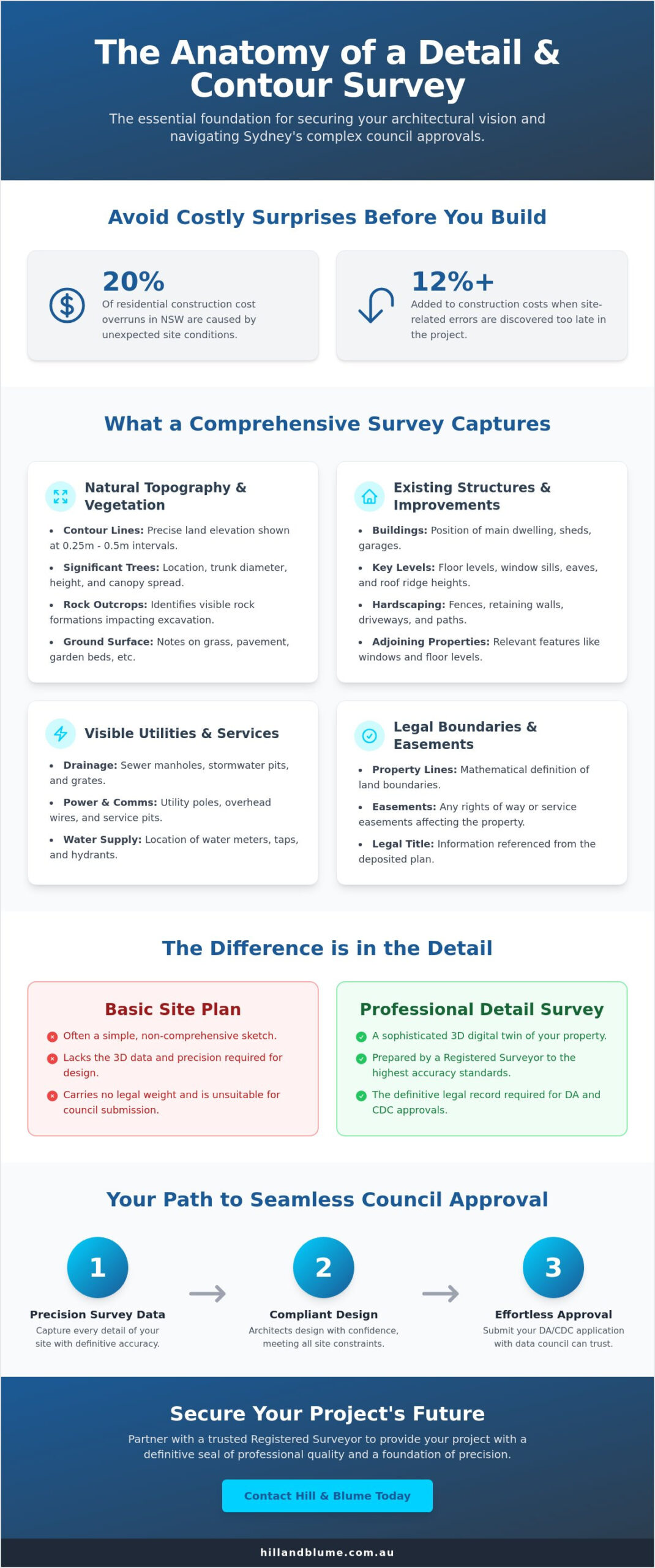
We recognize the anxiety that often accompanies a new development, from the confusion over different survey types to the fear of hidden costs surfacing once construction begins. Recent industry analysis indicates that unexpected site conditions contribute to 20% of residential construction cost overruns in New South Wales. This guide offers a clear, curated path through the survey process. You’ll discover how accurate data serves as the essential foundation for your architect, ensuring your site plan is fully compliant and your path to council approval remains effortless.
Key Takeaways
-
Understand how a bespoke three-dimensional representation of your land provides the essential clarity needed to translate your architectural vision into reality.
-
Explore the critical features a high-quality contour and detail survey must include to capture the unique character and existing infrastructure of your Sydney property.
-
Discover how accurate data simplifies the journey toward DA and CDC approvals, ensuring your project meets strict council requirements with seamless ease.
-
Learn to distinguish between different survey types to protect your investment and maintain the technical integrity of your development from the very first measurement.
-
Partner with a trusted local expert to secure a foundation of precision and heritage, providing your project with a definitive seal of professional quality.
Table of Contents
-
The Anatomy of a Comprehensive Detail Survey: What’s Captured?
-
Navigating the Confusion: Contour Surveys vs. Identification Surveys
-
The Road to Approval: How Surveys Facilitate Sydney DA and CDC
-
Securing Your Project’s Future with a Registered Sydney Surveyor
What is a Contour and Detail Survey in the Sydney Context?
When you begin a property journey in Sydney, you aren’t just looking at a plot of land. You’re looking at a complex landscape with its own unique story. A contour and detail survey provides a sophisticated three-dimensional representation of your property, capturing the precise intersection of natural topography and man-made structures. It’s the digital twin of your site, mapping every significant feature from the height of the roof ridges to the exact location of a backyard sewer manhole.
Sydney’s geography demands this level of precision. Our city is built on a diverse canvas of steep, sloping blocks overlooking Middle Harbour and ancient rocky outcrops in the Inner West. These variations aren’t just aesthetic; they dictate what you can build and where you can build it. At Hill & Blume, we view land measurement through the lens of integrity. This isn’t just about plotting points on a grid. It’s about a commitment to accuracy that serves as the pillar of our partnership with you, ensuring your vision is built on a foundation of truth.
The output of this work is essentially a highly detailed topographic map. By using contour lines to represent the rise and fall of the earth, the survey allows your design team to see the land’s hidden challenges before the first shovel hits the dirt. It’s a curated data set that respects the reality of the Sydney terrain.
The Foundation of Every Successful Sydney Development
This survey is the non-negotiable first step for any high-end renovation or new build. You wouldn’t build a dream on a guess, and accurate data prevents the heartbreak of costly redesigns late in the project lifecycle. Industry data suggests that site-related errors can add 12% or more to construction costs when discovered too late. By identifying site constraints like hidden easements or significant trees early, you ensure a seamless transition from initial concept to council approval.
Why a Basic Site Plan Falls Short
A basic site plan is often a simple sketch that lacks the depth required for a sophisticated build. In contrast, a professional contour and detail survey carries significant legal weight. It’s prepared by a registered land surveyor and acts as a definitive record of your land’s boundaries and features. Our bespoke data collection caters to your architect’s specific requirements. We ensure every window height, floor level, and boundary offset is perfectly aligned with your project’s unique requirements, providing a level of care that a standard plan simply cannot match.
The Anatomy of a Comprehensive Detail Survey: What’s Captured?
Precision is the silent partner of great design. A high-quality contour and detail survey acts as the definitive source of truth for your project, transforming a physical plot of land into a sophisticated digital canvas. It’s a bespoke collection of data points that allows architects and engineers to work with absolute confidence. This isn’t merely a map; it’s a curated narrative of your property’s possibilities and its constraints.
The data provided is meticulously filtered to ensure every stakeholder has what they need. While an architect might focus on the elegant curve of a sandstone outcrop, an engineer looks at the technical levels of a sewer manhole. By capturing the interplay between the natural environment and existing infrastructure, the survey ensures your vision remains grounded in reality. This level of detail is what separates a seamless build from a project plagued by unforeseen site costs.
Natural Topography and Vegetation
The rhythm of the land is dictated by its topography. A comprehensive contour and detail survey illustrates the rise and fall of your site through precise contour lines, typically measured at 0.25-metre or 0.5-metre intervals. This data is vital for managing stormwater runoff and determining how a building will sit within the landscape. In Sydney’s Northern Beaches or the Eastern Suburbs, these surveys often document significant rock outcrops that can influence excavation costs and foundation designs.
Vegetation is another critical layer of the survey. We identify significant trees, recording their exact location, trunk diameter, and canopy spread. This information is non-negotiable for council compliance, as many Sydney local government areas have strict Tree Preservation Orders. Having this data early allows you to design around protected species, ensuring a smoother path through the DA process.
Man-Made Structures and Invisible Utilities
Your property doesn’t exist in a vacuum. A professional survey maps the footprint of existing buildings, including floor levels, roof ridges, and eave heights. We also locate boundary fences and retaining walls, which are often the source of site complexities. Crucially, we identify the position of neighbouring property windows and balconies. This helps your design team address privacy concerns and overshadowing issues before they become objections during the planning stage.
The most important features are often the ones you cannot see. We integrate data from utility providers to map underground services, including sewer mains, water connections, and telecommunications. Verifying these local NSW utility markings prevents costly strikes during construction and informs where your new connections should be placed. If you’re ready to define the boundaries of your next project, our bespoke approach ensures every detail is captured with integrity.
Every data point serves a purpose. From the height of a kerb to the depth of a drainage pipe, these details form the bedrock of your development. By investing in a high-accuracy contour and detail survey, you’re not just buying a document; you’re securing the technical foundation of your future home.
Navigating the Confusion: Contour Surveys vs. Identification Surveys
Many property owners assume a land survey is a singular, uniform document. This misconception often leads to avoidable delays when a project requires specific data for different stakeholders. While both are essential, a contour and detail survey serves your architect’s vision, while an identification survey protects your legal interests. Understanding this distinction is the first step toward a seamless development journey in Sydney. For a deeper understanding of how different survey types compare, our comprehensive guide on feature survey vs. contour survey differences for Sydney property projects clarifies exactly which document your project requires.
These two documents aren’t competing choices; they’re partners in your project’s success. One provides the creative canvas, while the other defines the legal frame. Engaging a registered surveyor ensures that every measurement carries the weight of professional integrity, protecting you from future boundary disputes or costly design errors.
When a Contour Survey is the Priority
Architects begin their work with the landscape. A contour and detail survey provides the topographical data needed to define your building’s footprint with absolute precision. It maps the subtle rises and falls of your land, allowing your design team to calculate excavation volumes accurately. This data ensures your vision respects the natural terrain and meets Council requirements for height limits and drainage. For a deeper look at protecting your property lines, explore our guide on Boundary Surveys in Sydney.
The Role of the Identification Survey
An Identification Survey, often called an "ID Survey," functions as a legal verification of your property. It confirms the exact location of boundary lines and identifies any encroachments, such as a neighbor’s retaining wall or fence overstepping the mark. Lenders and solicitors typically require this document during the financing stage to ensure the asset is secure. A Hill & Blume identification report offers the peace of mind that comes from a bespoke, meticulous approach to property integrity. It’s about certainty, ensuring your investment remains protected by the law.
To ensure your project starts on firm ground, consider how these surveys overlap:
-
Design Accuracy: The detail survey captures existing structures, trees, and utility services.
-
Legal Security: The ID survey marks the physical boundaries where your rights begin and end.
-
Seamless Approval: Most Sydney Councils require both data sets to process a Development Application (DA) or Complying Development Certificate (CDC).
You don’t need to navigate these technicalities alone. By choosing a partner who values quality over volume, you ensure your project is built on a foundation of accuracy. Whether you’re planning a sophisticated renovation or a new build, the Hill & Blume name acts as a seal of quality, providing a curated experience that respects your time and your vision.
The Road to Approval: How Surveys Facilitate Sydney DA and CDC
The journey from a vision to a physical structure relies on the precision of your initial data. In Sydney, the planning landscape is governed by the Environmental Planning and Assessment Act 1979. Whether you pursue a Development Application (DA) through your local council or a Complying Development Certificate (CDC) via a private certifier, your contour and detail survey serves as the legal foundation. Hill & Blume provides the technical integrity required to ensure your project moves through these regulatory gates without friction.
We treat every survey as a partnership. We’ve spent years refining our process to ensure your documentation isn’t just accurate, but presented in a way that planning officers trust. This clarity reduces the risk of ‘Requests for Further Information’ (RFIs) that can delay your start date by weeks or even months. We frame our work as a tool for seamless navigation through NSW planning regulations, giving you the confidence to move forward with your vision.
The CDC pathway is particularly demanding. Under the State Environmental Planning Policy (Exempt and Complying Development Codes) 2008, there’s no room for error. A private certifier cannot exercise discretion like a council officer might. If a boundary offset or a height level is off by a few centimeters, the certificate can’t be issued. Our role is to provide the certainty that certifiers require. By delivering a survey that maps every significant tree, existing structure, and utility connection, we remove the guesswork from the approval process. Once your approvals are secured, engaging a dedicated construction set out surveyor in Sydney ensures your approved plans are translated to the ground with millimetre-level accuracy, preventing costly boundary disputes before they arise.
Meeting Local Council Requirements
Sydney councils maintain rigorous standards for new developments. You’ll likely require shadow diagrams to demonstrate your design respects a neighbor’s sunlight. Our surveys provide the precise data needed for these studies and streetscape elevations. Furthermore, larger projects may require a traffic impact assessment for development application to address potential transport and access concerns. Accurate levels prevent disputes over building height limits, while our Work-as-Executed (WAE) surveys ensure you secure your final Occupation Certificate without administrative hurdles. If your long-term vision extends to dividing your land, our expertise in subdivision surveys in Sydney can help you unlock the full potential of your property.
Ready to experience a more refined approach to property development? Partner with Hill & Blume to secure your project’s foundation.
Securing Your Project’s Future with a Registered Sydney Surveyor
Choosing a surveyor is more than a box-ticking exercise; it’s a commitment to your project’s longevity and legal standing. A high-quality contour and detail survey serves as the definitive blueprint for every architect, engineer, and builder involved in your vision. When you select a partner with deep local roots, you’re investing in a seal of quality that resonates through every stage of construction. Hill & Blume brings a refined perspective to land measurement, ensuring that your development is built on a foundation of absolute certainty and sophisticated care.
The Importance of a Registered Land Surveyor in NSW
In New South Wales, the title of ‘Registered Surveyor’ is protected by law under the Surveying and Spatial Information Act 2002. This designation requires years of rigorous university training and a formal commitment to professional integrity. Only a Registered Surveyor has the legal authority to define property boundaries or perform work that impacts land titles. Engaging an unlicensed ‘site measurer’ for a complex Sydney project introduces unnecessary risk. Without the oversight of a registered professional, small errors in a contour and detail survey can lead to costly boundary disputes or council rejections that stall your progress for months. Our registration is your guarantee that the data we provide is legally robust and technically flawless. To make a fully informed decision, our professional guide to choosing a surveyor in Sydney outlines exactly what credentials and qualities to look for when selecting your expert partner.
The Hill & Blume Legacy: Precision Since 1932
Our firm has been an integral part of the Sydney landscape for over 90 years. Since opening our doors in 1932, we’ve focused on a bespoke approach that prioritizes depth of relationship over high-volume turnover. We understand that your property is a significant investment, often representing a lifelong ambition. By combining traditional integrity with modern advancements like drone surveying and high-precision scanning, we provide a curated experience that is both technologically advanced and personally grounded. This blend of history and innovation ensures your project begins with a seamless, accurate data set that respects the unique character of your land.
We invite you to move beyond clinical measurements and experience a partnership-oriented approach to land development. A bespoke survey doesn’t just map the physical terrain; it protects your future by preventing the friction of boundary overlaps or structural misalignments. It’s a considered conversation about your property’s potential. To begin your development journey with confidence, Contact Hill & Blume for a bespoke survey quote and secure the expert guidance your project deserves.
-
Legal Protection: Ensure all boundary work complies with NSW legislation.
-
Legacy of Excellence: Benefit from over nine decades of local Sydney expertise.
-
Modern Technology: Utilize drone and 3D data for unparalleled project clarity.
-
Bespoke Service: Experience a curated, relationship-driven approach to surveying.
Laying a Precise Foundation for Your Sydney Vision
Your vision for a refined Sydney residence deserves a foundation built on absolute precision. Navigating the complexities of DA and CDC approvals requires more than just data; it requires a partnership with experts who understand the nuances of the local landscape. By choosing a comprehensive contour and detail survey, you’re not just mapping land. You’re ensuring your architectural design is grounded in reality, protecting your investment from the earliest stages of development.
At Hill & Blume, we bring over 90 years of Sydney surveying expertise to every high-end residential project we touch. Our team of Registered NSW Land Surveyors provides a bespoke approach that balances technical mastery with a deep appreciation for curated property design. We believe that quality is never an accident. It’s the result of meticulous care and a commitment to seamless service that respects your intelligence and your time.
Let’s begin the journey of bringing your property vision to life with the clarity it deserves. Request a bespoke survey quote from Hill & Blume today to secure the future of your project. Your dream home starts with the right perspective.
Frequently Asked Questions
What is a contour and detail survey?
A contour and detail survey is a comprehensive map of your land that captures both the physical features and the elevation changes of the site. It identifies existing structures, trees, utility services, and the precise slope of the ground. This document serves as the essential blueprint for architects and engineers, ensuring your design respects the natural landscape while meeting Sydney’s strict planning requirements.
How much does a contour survey cost in Sydney?
While every project is unique, a standard residential survey in Sydney typically ranges from A$3,000 according to 2024 industry benchmarks. Factors such as the size of your lot, the density of vegetation, and the complexity of existing structures influence the final investment. We provide a bespoke quote for every client to ensure you receive a service tailored specifically to your site’s unique characteristics and your development goals.
Do I need a registered surveyor for a detail survey?
Yes, you must engage a registered land surveyor for any survey intended for a Development Application or Complying Development Certificate in New South Wales. Only a surveyor registered with the Board of Surveying and Spatial Information can legally certify the accuracy of boundaries and levels. This certification protects your integrity as a developer and ensures that your project stands on a foundation of legal certainty.
How long does it take to complete a site survey in Sydney?
You can expect the on-site data collection to take between 4 to 6 hours for a standard 600 square metre residential block. Once the field work is complete, the drafting process typically requires an additional 5 to 7 business days to produce the final digital plans. We prioritise a seamless workflow to ensure your project remains on schedule, delivering high-quality data without unnecessary delays.
Is a contour survey the same as a topographic survey?
A contour and detail survey is essentially the same as a topographic survey, though the terms are often used interchangeably in the Sydney property market. Both processes involve mapping the three-dimensional features of a site, including its height, shape, and physical landmarks. Our approach ensures that every nuance of your property is captured with the precision required for high-end architectural design and engineering.
Can I use an old survey for my new Development Application?
You generally cannot use a survey older than 24 months for a new Development Application in Sydney. Local councils and certifiers require current data because site conditions, neighbouring structures, and utility layouts change over time. Using an outdated plan risks errors in your design phase, potentially leading to costly revisions or the rejection of your application during the assessment process.
What equipment do Hill & Blume use for site surveys?
We utilise the latest Leica robotic total stations and GNSS satellite receivers to achieve millimetre-level precision on every project. These high-end tools allow us to capture complex data points efficiently, even on sites with challenging terrain or dense foliage. By combining this technology with our refined expertise, we deliver a curated data set that provides your design team with total confidence in the site’s dimensions.
What happens if I build without a proper contour survey?
Building without a precise survey can lead to structural failures, boundary encroachments, or a total stop-work order from your local council. If your foundations are set at the wrong elevation, you might face A$50,000 or more in rectification costs to fix drainage issues or privacy breaches. Investing in professional expertise at the start ensures your vision is realised with the care and legal compliance your property deserves. For projects moving into the construction phase, working with an experienced construction set out surveyor in Sydney is the critical next step to ensure your approved plans are executed on the ground with absolute precision.
Disclaimer
The information provided in articles published on this website is for general informational purposes only. While we make every effort to ensure the accuracy, completeness, and timeliness of the content, the material is based on our understanding of the industry at the time of writing and may not reflect the most current developments, regulations, or standards. All opinions expressed in our articles are those of the respective authors and do not necessarily represent the official position of the website or its affiliates. The content should not be considered professional, legal or technical advice, and should not be relied upon as a substitute for consultation with qualified professionals