

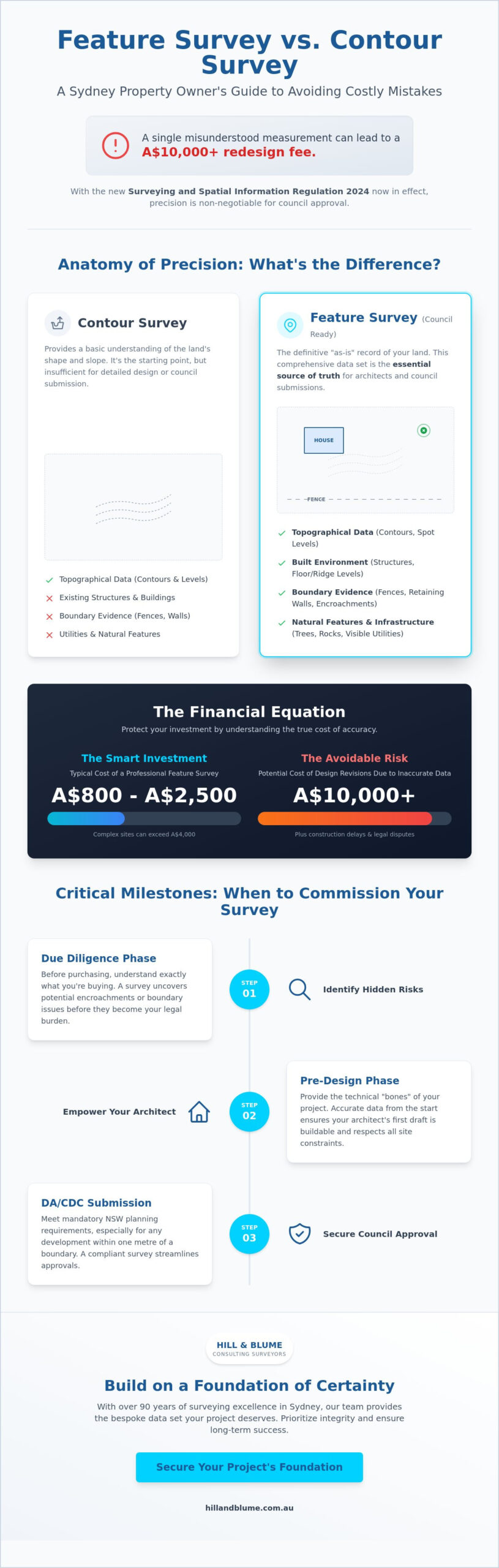
A single misunderstood measurement on your site plan can be the difference between a seamless council approval and a A$10,000 redesign fee. You likely already know that precision is the foundation of any successful build, yet the technical divide between a feature survey and a contour survey remains one of the most common hurdles for Sydney property owners. With the Surveying and Spatial Information Regulation 2024 now in full effect as of March 1, 2025, the stakes for accuracy and regulatory compliance have never been higher.
It’s natural to feel overwhelmed by the jargon. In Sydney, a standard residential survey typically costs between A$800 and A$2,500, but complex sites can quickly exceed A$4,000. We understand that you want to move forward with confidence, knowing your architect has the curated data they need to respect every boundary. In this guide, you’ll discover the critical distinctions between these survey types to ensure your project meets the City of Sydney’s stringent requirements. We’ll walk you through the current standards to help you avoid costly design errors and secure a stress-free path through the DA process.
Key Takeaways
- Distinguish between a standard contour study and a comprehensive feature survey to ensure every physical constraint is mapped before design begins.
- Learn why the City of Sydney requires specific detail and level data for any development within one metre of a property boundary.
- Understand how to navigate the NSW State Environmental Planning Policies (SEPP) to streamline your Complying Development Certificate (CDC) application.
- Protect your investment by identifying hidden site constraints and boundary encroachments early, preventing costly delays during the construction phase.
- Gain the confidence that your architectural vision is supported by a bespoke data set that prioritizes integrity and long-term project success.
The Essential Role of a Feature Survey in Sydney Property Development
Sydney’s property market demands more than just a cursory glance at a boundary line. A feature survey serves as the definitive “as-is” record of your land, capturing every nuance from the curve of a heritage sandstone retaining wall to the exact height of a neighbor’s roof ridge. While a basic land map might show a rough outline, it lacks the technical integrity required for modern architectural design. Understanding what is surveying is the first step in appreciating why these documents are the essential “source of truth” for your project. Without this precision, your architect is essentially drawing in the dark. Sydney isn’t flat. Our city is built on complex harbor slopes and sandstone ridges that require a bespoke approach to measurement.
Why Initial Site Data is Your Most Valuable Asset
Precision at the start of your journey eliminates the heartbreak of mid-construction surprises. Sydney’s unique topography makes professional measurement non-negotiable. If your site data is off by even a few centimeters, you risk expensive design revisions that can cost upwards of A$5,000 before a single brick is laid. A curated survey establishes a clear baseline for site levels, existing structures, and significant vegetation. This allows your team to navigate constraints with grace. It ensures your vision fits perfectly within the physical reality of the site. High-quality data reduces project risk by identifying underground services or structural encroachments long before the design phase concludes. It’s about protecting your investment from the ground up.
When Should You Commission a Feature Survey?
Timing is everything in property development. You should engage a registered surveyor during the pre-design stage to empower your architect with accurate data. This isn’t just about good design; it’s about legal compliance. Under the Surveying and Spatial Information Regulation 2024, which became active on March 1, 2025, surveys must meet rigorous new standards to be accepted by local councils. Any project not signed off before the January 1, 2026 transitional deadline must comply with these updated rules. You should commission a feature survey during these critical milestones:
- The Pre-Design Phase: Providing the technical “bones” of your project to ensure the first draft is buildable.
- DA/CDC Submission: Meeting mandatory NSW planning requirements for any development within one meter of a boundary.
- Due Diligence: Helping you understand exactly what you’re purchasing, uncovering potential encroachments before they become your legal burden.
By exploring our professional surveying services, you can ensure your Sydney development begins on a foundation of absolute certainty. We believe every property deserves a plan that reflects its true character and potential.
Anatomy of Precision: What a Comprehensive Feature Survey Captures
A comprehensive feature survey is essentially a high-definition portrait of your property. It doesn’t just show you where the land ends; it reveals the intricate layers of history and geography that define it. In a city as established as Sydney, this means documenting every sandstone outcrop and heritage-listed tree canopy with absolute integrity. According to the Institution of Surveyors NSW, the professional standards for these maps ensure that every measurement, from a subtle change in ground level to the exact position of a neighbor’s balcony, is recorded with surgical precision.
Your survey plan acts as a curated data set that includes:
- Topographical Data: Contours and spot levels across the entire site, providing a clear picture of the land’s natural flow.
- Built Environment: Exact footprints of existing structures, interior floor levels, and critical roof ridge heights.
- Boundary Evidence: The physical location of fences, retaining walls, and visible evidence of occupation.
- Natural Features: Trunk locations and canopy spreads of significant trees, alongside unique rock outcrops common in Sydney’s harbor suburbs.
- Infrastructure: Visible utility services, drainage pits, and connection points that dictate where you can safely build.
Capturing the Built and Natural Landscape
Mapping floor levels to the Australian Height Datum (AHD) is vital for determining height-of-building compliance. In many Sydney councils, exceeding a height limit by even 100mm can trigger a refusal or a costly redesign. We look beyond your own boundaries to document neighboring structures. This allows your architect to perform accurate privacy and overshadowing analysis, which is a common sticking point in modern development applications. Identifying significant vegetation early is equally critical. With Sydney’s strict tree preservation orders, knowing the exact location of a root zone can save you from a A$10,000 fine or a rejected plan.
The Technical Deliverables: From Field to CAD
The transition from the field to your architect’s desk must be seamless. We provide data in the industry-standard DWG format, which allows your design team to build their vision directly onto an accurate digital foundation. While 2D plans were once the norm, 3D data is becoming the standard for modern Sydney builds, especially on steeply sloping sites where vertical space is at a premium. This technical rigor ensures that your drainage and flood-risk assessments are based on the same AHD baseline used by local authorities. Once your design is finalised, partnering with a construction set out surveyor in Sydney ensures those precise measurements are translated accurately from plan to ground, preventing costly boundary disputes before a single footing is poured. If you’re ready to secure this level of detail for your site, feel free to discuss your project’s unique requirements with our team.
By investing in our curated surveying services, you ensure that every constraint is a known quantity. This clarity allows for a more creative and confident design process, anchored by the traditional integrity that Hill & Blume has provided for generations.
Feature Survey vs. Contour Survey: Navigating the Differences
While many people use the terms interchangeably, a distinct technical boundary exists between these two documents. A contour survey is essentially a vertical study of your land. It focuses on the rise and fall of the terrain, illustrating gradients and drainage patterns through topographical lines. In contrast, a feature survey provides a horizontal and vertical tapestry of the site. It captures the physical presence of every fence, tree, and utility pit. Choosing the wrong one can stall your project before it even begins. In the sophisticated world of Sydney property development, precision is not just a luxury; it’s a requirement for success.
Contour Surveys: Mapping the Land’s Shape
A contour survey is primarily concerned with the “lie of the land.” It uses lines to connect points of equal elevation, allowing an architect to understand the slope’s severity. This is often sufficient for large-scale rural fencing or basic landscaping projects where man-made constraints are minimal. However, in a dense urban environment like Sydney, ignoring the built landscape is a significant risk. A map that shows the slope but misses a neighbor’s overhanging eaves or a hidden stormwater pipe is incomplete. Reliance on elevation alone often leads to design conflicts that aren’t discovered until the construction phase, where changes can cost upwards of A$2,500 in emergency redesign fees.
The “Detail and Level” Hybrid: The Sydney Standard
In New South Wales, the industry has largely moved toward a combined standard known as a Detail and Level Survey. This is the preferred terminology for councils and planning authorities alike. At Hill & Blume, we recommend this holistic approach for all urban property projects. By merging the topographical data of a contour survey with the descriptive data of a feature survey, you create a seamless plan that satisfies the most demanding council requirements. It’s about providing a curated view of the site that leaves no room for ambiguity.
You can Explore our Detail and Level Survey services to see how we tailor these plans for Sydney’s unique harbor topography. This hybrid model ensures your design team works with a complete “source of truth.” Whether you’re navigating the Surveying and Spatial Information Regulation 2024 or seeking a Complying Development Certificate (CDC), having both elevation and feature data is essential. It’s the difference between a generic map and a bespoke risk-management tool that protects your vision and your investment.
Planning for Compliance: Why Local NSW Councils Require Detailed Site Data
Navigating the NSW State Environmental Planning Policies (SEPP) requires more than a simple sketch. Local councils like Woollahra, Waverley, or the Northern Beaches demand a level of precision that matches the prestige of their respective regions. If your proposed works are within one meter of a property boundary, the City of Sydney mandates a survey plan prepared by a registered surveyor. A feature survey provides the necessary data to calculate your Floor Space Ratio (FSR) and Landscaped Area with absolute integrity. These calculations aren’t just numbers; they determine the legal limits of your vision. In areas where every square meter of land is a premium asset, accurate data is the only way to avoid a protracted battle with planning authorities.
Local constraints often vary significantly between Sydney municipalities. While one council might focus heavily on the preservation of harbor views, another may prioritize the retention of deep soil zones for native vegetation. Your survey must reflect these nuances. It acts as the technical foundation for your “Statement of Environmental Effects,” proving that your project respects the local character and environmental standards of the community. Without this bespoke approach to site data, your application risks being returned for “further information,” adding weeks or months to your timeline. For a comprehensive overview of how professional measurement underpins every stage of the planning process, our essential guide to site surveys for Sydney property projects provides the detailed context you need before lodging any application.
DA vs. CDC: Choosing Your Planning Pathway
The choice between a full Development Application (DA) and a Complying Development Certificate (CDC) often hinges on the quality of your documentation. A CDC is designed to be a “fast-track” process, but it requires rigorous adherence to the SEPP. If your feature survey is missing a critical level or a neighboring structure’s height, your application will stall. For a full DA, councils require a comprehensive record of the existing site to assess privacy and overshadowing. This documentation acts as a bridge between your aspirations and the public interest. You can learn more about the role of a surveyor in Sydney to ensure you’re selecting the right expert for this high-stakes task.
Resolving Boundary Uncertainties Early
Many Sydney property owners fall into the trap of assuming their fence line is their legal boundary. In reality, fences are often misplaced by several centimeters, which can lead to costly encroachments during construction. A feature survey identifies these visible evidences of occupation and compares them against the legal title. This proactive approach prevents disputes with neighbors and ensures your project remains within legal limits. It’s about maintaining the integrity of the local fabric. For a deeper look at protecting your property’s perimeter, read our guide on the importance of boundary surveys in Sydney. When construction begins, engaging a dedicated construction set out surveyor in Sydney ensures those resolved boundaries are precisely marked on the ground, keeping your build compliant from the first peg to the final inspection.
Ready to secure your project’s compliance? Contact our team today to discuss how a bespoke survey plan can streamline your path to approval.
The Hill & Blume Advantage: 90 Years of Surveying Excellence in Sydney
Since 1932, Hill & Blume has been a defining presence in the Australian surveying landscape. We’ve witnessed the evolution of the Sydney basin from its traditional roots to the sophisticated metropolis it is today. When you commission a feature survey from our team, you aren’t just receiving a technical document. You’re engaging with a legacy of precision that spans nearly a century. Our work bridges the gap between historical land titles and the rigorous demands of the Surveying and Spatial Information Regulation 2024. This depth of knowledge ensures your project is anchored in truth, whether you’re developing a heritage terrace in Paddington or a modern masterpiece on the Central Coast.
Our reach extends across Sydney, Newcastle, and the Central Coast, bringing a bespoke approach to every site we touch. We believe that every property deserves a curated survey plan that reflects its unique character. By blending traditional integrity with modern laser-scanning technology, we provide a seamless data set that satisfies both your creative vision and council’s strict requirements. It is about more than just points on a map; it’s about the partnership we build with you to ensure your project’s longevity.
Why Experience Matters in the Sydney Market
Sydney’s property records are a complex tapestry of historical cadastral data and aging land titles. Navigating these requires a boutique touch and a deep understanding of local history that only comes with decades of immersion. We prioritize a partnership-oriented narrative, working closely with your architect and builder to ensure every measurement supports the structural integrity of your design. We choose quality over high-volume turnover. This means your plan is handled with the care it deserves, reflecting the same commitment to excellence that defines our presence in the Southern Highlands. We treat every site as a unique canvas, ensuring that your architectural vision is never compromised by inadequate data.
Secure the Foundation of Your Project
A successful development starts with a single, accurate point of data. When you work with a Hill & Blume registered surveyor, you can expect a polished and professional experience from the initial site visit to the final delivery of your digital files. We provide a tailored approach to every quote, ensuring the scope of your feature survey aligns perfectly with your specific planning pathway. We’re here to provide the calm confidence you need to navigate the complexities of modern construction. It’s time to build your vision on a foundation of absolute certainty.
Contact the Hill & Blume team today to discuss your project and discover the difference that 90 years of surveying integrity can make for your Sydney property.
Build Your Sydney Vision with Absolute Certainty
Your property project deserves a foundation built on integrity and technical excellence. We’ve explored how a comprehensive feature survey acts as the definitive source of truth, bridging the gap between your architectural aspirations and Sydney’s rigorous planning realities. By identifying physical constraints and legal boundaries early, you protect your investment from the friction of council delays or the heartbreak of mid-construction redesigns. It’s about more than just data; it’s about the peace of mind that comes from professional precision.
With a legacy of expertise serving the Sydney region since 1932, Hill & Blume provides the calm confidence you need to navigate complex planning laws across Sydney, Newcastle, and the Central Coast. Our registered surveyors ensure your documentation meets every legal standard, allowing you to focus on the artistry of your build. We invite you to secure your project’s precision by contacting Hill & Blume for a bespoke survey quote. Your vision is a significant undertaking. Let’s ensure it begins with the clarity and craftsmanship it deserves.
Frequently Asked Questions
Is a feature survey the same as a boundary survey?
No, these documents serve different technical and legal purposes. A feature survey maps the physical characteristics of the land, such as existing buildings, trees, and ground levels. A boundary survey is a legal determination of your property’s title limits. For most Sydney developments, we combine these into a single, seamless plan to satisfy both your architect’s design needs and the council’s legal requirements.
How much does a feature survey cost in NSW in 2026?
As of early 2026, a standard residential feature survey in Sydney typically costs between A$800 and A$2,500. If your property features steep harbor slopes, heavy vegetation, or difficult access, costs often range from A$2,500 to over A$4,000. These values reflect the increased technical rigor required to comply with the Surveying and Spatial Information Regulation 2024.
How long does it take to complete a feature and level survey in Sydney?
Most standard residential projects require approximately five to ten business days from the initial site visit to the final delivery of your digital CAD files. This timeframe allows our team to conduct meticulous fieldwork followed by a curated drafting process. Complex heritage sites or larger land parcels may require additional time to ensure every detail is captured with absolute integrity.
Can I use an old survey from the previous owner for my DA?
Relying on an outdated survey is a significant risk that frequently leads to DA rejection. Under the Surveying and Spatial Information Regulation 2024, any plan not signed before January 1, 2026, must comply with the new, stricter standards. Site conditions change as fences are moved or trees grow, and using old data can lead to boundary encroachments that cost thousands to rectify during construction.
Do I need a feature survey for a simple home extension or granny flat?
Yes, you almost certainly need a professional site survey for these projects. Any development within one meter of a property boundary requires a registered survey plan to secure council approval. This data ensures your extension respects height limits and Floor Space Ratio (FSR) requirements. It’s the most reliable way to move through the Complying Development Certificate (CDC) process without unexpected delays.
What is the difference between AHD and assumed levels?
Australian Height Datum (AHD) is the official national vertical datum based on mean sea level. Assumed levels are relative only to a specific point on your site and lack broader geographic context. Sydney councils mandate the use of AHD for flood-risk assessment and height-of-building compliance, ensuring your project integrates seamlessly with the surrounding urban infrastructure.
Does a feature survey include underground utility locations?
A standard survey captures visible infrastructure such as drainage pits, water meters, and sewer manholes. While it provides a clear picture of surface evidence, it doesn’t typically include the precise path of underground pipes. If your project involves deep excavation, we recommend engaging a specialized utility locating service to complement your site data and ensure a safe construction process.
Why do I need a registered surveyor for a feature survey?
Only a registered surveyor has the legal authority to sign off on plans submitted to NSW councils and government authorities. Their credentials provide a seal of quality and ensure your project complies with the Surveying and Spatial Information Act 2002. This professional oversight protects your property rights and gives your design team the confidence of working with verified, high-integrity data.
Disclaimer
The information provided in articles published on this website is for general informational purposes only. While we make every effort to ensure the accuracy, completeness, and timeliness of the content, the material is based on our understanding of the industry at the time of writing and may not reflect the most current developments, regulations, or standards. All opinions expressed in our articles are those of the respective authors and do not necessarily represent the official position of the website or its affiliates. The content should not be considered professional, legal or technical advice, and should not be relied upon as a substitute for consultation with qualified professionals