
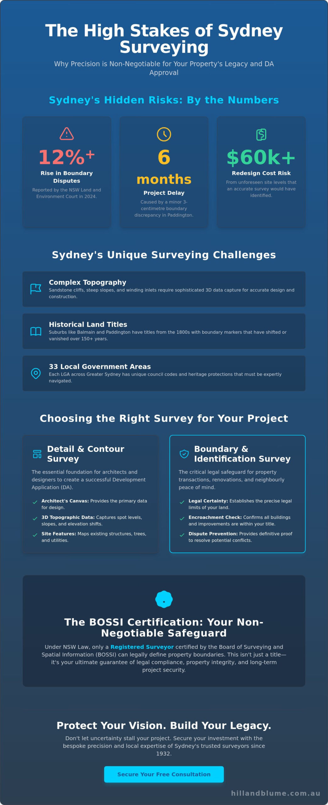
Last October, a homeowner in Paddington discovered that a minor three-centimetre discrepancy in their boundary line resulted in a six-month delay for their terrace restoration. In 2024, the NSW Land and Environment Court reported a 12% rise in residential boundary disputes, a statistic that highlights the fragile nature of property lines in our densifying city. You shouldn’t have to carry the anxiety of potential litigation or the frustration of a stalled DA approval. We understand that your home is more than just an address; it’s a legacy that requires a bespoke approach to protect its integrity.
Finding a sydney surveyor who values precision as much as you value your time is the first step toward a seamless project. You deserve a partnership grounded in trust and local expertise, ensuring every detail aligns with current NSW planning regulations. This guide provides the clarity you need to distinguish between complex survey types and secure legal certainty for your boundaries. We’ll walk you through the essential steps to achieve a swift CDC or DA approval while safeguarding the long-term value of your investment through a curated, professional experience.
Key Takeaways
- Understand why navigating Sydney’s unique topography and historical layouts requires a specialized sydney surveyor to ensure your property’s vision is built on a foundation of absolute precision.
- Learn to identify the specific NSW survey requirements for your project, from boundary definitions to essential DA approvals, ensuring a seamless path through local regulations.
- Discover the critical legal distinction of a Registered Surveyor and why BOSSI certification is your ultimate safeguard for property integrity and long-term compliance.
- Master your project timeline by identifying the exact moments to engage expert surveying services, avoiding costly bottlenecks from the initial design phase to the final Occupational Certificate.
- Explore how a bespoke, legacy-driven approach to surveying can transform a standard development into a curated property investment defined by quality and craftsmanship.
The Essential Role of a Sydney Surveyor in Modern Property Development
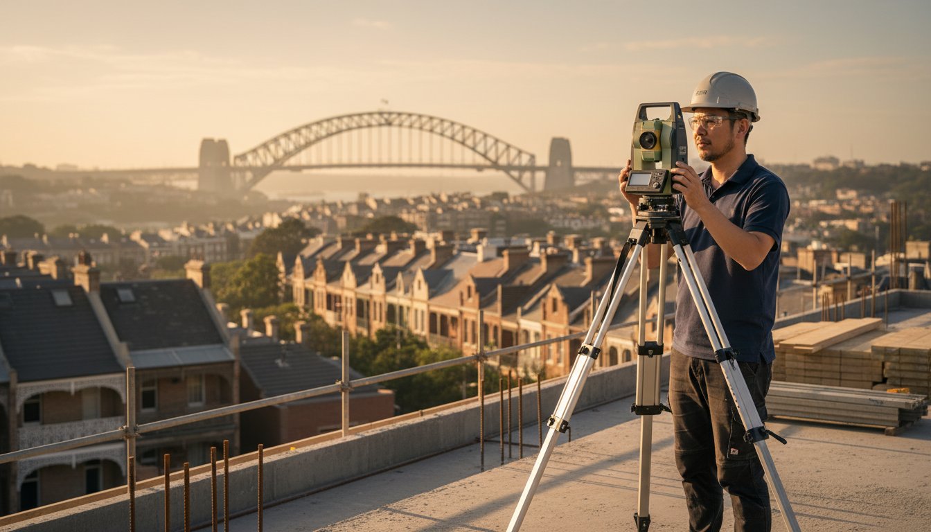
In the high-stakes environment of Sydney real estate, your vision deserves more than just a rough estimate. A professional sydney surveyor does more than measure soil; they translate the complex physical reality of our harbour city into the precise language of NSW property law. This process forms the bedrock of every successful development. It ensures your investment remains secure from the initial site visit to the final settlement. Professional Surveying acts as a vital bridge between the abstract lines on a title deed and the tangible boundaries of your land.
Sydney’s landscape is a beautiful, rugged tapestry of sandstone cliffs, winding inlets, and elevation shifts that challenge even the most experienced developers. Navigating this terrain requires a deep understanding of the intersection between physical measurement and the legal frameworks established by the NSW Land Registry Services. Think of this expertise as a bespoke form of insurance. It protects you against the devastating costs of boundary disputes or structural encroachments that can stall a project for years. By identifying potential issues before the first brick is laid, you’re not just buying data; you’re investing in peace of mind.
Why Local Sydney Knowledge is Non-Negotiable
In historic suburbs like Paddington or Balmain, where terrace houses often share centuries-old party walls, the margin for error is non-existent. These areas rely on historical land titles dating back to the mid-1800s. In many cases, original boundary markers have shifted or disappeared entirely over the last 150 years. A seasoned sydney surveyor understands how to interpret these legacy documents alongside modern satellite data. We navigate the specific requirements of the 33 Local Government Areas (LGAs) across Greater Sydney, ensuring your project aligns with unique council codes and heritage protections from day one.
Surveying Beyond the Boundary: The Broader Impact
Our work extends far beyond defining simple fence lines. We provide the vital data that fuels Sydney’s urban planning and high-end infrastructure. When an architect receives a precise digital terrain model, they can design with total confidence. This accuracy eliminates the risk of a A$60,000 redesign mid-construction due to unforeseen site levels. At Hill & Blume, we call this “precision with purpose.” It’s a curated approach that prioritizes your project’s integrity, ensuring every measurement contributes to a seamless, sophisticated build. We don’t just mark points on a map; we help you build a legacy in the city we call home.
Navigating Sydney’s Surveying Requirements: From Boundaries to DA Approvals
Understanding the regulatory landscape in New South Wales is the first step toward realizing your architectural vision. Whether you’re planning a bespoke renovation in Paddington or a sophisticated new build overlooking the harbor, your journey begins with precision. Every project has unique demands, and identifying the correct survey type early saves you from the frustration of administrative delays.
Detail and Contour Surveys: The Architect’s Blueprint
Architects rely on the Detail and Level Survey as their primary canvas. For a successful Sydney Development Application (DA), this survey must capture far more than just the perimeter of your lot. It requires a sophisticated collection of 3D data, including spot levels, existing structures, and significant vegetation. Sydney’s iconic sloping terrain makes this data vital; without accurate topographic information, your design risks costly revisions or Council rejection. You can explore Hill & Blume’s Detail and Level Surveys to see how we provide this essential foundation for your design team.
Boundary and Identification Surveys: Legal Peace of Mind
Legal clarity is non-negotiable during property transactions. A simple fenceline check isn’t enough to protect your investment or your peace of mind. A formal Boundary Survey establishes the precise legal limits of your land, while an Identification Report confirms that the dwelling and all improvements reside within those boundaries. This document is a curated record of the property’s physical relationship to its legal title.
Sydney banks and financial institutions frequently require these reports before approving mortgages on high-value estates. This rigorous standard is upheld by the state, as seen in the official NSW surveyor application process, which ensures only qualified professionals handle these sensitive legal documents. Engaging a qualified sydney surveyor ensures that every measurement is backed by professional indemnity and deep local expertise.
Disputes over a few centimeters can halt a project or sour a neighborly relationship. Our role as your sydney surveyor is to provide an objective, professional analysis that resolves encroachment issues before they escalate. It’s about bringing integrity to every measurement and ensuring your property rights are respected. We look for hidden easements or structural overlaps that might not be visible to the untrained eye.
If you’re unsure which report your specific project requires, a brief conversation with our team can provide the bespoke guidance you need to move forward with confidence and clarity.
Why Being a “Registered Surveyor” Matters Under NSW Law
Choosing a professional for your property isn’t just about technical skill; it’s about legal authority. In New South Wales, the Surveying and Spatial Information Act 2002 is explicit. Only a Registered Surveyor can legally define land boundaries. If you hire an unlicensed person for boundary work, the result holds no weight in a court of law or with government bodies. This distinction protects your property rights and ensures the integrity of the state’s land title system. It’s a safeguard that prevents costly disputes between neighbors and ensures the public can trust the markers placed in the ground.
The Board of Surveying and Spatial Information (BOSSI) serves as the regulatory gatekeeper in NSW. They oversee the registration process, ensuring every sydney surveyor who carries the title has passed rigorous examinations and maintains ongoing professional development. This oversight is why Hill & Blume prioritizes registration as a core pillar of our service. It’s a seal of quality that guarantees your project adheres to the highest ethical and technical benchmarks. We’ve seen how unlicensed work can lead to property disputes that last for years, costing owners thousands in legal fees. You can avoid these pitfalls by verifying credentials from the start, and our 2026 professional selection guide for registered land surveyors in Sydney provides a definitive framework to help you make the right choice.
The Legal Weight of a Registered Signature
A survey is more than a drawing. It’s a legal document that speaks to the NSW Land Registry Services (LRS). When you’re managing a subdivision or a complex strata plan, the LRS requires a registered signature to update land titles. Without it, your project stalls. The consequences of using an unregistered individual are often hidden until a sale or development application fails, leading to significant delays and unbudgeted costs. “In NSW, a survey is only as legally binding as the registration of the person who signed it.” This signature also brings the protection of professional indemnity insurance, ensuring your investment is shielded from technical errors. It’s the difference between a seamless approval and a bureaucratic nightmare.
BOSSI Standards and Professional Integrity
Achieving registration in NSW is a marathon, not a sprint. It requires years of university study followed by a period of supervised practical experience and grueling professional assessments. Hill & Blume carries this legacy of excellence into every Sydney project we undertake. We don’t just follow the rules; we embrace a bespoke approach that treats your land with the respect it deserves. This dedication provides our clients with a sense of calm confidence. You’ll know that your boundaries are defined by an expert who values precision and long-term partnership over quick turnovers. Our commitment to BOSSI standards means your property vision is supported by a foundation of absolute integrity and a 90 year history of local expertise.
Integrating Surveying into Your Sydney Project Timeline
A successful build isn’t just about the architecture; it’s about the precision of the foundation. Engaging a sydney surveyor early ensures your vision aligns with the physical reality of the land. We view the surveying process as a chronological partnership that safeguards your investment from the first site visit to the final handover. By integrating professional expertise into your project timeline, you avoid the bottlenecks that often derail complex urban developments.
Phase 1: Pre-Design and DA/CDC Preparation
A bespoke project begins with clarity. You should engage a surveyor before an architect draws a single line. A Detail and Level Survey serves as the “source of truth” for your site, mapping every contour and existing structure. For those embarking on multi-dwelling developments, considering Strata and Community Title Plans at this stage is vital for defining future ownership boundaries.
Early surveying identifies critical constraints like easements that could restrict your building envelope. Finding a 1.5-meter drainage easement or a protected Sydney Water asset during the initial design phase prevents the need for a total redesign. In the Sydney market, a late discovery of these restrictions can delay a Development Application (DA) or Complying Development Certificate (CDC) by 3 to 6 months. Starting with an accurate site plan ensures your design is both ambitious and achievable.
Phase 2: Construction and Compliance Monitoring
Once your plans are approved, the focus shifts to the “Construction Set-out.” This must be completed before the first slab is poured. During the “Peg-out” process, we mark the exact position of your footings on the ground, ensuring your builder stays within legal setbacks and property lines. Our team provides the following essential checks during the build:
- Slab Checks: Verifying the formwork is correctly positioned before concrete is poured.
- Height Certifications: Confirming the building height remains within the limits set by your DA or CDC.
- Identification Survey: A final report needed for the final sign-off, showing the location of the finished building in relation to the boundaries.
The concluding phase involves “Work-as-Executed” (WAE) surveys. Sydney Water and local councils, such as the City of Sydney or Inner West Council, require these plans to confirm that infrastructure like stormwater systems was built according to the original design. This WAE plan is a non-negotiable requirement for obtaining your Occupational Certificate (OC). It’s the seal of quality that proves your project was executed with integrity and precision.
Hill & Blume: A Legacy of Precision and Bespoke Solutions Since 1932
Since opening our doors in 1932, Hill & Blume has witnessed the transformation of the Sydney skyline firsthand. Over nine decades, we’ve evolved from a small local practice into a premier sydney surveyor known for balancing traditional integrity with modern innovation. We don’t view your project as just another file in a high-volume queue. Instead, we treat every boundary, contour, and detail as a unique puzzle that requires a bespoke approach. This commitment to craftsmanship has allowed us to remain a cornerstone of the industry for over 92 years, providing a level of care that clinical, corporate firms often overlook.
The Boutique Experience: Why Depth of Relationship Matters
We prioritize the depth of our relationships over the breadth of our turnover. This philosophy ensures that when you partner with us, you’re gaining a trusted local expert who understands the specific nuances of Sydney’s terrain. From complex residential surveys in Crows Nest to sprawling commercial developments across the broader metropolitan area, our team delivers data that feels hand-crafted and precise.
Our process focuses on the seamless integration of technical data with your creative vision. We ensure our digital outputs are compatible with modern architectural software, including BIM and CAD platforms, which reduces friction during the design phase. Our deep roots in the local community mean we aren’t just measuring land; we’re helping build the future of the city we call home. We take the time to understand your goals, offering a partnership-oriented narrative that prioritizes quality over quantity.
Securing Your Property’s Future
Choosing the right sydney surveyor is about more than just obtaining a certificate. It’s about the peace of mind that comes from a “seal of quality” recognized by local councils and developers alike. Our 92-year history serves as a guarantee that your property’s documentation is handled with the highest level of professional rigor.
We invite you to move beyond the transactional and enter into a considered conversation about your project. Whether you’re navigating a sophisticated subdivision or a simple boundary realignment, our expertise ensures your investment is protected by nearly a century of proven precision. Every project is an opportunity to continue our legacy of excellence, and we look forward to bringing that same dedication to your site.
Crafting Your Sydney Legacy with Unwavering Precision
Navigating the complexities of property development in 2026 requires more than just technical skill; it demands a partnership built on trust and a deep understanding of NSW property law. You’ve seen how essential it’s to engage a professional who understands that every boundary line and DA approval represents a critical step in protecting your investment. Precision isn’t just a checkbox, it’s the very foundation of your project’s success.
Since 1932, Hill & Blume has provided this foundation for the city’s most discerning property owners. With over 90 years of excellence, we bring a curated, bespoke approach to every site, ensuring your development timeline remains seamless and stress-free. Our Registered Surveyors are the trusted choice for Sydney’s leading architects and developers because we prioritize depth of relationship over high-volume turnover. When you partner with a sydney surveyor from our team, you’re engaging with a legacy of integrity and craftsmanship. Let’s transform your vision into a precisely mapped reality.
Request a bespoke survey proposal for your Sydney property
Frequently Asked Questions
What is the difference between a land surveyor and a registered surveyor in NSW?
A registered surveyor in NSW holds a formal qualification and is legally licensed by the Board of Surveying and Spatial Information (BOSSI) to determine land boundaries. While a land surveyor might assist with various spatial tasks; only a registered professional can sign off on legal documents. This distinction ensures your property rights remain protected under the Surveying and Spatial Information Act 2002. It is a hallmark of the integrity we bring to every project.
How much does a boundary survey cost in Sydney in 2026?
Boundary survey costs in Sydney for 2026 typically reflect the complexity of the site and the availability of historical survey marks. Most standard residential lots require a bespoke quote, but industry data from the Association of Consulting Surveyors NSW indicates that professional fees often start from A$1,500 for basic boundary marking. Your final investment depends on whether your land is a simple rectangular lot or a complex site with steep terrain. For a comprehensive breakdown of what influences pricing across different survey types, our guide to understanding land survey cost in Sydney offers transparent, detailed insight for homeowners planning their 2026 projects.
Do I need a survey for a new fence or retaining wall in Sydney?
You definitely need a survey before installing a new fence or retaining wall to avoid costly legal disputes with neighbors. Relying on old fence lines is risky because 15% of suburban fences are estimated to be off-line by at least 100mm. A precise boundary marking ensures your new structure is positioned with absolute certainty. This proactive approach protects your investment and maintains the harmony of your local community.
How long does a typical detail and level survey take to complete?
A typical detail and level survey generally takes between 5 and 10 business days to move from the initial site visit to the final digital delivery. Our team spends approximately 4 to 6 hours on-site capturing thousands of data points with high-precision equipment. Back in the office, we spend another 8 to 12 hours drafting your bespoke plan. This timeline ensures every contour and existing feature is mapped with the accuracy your architect requires.
What is an encroachment, and how can a Sydney surveyor help resolve it?
An encroachment happens when a building, gutter, or wall built on one property extends onto another person’s land. As your sydney surveyor, we identify these overlaps by comparing physical structures against the legal title boundaries. We provide an Identification Survey report that documents the exact extent of the intrusion in millimeters. This clear, professional evidence is essential for resolving disputes or negotiating easements with your neighbors.
Can a surveyor help with a Strata Plan for a dual occupancy in Sydney?
A surveyor is essential for creating a Strata Plan for your dual occupancy to legally separate the two dwellings into individual titles. This process involves measuring the internal and external dimensions of the buildings to define the lots and common property. We then lodge these plans with NSW Land Registry Services. It is a sophisticated process that adds significant value to your property by allowing for independent sales or refinances.
Why does my Sydney council require a Work-as-Executed (WAE) survey?
Your Sydney council requires a Work-as-Executed (WAE) survey to confirm that your completed drainage or civil works align with the approved development plans. This is a mandatory step for obtaining an Occupation Certificate for 95% of modern developments. The WAE survey provides a permanent record of underground services and floor levels. It gives the council and future owners confidence that the infrastructure was built to the exact engineering specifications.
What information is included in an Identification Survey report?
An Identification Survey report includes a detailed sketch showing the land’s boundaries and the position of all structures relative to those lines. It highlights any encroachments by or upon the land and lists any registered easements or covenants. This document is a vital piece of the due diligence puzzle when you’re purchasing a home. It offers a curated view of your potential investment, ensuring there are no hidden legal surprises waiting for you.
Disclaimer
The information provided in articles published on this website is for general informational purposes only. While we make every effort to ensure the accuracy, completeness, and timeliness of the content, the material is based on our understanding of the industry at the time of writing and may not reflect the most current developments, regulations, or standards. All opinions expressed in our articles are those of the respective authors and do not necessarily represent the official position of the website or its affiliates. The content should not be considered professional, legal or technical advice, and should not be relied upon as a substitute for consultation with qualified professionals