

What if the most significant investment in your property isn’t the architecture you admire, but a silent legal boundary you cannot even see? When you’re planning a dream build or resolving a neighborly dispute, the initial survey cost can feel like an unexpected hurdle, especially when quotes vary so widely across Sydney’s harborside and suburban landscapes. You likely feel a sense of hesitation when faced with technical jargon, or perhaps you worry that you’re overpaying for what looks like a simple map. We understand that your home is your most valuable asset, and every detail of its footprint deserves the highest level of care and precision.
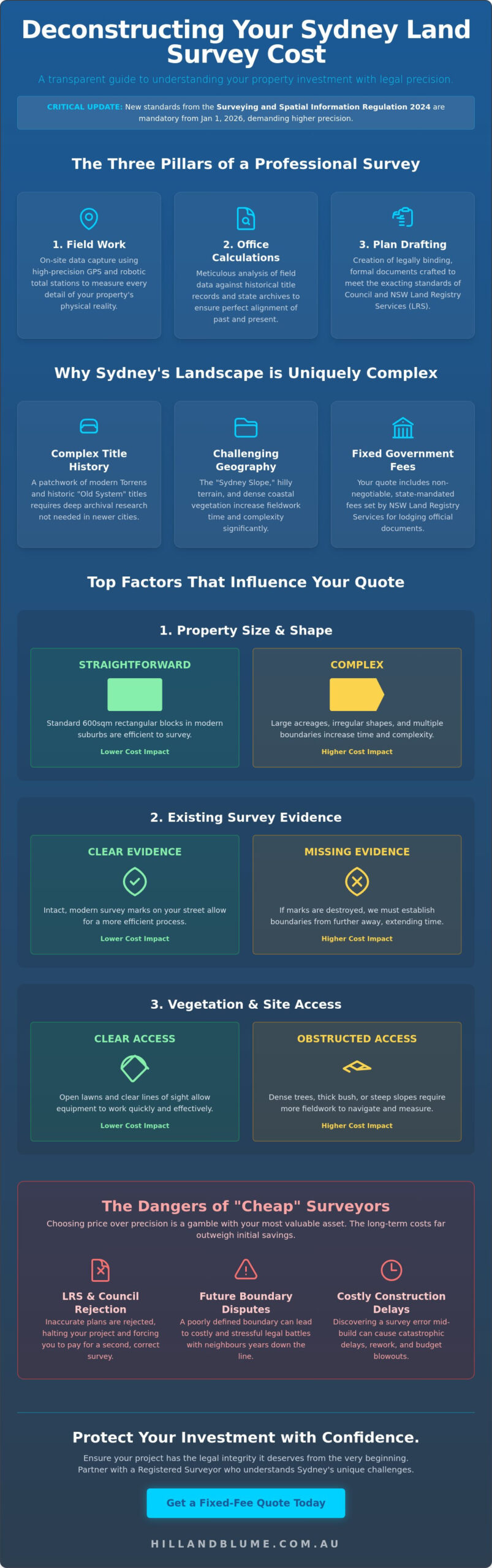
This guide offers you a transparent look at the craftsmanship behind professional surveying in 2026. Since the transition period for the Surveying and Spatial Information Regulation 2024 ends on January 1, 2026, the standards for legal precision have never been more rigorous. We’ll explore how Sydney’s complex title history and rugged terrain influence your investment; providing you with a clear framework to evaluate quotes with confidence. You’ll gain the certainty that your survey will be accepted by the Land Registry Services, ensuring your project moves forward with grace and total legal integrity.
Key Takeaways
- Learn how a fixed-fee approach provides you with financial clarity by balancing intricate fieldwork with the rigorous legal requirements of the 2024 regulations.
- Understand how the unique character of your Sydney land, including its terrain and title history, defines the final survey cost of your project.
- Identify the specific survey type required for your development to ensure every plan is accepted by Council and the Land Registry Services without delay.
- Discover the long-term value of choosing precision over price to protect your property from future boundary disputes and administrative rejections.
- Gain a clear framework for requesting quotes that leverage local knowledge, ensuring your surveyor acts as a true partner in your property journey.
What Determines Land Survey Cost in Sydney?
When you receive a quote for your property, you’re looking at more than a simple set of numbers; you’re viewing a carefully calculated investment in the legal certainty of your home. Your total survey cost is an amalgam of three distinct phases: rigorous field measurements, deep historical research, and the formal drafting of plans that meet the exacting standards of the New South Wales government. While some online platforms might suggest that surveyors work on a simple hourly rate, most established Sydney firms provide a fixed-fee quote. This approach offers you financial peace of mind, as it’s based on a clearly defined scope of work tailored to your specific land and project goals.
It’s vital to understand that a Registered Surveyor in NSW is more than a technician. They are legal officers with a professional responsibility to the crown and the community. When they define a boundary, they aren’t just giving you a “quick check” of where a fence might sit. They’re providing a legally binding definition that can stand up in a court of law. To truly grasp the complexity of this profession, one might ask, What is land surveying? It’s the sophisticated science of determining three-dimensional positions, a discipline where even a few millimeters of error can lead to costly construction delays or neighborly disputes.
The Three Pillars of a Survey Quote
- Field Work: This involves our experts physically visiting your site to capture data using high-precision GPS and robotic total stations. It’s the foundation of every plan we create.
- Office Calculations: Once we return from the field, we analyze the raw data against historical title records and previous surveys stored in the state archives. This ensures your property’s history is perfectly aligned with its current state.
- Plan Drafting: The final stage is the creation of formal documentation. Whether it’s for a Council Development Application or an LRS lodgement, these plans are crafted with meticulous detail to ensure seamless approval.
Why Sydney Prices Differ from National Averages
Sydney’s property landscape is uniquely complex. Our city is built upon a patchwork of Torrens Title and ancient “Old System” titles, some of which date back to the early days of the colony. Resolving these historical discrepancies requires a level of expertise and research time that isn’t typically necessary in newer, more uniform developments across Australia. This historical depth is a primary factor in the final survey cost for local homeowners.
Geography also plays a significant role. The “Sydney Slope” is a reality for many residents in the Northern Beaches or the Eastern Suburbs. Hilly terrain and dense coastal vegetation increase the time required for field crews to establish a clear line of sight for their equipment. Finally, your quote includes fixed fees set by the NSW Land Registry Services (LRS). These state-mandated charges for lodging documents are consistent across the board, ensuring that the administrative portion of your survey remains transparent and official.
Top Factors That Influence Your Survey Quote
Your property is unique, and the path to defining its boundaries is rarely a straight line. While it’s tempting to view surveying as a standard service, your survey cost is dictated by the specific physical and legal realities of your land. A significant portion of the work happens before a surveyor even sets foot on your grass. This “search vs. field” split is a detail often overlooked in generic quotes. We balance hours of meticulous archival research with precise on-site data collection to ensure your investment is protected. If you’re curious about how these factors apply to your specific project, you can reach out for a personal consultation to discuss your site’s requirements.
Property size and shape are the most visible influences on your quote. A standard 600sqm rectangular block in a modern suburb is relatively straightforward to define. However, irregular boundaries or large acreages require more time to traverse and measure. Beyond size, we look for existing survey evidence. If your street has intact, modern survey marks, the process is efficient. If those marks have been destroyed by decades of roadwork or landscaping, we must “bring in” levels and boundaries from further away, which naturally extends the time required for a high-quality result.
Vegetation and Site Access
If your home sits within the leafy corridors of the North Shore or the rugged, coastal terrain of the Northern Beaches, vegetation becomes a primary factor in your survey cost. Traditional surveying equipment requires a clear “line of sight” to take accurate measurements. Thick lantana, heavy scrub, or even well-established ornamental gardens can block these paths. In these instances, our team must spend additional time establishing “clearing lines” to ensure every measurement is mathematically perfect. A site that is clear and easily accessible will always receive a more competitive quote than one requiring significant physical navigation through dense greenery.
The Complexity of the Land Title
The legal history of your land is just as important as its physical shape. Most modern Sydney properties are under Torrens Title, which is generally efficient to process. However, if your property is part of a complex Strata or Community Title, the layers of shared boundaries and common property add significant depth to the drafting process. The most complex cases involve “Old System” land, which is still found in inner-city pockets. These titles require our experts to trace a chain of ownership and boundary definitions through the NSW Land Registry Services archives. Re-establishing a boundary that hasn’t been formally surveyed in over 50 years is a delicate task that demands the highest level of craftsmanship and care. Hidden encumbrances such as utility corridors and rights of way can further complicate this process, which is why understanding the full scope of an easement survey NSW is an essential part of any thorough title investigation.
Comparing Survey Types: Which One Do You Need?
Selecting the correct survey type is an essential step in protecting your property’s future. While it’s tempting to search for the lowest initial quote, the cheapest option often lacks the specific data your architect or the local council requires. This mismatch can lead to expensive revisions later in the project. By understanding the distinct professional surveying services available, you can ensure your investment provides the exact legal and physical clarity needed for your specific goals. Often, the most sophisticated approach is to combine requirements, such as a Detail and Boundary survey, into a single site visit. This coordination reduces your overall survey cost while providing a comprehensive dataset for your entire project team.
Professional standards in our industry are maintained by organizations like The Association of Public Authority Surveyors, ensuring that the data we provide is both accurate and legally robust. When you engage a specialist, you aren’t just buying a map; you’re securing a guarantee that your project rests on a foundation of verified truth. This is particularly vital in Sydney, where historical boundary complexities require a discerning eye and a deep understanding of local land law.
Boundary vs. Identification Surveys
It’s easy to confuse these two services, yet they serve very different purposes. A Boundary Survey is a physical act of marking your land. We place pegs or marks at the corners of your property, which is essential if you’re planning new fencing or building right to the edge of your lot. Because this often requires a plan to be lodged with the Land Registry Services to update the public record, it carries a different administrative weight. For a detailed breakdown of what professional pricing looks like for this specific service in 2026, our guide to boundary survey cost NSW walks you through every factor that shapes your investment.
An Identification Survey, by contrast, is a signed professional report usually requested during a property sale or by a financial institution. It identifies the levels of the land and the position of any structures, checking for encroachments by or upon the property. While it provides peace of mind during a transaction, it doesn’t always involve the physical pegging of corners that a construction project demands. Understanding this distinction helps you avoid paying for a report when you actually need physical markers on the ground.
Detail and Contour Surveys for DA
If you’re embarking on a renovation or a new build, a contour and detail survey is your gold standard. This survey captures the “living” elements of your site, including ground levels, significant trees, neighboring structures, and visible utility services. It’s the essential canvas your architect needs to design a home that harmonizes with the land. A common pitfall for homeowners is assuming a standard detail survey automatically defines legal boundaries. In many cases, it doesn’t. Explicitly requesting a combined Detail and Boundary survey is the most cost-effective way to ensure your survey cost covers both the creative needs of your designer and the legal requirements of the Council.
The Hidden Costs of Hiring “Cheap” Surveyors
You’ve likely seen the variation in quotes. Someone online offers a rate that seems too good to pass up, perhaps promising a quick turnaround for a fraction of the price. But in the world of professional surveying, a lower price often signals a reduction in the depth of research or the level of insurance protection. When you prioritize a minor saving on your initial survey cost, you might inadvertently inherit a legacy of legal and administrative complications that far outweigh the initial discount. Precision is not a commodity; it’s a promise of security for your most valuable asset.
Choosing a surveyor based solely on a price point ignores the professional liability they carry. Reputable Sydney firms maintain significant Professional Indemnity insurance, which acts as a safeguard for your property investment. This insurance isn’t just a business expense; it’s a reflection of the surveyor’s commitment to standing behind their work. Without this, you’re left vulnerable to errors that may not surface until your construction is well underway, at which point the “savings” you found online will seem insignificant compared to the cost of remediation.
Council Rejections and DA Delays
Sydney councils, particularly in heritage-rich areas like Woollahra or the bushfire-prone Northern Beaches, operate with a refined eye for detail. They don’t just look for a map; they require a document that adheres strictly to the Surveying and Spatial Information Regulation 2024. Since the transition period for these regulations ended on January 1, 2026, any plan that fails to meet these rigorous standards is swiftly rejected. The cost of “doing it twice” is more than just financial. It represents the loss of months in your construction timeline and the potential for increased holding costs on your property. Professional firms ensure first-time acceptance because they treat every project as a unique partnership, rather than a high-volume transaction.
In a similar vein, maintaining your own health and physical alignment is essential when navigating the complexities of a property development. For residents in the Woollahra area, the gentle and transformative care provided by livelovelifechiropractic.com.au offers a way to manage the stresses of construction and ensure you are operating at your best.
Boundary Disputes and Legal Liability
The nightmare scenario isn’t a rejected plan; it’s a boundary dispute discovered years after the build is complete. Constructing a retaining wall, a garage, or even a simple fence just 10cm over the legal line can lead to legal fees and remediation costs exceeding $50,000. Your only robust legal protection in a NSW court is the signature and seal of a Registered Surveyor. This mark of quality confirms that the work is backed by exhaustive historical research and significant Professional Indemnity insurance. It’s the difference between a simple drawing and a legally binding document. Undisclosed easements and rights of way are among the most common triggers for such disputes, making a thorough easement survey NSW an indispensable safeguard before any construction begins. To understand how to vet your partners and ensure they have the necessary credentials, consult The Definitive Guide to Hiring a Sydney Surveyor for essential selection criteria.
If you value precision and want to ensure your property’s future remains secure, contact our team today for a considered, professional quote that reflects the true value of your land.
How to Get an Accurate Survey Quote for Your Project
Securing a precise, fixed-fee quote for your property is the first step toward a seamless development journey. It transforms the survey cost from an uncertain variable into a defined investment in your home’s future. When you provide comprehensive details at the outset, you allow us to tailor our approach to the unique rhythm of your land and the specific requirements of your local council. This clarity ensures that the quote you receive is not just a number, but a commitment to the legal and physical integrity of your project. We view this process as the beginning of a partnership, where our expertise meets your aspirations for your property.
Information Your Surveyor Will Ask For
To provide you with a considered and accurate quote, we need to understand the “DNA” of your site. Having these details ready will streamline our initial conversation and ensure no detail is overlooked:
- Property Address and Lot/Plan Number: Found on your rates notice or contract of sale, these identifiers allow us to access the specific title history of your land.
- The Purpose of the Survey: Are you resolving a fencing dispute, preparing a Development Application, or planning a complex subdivision? Each goal requires a different level of precision and documentation.
- Existing Plans or Briefs: If you’ve already engaged an architect or have a design brief, sharing these helps us align our work with your creative vision.
The Advantage of Hill & Blume’s Local Expertise
Sydney is a city of layers, where modern developments sit atop a complex history of colonial land grants and shifting boundaries. This is where local knowledge becomes your greatest asset. At Hill & Blume, our 90-year history in the region has allowed us to curate an extensive, private archive of Sydney property records. This deep well of information often allows us to streamline the “Search” phase of your survey, as we may already hold data on your street or neighboring lots that isn’t available in public registers. This efficiency directly benefits your project timeline and ensures a more robust result.
Our experience extends across the diverse landscapes of Sydney and Newcastle, giving us an intimate understanding of the specific nuances required by various local councils. We don’t just provide a map; we provide a document crafted with the wisdom of nearly a century of local practice. By viewing your survey cost as a foundational investment rather than a mere expense, you’re choosing to protect your property with a legacy of craftsmanship and care. We invite you to contact our registered surveyors for a tailored consultation and discover how our boutique approach can bring certainty to your next project.
Securing Your Property’s Future with Precision
Your property is more than just land; it’s a legacy you’re building for the future. Understanding your survey cost as a foundational investment allows you to move beyond the fear of overpaying and into the clarity of professional protection. By selecting the right survey type for your specific project and avoiding the hidden pitfalls of unverified quotes, you’re choosing a path of legal certainty and administrative ease. This is particularly vital in Sydney, where every boundary tells a story that requires a discerning, expert eye to interpret correctly.
At Hill & Blume, we draw upon over 90 years of Sydney surveying excellence to bring a sense of calm confidence to your property journey. Our registered surveyors ensure full compliance with New South Wales standards, providing fixed-fee quotes that respect both your budget and your intelligence. We invite you to Request a Professional Survey Quote from Hill & Blume to begin a partnership focused on quality and local expertise. Your vision deserves a foundation of absolute accuracy, and we’re honored to help you define it with grace and traditional integrity.
Common Questions About Sydney Property Surveys
How much does a basic boundary survey cost in Sydney?
The investment required for a boundary survey is determined by the unique legal and physical landscape of your property rather than a fixed price. Factors such as the age of the original subdivision, the complexity of your land title, and the availability of nearby survey marks play a significant role. Every site presents its own history, and we provide tailored quotes that reflect the precise research and craftsmanship needed to secure your boundaries.
Why do surveyors charge for more than just a day of work?
You aren’t just paying for a few hours on-site; you’re investing in specialized archival research and the legal liability held by a Registered Surveyor. Before we arrive, we spend significant time in the state archives tracing your property’s history. Afterward, we perform complex mathematical calculations to ensure your plans meet the strict standards of the Surveying and Spatial Information Regulation 2024. This comprehensive process protects your home’s value and long-term legal standing.
Is a site survey the same as a land survey?
While the terms are often used interchangeably in casual conversation, a land survey is a broad legal category, whereas a site survey often focuses on physical features for design. In New South Wales, the 2024 regulations have expanded the definition of a land survey to include detail and topographic work. This ensures that even site-focused plans meet the high professional standards required for Council or Land Registry Services acceptance, providing you with total peace of mind.
Do I need a new survey if I already have one from the previous owner?
It’s highly recommended to obtain a current survey, as older documents may not comply with the Surveying and Spatial Information Regulation 2024. These regulations became effective on March 1, 2025, with the transition period ending on January 1, 2026. Any plan lodged today must meet these stricter standards. Furthermore, physical changes to the land or neighboring properties over time can make an old survey an unreliable foundation for your new project.
How long does it take to get a survey completed in NSW?
Most residential surveys are completed within two to three weeks, though this timeline depends on the depth of archival research required for your specific lot. The process begins with a thorough search of historical title records, followed by the physical site visit and the final drafting of your plans. We prioritize a deliberate, careful pace to ensure every detail is perfect, reflecting the boutique quality and precision your Sydney property deserves.
Can I use a drone survey to define my property boundaries?
Drones are excellent tools for capturing aerial imagery, but they cannot legally define property boundaries in New South Wales. Only a Registered Surveyor using high-precision ground equipment can establish legal boundary lines. While we embrace modern technology for topographic data, the final boundary definition must be based on physical survey marks and mathematical evidence that meets the rigorous standards of the Board of Surveying and Spatial Information (BOSSI).
What is the difference between a Registered Surveyor and a Licensed Surveyor?
In New South Wales, “Registered Surveyor” is the official designation for a professional authorized to perform land boundary surveys and sign legal plans. While the term “Licensed Surveyor” is common in other Australian states, here it’s your Registered Surveyor who holds the legal authority to lodge documents with the Land Registry Services. This registration is your guarantee that the professional has met the stringent education and experience requirements set by the state government.
Does the slope of my land really change the cost of the survey?
Yes, the topography of your site directly influences the complexity of the fieldwork and the final survey cost. Steeper terrain requires more time to establish stable equipment positions and clear lines of sight between measurement points. These physical challenges demand a higher level of craftsmanship and physical effort to ensure that the vertical and horizontal data captured is perfectly accurate for your architect and builder.
Disclaimer
The information provided in articles published on this website is for general informational purposes only. While we make every effort to ensure the accuracy, completeness, and timeliness of the content, the material is based on our understanding of the industry at the time of writing and may not reflect the most current developments, regulations, or standards. All opinions expressed in our articles are those of the respective authors and do not necessarily represent the official position of the website or its affiliates. The content should not be considered professional, legal or technical advice, and should not be relied upon as a substitute for consultation with qualified professionals