

The most breathtaking views in Sydney often come at a topographic price that can’t be measured by the naked eye. While a hillside site offers the allure of light and perspective, it also introduces layers of complexity that can quickly derail a project’s budget. Securing a comprehensive detail survey for sloping block sydney is not merely a box to tick for council; it’s the essential foundation for every design decision you make. Without precise data, you’re essentially building on guesswork. A few centimeters of error can lead to costly excavation surprises or stressful disputes over retaining walls with neighbors.
You likely already know that navigating the intricacies of local Council DA requirements or the fast-tracked CDC path feels like a delicate balancing act. It’s natural to feel a sense of unease regarding potential overshadowing issues or the hidden costs buried beneath the surface. This article explores how a meticulous survey unlocks the true potential of your property, ensuring your architectural vision remains both compliant and structurally sound. We’ll examine the specific data points required for steep sites, the impact of the 2024 Surveying and Spatial Information Regulation, and how accurate mapping minimizes your construction risk from day one.
Key Takeaways
- Understand why a specialized detail and level survey is the essential first step for any architectural design on Sydney’s iconic inclines.
- Learn how a comprehensive detail survey for sloping block sydney captures critical data like eave heights and service locations to prevent costly excavation errors.
- Discover the specific site data required to navigate complex Local Environmental Plans and streamline your DA or CDC approval process.
- Gain insight into the high-precision technology and historical research used to verify boundaries on even the most challenging terrains.
- Explore how partnering with a local authority ensures your project respects both the natural topography and the integrity of your neighborhood.
Understanding the Detail Survey for Sloping Blocks
Building in Sydney often means wrestling with the beautiful but demanding Hawkesbury sandstone and steep coastal gullies. A standard boundary survey tells you where your land ends, but on a slope, it doesn’t tell you where your home begins. For these challenging sites, a detail survey for sloping block sydney acts as the definitive translation of your land’s physical language into a language your architect can use. It goes far beyond property lines, capturing every ripple, rock, and rise that will influence your construction costs and design possibilities. By mapping these nuances, we identify the true “buildable” area, ensuring your vision fits the reality of the terrain.
The Critical Role of Contour Lines
On a steep site, precision isn’t a luxury; it’s a safeguard. We typically utilize contour intervals of 0.2m or 0.5m to create high-resolution Topographic maps of your property. These lines are the silent directors of your home’s layout. They dictate where your footings must sit and how your floor levels will step down the hillside to follow the natural grade. Identifying “break lines”, those points where the slope suddenly steepens or levels out, is particularly vital. Missing a break line by just half a meter can mean the difference between a standard slab and a significantly more expensive pier and beam foundation.
Detail Survey vs. Contour Survey
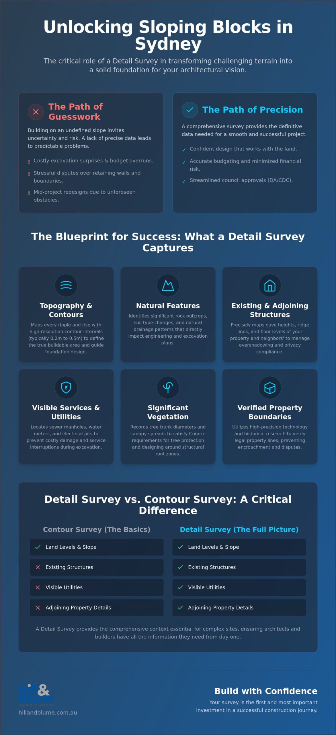
While people often use the terms interchangeably, a true detail survey is much more expansive than a simple contour plan. A contour survey might only give you the levels. In contrast, a comprehensive detail survey identifies the physical obstacles and opportunities unique to Sydney’s landscape. This includes mapping significant rock outcrops, existing vegetation, and the exact height of a neighbor’s ridge line to manage overshadowing concerns. At Hill & Blume, we believe that depth of data is the only way to ensure architectural integrity. By documenting these features early, your design team can work with the land rather than against it. You can explore our full range of Detail and Level Surveys and other specialized services to see how we approach these complex sites.
Ultimately, the detail survey provides the granular data needed to minimize construction risk. It’s about more than just height; it’s about context. When your architect understands the exact location of a sewer manhole or the drip line of a protected tree, they can design with confidence. This prevents the heart-wrenching moment when a project must be redesigned mid-excavation because an unforeseen obstacle was uncovered. On a sloping Sydney block, your survey is your first and most important investment in a smooth construction journey.
Essential Data Captured for Steep Site Development
Building on a steep Sydney site requires a level of detail that standard surveys simply can’t provide. When you’re managing the significant gradients of the Northern Beaches or the Eastern Suburbs, securing a comprehensive detail survey for sloping block sydney becomes a matter of structural necessity. It isn’t just about where the fence stands; it’s about how the land behaves. We meticulously map existing structures, including the precise levels of eaves, ridges, and floor levels, to give your architect a true 3D canvas. The precision we apply follows the rigorous standards found in resources like the Australian Soil and Land Survey Field Handbook, ensuring every measurement is scientifically sound and legally robust.
Our process also captures the physical risks inherent to Sydney’s unique topography. This includes identifying natural drainage patterns and potential soil stability issues that could compromise a foundation if not addressed during the design phase. We provide a granular look at the site by documenting:
- Significant Trees: We record trunk diameters and canopy spreads to satisfy Council requirements and protect structural root zones.
- Visible Services: Locating sewer manholes, water meters, and electrical pits prevents costly surprises during deep excavation.
- Natural Features: Mapping rock outcrops and changes in soil type that influence engineering requirements.
The Impact of Neighboring Structures
Your home doesn’t exist in a vacuum. On a slope, what happens next door directly affects your building envelope. We measure the height and position of adjacent windows and roofs to help you navigate privacy and overshadowing constraints early. This proactive approach identifies potential neighbor disputes before they happen. We also locate existing retaining walls on or near the boundary, as their structural integrity is often the linchpin of your own site’s stability. Understanding these external factors is as important as mapping your own land.
Identifying Physical and Legal Constraints
Legal boundaries often feel abstract until they meet a physical slope. We map easements and covenants that might restrict your footprint, ensuring you don’t design a masterpiece on land you can’t build on. By locating underground utilities and comparing them to the legal boundary, we provide a clear map of the risks involved in your excavation. If you’re ready to see how your site’s unique features can be mapped with precision, you can reach out to our team for a tailored consultation. This clarity allows for a seamless transition from the drawing board to the first day of construction.
Navigating Sydney Council Requirements for Sloping Sites
Sydney councils are notoriously protective of their skylines and the character of their local streetscapes. When you submit a Development Application (DA) or seek a Complying Development Certificate (CDC), you aren’t just presenting an aesthetic design; you’re making a legal claim about how that design interacts with the physical world. A precise detail survey for sloping block sydney is the only way to validate these claims. It provides the baseline for “Ground Level (Existing)”, a technical term found in Local Environmental Plans (LEPs) across the city. This measurement is the literal foundation for calculating building height limits. Without it, you risk a refusal or a costly order to modify a structure that has already been framed.
Beyond height, your survey data informs the essential Stormwater Management and Soil Erosion plans. Sydney’s topography demands a sophisticated approach to water runoff, especially on inclines where gravity accelerates the impact of every rain event. High-accuracy data allows hydraulic engineers to design systems that protect your property and your neighbor’s land, meeting council’s stringent environmental standards. By identifying the exact contours of the site, we help you avoid the hidden costs of inadequate drainage that often plague steep developments. This level of foresight is what distinguishes a well-planned project from one fraught with regulatory delays.
Building Height and Floor Space Ratio (FSR)
In the competitive world of Sydney real estate, every square meter of potential floor space counts. Using accurate levels allows you to maximize your building envelope within Council restrictions without fear of “over-height” violations. These violations can lead to stop-work orders and significant legal fees that can easily exceed the initial cost of the survey. This is why engaging a registered surveyor is non-negotiable. Only a registered professional can provide the certified documentation that councils trust, ensuring your project moves through the approval process with the calm confidence it deserves.
Retaining Walls and Excavation Limits
Sydney’s planning regulations are particularly specific about earthworks. In NSW, any retaining wall exceeding 1 meter in height typically requires formal approval and an engineered design. Similarly, CDC pathways often limit cut-and-fill operations to a maximum of 1 meter from the natural ground level. Comprehensive contour and detail surveys provide the evidence needed to justify these necessary excavations. By documenting the existing terrain with precision, you safeguard your project against structural failure and ensure your retaining walls are both compliant and perfectly integrated into the landscape. This thorough documentation is an essential part of a detail survey for sloping block sydney, providing the clarity needed to satisfy council planners and neighbors alike.
The Surveying Process: What Homeowners Should Expect
Embarking on a construction project on one of Sydney’s iconic hillsides is an exercise in vision and patience. The physical journey begins with a meticulous site visit where our surveyors utilize advanced total stations and GPS technology to capture high-accuracy data. When performing a detail survey for sloping block sydney, we don’t just look at the surface. We immerse ourselves in the land’s geometry. This fieldwork is followed by extensive research into historical records and Deposited Plans (DP) to verify boundaries that may have been established decades ago. This dual approach ensures that the digital map we create is anchored in both physical reality and legal certainty.
To complement traditional ground-based measurements, aerial data collection can provide a comprehensive view of complex sites; you can learn more about Professional Drone Imagery Pty Ltd (PDI) to see how drone technology supports high-accuracy topographic analysis.
Once the field data is collected, it undergoes a rigorous processing phase. We translate thousands of individual points into a comprehensive CAD or PDF plan tailored specifically for your architect’s software. This document becomes the master reference for your entire project team. While every site is unique, the timeline from your initial inquiry to the final delivery of the survey report typically reflects the complexity of the terrain and the depth of research required. We prioritize accuracy over speed, ensuring that every contour and boundary line is beyond reproach before it reaches your hands.
Preparing Your Sloping Block for Survey
To ensure the highest level of precision, a bit of groundwork is often required before we arrive. Clearing heavy scrub or debris is essential for maintaining clear line-of-sight measurements between our instruments. Access is the second pillar of a successful survey. Our teams may need to traverse steep embankments or rocky outcrops that define your property’s character. If your project involves shared features like retaining walls or fences, we recommend a courtesy word with your neighbors. This collaborative spirit often smooths the way when we need to measure features that sit right on the boundary line.
The Value of Professional Land Surveying Fees
It is a common misconception that all surveys are created equal. A sloping block inherently requires more time, specialized equipment, and a higher degree of technical expertise than a flat residential lot. The investment you make now represents a significant long-term cost saving. By identifying potential issues before the first shovel hits the ground, you avoid the nightmare of architectural redesigns or structural errors during the build. Understanding the various surveying services available allows you to choose a path that adds genuine value and security to your property. If you are ready to begin this journey with a partner who values quality as much as you do, please contact our team to discuss your specific site requirements.
Why Hill & Blume is the Choice for Sydney’s Most Challenging Sites
Hill & Blume is more than a surveying firm; we’re a part of the local fabric. With over 90 years of experience navigating the unique topography of Sydney and the Northern Beaches, we’ve seen how the city’s residential landscape has evolved. Our team understands that a detail survey for sloping block sydney is a high-stakes endeavor. It requires a level of care that can’t be found in high-volume, clinical agencies. We’ve built our reputation on a boutique approach that prioritizes the depth of our relationships and the absolute precision of our data. When you work with us, you aren’t just another project on a spreadsheet. You’re a partner in a curated experience designed to protect your investment and your peace of mind.
Our history gives us a distinct advantage. We possess a deep understanding of historical land records and deposited plans that many newer firms simply haven’t encountered. This legacy of trust is why Sydney’s leading architects and builders consistently choose to integrate our data into their most ambitious designs. They know that a Hill & Blume survey is a seal of quality. We take pride in ensuring that every measurement we provide serves as a reliable foundation for your architectural vision, ensuring that the transition from paper to property is as seamless as possible.
A Legacy of Trust in Sydney Surveying
Our historical knowledge isn’t just about looking backward. It’s about using that context to benefit modern developers who are pushing the boundaries of what’s possible on steep terrain. The Hill & Blume promise is one of unwavering integrity. We believe that quality should never be sacrificed for speed, especially when dealing with the complexities of Sydney’s sandstone ridges. For those who are still in the early stages of their journey, we recommend reading our guide on choosing a surveyor in Sydney. It offers a transparent look at what you should expect from a professional partnership in 2026.
Next Steps for Your Sloping Block Project
The path to a successful build on a challenging site is paved with accurate data and expert advice. Before you finalize your design or commit to a construction schedule, consult with our registered surveyors. We can provide a tailored quote that accounts for your specific site conditions, from the density of the vegetation to the severity of the incline. This early conversation ensures that your detail survey for sloping block sydney captures exactly what your project needs to succeed. If you’re ready for a partner-oriented surveying experience that respects both your time and your intelligence, please contact Hill & Blume today. We look forward to helping you unlock the full potential of your property.
Laying the Foundation for Your Sydney Vision
Designing a home on a hillside is an act of transformation. You’ve seen how a precise detail survey for sloping block sydney acts as the vital link between an ambitious architectural concept and the rigorous demands of local Council planning. By mapping every contour, tree, and service with absolute clarity, you eliminate the guesswork that often leads to excavation surprises and regulatory delays. It’s about ensuring your project respects the unique topography of our city while maximizing the potential of your land.
Beyond the construction phase, the topography of these sites often encourages an active lifestyle. For those who take advantage of the local hills for cycling, you can visit Bikeline to find the right equipment, such as high-performance pumps, to keep your gear in top condition.
With over 90 years of Sydney surveying expertise, Hill & Blume provides the calm confidence you need for such a high-stakes development. Our Registered Land Surveyors utilize sophisticated technology for high-accuracy steep-site mapping, ensuring every measurement is legally robust and design-ready. We’re here to ensure your journey from the first site visit to the final build is as seamless as the lifestyle you’re creating. Secure your project’s foundation with a Hill & Blume Detail Survey and take the first step toward a home that truly belongs to its landscape. Your vision deserves nothing less than perfection.
Frequently Asked Questions
Do I need a detail survey if I already have a title deed?
Yes, you definitely need a new survey for any development. A title deed only confirms legal ownership and basic dimensions; it doesn’t provide the topographical data or elevation levels required for architectural design. To secure Council approval on a slope, you must provide a current detail survey for sloping block sydney that reflects the physical reality of the land today.
How long does a detail survey take for a steep sloping block in Sydney?
The timeline typically ranges from one to two weeks from the initial site visit to the delivery of the final plans. While the physical measurement on a steep site might take a full day depending on vegetation, the meticulous processing of data and historical research requires additional time. We prioritize precision to ensure your architect has a flawless foundation to work from.
Why is a detail survey more expensive for a sloping site than a flat one?
Sloping sites demand a significantly higher density of data points to map contours accurately. Our surveyors must navigate difficult terrain, often dealing with heavy scrub or rock outcrops that require specialized equipment and more time on-site to maintain clear line-of-sight. This extra effort is what ensures your building footings are designed correctly the first time.
Can an architect design my home without a contour and detail survey?
Designing without a survey is a high-risk strategy that most professionals will avoid. An architect needs to know the exact “Ground Level (Existing)” to calculate building height limits and Floor Space Ratio (FSR) correctly. Without this data, you risk creating a design that is either structurally impossible to build or destined for a Council refusal.
Does a detail survey include the location of underground pipes and cables?
A standard survey identifies all visible service indicators, such as sewer manholes, water meters, and electrical pits. While we map these surface features with precision, locating the exact path of deep underground utilities often requires specialized scanning. We use the visible data to provide a clear indication of where services enter and exit your property.
Will the surveyor need to enter my neighbor’s property?
Often, yes, access to neighboring land is necessary to capture ridge heights or the position of adjacent windows. These measurements are vital for managing overshadowing and privacy concerns in your DA submission. We always recommend that you have a brief, friendly conversation with your neighbors before our team arrives to ensure the process remains smooth and respectful.
What is the difference between a detail survey and a boundary survey?
A boundary survey purely defines the legal limits of your land. In contrast, a detail survey for sloping block sydney includes those boundary lines plus all internal features, such as trees, existing structures, and contour levels. It provides the three-dimensional context that is essential for any construction project on Sydney’s challenging coastal or hilly terrain.
How often should a detail survey be updated for a Sydney property?
You should consider an update if your existing survey is more than two years old or if any physical changes have occurred on the site. Councils often require the most current data to ensure that new developments account for any recent changes to neighboring structures or landscaping. A fresh survey ensures your design is based on the most accurate, up-to-date information available.
Disclaimer
The information provided in articles published on this website is for general informational purposes only. While we make every effort to ensure the accuracy, completeness, and timeliness of the content, the material is based on our understanding of the industry at the time of writing and may not reflect the most current developments, regulations, or standards. All opinions expressed in our articles are those of the respective authors and do not necessarily represent the official position of the website or its affiliates. The content should not be considered professional, legal or technical advice, and should not be relied upon as a substitute for consultation with qualified professionals