

Your architect’s vision is only as strong as the ground it’s built upon. Without a precise digital map, even the most elegant design remains a beautiful gamble. You likely feel the weight of Sydney’s evolving planning landscape, where the pressure to meet strict Council DA requirements can turn a dream project into a maze of compliance. It’s a common anxiety to fear that inaccurate site data might lead to expensive redesigns or frustrating delays. We understand that you value quality and precision, seeking a partnership that respects both your time and your investment.
A professional topographic survey acts as the essential bridge between your raw site and a design-ready reality. By capturing every nuance of your land under the Surveying and Spatial Information Regulation 2024, we ensure your project begins on a foundation of absolute certainty. This article explores how a precise survey secures your DA approval and provides the CAD-ready data your design team requires. You’ll discover the distinction between different survey types and learn why local expertise is your greatest asset in 2026.
Key Takeaways
- Discover how a precise 3D representation of your land serves as the vital first step toward securing a seamless Council approval process.
- See how a topographic survey captures every delicate nuance of your site, from significant trees to structural features, ready for your architect’s vision.
- Learn why accurate site data is the most effective way to eliminate the risk of costly redesigns or unexpected surprises during the excavation phase.
- Explore the refined process of turning raw field data into a polished CAD file that simplifies your entire design and construction journey.
- Understand the essential role of a Registered Surveyor in ensuring your project is anchored by legal integrity and professional craftsmanship.
What is a Topographic Survey? Defining the Foundation
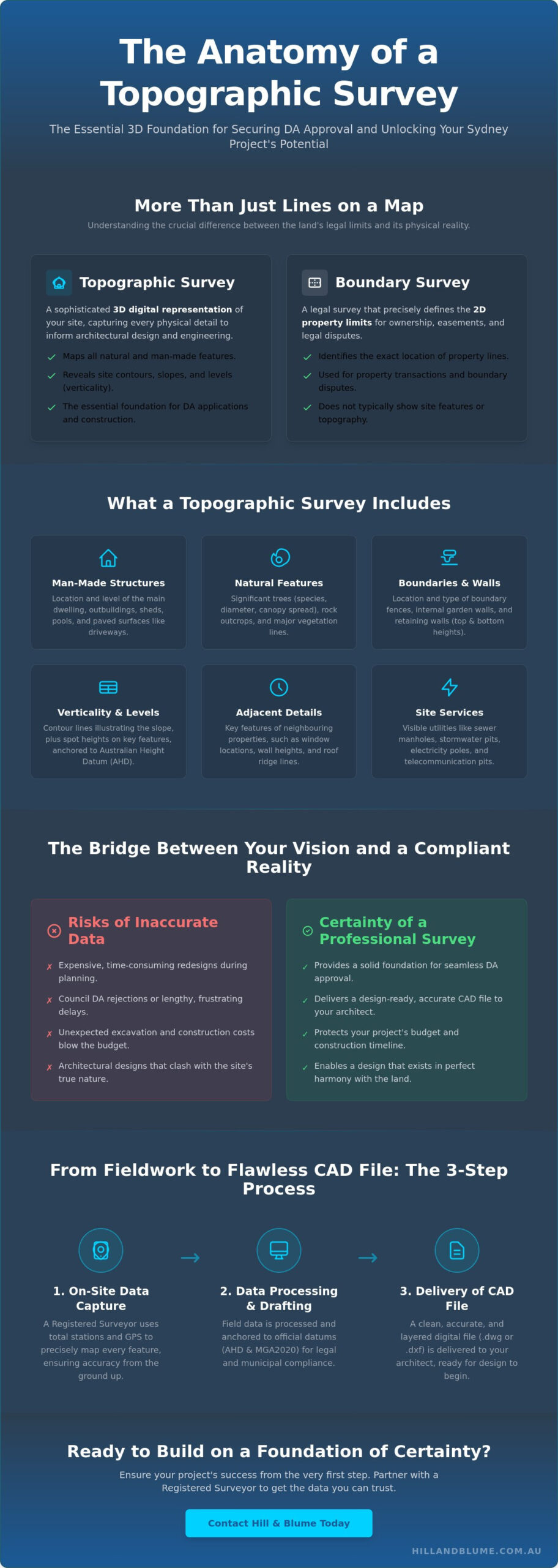
Before the first brick is laid or the first beam is placed, your project requires a deep understanding of the earth it will inhabit. A topographic survey is much more than a simple drawing of property lines; it is a sophisticated 3D representation of your site’s unique character. It captures every man-made structure and natural element, from the graceful curve of a sandstone outcrop to the precise position of a neighbor’s balcony. While a boundary survey defines the legal limits of your ownership, the topographic survey explores the space within, focusing on the rises, falls, and features that will dictate your architectural possibilities. Think of it as the first, essential conversation between the land and your architect.
This survey transforms the physical world into a design-ready digital canvas. By mapping the three-dimensional coordinates of your property, we provide your design team with the clarity they need to work with confidence. It’s about more than just avoiding mistakes; it’s about unlocking the hidden potential of a site. Whether you’re working with a narrow terrace in Paddington or a sprawling coastal lot in Vaucluse, the topographic data reveals opportunities that a flat map simply cannot see. It is the difference between a design that fights the landscape and one that lives in harmony with it. In Sydney, this data must be anchored to the Australian Height Datum (AHD). This universal reference point ensures your levels align perfectly with municipal infrastructure and neighboring properties, a non-negotiable requirement for local compliance.
The Role of Verticality and Levels
In a city as geographically diverse as Sydney, the slope of your block is often its most defining feature. We use contour lines to illustrate this verticality, painting a digital picture of how the land rolls and dips. This isn’t just for aesthetic planning. Accurate height data is the heartbeat of structural integrity. It informs how water will flow across your site and where drainage must be positioned to protect your future home. To achieve this, we utilize geodetic coordinates to MGA2020 standards. This level of modern precision ensures that every data point we collect is placed exactly where it exists in the real world, providing a seamless transition from our field equipment to your designer’s screen.
Topographic Survey vs. Detail and Level Survey
You may find that different professionals use varied terminology for the same essential service. In New South Wales, the terms “topographic survey” and Detail and Level Survey are frequently used interchangeably during the pre-construction phase. Both aim to provide the comprehensive data set required for a successful Development Application. Your architect might also request a feature survey if they are particularly focused on specific site elements like significant trees or existing stone walls. Regardless of the label, the goal remains the same: to create a precise digital canvas that honors the land while fulfilling the rigorous standards of your local council.
What Does a Topographical Survey Include? The Anatomy of the Map
A topographic survey is a meticulously crafted inventory of every element that shapes your property. It doesn’t just show you where things are; it describes how they exist in relation to one another. You’ll find a detailed record of man-made structures such as the main dwelling, outbuildings, and paved surfaces. These details provide the practical applications for construction that your builder will rely on when calculating materials and site access. By documenting these features with precision, we transform a physical site into a reliable digital asset.
The anatomy of a comprehensive survey typically includes:
- Existing residential and secondary structures
- Driveways, paths, and paved surfaces
- Retaining walls, including top and bottom heights
- Boundary fences and internal garden walls
Natural and Man-Made Features
In our lush Sydney suburbs, the natural landscape is often as protected as the heritage architecture. Your survey will map significant trees, noting their species, trunk diameter, and the full reach of their canopy spread. This level of detail is a standard Council requirement for any development application. We also document rock outcrops and water bodies that might influence your foundation design. For existing buildings, we capture floor levels and ridge heights, helping you decide which elements to retain and which to transform during your renovation.
Infrastructure and Utility Mapping
The invisible threads of urban life are woven throughout your land. We identify and map visible service indicators like sewer manholes, stormwater pits, and power poles. Locating these markers early prevents costly delays during excavation and ensures your design respects any existing easements or encumbrances. This data seamlessly integrates with your broader site survey requirements, providing a holistic view of the constraints and opportunities beneath the surface.
We extend our gaze beyond your boundaries to include critical information from adjoining properties. Understanding the window placements and roof heights of your neighbors is essential for privacy and overshadowing analysis. This foresight is a hallmark of a well-prepared DA, demonstrating to Council that your project is a thoughtful addition to the streetscape. A professional topographic survey ensures that your design process is grounded in reality rather than assumption. If you’re ready to see your site with this level of clarity, we invite you to reach out for a tailored consultation.
Why a Topographic Survey is Critical for Sydney Development
Sydney’s landscape is a masterpiece of complexity. From the dramatic coastal cliffs of the Eastern Suburbs to the rolling hills of the North Shore, your land possesses a rhythm that must be respected. A topographic survey serves as more than a mere map; it’s a vital safeguard for your investment. In a city where every millimeter of height and every degree of slope can influence your building envelope, relying on outdated or imprecise data is a risk few can afford. We view this survey as a tool for absolute clarity, ensuring that your boutique project remains protected from the hidden costs of the unknown.
Navigating Council and CDC Requirements
Most Sydney local government areas maintain rigorous standards for Development Applications. You’ll likely find that your local Council requires a survey completed within the last two years to ensure current site conditions are reflected. This data is the backbone of overshadowing studies and view loss assessments, two of the most sensitive hurdles in the Sydney planning process. Whether you’re pursuing a traditional DA or a streamlined Complying Development Certificate (CDC) pathway, the precision of your topographic data determines how smoothly your project moves through the approval phase.
The Cost of Inaccuracy: Avoiding Redesign
The true value of precision often reveals itself when it’s missing. Imagine a scenario where a slight error of 200mm in ground level leads to an entire roofline exceeding the Council’s height limit. Such a mistake doesn’t just cause a delay; it forces a total architectural redesign and a fresh round of approvals. This is why the accuracy of your initial data is paramount. The success of the eventual construction set out relies entirely on these early measurements. At Hill & Blume, our 90-year legacy in the Sydney region provides a level of data integrity that protects your vision from these avoidable setbacks. We believe that your project deserves a foundation built on decades of local expertise and a commitment to detail that mirrors your own high standards.
The Process: From Fieldwork to Architectural CAD
Creating a topographic survey is a journey that begins long before we step onto your property. It’s a process defined by a blend of historical research and cutting-edge technology, ensuring the final result is as accurate as it is elegant. We start by examining title records and existing survey plans to understand the legal and physical context of your land. This research provides the framework for our on-site work, allowing us to approach your project with a comprehensive understanding of its history and its boundaries.
The transition from a physical site to a digital model involves four distinct stages:
- Initial Research: Investigating NSW title records and historical data to establish a baseline of existing information.
- On-Site Collection: Using Total Stations and GPS technology to capture precise spatial coordinates and levels.
- Data Processing: Translating field measurements into a sophisticated Digital Terrain Model (DTM) within our studio environment.
- Quality Assurance: A final, rigorous review by a Registered Surveyor to certify every detail before delivery.
On-Site Precision and Technology
When our team arrives at your property, you’ll see the quiet, deliberate use of high-precision equipment. We utilize Total Stations and GPS technology to capture “spot levels” across your site. These points are the building blocks of your contour map, illustrating every rise and fall of the terrain. Even on sites with dense vegetation or challenging coastal access, our experience allows us to gather data without compromising on accuracy. We treat your land with care; we ensure that every significant feature is documented with the precision your project demands, regardless of the terrain’s complexity.
Digital Deliverables for Your Design Team
The final stage of our work is the delivery of a “clean” CAD file, typically in DWG format, alongside a detailed PDF for your records. This digital canvas is designed for seamless integration into your architect’s workflow. While some projects only require a 2D representation, many of our boutique clients opt for 3D survey outputs. This allows for more complex modeling and a better visualization of how a new structure will sit within the existing landscape. A well-organized, clutter-free file saves your design team hours of technical adjustments, allowing them to focus entirely on the creative vision.
A professional topographic survey is the bridge between a raw site and a finished masterpiece. We pride ourselves on delivering data that isn’t just technically correct, but also effortless for your team to use. If you’re ready to transform your site into a design-ready asset, we invite you to start a conversation with our team today.
The Hill & Blume Difference: Why Choose a Registered Surveyor?
In New South Wales, the law is clear: only a Registered Surveyor can provide the certified data required for boundary-related matters and complex development. When you commission a topographic survey, you aren’t just buying a set of measurements; you are investing in legal certainty and professional integrity. We approach every site with a sense of stewardship, recognizing that your property is a significant part of your lifestyle and legacy. Unlike high-volume firms that treat surveying as a clinical transaction, we prioritize the depth of our relationship with you. This partnership ensures that your aspirations remain at the heart of our technical work.
Expertise Rooted in Sydney’s History
Our story began in 1932. For over 90 years, Hill & Blume has been an essential part of the local fabric, documenting the evolution of Sydney, Newcastle, and the Central Coast. This deep archive of historical data often proves invaluable for modern projects, allowing us to resolve complex site puzzles that younger firms might miss. Our established relationships with local authorities help streamline the planning process, providing a sense of calm confidence as you move toward approval. We invite you to explore our full range of surveying services to see how this legacy of craftsmanship can support your vision.
A Boutique, Professional Partnership
We choose to remain a boutique agency because we value quality over quantity. This allows us to provide a hand-crafted service feel that larger corporate entities simply cannot replicate. Every communication we share is purposeful and clutter-free, mirroring the seamless service we aim to provide on-site. You’ll find that our team acts as a specialized local authority, offering a refined aesthetic and a personal touch that respects your time and intelligence. Whether you’re planning a coastal retreat or a sophisticated urban renovation, we ensure your project is built on accurate, certified data. We encourage you to reach out for a tailored consultation to discuss the unique characteristics of your site.
Building Your Vision on a Foundation of Certainty
Every great Sydney project begins with a moment of clarity. You now understand how a precise topographic survey transforms a physical site into a design-ready asset, ensuring your architectural vision is anchored in reality. By mapping every level and feature with meticulous care, you eliminate the risk of costly redesigns and navigate the complexities of Council DA requirements with ease. It’s about more than just data; it’s about the confidence that comes from knowing your project is built on a foundation of absolute accuracy.
At Hill & Blume, we bring over 90 years of Sydney surveying expertise to your site. As Registered Land Surveyors with full NSW certification, we specialize in high-end residential and commercial developments where precision is paramount. We invite you to partner with Hill & Blume for your next project and experience a boutique service that values your aspirations as much as you do. Your site deserves the care and craftsmanship that only a dedicated local authority can provide. Let’s ensure your journey from initial concept to final construction is seamless and inspired.
Frequently Asked Questions
Do I need a topographic survey, or will a basic site plan do?
A professional survey is essential for any project involving structural changes or local council approval. A basic site plan typically lacks the vertical data and precise feature mapping required by Sydney councils for a successful Development Application. Without this 3D data, your architect cannot accurately assess drainage, overshadowing, or foundation requirements, which often leads to costly delays.
How much does a topographic survey cost in NSW?
The investment for a professional survey is influenced by the complexity of your terrain, the density of vegetation, and the size of your lot. While every site is unique, engaging a Registered Surveyor ensures you receive certified data that protects your project from expensive redesigns. We recommend requesting a tailored consultation to ensure the scope of work aligns perfectly with your architect’s specific design requirements.
How long does the topographic survey process take from start to finish?
You can typically expect the process to take between one and two weeks from the initial site visit to the delivery of your digital CAD files. This timeframe allows for meticulous on-site data collection followed by rigorous studio processing and quality assurance. Larger or more complex sites may require additional time to ensure every nuance of the land is captured with absolute precision.
What is the difference between a topographic survey and a contour survey?
These terms are often used interchangeably in the Sydney development industry, though a topographic survey is generally more comprehensive. While a contour survey focuses primarily on the slope and levels of the land, a topographic map includes all natural and man-made features. This includes significant trees, existing structures, and visible utility markers that are vital for modern design.
Can my architect use a topographic survey for the construction set-out?
Your architect uses the topographic data to design your project, but a separate construction set-out is required once building begins. This ensures the physical structure is placed exactly where the approved plans intend. While the initial survey provides the digital canvas for your vision, the set-out is the final act of precision that translates those designs onto the earth.
Will one topographic survey cover everything I need for my DA?
A comprehensive survey usually satisfies the primary site data requirements for a Development Application, but you should always verify specific council checklists. Some projects may require additional specialized plans, such as a formal Boundary Survey or a Detail and Level Survey, to address specific legal or structural concerns. We ensure our digital deliverables are structured to meet these rigorous standards seamlessly.
Disclaimer
The information provided in articles published on this website is for general informational purposes only. While we make every effort to ensure the accuracy, completeness, and timeliness of the content, the material is based on our understanding of the industry at the time of writing and may not reflect the most current developments, regulations, or standards. All opinions expressed in our articles are those of the respective authors and do not necessarily represent the official position of the website or its affiliates. The content should not be considered professional, legal or technical advice, and should not be relied upon as a substitute for consultation with qualified professionals