

Imagine standing on your sun-drenched lawn, only to realize your neighbor’s new fence is creeping into your private sanctuary. It’s a tiny distance that creates a massive rift in the harmony of your home life. You’ve likely spent years dreaming of your property’s potential, yet the fear of a legal dispute or a rejected Development Application keeps you from moving forward with confidence. When you engage a qualified boundary surveyor, you replace that uncertainty with the calm confidence that your land is protected. It’s natural to feel anxious when the lines between your vision and the law seem blurred, especially with the complexities of modern property regulations.
This guide will show you how to secure your property rights and provide the technical precision your construction project demands. You’ll discover how the Surveying and Spatial Information Regulation 2024 has elevated standards for accuracy, ensuring your plans meet the 95% confidence interval required for seamless approval. We’ll walk through the essential steps to distinguish a registered professional from a general measurer, giving you the legal certainty and peace of mind you deserve before you invest in your home’s future.
Key Takeaways
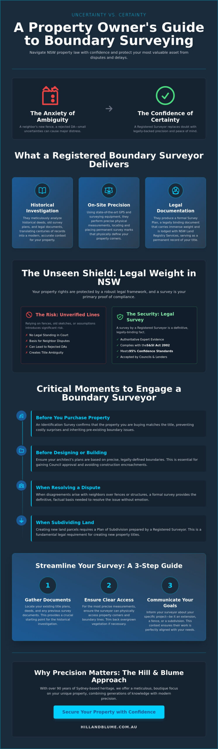
- Learn how a registered boundary surveyor preserves the integrity of your land by expertly translating complex historical deeds into tangible, physical certainty.
- Understand the legal framework of the Surveying and Spatial Information Act 2002 and why a formal survey acts as a premium seal of quality for your property title.
- Identify the essential stages for professional involvement, ensuring your property lines are verified before you commit to a purchase or begin the design process.
- Streamline your project with simple preparation steps, from locating existing title plans to ensuring clear access for precise site measurements.
- Discover the value of a partnership-oriented approach that combines ninety years of Sydney-based heritage with a meticulous, boutique focus on your unique property.
What Does a Boundary Surveyor Do for Your Property?
Your property is more than just a piece of land; it is a sanctuary and a significant part of your legacy. Yet, the peace of mind you feel in your home relies on a silent, invisible foundation: the legal certainty of your property lines. A boundary surveyor is a highly trained professional authorized by the state to provide the definitive answer to where your land begins and ends. Their work isn’t merely about measuring distances. It’s about the meticulous translation of historical deed descriptions and complex legal documents into physical, tangible marks on your land.
In the high-stakes Sydney property market, “near enough” is never good enough. A discrepancy of just a few centimeters can be the difference between a seamless home extension and a distressing legal dispute with a neighbor. To truly understand what surveying is, one must view it as a sophisticated blend of high-level mathematics, historical detective work, and advanced technology. It’s a specialized discipline designed to protect your property rights and ensure your investments remain secure for generations to come.
The Role of a Registered Land Surveyor
In New South Wales, the law is incredibly specific: only a Registered Surveyor can legally define or re-establish property boundaries. This registration represents years of rigorous university study, practical training, and a deep commitment to the ethical standards set by the Board of Surveying and Spatial Information (BOSSI). When you choose a partner for this task, you’re looking for more than a technician; you’re looking for a steward of your property’s value. The Hill & Blume 90-year legacy reflects this level of dedication, offering a boutique experience that prioritizes the depth of our relationship with you over high-volume turnover.
The Difference Between a Sketch and a Legal Survey
You might be tempted to rely on an old fence line or a hand-drawn sketch found in your purchase documents. These are often unreliable indicators of your true title. Fences move over decades, and sketches lack the legal weight required for modern construction or Council approvals. A professional boundary surveyor uses sophisticated GPS technology and centuries of historical data to re-establish lines with absolute certainty. Relying on unverified measurements for a major investment is a risk that simply doesn’t align with a refined, well-planned lifestyle. True precision comes from a formal survey, providing a “seal of quality” that unverified sketches can’t match.
Understanding the Legal Weight of a Boundary Survey in NSW
The legal framework in New South Wales is remarkably robust. It ensures that every centimeter of your land is accounted for under the Surveying & Spatial Information Act 2002. This legislation isn’t just a set of rules for professionals; it’s your primary shield against property ambiguity. When a boundary surveyor conducts an identification survey, they’re providing a document that carries immense legal weight. It serves as a definitive seal of quality that reassures banks, insurers, and future buyers that your property’s physical reality aligns perfectly with its legal title.
This legal standing is what allows a surveyor to act as a definitive expert witness. Should a dispute ever reach a courtroom, the findings of a registered professional are the only ones recognized as authoritative. This status transforms a simple site measurement into a powerful instrument of protection. It’s the difference between having an opinion about your land and having a legally binding fact that stands up to scrutiny.
Compliance and the Role of Land Registry Services
Every professional survey plan is designed to endure for generations. These documents are lodged with the NSW Land Registry Services (LRS), forming part of the state’s permanent record. Whether it’s a Plan of Subdivision or a Redefinition, these records follow the strict legal principles of boundary definition to ensure consistency across the Sydney basin. A registered plan acts as a permanent safeguard that anchors your property equity to a verified, unchangeable legal coordinate. This digital and physical trail ensures that the legacy you build on your land remains unquestioned by future developments.
Protecting Your Investment from Encroachments
An encroachment occurs when a neighbor’s structure, such as a garage, retaining wall, or even a simple fence, crosses your property line. These issues often go unnoticed for years, only surfacing during a sale or a major renovation. A boundary surveyor identifies these overlaps with surgical precision before they escalate into exhausting legal battles. Professional boundary surveys are the first line of defense in maintaining the integrity of your estate. By resolving these discrepancies early, you preserve the harmony of your local lifestyle and the financial value of your land. If you’re planning a new project or simply want to confirm your land’s true extent, it’s helpful to speak with a professional who understands the unique nuances of your local area.
When Should You Engage a Boundary Surveyor?
Timing is everything when it comes to preserving the value and tranquility of your home. Engaging a boundary surveyor isn’t just a reactive measure for when things go wrong; it’s a proactive step that sophisticated homeowners take at pivotal moments in their property’s life cycle. Whether you’re standing on the cusp of a new purchase or envisioning a grand architectural redesign, having a clear understanding of your land’s physical limits ensures your plans are built on a foundation of absolute truth. Acting early prevents the friction that often arises when assumptions meet the reality of the law.
There are several critical milestones where professional survey work becomes essential:
- Prior to purchasing: You wouldn’t buy a masterpiece without verifying its provenance. A survey ensures the land you’re acquiring matches the title perfectly, protecting you from inheriting a neighbor’s encroachment.
- Before commencing design: Architects require more than just a footprint. They need a contour and detail survey alongside boundary markers to ensure your vision fits within legal setbacks and height limits.
- During fencing renewals: Replacing a boundary fence is the perfect time to confirm the line. It provides an objective, third-party resolution that keeps neighborly relationships intact.
- Subdividing land: Unlocking the potential of your block requires a mandatory subdivision survey to create new legal titles recognized by the state.
Navigating the Sydney DA and CDC Process
In the intricate landscape of Sydney’s local councils, a current survey is often the first document requested. Whether you’re pursuing a formal Development Application (DA) or a faster Complying Development Certificate (CDC), precision is non-negotiable. Councils require these plans to verify that your proposed work respects the privacy and space of the surrounding community. By securing a boundary surveyor early in the planning phase, you avoid the frustration of “stop-work” orders or costly redesigns that occur when unverified site plans are rejected. It’s about ensuring a seamless transition from your initial sketch to the first day of construction.
Resolving Boundary Disputes with Grace
Disagreements over property lines can feel deeply personal, but they don’t have to be confrontational. A professional survey provides a neutral, evidence-based perspective that de-escalates tensions between neighbors. By following the official NSW guidelines for boundary determinations, a surveyor acts as a calm authority who values community harmony as much as technical accuracy. An identification survey report offers a clear, written record of any discrepancies, allowing all parties to move forward with clarity. This measured approach transforms a potential conflict into a shared understanding, preserving the local lifestyle you’ve worked so hard to cultivate.
How to Prepare for Your Boundary Survey: A Step-by-Step Guide
Preparing for a professional survey is a collaborative journey. While your boundary surveyor brings technical expertise and historical insight, your local knowledge of the property serves as a vital starting point. A well-prepared site ensures the process remains seamless, allowing the survey team to focus on the high-precision work that defines your property’s legal limits. By following a few deliberate steps, you contribute to a more efficient and accurate outcome for your home.
- Step 1: Locate your history. Gather any existing title documents, previous survey plans, or old deeds. Even hand-drawn sketches from decades ago can provide clues that assist the professional in their initial assessment.
- Step 2: Clear the path. High-precision optical equipment requires a clear line-of-sight. Removing heavy vegetation, debris, or stored materials near the corners and along the boundary lines allows for unobstructed measurements.
- Step 3: Foster transparency. Notify your neighbors of the upcoming survey. A simple conversation ensures they aren’t surprised by the presence of a survey team and helps facilitate access to shared boundary lines.
- Step 4: Define your vision. Be specific about your goals. If you’re planning a pool on the northern side or a new retaining wall, sharing these details helps the surveyor prioritize the data that matters most to your project.
- Step 5: Review the findings. Once the field work is complete, sit down with your surveyor to review the Identification Report. This document is the definitive biography of your land’s boundaries.
Gathering Essential Property Documentation
Your personal archives are often the first piece of the puzzle. Documents such as Strata plans or old purchase contracts can offer valuable context that helps a boundary surveyor locate original boundary pegs that may have been buried over time. While your input is invaluable, the surveyor will also conduct exhaustive, independent research at the NSW Land Registry Services. This dual approach ensures that every piece of evidence, both historical and modern, is considered before a final determination is made.
Ensuring Site Access and Safety
The precision of modern surveying relies on the ability to access all corners of your land. Please ensure that gates are unlocked and pets are safely secured on the day of the visit to avoid unnecessary delays. Because surveyors use sophisticated optical and GPS technology, maintaining a clear view between points is essential. If a site is heavily overgrown or blocked by temporary structures, it can hinder the accuracy of the measurements. Taking the time to tidy these areas reflects a commitment to the quality and integrity of the final survey. If you’re ready to begin this process for your property, you can reach out to our team to discuss your specific site requirements.
Why Precision Matters: The Hill & Blume Approach
In the world of luxury real estate and bespoke construction, true value is found in the details. When you choose a boundary surveyor, you’re selecting more than just a technical consultant. You’re choosing a partner to safeguard your most precious asset and your family’s sanctuary. Hill & Blume isn’t just a firm; it’s a legacy of precision that has woven itself into the fabric of the Sydney community for nearly a century. We believe that every property has a story, and our role is to ensure its legal chapters are written with absolute clarity and unwavering accuracy.
Our approach is defined by a sense of calm confidence. We don’t rush through high-volume workloads. Instead, we prioritize the depth of our relationships, ensuring that every client feels the weight of our expertise and the warmth of our personal touch. The “Hill & Blume” name has become a seal of quality in the region, representing a curated experience that distinguishes your property from the rest. It’s a commitment to excellence that mirrors the high standards you set for your own home.
A Legacy of Excellence in Sydney and the Central Coast
Since 1932, we’ve navigated the unique and often challenging landscapes of the Sydney basin and the Central Coast. Our roots go deep into the local soil. We’ve seen our region transform over the decades, yet our commitment to traditional integrity remains anchored. This profound local knowledge is a significant asset to your project. We understand the nuances of the terrain, from the complex sandstone foundations of the harbor to the heavily vegetated slopes of the hinterland. We support architects, developers, and homeowners with a level of insight that only nine decades of specialized experience can provide. Our history isn’t just about the past; it’s the foundation upon which we build your future certainty.
Bespoke Surveying Solutions
We don’t believe in one-size-fits-all measurements. We offer bespoke surveying services tailored to the unique charm and specific requirements of your land. Every engagement begins with a considered conversation, ensuring we understand your aspirations before we ever set foot on site. We combine the meticulous craftsmanship of the past with 2026-standard surveying technology, utilizing advanced spatial data tools to deliver results that exceed modern regulatory expectations. This boutique approach ensures that your project receives the dedicated attention it deserves, moving smoothly from initial concept to final approval. It’s time to partner with experts who value your property as much as you do. Reach out to us today to secure the precision your legacy requires.
Building Your Future on a Foundation of Certainty
Protecting the integrity of your land is an act of stewardship that ensures your home remains a true sanctuary. By understanding the legal weight of a registered survey and the meticulous standards of current regulations, you move beyond guesswork and into a space of absolute clarity. Engaging a boundary surveyor is the essential first step in any property journey, whether you’re securing a new purchase or preparing for a sophisticated architectural addition. It’s about replacing the anxiety of the unknown with the calm confidence of verified facts.
Since 1932, Hill & Blume has served as a trusted authority for homeowners across Sydney, Newcastle, and the Central Coast. Our registered NSW surveyors combine nearly a century of local heritage with the precision of modern technology to deliver a boutique service that values your property’s unique story. We invite you to secure your property integrity with a professional boundary survey from Hill & Blume. Your vision deserves the precision that only a dedicated local specialist can provide; we look forward to helping you build your legacy with confidence.
Frequently Asked Questions
How much does a boundary surveyor cost in NSW for 2026?
The cost of engaging a professional boundary surveyor depends on the unique characteristics of your land, including its size, the complexity of the terrain, and the depth of historical research required. While every project is different, this investment provides the legal certainty needed to protect your property’s value and prevent the far greater expenses of construction errors or neighborly disputes. We recommend a personalized consultation to understand the specific requirements and nuances of your site.
Is a boundary survey the same as a land survey?
No, a boundary survey is a specialized legal service, while “land survey” is a broad umbrella term for many different types of measurement. Only a registered boundary surveyor has the specific authority to re-establish the legal limits of your property title. This distinction is vital when you require legally binding evidence for a property sale, a new fence, or a formal Development Application.
How long does a boundary survey take to complete?
The timeframe for a professional survey typically ranges from several days to a few weeks. This process involves a blend of meticulous on-site measurements and exhaustive research into historical records at the NSW Land Registry Services. The complexity of your land’s history and the specific documentation required by your local council will influence the final schedule for your project.
Can I use a survey from ten years ago for my new renovation?
It’s unlikely that an older survey will meet the rigorous standards required for a modern renovation or Council approval. With the commencement of the Surveying and Spatial Information Regulation 2024, measurement accuracy and reporting standards have become more demanding. Physical changes to your site or neighboring properties over a decade also mean that a fresh assessment is necessary to ensure current precision.
What happens if the surveyor finds my fence is in the wrong place?
If a discrepancy is found, your surveyor will provide an Identification Report that clearly documents the location of the fence relative to the legal boundary. This professional document serves as a neutral, factual basis for a graceful conversation with your neighbor. It allows both parties to understand the physical reality of the land, often resolving the issue before it escalates into a stressful legal conflict.
Do I need a boundary survey for a simple fence replacement?
While not always a legal requirement for every fence, a survey is highly recommended to ensure your new structure is placed correctly. Fences are long-term investments, and placing one even slightly over the line can lead to costly removal orders or disputes in the future. Confirming the line first provides the peace of mind that your home’s boundaries remain respected and secure.
Is a registered surveyor required for a strata plan in Crows Nest?
Yes, only a Registered Surveyor is authorized to prepare and certify Strata and Community Title Plans in New South Wales. Whether you’re developing a boutique complex in Crows Nest or elsewhere in the Sydney basin, this registration is a legal necessity. It ensures that the plans lodged with the state are accurate and provide a clear definition of individual ownership within the community.
Can a boundary surveyor help with an easement dispute?
A surveyor is an essential partner in resolving easement disputes by physically locating the easement’s extent on your property. By translating the legal descriptions from your title into tangible marks on the ground, they provide the objective clarity needed to understand your rights. This factual insight is often the key to reaching a fair and permanent resolution regarding access or utility rights.
Disclaimer
The information provided in articles published on this website is for general informational purposes only. While we make every effort to ensure the accuracy, completeness, and timeliness of the content, the material is based on our understanding of the industry at the time of writing and may not reflect the most current developments, regulations, or standards. All opinions expressed in our articles are those of the respective authors and do not necessarily represent the official position of the website or its affiliates. The content should not be considered professional, legal or technical advice, and should not be relied upon as a substitute for consultation with qualified professionals