
Your property’s most vital document isn’t necessarily your contract of sale; it’s the intricate, often cryptic map that defines exactly where your sanctuary ends and the rest of the world begins. For many homeowners, the process of understanding my survey report nsw feels like trying to decipher a foreign language while the security of your investment hangs in the balance. It is perfectly natural to feel a sense of unease when faced with a page of RLs, BMs, and complex easements. These technical symbols shouldn’t be a barrier between you and the peace of mind you deserve.
We believe that clarity is the foundation of a premium property experience. You’ve worked hard for your home, and you should feel empowered to read its legal narrative with absolute certainty. This guide will show you how to interpret the technical shorthand and boundary data in your report to protect your investment. We’ll walk through identifying property lines, spotting potential encroachments, and understanding how the Surveying and Spatial Information Regulation 2024 impacts your future renovations or development applications.
Key Takeaways
- Learn to distinguish between the visual Survey Plan and the technical Survey Report to ensure you have a comprehensive view of your property’s legal status.
- Discover how to interpret critical markers like easements and encroachments, providing the clarity needed to protect your land and boundary rights.
- Master the nuances of understanding my survey report nsw to confidently navigate technical symbols and avoid the pitfalls of scaling off paper plans.
- Understand why lenders and legal authorities require specific Identification Surveys to validate property boundaries during high-stakes transactions.
- Identify the clear signs that your project requires the specialized expertise of a Registered Surveyor to bridge the gap between historical data and modern requirements.
Decoding the Language: What Your NSW Survey Report Actually Is
When you receive your documentation, you’re looking at a legal narrative drafted with surgical precision. A survey report isn’t just a sketch; it is a formal instrument prepared by a Registered Surveyor to bridge the gap between what’s written in your property title and what actually exists on the ground. In the context of understanding my survey report nsw, it’s helpful to realize that these documents must adhere to strict standards set by the NSW Land Registry Services (LRS). As of March 1, 2025, the Surveying and Spatial Information Regulation 2024 has further refined these requirements, ensuring that every measurement lodged via the LRS Connect portal meets high accuracy tolerances. This rigorous framework ensures the ‘Land in the Folio’, which is your legal title, perfectly aligns with the ‘Land on the Ground’.
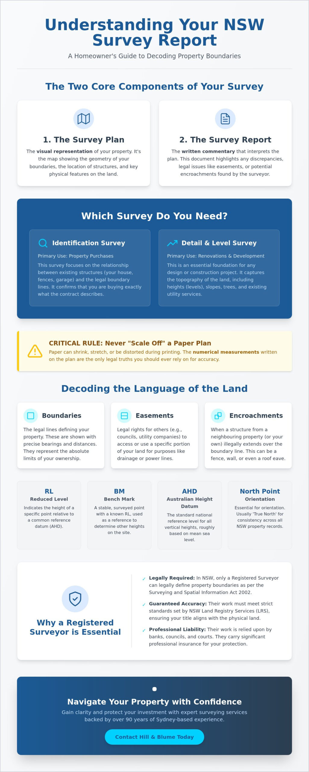
You’ll usually see two distinct components. The Survey Plan is the visual representation, showing the geometry of your boundaries and the location of structures. The Survey Report is the written commentary that interprets those drawings, highlighting any discrepancies or legal encumbrances. Together, they form a complete picture of your property rights, rooted in the long history of Surveying in Australia and the Torrens title system. This dual approach ensures that technical data is supported by professional analysis, leaving no room for ambiguity during a transaction.
Identification Surveys vs. Detail and Level Surveys
If you’re in the process of purchasing a property, you’ll likely receive an Identification Survey. This document focuses on the relationship between existing structures and the boundary lines, essentially confirming that you’re buying exactly what the contract describes. For those investing in high-end property, firms like Zed Real Estate often recommend these surveys to ensure the physical assets align perfectly with the luxury price point. In contrast, a Detail and Level Survey is the essential foundation for Sydney renovations. It captures the topography of the land, including heights, slopes, and existing features. While they serve different purposes, these documents often interact during a Development Application (DA), where council requires both a clear boundary definition and a precise map of the terrain to approve your vision.
The Role of the Registered Surveyor in NSW
In New South Wales, the law is clear: only a Registered Surveyor can sign off on boundary definitions. This isn’t just a matter of professional preference; it’s a requirement of the Surveying and Spatial Information Act 2002. These experts carry significant professional liability, as their work is relied upon by banks, councils, and the courts. At Hill & Blume, our 90-year legacy in the Sydney region provides a unique advantage. We have spent decades navigating the complex catchments and historical records of the local area, ensuring that our clients receive a level of precision that only a boutique, specialized authority can provide. When you engage with our comprehensive surveying services, you aren’t just getting a map; you’re gaining a partner dedicated to the long-term integrity of your property investment.
Reading the Plan: Symbols, Scales, and Abbreviations Explained
Opening your survey plan is the first step toward understanding my survey report nsw with total confidence. At first glance, the document may appear as a complex web of fine lines and cryptic annotations. However, every mark is a deliberate piece of data designed to protect your interests. You’ll notice a North Point, which is essential for orientation; usually, this is “True North” rather than magnetic, ensuring consistency across all NSW property records. One of the most important rules of thumb is to never “scale off” a paper plan. Paper can shrink, stretch, or be distorted during printing. The numerical measurements written on the plan are the only legal truths you should rely on.
To navigate the technical landscape, you’ll need to recognize a few key abbreviations. RL stands for Reduced Level, which indicates the height of a specific point. BM refers to a Bench Mark, a stable reference point used to determine those heights. These are all tied to the AHD, or Australian Height Datum. When researching the lineage of your land, looking into NSW Examining Survey Reports can provide historical context on how these standards were established and recorded over decades of Sydney’s development.
The “Secret Code” of Surveying Symbols
Surveyors use a specific visual shorthand to mark physical evidence found on-site. You might see small circles or crosses representing boundary pegs, drill holes in concrete, or wing marks on stone walls. It’s a common misconception that fences sit perfectly on boundary lines. In reality, fences are often slightly offset, and your plan will clearly indicate the distance between the physical fence and the legal boundary. If you’re looking at a Detail and Level Survey, you’ll also see contour lines; these elegant curves represent the “rise and fall” of your Sydney block, allowing you to visualize the slope without standing on the grass.
Measurements: Links, Feet, and Meters
If your property has a long history, you might encounter older plans using Imperial measurements like links or feet. Modern reports have transitioned to the Metric system, but a skilled surveyor can translate these historical records into contemporary data for your project. You’ll also see bearings expressed in degrees, minutes, and seconds, which define the precise angle of your boundary lines. AHD is critical for flood-prone areas in Newcastle or Sydney because it provides a standardized vertical reference point to determine if your floor levels sit safely above predicted flood heights. If these symbols still feel like a puzzle, reach out to our team for a personal walkthrough. We take pride in ensuring our clients feel like partners in the process, offering our comprehensive suite of services to bring clarity to your next chapter.
Identifying the Critical Data: Boundaries, Easements, and Encroachments
Once you’ve moved past the initial shorthand of symbols, the true value of understanding my survey report nsw lies in the legal realities it reveals about your land. These aren’t merely lines on a page. They are the definitive boundaries of your investment. A Registered Surveyor reconstructs these invisible lines by cross-referencing physical evidence found on-site with historical records held by the Land Registry Services. This process ensures that your property rights are physically and legally secure. If the report identifies an encroachment, it means a structure, such as a garage wall or a garden shed, is crossing the boundary line. Seeing this flagged in your report can be startling, but it’s the first step toward a resolution that protects your equity.
Your report will also highlight any covenants or restrictions that “burden” or “benefit” the land. A burden might restrict the height of future builds to protect a neighbor’s view, while a benefit might grant you specific access rights. These details are essential for any homeowner who values the long-term integrity of their lifestyle and property value. By identifying these critical data points early, you avoid the friction of legal disputes during a sale or a major renovation project.
Why Your Fence is Probably Not the Boundary
In many established Sydney suburbs, there is a common misconception that the fence line is the legal boundary. This is rarely the case. Over decades, fences are replaced, soil shifts, and minor errors in construction occur. Your survey report will identify “fencing deviations,” which show exactly how many millimeters the physical fence sits away from the true boundary. Understanding these discrepancies is the cornerstone of Boundary Surveys in Sydney. It ensures that when you build a new wall or extension, you’re doing so with absolute precision on your own land.
Understanding Easements and Rights of Way
Easements are perhaps the most misunderstood element of a NSW survey. These are specific areas of your land where another party, such as Sydney Water or an electricity provider, has the right to access or maintain infrastructure. You’ll find these referenced by a “DP” (Deposited Plan) number in your report. For example, a sewer easement might run along your back boundary, which could limit your ability to build a swimming pool or a heavy permanent structure in that zone. Identifying these rights of way early ensures your renovation dreams are grounded in what’s legally permissible, saving you from the heartbreak of a rejected Development Application later on.
The Legal Weight of Your Report in NSW Property Transactions
When boundary disagreements arise between neighbors, the survey report is the primary evidence used to find a resolution. Whether it’s a minor fencing dispute or a complex matter before the Land and Environment Court, the “Surveyor’s Certificate” carries immense weight. This certificate is a formal declaration that the surveyor has personally inspected the land and that the findings are accurate according to NSW law. It provides a level of professional indemnity and legal assurance that protects your equity for the long term.
Compliance and Council Requirements
Your survey report is your most effective tool for proving compliance with local council “setback” regulations. These rules dictate how far a structure must be from the property line, and even a few centimeters of error can lead to costly demolition orders or heavy fines. The report also supports the information found in a Section 10.7 Certificate, providing the physical context for the land’s zoning and development potential. Engaging a registered surveyor ensures your project begins on a foundation of legal accuracy, shielding you from the friction of administrative non-compliance.
The 2026 Perspective: Digital Lodgement and Accuracy
The industry has moved toward a future defined by digital precision and transparency. Modern GPS and drone technology allow for a level of detail that was once impossible, capturing the nuances of a Sydney block with incredible speed. In line with the Surveying and Spatial Information Regulation 2024, all survey plans must now be lodged through the NSW LRS Connect portal. This shift toward e-lodgement means your property records are more accessible and accurate than ever before. A Deposited Plan (DP) is the formal map of land that defines these boundaries and subdivisions, serving as the definitive legal blueprint for land titling across the state. To ensure your property documentation meets these modern standards, contact our specialist team for a tailored consultation.
Navigating Next Steps with Hill & Blume’s Expertise
Once the initial task of understanding my survey report nsw is complete, the focus shifts toward the future. A survey report is more than a historical record; it is a live document that dictates the potential of your property. If your report has flagged an encroachment or a complex easement, your next step should be a professional consultation. These findings aren’t roadblocks. They are simply details that require an expert’s touch to resolve. Whether you’re dealing with a fence that sits ten centimeters wide of the boundary or a building footprint that nudges a neighbor’s land, we provide the clarity needed to move forward with grace.
Hill & Blume serves as the ultimate custodian of Sydney’s land history. With a 90-year legacy, we have spent nearly a century interpreting the layers of data that define our region’s unique catchments. This depth of experience allows us to look at a modern digital lodgement and see the historical context beneath it. We don’t just hand over a plan; we translate complex findings into actionable advice that respects your time and your investment. Our role is to ensure that your property journey is defined by confidence rather than confusion.
From Report to Renovation
Transforming a paper plan into a physical structure requires absolute precision. We use the data from your initial report to create a meticulous construction set-out, ensuring your new build aligns perfectly with legal boundaries. For those looking to unlock the value of their land, we provide a seamless transition from an identification report to a formal subdivision plan. Our team offers tailored advice for homeowners across Sydney, Newcastle, and the Central Coast, ensuring every project meets local council standards without unnecessary friction.
Partnering with Hill & Blume
We believe that high-end surveying should feel inclusive and approachable. Our commitment is to provide a service that is sophisticated, warm, and deeply professional. We treat every property as if it were our own, valuing quality over high-volume turnover. If you’re currently understanding my survey report nsw and need a partner to help interpret the results, we invite you to book a consultation. We’ll review your existing documents together, offering a clear path toward your renovation or development goals. You deserve a partner who values the human element of real estate as much as the technical precision of the data.
View our full range of professional surveying services to see how we can support your next property milestone with our signature blend of integrity and expertise.
Securing Your Property’s Future with Confidence
You’ve now gained the visual literacy needed to see past the technical lines and abbreviations that once seemed so cryptic. From identifying hidden easements to recognizing that your fence line is rarely the legal boundary, you’re better equipped to protect your most significant asset. These documents aren’t just administrative hurdles; they’re the blueprints for your peace of mind and the foundation for every future renovation.
The journey toward understanding my survey report nsw doesn’t have to be a solitary one. When your property’s integrity is at stake, the nuance of a single measurement can change everything. Our team of NSW Registered Surveyors brings over 90 years of Sydney surveying expertise to every consultation, specializing in the most complex boundary identifications across the region. We pride ourselves on a partnership-oriented approach that values the human element of every project.
We invite you to Request a Professional Review of Your NSW Survey Report to ensure your next purchase or development is built on absolute certainty. Let us help you translate these technical findings into a clear, stress-free path forward. Your property deserves the care and precision that only a century of local heritage can provide. It’s time to build your future on ground you truly understand.
Frequently Asked Questions
What is the difference between a Survey Plan and a Survey Report in NSW?
A Survey Plan is the visual illustration that maps the geometry of your boundaries and the position of physical structures. The Survey Report is the accompanying written document where the surveyor provides a professional opinion on legal matters like encroachments or title discrepancies. You need both components to have a legally complete record of your property’s status under NSW regulations.
How old can a survey report be for a property sale in Sydney?
There is no fixed expiration date for these documents, but most banks and legal professionals prefer a report that is less than two years old. Property conditions change as fences are replaced and neighbors build new structures. Providing a current Identification Survey ensures that all parties are protected by the most accurate and up to date boundary data available.
Does a survey report show underground pipes and services?
Standard boundary or identification surveys do not automatically include underground services. While a Detail and Level Survey might show visible surface indicators like manholes or water meters, it doesn’t map buried infrastructure. If you are planning deep excavations, you should request a specialized service location survey to be integrated into your existing property report for safety and compliance.
What should I do if my survey report shows a neighbor’s fence is on my land?
You should first examine the “fencing deviations” mentioned in the text to understand the scale of the encroachment. Understanding my survey report nsw gives you a factual basis for a calm conversation with your neighbor. Many owners resolve these minor discrepancies by sharing the survey findings and reaching a mutual agreement on fence replacement or a formal boundary adjustment.
Why are Reduced Levels (RL) important for my DA submission?
Reduced Levels provide the precise vertical height of specific points on your land relative to a fixed reference point. Local councils require this data in a Development Application to evaluate how your proposed building will impact sunlight, privacy, and local drainage. Without verified RLs, your architect cannot create a design that guaranteed to meet strict height and setback regulations.
Can I use a survey report from a previous owner for my renovation?
It’s generally unwise to rely on an old report because the surveyor’s professional liability only extends to the original client. If the land has shifted or new easements have been registered since the report was drafted, the data could be dangerously misleading. Commissioning your own survey provides you with legal recourse and ensures your renovation is based on the current landscape.
What does “AHD” stand for on my NSW survey report?
AHD stands for the Australian Height Datum, which is the official national reference for altitude based on mean sea level. It allows surveyors to provide height measurements that are consistent with government records and regional flood mapping. This standardization is vital in Sydney and Newcastle to ensure your property’s floor levels are safely above predicted flood heights.
Is an Identification Survey the same as a Boundary Survey?
They are distinct services with different outcomes. A Boundary Survey involves physically marking the corners of your property with pegs on the ground. An Identification Survey is a report typically used during property transactions to confirm that the buildings on the site are within the legal boundaries. Understanding my survey report nsw helps you determine which of these services is required for your specific project.
Disclaimer
The information provided in articles published on this website is for general informational purposes only. While we make every effort to ensure the accuracy, completeness, and timeliness of the content, the material is based on our understanding of the industry at the time of writing and may not reflect the most current developments, regulations, or standards. All opinions expressed in our articles are those of the respective authors and do not necessarily represent the official position of the website or its affiliates. The content should not be considered professional, legal or technical advice, and should not be relied upon as a substitute for consultation with qualified professionals