

Could a single overlooked level on a site plan be the silent obstacle between your architectural vision and a North Shore Council approval? For many homeowners, securing a precision topographic survey for architect North Shore projects is the defining step that transforms a complex hillside into a canvas for excellence. You likely recognize that our region’s distinctive character, defined by its rolling slopes and protected greenery, requires a level of detail that goes far beyond basic measurements. It’s about capturing the soul of the land so your architect can design with absolute confidence.
We understand the weight of navigating strict local regulations and the quiet worry that hidden site constraints might lead to expensive construction surprises. This article demonstrates how a professional survey serves as your essential blueprint for both design brilliance and a smooth DA process. We’ll discuss how the transition to digital standards, such as the LandXML requirements phased in through 2026, ensures your site data integrates seamlessly with modern design software. By the end, you’ll see how accurate data provides the calm assurance you need to move from initial concept to a finished masterpiece without the friction of the unexpected.
Key Takeaways
- Understand why the distinctive terrain and strict council standards of the North Shore make high-precision site data a non-negotiable first step for any architectural project.
- Discover how a comprehensive topographic survey for architect North Shore projects captures vital details like ridge heights and tree locations to ensure your design fits perfectly within its environment.
- Learn to identify the “missing data” that often leads to costly construction variations, protecting your budget from unforeseen site surprises.
- Master the art of the collaborative brief to ensure your surveyor and architect are perfectly aligned, streamlining your path to a successful Development Application.
- Explore how partnering with a boutique firm with deep local roots provides the calm confidence and expertise required for high-end residential developments.
Navigating the North Shore: Why Topographic Precision is Non-Negotiable for Architects
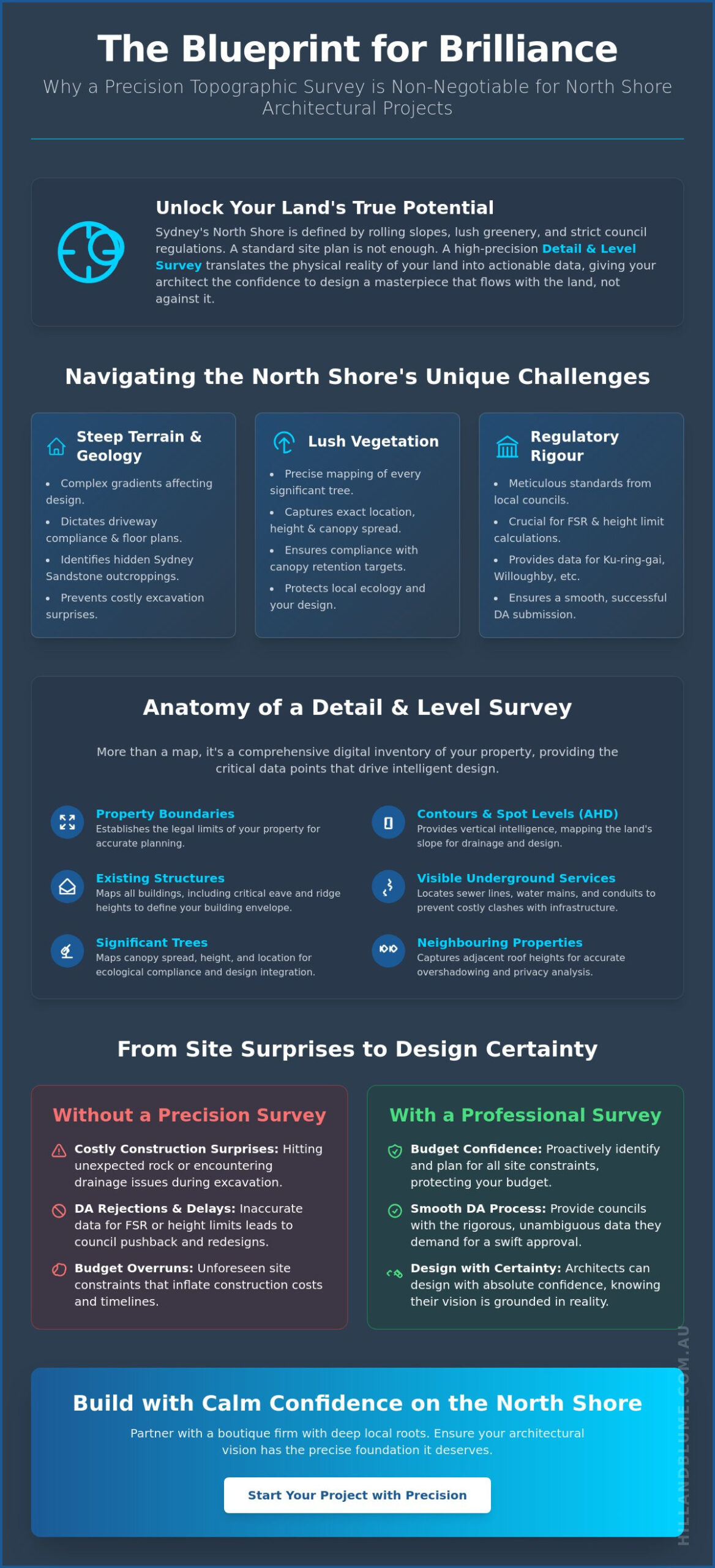
The North Shore isn’t just a location; it’s a specific way of life defined by heritage homes and lush, undulating landscapes. When you begin a project here, a topographic survey for architect North Shore requirements is your first point of clarity. Known professionally as a Detail and Level Survey, this document translates the physical reality of your land into a precise digital format. It captures every contour, every sandstone ledge, and every significant tree that defines your property’s potential. For your architect, this data is the difference between a design that flows with the land and one that fights it.
The region’s geography is famously complex. You are often dealing with steep gradients and the constant presence of Sydney Sandstone. These elements dictate where you can build, how you manage drainage, and the ultimate cost of your excavation. Without accurate AHD (Australian Height Datum) levels, you risk significant issues with flood modeling and sewer connectivity that could halt a project before it starts. A detailed topographic map provides the vertical intelligence needed to ensure your home sits safely and elegantly within its environment.
The Challenge of Steep Terrain and Vegetation
Elevation changes on the North Shore are rarely subtle. A site that looks manageable to the naked eye can reveal significant complexities once mapped. These gradients directly influence driveway compliance and the viability of split-level floor plans. Beyond the soil, the “leafy” reputation of our suburbs brings its own set of rules. We map the exact location, height, and canopy spread of every tree, ensuring your design respects the local ecology while meeting strict canopy retention targets. Identifying hidden rock outcroppings early also prevents the budget creep that occurs when builders hit unexpected sandstone during the first week of construction.
Regulatory Rigour: Ku-ring-gai, Willoughby, and North Sydney Councils
Councils like Ku-ring-gai, Willoughby, and North Sydney are known for their meticulous standards. They require topographic data that leaves no room for ambiguity. When calculating your Floor Space Ratio (FSR) or adhering to height-of-building limits on sloped land, even a few centimeters can be the difference between a swift approval and a costly redesign. Our professional surveying services ensure that every boundary and Significant Tree defined by local LEPs is accounted for, providing the rigorous data these authorities demand for a successful DA submission.
The Anatomy of a Detail and Level Survey: Data Points that Drive Design
A precision topographic survey for architect North Shore projects is much more than a simple map of boundaries; it’s a comprehensive digital inventory of your land’s unique character. While we’ve discussed the geographical challenges of our region, this specific survey type provides the raw data your architect needs to solve them. By identifying the exact location of existing structures, including eave heights and ridge lines, we provide the vertical constraints that define your building envelope. This level of mapping has long been an indispensable tool for government, science, industry, and it’s equally critical for your residential masterpiece.
Design excellence doesn’t happen in a vacuum. To protect your vision from council objections, we also capture the footprint and roof heights of neighboring properties. This data allows your architect to perform accurate overshadowing analysis and privacy assessments early in the design phase. We also locate visible evidence of underground utility services. Knowing where sewer lines, water mains, and electrical conduits sit ensures your site planning avoids costly clashes with essential infrastructure. It’s about creating a seamless path forward for everyone involved.
Contours, Spot Levels, and Site Features
Architects require high-resolution data to orchestrate a project successfully. We typically provide contour intervals of 0.25m or 0.5m, which reveal the subtle nuances of your land’s slope. While contours show the general flow, “spot levels” on hard surfaces like driveways and pool surrounds offer the surgical precision needed for drainage design. Every retaining wall, fence, and paved area is meticulously mapped to create a complete picture of the current site conditions. Our Detail and Level Surveys ensure no detail is left to chance.
Digital Deliverables: CAD, BIM, and 3D Modelling
The modern architectural studio operates in a three-dimensional world. We provide our data in DWG and PDF formats, ensuring they integrate perfectly into CAD and BIM workflows. By delivering data that is Revit-ready and correctly aligned to the MGA2020 map projection, we save your design team hours of manual translation. This digital synergy allows your architect to build a 3D topographic model that serves as a living foundation for your new home. If you’re ready to start this collaborative process, discussing your project requirements with a specialist surveyor is a wise first step.
Beyond the Basics: How Expert Surveying Prevents Costly Design Revisions
Designing in a vacuum, without precise site constraints, is a gamble few North Shore homeowners can afford. While we’ve discussed the importance of AHD levels for drainage, the integration of topographic mapping with boundary identification is equally vital. Your architect needs to know exactly where the legal limits of your property lie in relation to the physical terrain. Without this clarity, a beautiful new terrace could easily encroach upon a neighbor’s setback, leading to legal disputes that are far more costly than a professional survey. Our Detail and Level Surveys provide the absolute certainty required to build with confidence.
The Cost of Inaccuracy in North Shore Developments
In local council areas like Ku-ring-gai or Willoughby, the margin for error is non-existent. We’ve seen projects stalled by DA rejections simply because the submitted levels didn’t account for a neighbor’s existing eave height or a specific sandstone outcropping. These errors lead to months of delays and significant consultant fees to rectify. Precise data also allows your builder to provide a fixed-price tender for excavation. When the volume of rock to be removed is known exactly, you’re protected from the “rock clause” surprises that often haunt North Shore developments.
Value-Add Surveying: Identifying Opportunities, Not Just Constraints
A superior survey does more than point out obstacles; it reveals the hidden potential of your land. With accurate contour data, your architect can calculate the perfect floor levels to maximize sweeping valley views while maintaining the privacy your family deserves. This data also informs solar orientation, helping you capture the winter sun more effectively by understanding how the terrain and surrounding structures cast shadows throughout the year. To ensure your design rests on a solid legal foundation, we recommend reading our guide to Boundary Surveys, which explains how property integrity underpins every successful architectural journey.
The Collaborative Brief: Ensuring Your Surveyor and Architect Are in Sync
The success of a high-end development depends on the seamless orchestration of your professional team. While the technical accuracy of your data is paramount, the clarity of the initial conversation often dictates the project’s pace. Securing a precision topographic survey for architect north shore projects is most effective when it begins with a unified brief. You aren’t just hiring someone to measure land; you’re inviting a partner to provide the foundation for your future home. When everyone is aligned from the start, the design process moves from a series of hurdles to a clear path of creative expression.
It’s essential that your architect’s specific requirements are communicated to the surveyor before the field party arrives. This might include capturing specific ridge heights of a neighbor’s home to ensure your new second story doesn’t violate privacy setback rules. Sometimes, the survey area must extend beyond your physical fence line to account for shared drainage or significant street trees that could impact your footprint. Booking this service at the very start of the design phase ensures your architect isn’t working with assumptions that could lead to costly revisions later. Efficiency in the early stages creates the calm confidence needed for a successful project.
Essential Information for Your Surveyor
To provide the most accurate results, we require a few key pieces of information before we step onto the site. Providing your Title search details and any registered easements or covenants is the first step toward a comprehensive site plan. If your architect has identified particular trees that must be preserved or specific rock features they wish to incorporate into the landscape, these should be highlighted in the brief. You should also discuss whether a Full Boundary Definition is required alongside your Detail and Level Survey to ensure your new structures sit exactly where they are legally permitted.
Site Preparation for the Field Party
A little preparation on the ground goes a long way in ensuring the field team can capture data with surgical precision. Ensuring our team has access to all areas of your yard is vital; this includes unlocking side gates and ensuring pets are safely secured. If your property has heavy undergrowth or thick lantana, clearing these areas allows for more accurate ground level readings, which is critical for drainage calculations. If we need to capture levels on a neighbor’s property for overshadowing analysis, a quick courtesy call to them beforehand ensures a smooth and professional workflow for everyone involved. If you’re ready to align your project team for success, contact our specialist team to discuss your custom brief.
Hill & Blume: 90 Years of Surveying Excellence for North Shore Developments
Choosing the right partner for your project is about more than just finding a technician with a tripod. It’s about engaging a legacy of local expertise that has been part of the North Shore’s architectural evolution since 1932. At Hill & Blume, we’ve spent over 90 years refining our craft, moving from hand-drawn linen plans to the sophisticated digital models we provide today. When you commission a topographic survey for architect North Shore projects from our team, you’re securing a foundation built on decades of regional knowledge and a boutique approach that prioritizes your vision over high-volume turnover.
We believe that luxury residential development requires a specialized touch. Our Registered Surveyors don’t just measure land; they interpret the complex intersections of NSW property law and local topography to protect your investment. By choosing a firm deeply rooted in the local culture, you gain a partner who understands the nuances of North Shore land titles and the specific expectations of your design team. We provide the calm confidence that comes from knowing your site data is beyond reproach, allowing you and your architect to focus on the artistry of the build.
A Heritage of Precision and Trust
Our long history informs every measurement we take. We’ve mapped the changing face of our suburbs for generations, giving us an unparalleled understanding of the historical land titles and easements that define North Shore properties. This depth of experience ensures that our CAD-ready data is exactly what architects love to work with. It’s precise, clean, and ready for immediate integration into your design workflow. You can learn more about how we bridge the gap between technical data and architectural excellence by exploring our Contour and Detail Survey services.
Your Partner in North Shore Development
Local knowledge is the silent engine behind a smooth DA process. We understand the specific rigour required by councils across the region, ensuring that your topographic survey for architect North Shore submissions meets every regulatory standard without the need for costly revisions. We invite you to experience a more personal, professional level of service where your aspirations are met with tailored solutions. If you’re ready to secure the future of your property with a firm that values quality and traditional integrity, we’re here to help. Book your North Shore topographic survey today and let’s begin the journey toward your new home together.
Building Your Vision on a Solid Foundation
A masterpiece begins long before the first stone is laid. It starts with the absolute certainty of your site’s physical boundaries and contours. We’ve explored how high-precision data prevents the friction of council rejections and the hidden costs of excavation surprises. By choosing a partner who provides expert CAD and BIM-ready data, you empower your architect to design with total freedom and surgical accuracy. Starting your journey with a precise topographic survey for architect north shore projects ensures your vision remains uncompromised through every phase of development.
Our Registered Surveyors have specialized in the unique terrain and council requirements of this region since 1932. We bring nearly a century of heritage to your property, ensuring every detail is captured with the care it deserves. If you’re ready to unlock the full potential of your land and move forward with calm confidence, we invite you to connect with our boutique team. Request a Professional Survey Quote for Your North Shore Project today and take the first step toward architectural excellence. Your dream home deserves a foundation of integrity and expertise.
Frequently Asked Questions
What is the difference between a topographic survey and a boundary survey?
A topographic survey maps the physical landscape, including levels, existing structures, and natural features like trees or rock ledges. In contrast, a boundary survey confirms the legal perimeter and corners of your property. While they serve different technical purposes, we often combine them to provide your architect with a complete picture of both the physical terrain and the legal constraints of your site.
How much does a topographic survey cost for a North Shore property in 2026?
The investment for a topographic survey for architect North Shore projects is determined by the specific complexity of your land. Factors such as the steepness of the slope, the density of the “leafy” vegetation, and the ease of physical access all influence the final fee. We provide tailored, professional proposals that reflect the precise level of detail your architectural vision and local council require.
How long does it take to complete a detail and level survey on the North Shore?
Most residential surveys in our region are finalized within one to two weeks after our field party visits the site. This timeframe allows for the meticulous collection of data on the ground and the subsequent office processing required to create your digital plans. For properties with significant sandstone outcroppings or restricted access, we’ll provide a specific timeline during our initial consultation.
Why does my architect need the survey in a DWG format?
Architects require DWG files because they offer precise vector data that integrates seamlessly into CAD and BIM design software. This digital synergy allows your design team to build their 3D models on an absolute foundation, eliminating the risk of errors that occur with manual data entry. It’s the professional standard for ensuring that every line of your design respects the reality of the terrain.
Do I need a topographic survey for a simple granny flat or extension?
Yes, even smaller developments require accurate site data to secure a Development Application (DA) or Complying Development Certificate (CDC). Council authorities must see how your new structure manages drainage and adheres to setback limits relative to existing levels. Having this data early prevents the stress of a rejection caused by missing information or incorrect assumptions about your site’s topography.
Can a surveyor identify underground pipes and cables?
We identify utility services by locating visible surface indicators, such as manhole covers and inspection pits, and cross-referencing them with Dial Before You Dig records. While this provides a strong indication of where infrastructure lies, it’s essential for site planning to avoid clashing with sewer or water mains. This vertical intelligence ensures your new foundations are positioned safely and efficiently from the very beginning.
What happens if my survey doesn’t match my neighbour’s fence line?
It’s quite common for older fence lines on the North Shore to deviate from the actual legal boundary. If our survey identifies a discrepancy, we recommend a formal boundary definition to confirm the exact location of your property lines. This clarity is vital for preventing encroachment disputes and ensures that your new terrace or wall is built entirely within your own legal title.
Will a topographic survey help with my Ku-ring-gai Council DA approval?
Precision data is non-negotiable for a topographic survey for architect North Shore submissions to Ku-ring-gai Council. They maintain rigorous standards for height-of-building limits and Floor Space Ratio (FSR) calculations, especially on our region’s famous slopes. Providing them with a professional survey demonstrates a commitment to accuracy that often facilitates a smoother, more predictable path through the regulatory process.
Disclaimer
The information provided in articles published on this website is for general informational purposes only. While we make every effort to ensure the accuracy, completeness, and timeliness of the content, the material is based on our understanding of the industry at the time of writing and may not reflect the most current developments, regulations, or standards. All opinions expressed in our articles are those of the respective authors and do not necessarily represent the official position of the website or its affiliates. The content should not be considered professional, legal or technical advice, and should not be relied upon as a substitute for consultation with qualified professionals