
What if the most expensive mistake in your home renovation isn’t the marble countertop or the custom cabinetry, but a single misplaced line on a drawing? In the 2026 planning landscape, securing a precise survey report for council approval nsw is no longer just a box to tick; it’s the legal foundation of your entire project. You’ve likely felt the weight of the NSW planning system, where acronyms like DA, CDC, and BASIX can feel like a barrier to your vision. It’s natural to worry that a hidden boundary dispute or an overlooked regulation might stall your progress or lead to unexpected costs down the line.
At Hill & Blume, we believe your journey toward a new home should be defined by excitement, not anxiety. This guide provides the clarity you need to move forward with confidence. We offer a transparent look at the essential surveys required to protect your investment and satisfy local authorities. We’ll explore the impact of the 2024 regulations, explain exactly what your architect needs to see, and show you how to ensure your property boundaries remain legally secure for decades to come. By the end of this guide, you’ll have a clear roadmap to a compliant, stress-free approval process.
Key Takeaways
- Understand why a precise survey report for council approval nsw acts as the essential legal foundation for your development application or complying development certificate.
- Explore the nuances of a Detail and Level Survey, the gold standard required by architects to translate your land’s unique topography into a viable design.
- Clarify the distinction between an Identification Survey for boundary security and a Detail Survey for construction to avoid costly administrative delays.
- Prepare your property with our expert checklist, ensuring every adjacent feature is captured to meet the specific requirements of your local Sydney council.
- Learn why engaging a Registered Surveyor is the only way to legally secure your boundaries and protect your home’s long-term value.
Navigating the NSW Planning System: Why Council Requires a Survey Report
Every home transformation begins not with a shovel, but with a precise set of data. In the eyes of local government, your property isn’t just a lifestyle haven; it’s a defined parcel of land within a complex regulatory web. A professional survey report for council approval nsw serves as the definitive legal foundation for your project. It translates the physical reality of your site into the digital language required by the NSW Planning Portal. Without this verified data, your vision remains a sketch rather than a buildable plan.
Council planners use this report to assess critical compliance factors. They can’t approve building heights, verify side setbacks, or calculate potential overshadowing of a neighbor’s garden without a surveyor’s field data. It’s about precision. If your plans show a two-meter setback, but the boundary is actually ten centimeters closer than you thought, the entire design could be illegal. By adhering to the rigorous standards established for Surveying in Australia, a registered surveyor ensures your architect builds on fact, not assumptions.
DA vs. CDC: How the Survey Requirements Change
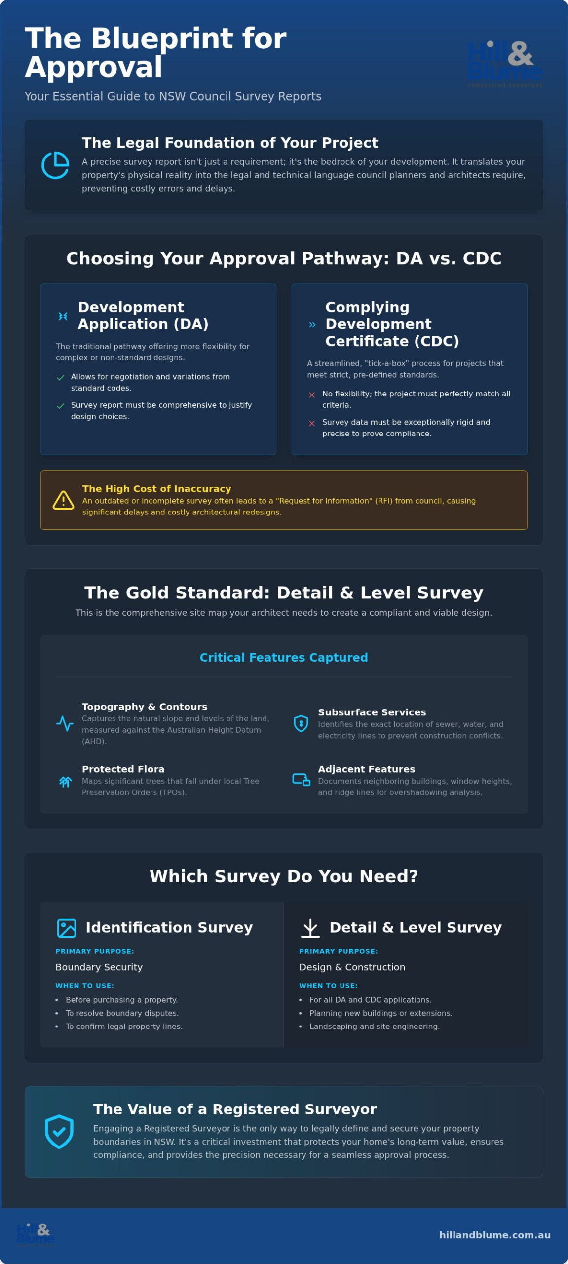
Choosing your approval pathway significantly impacts the level of detail your surveyor must provide. A Development Application (DA) offers some flexibility, but a Complying Development Certificate (CDC) is a “tick-a-box” process. Because a CDC bypasses full Council review, the survey data must be exceptionally rigid. Your certifier needs to see exactly where “Exempt Development” boundaries lie to ensure your project qualifies. A tailored surveying service provides the specific metadata required to satisfy these strict standards without a hitch.
The Consequences of an Inaccurate or Outdated Survey
The most common delay in the NSW planning system is the dreaded “Request for Information” (RFI). This often happens when a survey is outdated or lacks the “adjacent features” Council requires. If your site data is incorrect, you face the high cost of redesigning architectural plans halfway through the process. It’s a domino effect that drains your budget and your patience. As of 2026, all Council submissions require digital-first survey data that aligns perfectly with the Land Registry Services’ Online Form Builder to ensure a seamless approval.
The Detail and Level Survey: The Gold Standard for Council Approval
A sophisticated design relies on more than just aesthetic vision; it requires a deep understanding of the land’s physical character. While a basic boundary check confirms where your property ends, a survey report for council approval nsw provides the granular data that transforms a concept into a compliant reality. This comprehensive mapping, often called a Detail and Level Survey, captures every subtle contour and man-made feature of your site. It’s the first document your architect will request, and for good reason.
Without a precise contour and detail survey, your design team is essentially working in the dark. They need to understand the “Level” component, which is measured against the Australian Height Datum (AHD). This standardized vertical scale allows Council to assess how your home sits in relation to the street and neighboring properties. It’s how they determine if your roofline respects height limits or if your new deck will overlook a neighbor’s private courtyard. Understanding your project’s place within the broader NSW planning approval pathways is essential for a smooth submission.
Critical Features Captured in a Detail Survey
We don’t just look at what’s on your land; we look at what surrounds it. A truly professional survey captures the intricate details that Council planners scrutinize most closely. This includes:
- Subsurface Services: Identifying the exact location of sewer, water, and electricity lines to prevent costly construction conflicts or infrastructure damage.
- Protected Flora: Mapping significant trees that fall under local Tree Preservation Orders (TPOs), ensuring your design works with nature rather than against it.
- Adjacent Context: Documenting the floor levels and window placements of neighboring buildings. This data is vital for bulk and scale analysis and ensures your privacy is protected.
Why a “Digital Twin” of Your Land Matters
In 2026, the standard for surveying has evolved into a digital-first experience. By creating a high-resolution “digital twin” of your property, we provide data that integrates seamlessly with modern architectural BIM models. This 3D precision is particularly vital for Sydney’s iconic steep topography, where even a few centimeters of variance can impact drainage or structural stability. Our comprehensive services ensure that every pre-construction detail is accounted for with boutique care. If you’re ready to lay the right foundation for your project, we invite you to speak with our specialist team today.
Identification Surveys vs. Detail Surveys: Which One for Which Approval?
Understanding the distinction between survey types is the first step toward a seamless project. Many homeowners assume a survey is a singular document, but in the NSW property market, different reports serve vastly different masters. While you might have received an Identification Survey when you purchased your home, that document alone is rarely a sufficient survey report for council approval nsw. It’s a snapshot of legal status, not a blueprint for future creation.
An Identification Survey focuses on the legal relationship between your structures and your land boundaries. It identifies encroachments, easements, and covenants that might restrict your plans. It’s the document solicitors and banks demand to ensure the house you’re buying is legally situated on its lot. However, it lacks the topographic levels and site features an architect needs to design your renovation. Conversely, a Detail Survey provides that design canvas but doesn’t always re-establish legal boundaries unless specifically requested. For property owners, understanding the legal weight of a boundary survey is your best defense against future neighbor disputes.
The Identification Survey Report Explained
This report acts as a legal verification of your property’s integrity. It confirms that fences align with title dimensions and that no part of your neighbor’s garage is resting on your land. It also highlights critical restrictions like drainage easements or heritage covenants. These details are vital; Council won’t approve a structure that interferes with existing legal rights of way. Consulting BOSSI surveyor publications can provide further insight into why these official records are non-negotiable for property transactions and legal certainty.
The Hybrid Approach for Renovations and Extensions
For a sophisticated renovation or extension, Hill & Blume recommends a hybrid approach. We combine boundary identification with comprehensive detail mapping. This ensures your new architectural masterpiece is not only beautifully designed but also perfectly positioned within your legal limits. There’s no greater stress than discovering an extension has crossed a boundary line mid-build. By engaging an expert who understands what is a registered surveyor in NSW, you’re investing in a curated experience that prioritizes precision. For complex subdivision or strata projects, providing both sets of data is often the only way to secure final sign-off.
Avoiding Delays: A Checklist for a Council-Ready Survey Report
The transition from a conceptual dream to a formal submission is often the most delicate phase of your property journey. While the technical data is our responsibility, your preparation ensures the field work is as efficient and unobtrusive as possible. A high-quality survey report for council approval nsw isn’t just about what is found on your land, but how clearly that information is presented to the planners who hold the keys to your project’s future. By taking a few deliberate steps before we arrive, you can prevent the administrative friction that often leads to “Requests for Information” and lengthy delays.
Preparing Your Site for the Surveyor
To capture the precision your architect requires, our laser equipment needs a clear line of sight across your property. We recommend clearing heavy vegetation or debris that might obstruct access to your boundaries or significant site features. Our team will need to reach every corner of the lot, including sensitive areas near neighbor fences. If your project requires “offset” levels from an adjoining property to calculate overshadowing or privacy impacts, a quick, friendly word with your neighbors beforehand can smooth the way. This collaborative approach ensures we respect the local community fabric while gathering the essential data for your file.
Technical Requirements for Council Submission
Council planners look for specific markers of quality and recency before they begin their assessment. Most Sydney councils require a survey that is no more than 12 to 24 months old, as site conditions and local infrastructure can change. Your report must feature a clear North point, a professional scale, and a detailed legend that explains every symbol used on the plan. Most importantly, the document must bear the official seal of a Registered Surveyor. This seal is your guarantee of legal accuracy and a non-negotiable requirement for any government submission.
In 2026, compatibility with the NSW Planning Portal is paramount. We ensure your data is formatted for immediate digital upload, aligning perfectly with the Land Registry Services’ digital standards. Once your survey report for council approval nsw is successfully processed, the next logical step in your journey is a professional construction set-out to ensure your builder follows the approved plans with absolute fidelity. If you are ready to prepare your site for a seamless approval, we invite you to reach out to our specialist team for a tailored consultation.
The Value of a Registered Surveyor: Ensuring Precision in NSW
In the complex ecosystem of Sydney property development, the title “surveyor” is often used loosely. However, under the Surveying and Spatial Information Act 2002, the term “Registered Surveyor” carries a specific legal weight that is non-negotiable for your project. In New South Wales, only a Registered Surveyor has the legal authority to define or re-establish land boundaries. When you submit a survey report for council approval nsw, you aren’t just providing a map; you’re providing a sworn legal document. This certification is what gives Council the confidence to approve your plans, knowing that the physical reality matches the legal title.
At Hill & Blume, our legacy is built on this foundation of trust. Founded in 1932, we’ve spent over 90 years meticulously documenting the changing face of Sydney. This deep archive of historical data provides an unmatched advantage, allowing us to resolve complex boundary discrepancies that newer firms might overlook. We view every survey report for council approval nsw as a form of insurance for your most valuable asset. It’s a boutique, detail-oriented approach that ensures your home’s footprint is secure, protecting you from the heartache of future litigation or construction errors.
Professional Integrity and Expert Witness
The role of a surveyor extends far beyond the field. Should a boundary dispute ever reach the Land and Environment Court, a Registered Surveyor acts as an expert witness, providing the definitive evidence required to resolve the matter. Council planners trust reports from established, registered firms because they know the data is backed by professional indemnity and rigorous standards. We utilize the most sophisticated technology available, from high-precision GPS and total stations to detailed 3D scanning. This tech allows us to capture the “digital twin” of your land with a level of accuracy that uncertified site plans simply cannot match.
Choosing Your Survey Partner in Sydney
Selecting the right partner for your project requires looking beyond the bottom line of a quote. A transparent survey quote should clearly outline inclusions, such as the location of neighboring windows or the identification of easements. We prioritize a partnership-oriented narrative, ensuring you feel supported through every regulatory hurdle. We invite you to use our Buying Guide to vet your next surveyor and ensure they meet the high standards your property deserves. By choosing a firm that values quality over volume, you’re investing in a curated experience that brings calm confidence to the entire development process.
Building Your Future on a Foundation of Certainty
Your property journey in New South Wales is an evolution of vision, and securing a precise survey report for council approval nsw is the moment that vision becomes a tangible reality. By understanding the critical distinction between detail mapping and boundary identification, you’ve already taken the most important step toward avoiding costly redesigns and administrative delays. You now possess the clarity to navigate the 2026 planning landscape with confidence, ensuring your architect has the exact data required to create a home that is as compliant as it is beautiful.
At Hill & Blume, we bring over 90 years of Sydney surveying expertise to every project. Our team of Registered Surveyors specializes in providing boutique, detail-oriented data that ensures 100% Council compliance, tailored specifically to the needs of homeowners and their design teams. We invite you to request a tailored survey quote for your NSW Council approval and experience a partnership that values quality and local integrity above all else. Your dream home deserves a start that’s as secure as it is inspired.
Frequently Asked Questions
Does every Development Application in NSW require a survey report?
Most Development Applications in New South Wales require a professional survey report to proceed. Council planners cannot accurately assess your project’s impact on building height, side setbacks, or neighboring privacy without a verified set of site data. This report serves as the legal foundation for your submission. While minor internal renovations might occasionally bypass this step, any project altering the building footprint or height will necessitate a current survey.
Can I use a survey report from a previous owner for my Council approval?
You can only use a previous survey if it’s recent and comprehensive. Most Sydney councils require a survey report for council approval nsw to be dated within the last 12 to 24 months. Site conditions, such as new neighbor extensions or infrastructure changes, can render older reports inaccurate. Additionally, a pre-purchase survey often lacks the topographic levels and adjacent window placements that an architect needs for a successful submission.
What is the difference between a land surveyor and a registered surveyor in NSW?
The distinction lies in legal authority and professional certification. While a land surveyor is a broad term for anyone in the field, a Registered Surveyor is formally recognized under the Surveying and Spatial Information Act 2002. In New South Wales, only a Registered Surveyor has the legal power to define property boundaries or sign off on official plans for Council. This registration provides you with legal certainty and ensures your boundaries are professionally protected.
How much does a survey report for Council approval typically cost in Sydney?
Surveying costs in Sydney vary based on the complexity of your site’s topography and the specific requirements of your local council. Factors such as heavy vegetation, steep slopes, or the need to capture detailed neighbor data will influence the final investment. We recommend obtaining a tailored quote that reflects your property’s unique characteristics. This ensures you receive a boutique service that covers all necessary inclusions without hidden administrative fees later in the process.
How long does it take for a surveyor to complete a report for Council?
Most final survey reports are completed within 3 to 5 business days after the initial site visit is conducted. This timeframe allows our team to process the field data, verify boundary positions against historical records, and draft the detailed plans required for your submission. Complex sites or large subdivisions may require additional time for meticulous data verification. We prioritize a steady and deliberate pace to ensure the precision your architect and Council expect.
What happens if my survey report shows a boundary encroachment?
If an encroachment is discovered, your Registered Surveyor will clearly document the location and extent of the issue on the plan. This transparency is vital for your legal protection. You may need to seek legal advice or enter into a boundary agreement with your neighbor to resolve the matter before Council grants approval. Addressing these discrepancies early prevents expensive construction errors and ensures your property’s long-term value remains secure and undisputed.
Do I need a survey report for a Complying Development Certificate (CDC)?
Yes, a survey report for council approval nsw is a mandatory requirement for the CDC pathway. Because Complying Development bypasses the full merit assessment of a traditional DA, your private certifier relies heavily on the surveyor’s data to verify that your project meets every strict development standard. This includes precise calculations for site coverage, landscaped areas, and setbacks. A highly detailed report ensures your certificate is issued without administrative friction or delays.
Will the surveyor need to come inside my house to complete the report?
Surveyors typically complete their work by accessing the exterior of your property to capture land contours, boundaries, and existing structures. You don’t need to provide internal access unless your specific project involves a sophisticated internal renovation that requires precise floor levels or wall thicknesses. We always coordinate with you to ensure our visit is seamless and respects your privacy, focusing our expertise on the site’s external landscape and legal positioning.
Disclaimer
The information provided in articles published on this website is for general informational purposes only. While we make every effort to ensure the accuracy, completeness, and timeliness of the content, the material is based on our understanding of the industry at the time of writing and may not reflect the most current developments, regulations, or standards. All opinions expressed in our articles are those of the respective authors and do not necessarily represent the official position of the website or its affiliates. The content should not be considered professional, legal or technical advice, and should not be relied upon as a substitute for consultation with qualified professionals