

What if the success of your architectural vision hinges not on the design itself, but on a single measurement hidden within your property’s terrain? You’ve likely felt that familiar weight of uncertainty as you prepare your development application, wondering if a terminology mix-up or a slight boundary discrepancy will trigger a frustrating Council rejection. Securing a professional detail survey for DA submission sydney is the most vital step you can take to ensure your project moves from a conceptual sketch to a reality accepted by the City of Sydney without costly Request for Information delays.
We believe that every exceptional Sydney home begins with an intimate understanding of the land it sits upon. This 2026 guide demystifies the new mandatory LandXML digital lodgement requirements and clarifies the essential differences between topographic, detail, and contour plans. You’ll discover how a precise survey acts as a spatial insurance policy, providing the peace of mind you need to hand your architect a perfect CAD file. By grounding your project in accurate data, you ensure your property boundaries are respected and your approval path remains clear.
Key Takeaways
- Learn why a professional detail and level survey is the non-negotiable first step in the Sydney DA process, ensuring your architect works with absolute precision.
- Discover the specific site features, including vegetation and terrain, that must be captured in a detail survey for DA submission sydney to meet strict council standards.
- Understand why only a Registered Land Surveyor can provide the legal boundary certainty required to prevent encroachment disputes and costly design revisions.
- Find out how to streamline your site visit and project timeline by properly preparing your property for the surveying team’s arrival.
- Explore how nine decades of local expertise and a boutique, detail-oriented approach can elevate your project from a simple plan to a successful approval.
Navigating the Sydney DA Process: Why a Detail Survey is Your First Step
The journey of transforming a Sydney property begins long before the first brick is laid. It starts with an intimate, mathematical understanding of the earth beneath your feet. A detail survey for DA submission sydney isn’t just a technical requirement; it’s the digital canvas upon which your architect paints your future home. Without this precise foundation, even the most inspired designs risk being grounded in fiction rather than reality. You deserve a process that flows with grace, and that flow begins with data that Council can trust implicitly.
Sydney councils, from the historic streets of the Inner West to the coastal slopes of the Northern Beaches, demand a level of precision that only a professional survey can provide. They use this data to assess how your proposal interacts with the surrounding environment. By providing a high-fidelity map of your site, you effectively insulate your project against the dreaded “Request for Information” (RFI) from Council. An RFI is more than a letter; it’s a project pause button that can cost months of momentum. Accurate data ensures that when a planning officer reviews your application within the broader framework of Urban planning in Australia, they see a proposal that is technically sound and ready for approval.
For your architect, the survey is a tool for risk mitigation. It allows them to design with confidence, knowing that every boundary, window, and ridge line is exactly where it appears on their screen. This precision prevents the heartbreak of discovering design errors during the construction phase. Whether you are looking for boundary clarity or a comprehensive site analysis, exploring our specialized surveying services is the first step toward a seamless development experience.
The Difference Between a DA and a CDC Survey
While both pathways require professional site data, a Development Application (DA) often demands a more nuanced detail survey for DA submission sydney than a Complying Development Certificate (CDC). DAs are typically required for more complex projects, such as those involving heritage conservation areas or significant environmental constraints. Your survey must capture every subtle detail, from the exact canopy spread of a protected tree to the intricate levels of a neighboring property’s windows, to satisfy the bespoke requirements of your local Council’s planning controls.
Topographic, Contour, or Detail? Clearing the Terminology
In Sydney real estate circles, you’ll often hear these terms used interchangeably, yet they serve a singular, sophisticated purpose. A topographic survey captures the natural features, a contour survey maps the slopes, and a detail survey brings it all together with man-made structures. The “Level” component is perhaps the most critical; it provides height data relative to the Australian Height Datum (AHD). This allows your design team to perform accurate overshadowing analysis, ensuring your new build respects the sunlight and privacy of your neighbors while maximizing your own lifestyle experience.
Anatomy of a DA-Ready Detail and Level Survey
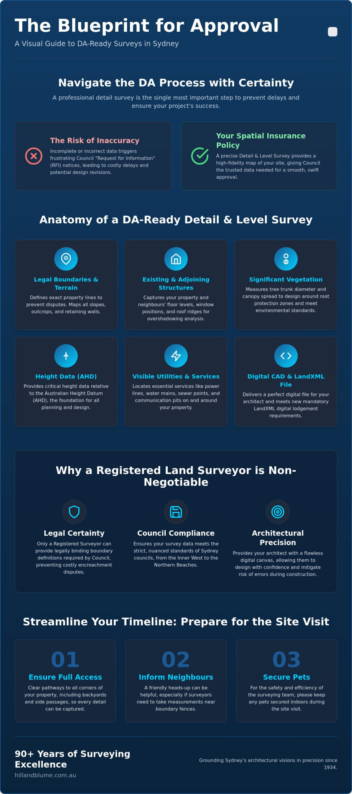
Think of your survey as a high-definition portrait of your land. It captures the rugged beauty of Sydney sandstone outcrops alongside the precise lines of your existing retaining walls. This document is the primary tool for your design team, ensuring that every natural and man-made nuance is accounted for before the first sketch is drawn. A detail survey for DA submission sydney translates the physical reality of your block into a precise digital format that Council planners can interpret with ease.
Trees are often the heart of a Sydney garden, but they’re also a critical planning factor in any development application. We don’t just mark a tree’s location; we measure the trunk diameter and canopy spread with absolute care. This level of detail allows your architect to design around root protection zones, ensuring your project meets local environmental standards without the frustration of unexpected design revisions. When you provide Council with accurate vegetation data, you demonstrate a commitment to the local landscape that speeds the approval process.
Existing structures on and around your site tell a story of the neighborhood. We record neighboring floor levels, roof ridges, and window positions to ensure your new build respects the sunlight and privacy of those around you. This isn’t just about data; it’s about harmony. Utility services, the silent pulse of your property, are also meticulously mapped. We locate visible sewer, water, and electrical connections to ensure your new build integrates seamlessly with existing infrastructure. This foresight prevents the stress of mid-construction redesigns when a hidden pipe is suddenly unearthed.
The Importance of Australian Height Datum (AHD)
In the world of surveying, AHD is our universal north star. It’s a vertical datum used to represent height above mean sea level across the continent. Without it, your drainage plans could fail or your driveway might be too steep for Council’s strict gradients. We ensure every level is tied to this standard, allowing your engineers to design with absolute vertical certainty. It’s the only way to ensure your project respects the unique topography of the Sydney basin.
Legal Layers: Easements, Covenants, and Restrictions
Some of the most significant constraints on your property are invisible to the naked eye. Easements for underground pipes or restrictions on building height can halt a DA in its tracks if they aren’t identified early. Our team at Hill & Blume meticulously uncovers these legal layers, identifying restrictions on the use of land that could impact your design. If you’re ready to uncover the full potential of your site, you might speak with our registered surveyors to discuss your specific property constraints and ensure a smooth path toward your dream home.
Boundary Integrity: Why a Registered Surveyor is Non-Negotiable
In the delicate dance of Sydney property development, boundaries are the invisible lines that define your rights and your responsibilities. While many technicians can operate a laser or a drone, only a Registered Land Surveyor holds the legal authority in New South Wales to define where your land truly ends and your neighbor’s begins. This distinction is the cornerstone of a successful detail survey for DA submission sydney. It’s the difference between a drawing that looks professional and a document that carries the full weight of the law.
When you engage a boutique firm like Hill & Blume, you aren’t just buying a plan; you’re securing a legacy of cadastral integrity. Since 1932, we’ve understood that a boundary error isn’t just a minor inconvenience. It’s a risk to your entire investment. Building even a few centimeters over a boundary line can lead to mandatory demolition orders or protracted legal battles. A high-quality detail survey for DA submission sydney prevents these catastrophic design errors by grounding your project in undeniable spatial truth. You deserve the certainty that only a signature from a Registered Land Surveyor can provide.
Our commitment to precision mirrors the high-end lifestyle you are seeking to create. We treat every project with a refined aesthetic and a discerning eye for detail, ensuring that your property’s boundaries are not just measured, but protected. This level of care is what distinguishes a boutique agency from a clinical corporate firm. It is a quiet confidence that your project sits exactly where it should, anchored by traditional integrity and modern expertise.
Encroachments and Disputes: A Proactive Approach
Existing encroachments are more common in Sydney’s established suburbs than you might imagine. A neighbor’s guttering, a misplaced retaining wall, or a fence that has drifted over decades can all complicate your development application. A precise detail survey identifies these issues before they become disputes. It allows you to approach your neighbors with facts rather than assumptions, fostering a collaborative spirit from the outset. This proactive clarity is what provides the lasting peace of mind that your project is legally sound and your relationships remain intact.
NSW Surveying Standards and the 2002 Act
The Surveying and Spatial Information Act 2002 sets the rigorous standards that govern our profession. These regulations ensure that every measurement we take is part of a legally defensible record. Following these professional standards isn’t just about compliance; it’s about craftsmanship. Your survey becomes a permanent part of the state’s land registry system, a testament to the quality of your project. For those seeking absolute certainty in boundary identification, we invite you to explore our comprehensive Hill & Blume Services to see how we can protect your property’s future.
Preparing for Your Site Visit: How to Streamline Your DA Timeline
The transition from conceptualizing your project to gathering hard data is a pivotal moment in your development journey. It’s a phase that requires a graceful coordination between you, your architect, and your surveying team. By approaching the site visit with a spirit of preparation, you ensure that your detail survey for DA submission sydney is completed with the effortless precision that characterizes high-end property development. This collaboration is the first step in transforming your vision into a reality that Council will appreciate.
Before our team arrives, a brief consultation helps us define the exact scope of work. We work closely with your design team to understand the unique nuances of your site. On the day of the field work, ensuring clear site access is perhaps the most practical way you can help. Clearing dense vegetation from boundary lines and securing your pets allows our surveyors to move through the property with focus and care. This preparation isn’t just about speed; it’s about creating an environment where every measurement can be taken with absolute certainty.
Once the field work is complete, the process moves into our boutique studio. We transform raw spatial data into sophisticated CAD files, a process that involves rigorous quality assurance. Every line and level is checked against our high standards before being finalized. This seamless move from the physical earth to a digital plan is where our 90 years of expertise truly shines, providing your architect with a flawlessly accurate foundation for their design work.
Information Your Surveyor Needs From You
To provide a truly customized service, we invite you to share any existing house plans or previous surveys you might have in your possession. If there are specific elements that require extra attention, such as a cherished heritage tree or a complex shared wall, identifying these early ensures they are captured with the necessary detail. We also speak the language of your architect, so please provide any specific CAD layer requirements they may have requested to ensure the files integrate perfectly into their software.
Timeline Expectations for Sydney DAs
In the fast-paced Sydney property market, timing is everything. While typical turnaround times for a final plan delivery can vary based on site complexity, booking your survey early is the most effective way to prevent project bottlenecks. With the 2026 shift toward mandatory digital plan lodgement, the final quality assurance check by a Registered Surveyor is more critical than ever. This deliberate, considered pace ensures that your submission is right the first time. If you are ready to begin this refined process, you can book your site visit today to secure your place in our schedule.
Partnering with Hill & Blume: 90 Years of Surveying Excellence
Since 1932, Hill & Blume has been a silent partner in the creation of Sydney’s most refined residential and commercial spaces. Our story is one of enduring precision. We’ve spent over nine decades mapping the unique terrain of the Sydney basin, Newcastle, and the Central Coast. This longevity isn’t just a number; it’s a testament to the trust we’ve built with generations of homeowners and the city’s leading architects. When you commission a detail survey for DA submission sydney from us, you’re engaging with a legacy of expertise that understands the local landscape like no other.
We pride ourselves on the boutique advantage. Unlike larger, clinical corporate agencies that prioritize high-volume turnover, we focus on the depth of our relationships. You’ll enjoy direct access to senior expertise and a personalized service that feels more like a curated experience than a standard transaction. We combine the latest high-end equipment with a human touch, ensuring that modern technology never replaces traditional integrity. It’s this balance of craftsmanship and care that makes us the preferred choice for architects who require absolute certainty for their most complex projects.
Our work is a hand-crafted seal of quality. We don’t just provide data; we provide a polished foundation for your lifestyle aspirations. If you are also researching premium climate control systems for your property, you can learn more about energy-efficient options from Melbourne Hydronic Heating as you consider the best infrastructure for your build. By choosing a specialized local authority, you ensure your project is anchored in the local fabric with a sense of calm confidence.
Beyond the DA: Ongoing Support for Your Build
Our commitment to your success doesn’t end once your application is lodged. We remain your partners through every stage of the journey, from the initial sketch to the final occupation certificate. Whether you require a construction set-out to ensure your build matches the approved plans or a work-as-executed (WAE) survey for final Council sign-off, our team is ready to assist. For a deeper understanding of how these early stages influence your entire project, we invite you to read our Contour and Detail Survey Guide.
Request Your Custom Survey Proposal
We believe in transparency and the value of a “right first time” approach. Hill & Blume provides clear, fixed-fee proposals that reflect the specific requirements of your site, ensuring there are no hidden surprises as your project progresses. Investing in a premium detail survey for DA submission sydney today is the most effective way to protect your property investment for the future. It’s time to move forward with the peace of mind that only ninety years of experience can provide. We invite you to contact Hill & Blume to start your DA journey and experience a more refined way to build.
Begin Your Project with Absolute Spatial Certainty
Your vision for a refined Sydney home deserves a foundation built on truth. By prioritizing a detail survey for DA submission sydney, you aren’t just meeting a Council requirement; you’re protecting your design from the heartbreak of boundary disputes and the frustration of design revisions. We’ve explored how identifying invisible easements and establishing precise AHD levels creates a seamless path toward approval.
With over 90 years of Sydney surveying expertise, Hill & Blume brings a rhythmic, polished approach to every site. Our Registered Land Surveyors are trusted by the city’s leading architects and developers to deliver the precision that modern DAs demand. We believe that a boutique partnership, anchored in traditional integrity and local knowledge, is the most effective way to ensure your project’s success. It’s time to transform your aspirations into a technically sound reality.
Secure your Sydney DA with a precise Hill & Blume Detail Survey
We look forward to helping you navigate the complexities of the Sydney landscape with confidence.
Frequently Asked Questions
Do I really need a detail survey for a small renovation in Sydney?
Yes, most Sydney councils require a professional survey if your renovation changes the building footprint or external heights. Even minor additions can impact overshadowing or site coverage ratios. A detail survey for DA submission sydney provides the essential baseline data that planning officers need to assess your proposal’s impact on the surrounding neighborhood.
How much does a detail survey for a DA submission typically cost?
The investment for a survey depends entirely on the complexity of your terrain and the size of your property. Factors such as dense vegetation, steep slopes, or heritage constraints influence the time our team spends on-site. We provide tailored, fixed-fee proposals that reflect the specific nuances of your land and the high level of precision required for a successful application.
How long is a detail survey valid for a Sydney Council application?
A survey remains valid as long as no physical changes have occurred on your site or the immediate neighboring properties. However, most architects and councils prefer data that’s less than two years old. This ensures your submission meets the 2026 digital lodgement standards and accounts for any recent developments that might affect your project’s approval.
Can my architect do the site measurements instead of a surveyor?
While architects are masters of design, they’re not legally authorized to define property boundaries or establish heights relative to the Australian Height Datum. Only a Registered Land Surveyor can provide a plan that Council accepts as a legally defensible document. This professional certification ensures your architect’s vision is built on a foundation of absolute spatial truth.
What happens if my survey reveals an encroachment on my boundary?
Discovering an encroachment is an opportunity to resolve potential disputes before they become costly legal issues. Your survey acts as a factual, mathematical record of the site’s physical reality. This clarity allows you to have a considered conversation with your neighbor or adjust your design before lodgement, ensuring your detail survey for DA submission sydney is beyond reproach.
Does a detail survey include underground service locations like pipes?
A standard detail survey identifies visible surface indicators such as manholes, water meters, and electrical pits. While we map these essential connections, specialized utility locating is sometimes required for a complete view of deep underground infrastructure. We can coordinate these additional layers to ensure your new design avoids any hidden pipes or cables.
Why do I need a Registered Surveyor if I already have old property plans?
Old plans often lack the digital precision required by today’s sophisticated planning portals and don’t account for decades of site movement or fence drift. A Registered Surveyor provides a fresh, certified measurement that carries full legal weight in New South Wales. It’s the only way to guarantee your project complies with the current Surveying and Spatial Information Regulation 2024.
Can Hill & Blume provide CAD files directly to my architect?
Yes, we deliver high-quality CAD files that integrate perfectly with your architect’s specific design software. We prioritize a seamless digital workflow to save your project time and reduce the risk of manual data entry errors. By providing accurate, layered files, we ensure your design team can begin their creative work with total confidence in the site data.
Disclaimer
The information provided in articles published on this website is for general informational purposes only. While we make every effort to ensure the accuracy, completeness, and timeliness of the content, the material is based on our understanding of the industry at the time of writing and may not reflect the most current developments, regulations, or standards. All opinions expressed in our articles are those of the respective authors and do not necessarily represent the official position of the website or its affiliates. The content should not be considered professional, legal or technical advice, and should not be relied upon as a substitute for consultation with qualified professionals