

Could a few centimetres of missed elevation be the silent architect of a future boundary dispute? When you’re planning a bespoke development in Sydney, the ground beneath your feet is more than just soil; it’s the legal and topographical blueprint for everything you intend to build. It’s natural to feel a sense of unease regarding the detail and level survey cost sydney, especially when quotes seem to fluctuate as much as the Harbour tides. You deserve a partnership that prioritizes clarity over confusion and precision over guesswork.
We understand that the pre-construction phase can feel fraught with unexpected expenses and complex technical jargon. This guide is designed to offer you a clear, sophisticated perspective on how to secure a precise foundation for your project. You’ll discover the specific factors that influence pricing in 2026, from the intricacies of the SSIR 2024 regulations to the mandatory LandXML digital lodgments. We will walk through exactly what determines your investment, ensuring your architectural plans are built on a bedrock of accurate, council-compliant data that respects both your vision and your budget.
Key Takeaways
- Gain a clear understanding of how a detail and level survey acts as the essential canvas for your architect, capturing every topographical nuance of your land.
- Discover the specific factors that influence the detail and level survey cost sydney in 2026, helping you navigate the pricing landscape for both standard and complex residential projects.
- Learn why prioritizing accuracy over the lowest quote protects your project from the hidden expenses of inaccurate levels and missing site features.
- Identify the practical steps you can take to prepare your site, ensuring your surveyor can deliver the most efficient and precise data for your development.
Defining the Detail and Level Survey: More Than Just a Map
Imagine your property as a blank canvas. In a city as geographically diverse as Sydney, that canvas is rarely flat or predictable. A detail and level survey, often referred to as a topographic survey, is the process of capturing every nuanced feature of your land. It’s much more than a simple drawing; it is the definitive legal and topographical foundation upon which every successful building design is constructed. For homeowners looking to transform a vision into a physical structure, this document becomes the primary language spoken between your surveyor, architect, and structural engineer.
In our local landscape, this specific survey is considered the gold standard for residential developments. Whether you are planning a sophisticated renovation in the Eastern Suburbs or a modern rebuild in the Inner West, the data gathered here dictates what is possible. While you may be initially focused on the detail and level survey cost sydney, it’s helpful to view this as an investment in the integrity of your entire project. Understanding what is a land survey helps illustrate why this level of precision is non-negotiable for a seamless transition from paper to pavement.
The Role of Topography in Architectural Precision
Architects don’t just design houses; they design for specific environments. Accurate contour lines are the heartbeat of a great design. They prevent the heartbreak of expensive design revisions mid-construction, which often occur when “near enough” data is used. In Sydney’s complex catchments, site levels are inextricably linked to drainage planning and overland flow requirements. If your survey isn’t precise, your entire water management system could be flawed. High-end property builds require a level of craftsmanship that begins with the very first measurement taken on-site.
Detail Surveys vs. Boundary Identifications
Confusion often arises between a detail survey and a boundary identification. A detail survey maps the features and elevations currently on the land. A boundary survey legally defines the property lines themselves. While they serve different purposes, combining these services often provides the best value for your project. At Hill & Blume, we integrate these datasets to provide a holistic view of your property. This ensures that your new extensions don’t just look beautiful but are also perfectly positioned within your legal rights. You can explore our full range of professional surveying services to see how we tailor these solutions for your specific site.
Securing this data early allows your creative team to work with confidence. It removes the guesswork that often leads to friction with local councils or neighbors. By establishing a precise digital twin of your land, you’re not just buying a map; you’re securing the future of your home.
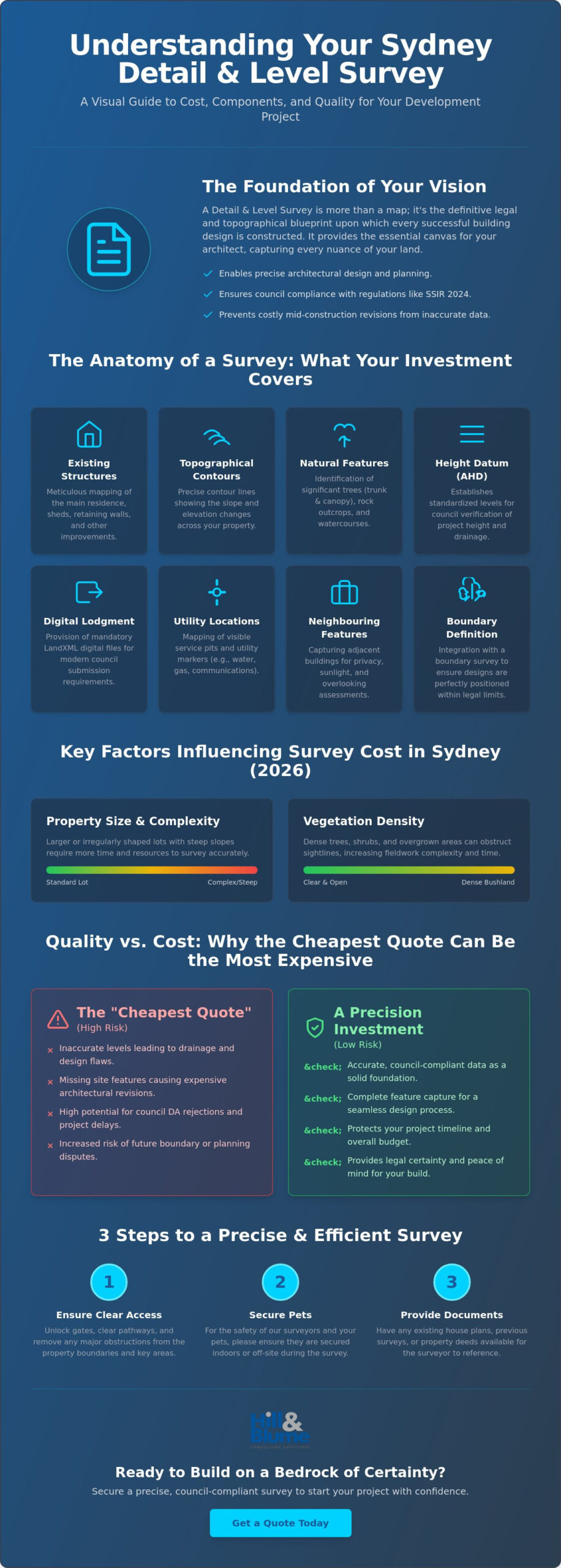
The Anatomy of a Survey: What Your Investment Covers
Think of a survey as the high-definition lens through which your design team views your land. While the detail and level survey cost sydney homeowners encounter represents a financial commitment, it covers an exhaustive list of data points that protect your build. We don’t just look at the surface. We capture the pulse of the property by documenting every existing structure, from the primary residence to the smallest garden shed and weathered retaining wall. This meticulous documentation ensures that nothing is left to chance when the first shovel hits the ground.
Our work also involves a deep respect for the natural landscape. We identify significant trees, rock outcrops, and watercourses that might influence your architectural footprint. According to best practices supported by The Institution of Surveyors NSW, this data must be precise to ensure compliance with local environmental regulations. We also establish the Australian Height Datum (AHD), a standardized level that allows your council to verify your project’s height relative to the rest of the city. This level of technical rigor is what distinguishes a premium survey from a basic sketch.
Essential Site Features Captured
In our harbor city, the relationship between your home and its surroundings is paramount. Capturing the exact location of a tree’s trunk and the spread of its canopy is often a non-negotiable requirement for a Sydney Development Application (DA). This level of detail extends beyond your boundary. We map neighboring structures to facilitate accurate privacy and sunlight assessments, ensuring your new build respects the local character. Accurately mapping utility locations acts as a vital safeguard, preventing catastrophic strikes during excavation that could otherwise derail your timeline and budget. You can explore how these elements fit into our broader professional surveying services to better understand the scope of your specific project.
The Technology Behind the Data
Precision is no longer just about manual measurements. The industry has seen a sophisticated transition from traditional total stations to advanced 3D laser scanning. This technology allows us to capture millions of data points in a fraction of the time. It’s an elegant solution that increases data density while reducing the hours spent on your site. However, the real value isn’t just in the capture. It’s in the professional software processing where we distill this raw data into a clear, actionable plan for your architect. If you’re ready to see how this precision can benefit your unique site, we invite you to reach out for a tailored conversation about your vision.
Calculating the Detail and Level Survey Cost in Sydney
The landscape of property development in 2026 has shifted. As Sydney continues to evolve, the regulatory requirements for land measurement have become more sophisticated. When you’re assessing the detail and level survey cost sydney homeowners often find that a one-size-fits-all approach is rare. While a flat-fee model is common for standard suburban allotments with clear lines of sight, most projects involve a “Complexity Factor.” This factor accounts for the unique character of your land and the professional hours required to capture it accurately. To see how these variables apply to your specific project, you can explore our full range of surveying services.
Understanding the nuances of your site allows for a more transparent partnership. We believe that clarity in the planning phase is the hallmark of a premium experience. By identifying the specific drivers of your investment early, you can move forward with the calm confidence that your project is built on a foundation of professional integrity.
Primary Cost Drivers for Sydney Properties
The physical nature of your site is the most significant variable. Steep blocks, particularly those found in the Northern Beaches or the hilly terrain of the North Shore, require more field hours to establish precise contours. Vegetation density also plays a role. Heavy bushland or dense landscaping can obscure line-of-sight measurements, requiring advanced equipment or additional setups to ensure every rock outcrop and tree trunk is accounted for. Finally, the scale of the property matters. Moving from a 400sqm suburban lot to a large acreage in the outskirts involves a different level of logistical planning and data processing.
Administrative and Regulatory Fees
Beyond the physical site work, several administrative elements influence the final quote. Every professional survey begins with a search of the NSW Land Registry Services (LRS) to verify existing titles and easements. Since January 1, 2026, all surveys must strictly comply with the SSIR 2024 standards. This involves rigorous adherence to the official standards set by the Board of Surveying and Spatial Information of NSW.
The move toward mandatory LandXML digital plan files as of July 1, 2026, has also increased the technical processing required in the office. These digital files, along with standard DWG and PDF formats, ensure your data is ready for immediate use by architects and council certifiers. Professional indemnity insurance also forms a vital part of a surveyor’s overhead, providing you with the peace of mind that your survey is a legally protected document. These combined factors ensure that your architectural plans are backed by data that is as enduring as the home you intend to build.
Quality vs. Cost: Why the Cheapest Quote Can Be the Most Expensive
Choosing the lowest estimate for your project might feel like a victory for your budget, but in the intricate world of Sydney property, a bargain often carries a heavy price. When you’re evaluating the detail and level survey cost sydney providers offer, it’s essential to look beyond the bottom line. A cut-price survey often results in missing site features or inaccurate levels that don’t reveal themselves until you’re deep in the design phase. By then, the cost of redesigning a foundation or repositioning a structure far outweighs the initial savings of a budget quote.
Architects and structural engineers rely on the integrity of our data to perform their own craftsmanship. If a survey file is low-quality or lacks the necessary digital density, these professionals will often reject the data entirely. This leads to double-handling costs where you’re forced to pay for a second, more precise survey to rectify the errors of the first. It’s a frustrating delay that can be easily avoided by prioritizing quality from the very beginning of your journey.
The Registered Surveyor Advantage
In New South Wales, the title of “Registered Surveyor” isn’t merely a professional label; it’s a legal status granted under the Surveying and Spatial Information Act. This registration ensures that the individual responsible for your land data is held to the highest standards of accuracy and ethical conduct. You can understand what a registered surveyor is in NSW and why their oversight is a prerequisite for council certifiers and insurance providers. Without this professional accountability, your survey may not be accepted for DA submission, leaving your project at a standstill.
Identifying Red Flags in Survey Quotes
A quote that seems too good to be true usually is. When reviewing proposals, look for omissions that indicate a lack of thoroughness. Budget providers might exclude mandatory NSW Land Registry Services search fees or fail to account for essential site features like neighboring roof ridges or significant tree canopies. Other red flags include:
- Vague timelines that don’t align with your DA submission schedule.
- A lack of professional indemnity insurance details.
- Quotes that don’t specify compliance with the latest SSIR 2024 regulations.
- Providers who lack specific experience with your local Sydney council’s requirements.
Hill & Blume’s 90-year reputation is built on the belief that precision is the ultimate form of respect for a client’s vision. We don’t just provide a document; we provide the peace of mind that comes from nearly a century of local expertise. When the stakes are high, you deserve a partner who values your project’s future as much as you do. If you’re ready to secure a foundation built on trust and technical excellence, we invite you to request a comprehensive fee proposal tailored to your unique site.
Securing Your Survey: Steps to a Precise Start
Setting your project in motion requires more than just an agreement; it requires preparation. While you now have a clearer picture of the detail and level survey cost sydney homeowners should anticipate, the final step is ensuring your site is ready for the precision it deserves. Early engagement is the most strategic move a property developer can make. It allows us to identify potential boundary issues or topographical challenges before they become expensive roadblocks in your timeline. This proactive approach ensures your architectural vision remains uncompromised from the very first day.
At Hill & Blume, we believe that a successful build is a collaborative journey. Our role is to provide the technical clarity that allows your creativity to flourish. By following a few simple steps, you can ensure that your project begins with the same care and attention to detail that you intend to bring to the final construction.
Preparing Your Property for the Field Team
Efficiency in the field directly impacts the professional fee for your project. We recommend clearing heavy undergrowth before our team arrives. This isn’t merely about tidiness; it’s about improving the line-of-sight for our high-precision equipment. When our surveyors can move freely across the terrain, they can capture more data in fewer site hours. Additionally, ensure we have safe, unobstructed access to all areas of the property, including internal spaces if your project requires them. If you have existing title documents or previous surveys tucked away, providing these early can significantly speed up our research phase. It allows us to focus our energy on the unique nuances of your land rather than searching for basic historical data.
How to Request a Comprehensive Quote
A precise start begins with a detailed inquiry. When you reach out to a professional, including a “Checklist for Success” ensures your quote is as accurate as possible. Include your property address, a brief description of your development goals, and any specific council requirements you’ve already identified. If you’re still weighing your options, you might find it helpful to read our guide on choosing a surveyor in Sydney. This transparency ensures that the detail and level survey cost sydney you receive is comprehensive, reflecting the true scope of work with no hidden surprises later in the project.
Hill & Blume carries a 90-year heritage of serving the Sydney community with distinction. Our promise is one of precision, anchored by deep local expertise and a commitment to your project’s long-term success. We don’t just measure land; we provide the curated experience and technical certainty you need to build with absolute confidence. When you’re ready to lay the first stone of your development, we invite you to request a tailored detail and level survey quote from our expert team. Let’s ensure your Sydney project begins on the most accurate foundation possible.
Building Your Future on a Foundation of Precision
Your property is more than just land; it’s the canvas for your life’s next chapter. We’ve explored how a meticulous survey protects your architectural vision and prevents the costly revisions that arise from “near enough” data. By understanding the detail and level survey cost sydney homeowners invest in, you can move forward with a clear perspective on the technical craftsmanship required for success. Precision isn’t a luxury in the pre-construction phase; it is the legal and topographical insurance policy that ensures your project meets the strict 2026 standards of the SSIR 2024 and LandXML requirements.
With over 90 years of Sydney surveying expertise, our team of Registered Surveyors (NSW) is trusted by the city’s leading architects and developers to deliver excellence. We invite you to partner with Sydney’s trusted surveying authority for your next project and experience the peace of mind that comes from true local authority. Your vision deserves a foundation as enduring as the home you’re about to create. We look forward to helping you take that first, precise step toward your new build with confidence and clarity.
Frequently Asked Questions
How long does a detail and level survey take to complete in Sydney?
Field work for a standard Sydney property usually spans one to two days, with an additional three to five business days dedicated to professional drafting. The total time depends on your site’s unique characteristics, as steep slopes or dense foliage require more deliberate measurements. When considering the detail and level survey cost sydney homeowners often find that this short waiting period is a vital investment in the long-term accuracy of their build.
Do I need a detail and level survey for a simple home extension?
Yes, most Sydney councils require a professional survey for any structural extension to verify that the proposed work complies with height limits and setback regulations. Even for a simple addition, accurate levels are vital for drainage planning and structural integrity. This small investment ensures your design fits perfectly within the existing landscape and meets all local planning controls without the risk of costly mid-project corrections.
Is a topographic survey the same as a detail and level survey?
These terms are largely synonymous within the NSW surveying profession and describe the same essential service. Both a topographic survey and a detail and level survey map the physical nuances and elevations of your property. Whether your architect requests one or the other, the goal is to provide a precise digital twin that informs the detail and level survey cost sydney and ensures a seamless design process.
Will my surveyor need to enter my neighbors property?
Surveyors often need to capture “offset” data from neighboring properties, such as roof ridge heights or window positions, to satisfy council privacy and overshadowing requirements. While we can often gather this data from within your boundary using advanced laser equipment, brief access may be requested. We always handle these interactions with the utmost professional courtesy to maintain your local relationships and ensure a harmonious start to your project. If you’re also managing projects or have family in other regions, such as Melbourne, a thoughtful gift from flowersalley.com.au is a perfect way to maintain those important connections during busy development phases.
How long is a detail and level survey valid for in NSW?
A survey is a snapshot of your land at a specific moment in time. While it doesn’t have a formal expiry date, most Sydney councils and certifiers prefer data that is less than two years old. This ensures that your plans reflect the current state of the property, including any recent changes to landscaping, structures, or neighboring developments that could impact your project’s approval.
Can I use a survey from ten years ago for my new DA?
It’s unlikely that a decade-old survey will be accepted for a new Development Application. Significant topographical changes can occur over ten years, and older surveys won’t comply with the current SSIR 2024 standards or mandatory LandXML requirements. Using outdated data risks a council rejection, making a fresh survey a necessary step for modern compliance and architectural precision.
What file formats will I receive after the survey is finished?
You will receive a comprehensive suite of digital files designed for seamless integration with your design team’s workflow. This typically includes a high-resolution PDF for visual review, a DWG file for your architect’s CAD software, and the mandatory LandXML file. These formats ensure your project meets the 2026 digital lodgment standards required by NSW Land Registry Services and local councils.
Does the cost of a survey include boundary marking with pegs?
Boundary marking is a separate professional service and is not typically included in a standard detail and level survey quote. While a detail survey identifies existing features relative to boundaries, physically pegging the corners requires a formal Boundary Survey. Combining these services during our initial site visit is often the most cost-effective way to secure your project’s legal perimeter and provide total certainty for your builder.
Disclaimer
The information provided in articles published on this website is for general informational purposes only. While we make every effort to ensure the accuracy, completeness, and timeliness of the content, the material is based on our understanding of the industry at the time of writing and may not reflect the most current developments, regulations, or standards. All opinions expressed in our articles are those of the respective authors and do not necessarily represent the official position of the website or its affiliates. The content should not be considered professional, legal or technical advice, and should not be relied upon as a substitute for consultation with qualified professionals