
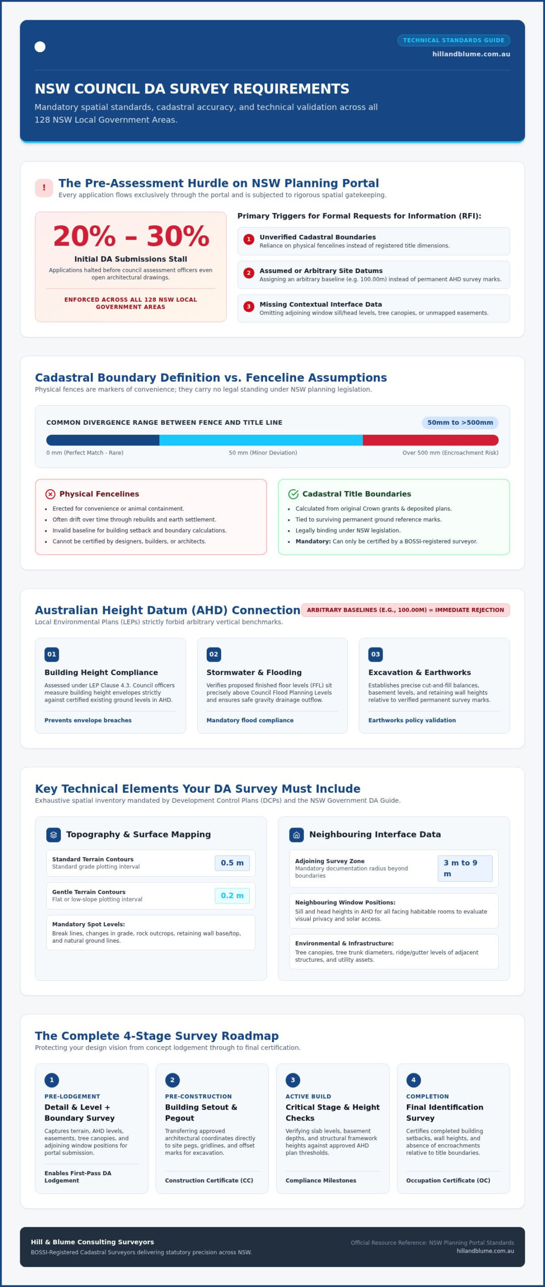
Between 20% and 30% of initial Development Applications lodged on the NSW Planning Portal stall before assessment even begins, tripped up by unverified boundary lines and incomplete spatial data. Understanding the precise da survey requirements nsw councils mandate is often the quiet divide between a seamless approval and months of frustrating, costly delays. You’ve poured immense care and vision into your architectural concepts; the last thing you need is a formal Request for Information halting your progress over unmapped easements, unverified encroachments, or an assumed site datum.
Council approval ultimately hinges on certified cadastral accuracy rather than preliminary design sketches. Mastering these mandatory land survey standards protects your investment and ensures your documentation satisfies assessment officers on the very first pass. In this comprehensive guide, we outline the exact features your Detail and Level survey must capture, from Australian Height Datum levels to neighbouring window sightlines, so you can lodge your application with complete confidence.
Key Takeaways
- Master the essential da survey requirements nsw councils enforce to secure first-pass acceptance on the NSW Planning Portal without administrative hold-ups.
- Pinpoint the mandatory spatial details your plans must capture, including Australian Height Datum (AHD) levels, tree canopies, and neighbouring window sightlines.
- Learn why only a BOSSI-registered land surveyor possesses the legal authority to certify property boundaries under NSW planning legislation.
- Explore the complete four-stage survey roadmap that protects your design vision from initial concept to your final Occupation Certificate.
What Are the Mandatory DA Survey Requirements in NSW?
Every Development Application submitted across the state requires an authentic, registered survey plan before council assessment officers will even open your architectural files. Across all 128 local government areas, lodgements flow exclusively through the NSW Planning Portal, which enforces strict spatial validation criteria. Understanding the fundamental da survey requirements nsw planning authorities mandate is essential because council consent teams immediately reject applications that lack verified boundary lines, relative levels, and topographical contours. Certified surveys form the unshakeable digital truth upon which your architect, structural engineer, and town planner build their vision.
The Legal Role of the Detail and Level Survey
A Detail and Level survey captures the raw spatial reality of your land. It maps existing structures, ground contours, natural rock formations, and service infrastructure with absolute precision. Design teams rely on these verified dimensions to calculate gross floor area, building height envelopes, and cut-and-fill balances under your Local Environmental Plan (LEP). Without this foundation, architectural drawings remain mere artistic impressions. You can explore how our registered specialists deliver these intricate models through our tailored Detail and Level Surveys.
Australian Height Datum (AHD) Connection
Local planning controls strictly forbid assumed or arbitrary site datums. All elevation measurements, surface contours, and structure heights must tie directly into the Australian Height Datum (AHD), derived from permanent government survey marks. AHD levels provide an absolute standard for evaluating critical planning controls:
- Building Height Compliance: Councils measure building height planes under LEP Clause 4.3 against certified existing ground levels.
- Stormwater and Flooding: Precise AHD data proves that proposed finished floor levels sit safely above council Flood Planning Levels.
- Excavation Limits: Retaining walls, basement levels, and cut-and-fill depths require verified vertical benchmarks.
Submitting plans based on an arbitrary baseline, such as assigning a site corner a benchmark of 100.00 metres, triggers immediate rejection by planning officers.
Cadastral Boundary Definition vs Fenceline Assumptions
One of the most dangerous assumptions in residential property development is trusting existing boundary fences. Fences are markers of convenience, rarely built on the true cadastral boundary. They often diverge by anywhere from 50 millimetres to more than half a metre. Only a registered surveyor can legally locate, calculate, and mark boundary positions by cross-referencing original Crown grants, deposited plans, and surviving ground reference marks. Review our professional Boundary Surveys to ensure your design respects true legal title lines before committing to council lodgement.
Key Technical Elements Your Council DA Survey Must Include
Satisfying the strict da survey requirements nsw councils enforce demands far more than tracing allotment boundaries. Local Environmental Plans (LEPs) and Development Control Plans (DCPs) mandate an exhaustive spatial inventory of both your property and its immediate surroundings. As detailed in the official NSW Government guide to the DA process, council assessment officers rely on these certified parameters to scrutinise environmental impact, overshadowing, and structural bulk long before ground breaks.
Topography, Contours, and Natural Ground Levels
Terrain mapping provides the geometric foundation for your entire proposal. Surveys must display continuous contour intervals, typically plotted at 0.5-metre increments or 0.2-metre intervals on gentle terrain. Spot levels must pinpoint break lines, changes in grade, retaining walls, rock outcrops, and existing surface improvements. These measurements allow assessment officers to verify natural ground lines, ensuring your architect’s cut-and-fill calculations and stormwater drainage slopes comply with local earthworks policies.
Neighbouring Structures and Sensitive Interface Data
A frequent trigger for costly planning delays is failing to capture adjoining land context. Council assessment officers must evaluate solar access and visual privacy across allotment edges. Consequently, your survey plan must document external features within 3 to 9 metres of your boundary line:
- Window Positions: Specific sill and head heights in AHD for all facing habitable rooms.
- Roof Geometry: Ridge, eaves, and parapet elevations of adjacent residences.
- Finished Floor Levels: Adjoining ground-floor and upper-floor living heights.
- External Built Elements: Existing balconies, privacy screens, and pool coping levels.
Accurate interface data prevents contentious disputes during the public notification period, shielding your application from neighbouring objections.
Vegetation, Services, and Underground Infrastructure
Local councils enforce rigorous Tree Preservation Orders aligned with Australian Standard AS 4970-2009. Surveyors must plot the exact trunk centre, diameter at breast height (DBH), canopy spread, and ground level for all significant trees on your allotment and within 5 metres of the perimeter. Overlooking a single mature tree can derail an application for months.
Visible utility infrastructure demands equal precision. Your plan must identify sewer inspection shafts, stormwater pits, hydrants, electrical connection points, and telecommunications pits. Any registered easements, rights-of-carriageway, or covenants noted on your title deed must be precisely plotted against site features. If you are preparing design documentation, you can connect with our experienced surveyors to coordinate a comprehensive site analysis that captures every regulatory nuance.
Why Councils Require a Registered Land Surveyor in NSW
In New South Wales, property boundaries are legal constructs rather than simple physical dimensions. While draftspersons, building designers, and civil engineers produce exceptional design work, none possess the statutory licence to determine, re-establish, or certify property boundary lines. Under Section 12 of the Surveying and Spatial Information Act 2002, only a professional registered with the Board of Surveying and Spatial Information (BOSSI) holds the legal authority to sign off on boundary definitions. Meeting the da survey requirements nsw councils demand begins by partnering with an accredited registered surveyor who carries statutory responsibility for cadastral precision.
The Legal Protection of Registered Survey Plans
A certified survey is a legally binding document that protects your capital investment against future liabilities. Registered land surveyors carry comprehensive professional indemnity and statutory accountability under state law. Councils routinely refuse submissions when boundary definitions stem from unregistered sources or unchecked title assumptions. Securing an authentic cadastral survey prior to design documentation eliminates boundary encroachment risks, ensuring multi-million-dollar footings never cross adjoining property lines.
Avoiding Requests for Information (RFIs) and Council Refusal
Incomplete survey submissions create friction the moment your application reaches assessment. When documentation uploaded to the NSW Planning Portal lacks critical spatial data, council assessment officers issue a formal Request for Information (RFI). This action immediately triggers a statutory “stop the clock” on your application.
- Missing Benchmark References: Unsubstantiated elevation baselines prevent officers from assessing building height envelopes.
- Unverified Easements: Failing to plot drainage reserves or rights-of-carriageway halts engineering sign-offs.
- Assessment Delays: Resolving an RFI frequently adds eight to twelve weeks to your planning timeline while consultants revise architectural overlays.
Engaging a seasoned professional who understands local council nuances ensures your documentation clears preliminary portal screening smoothly, keeping your construction milestones squarely on schedule.
From NSW Planning Portal Lodgement to Construction: The Survey Roadmap
Transforming an architectural concept into physical reality requires unified spatial precision across every phase of approval. A common misstep is treating survey work as an isolated hurdle solely for portal lodgement. In reality, fulfilling initial da survey requirements nsw authorities set out establishes the digital baseline for the life of your project. Aligning your cadastral data early eliminates duplicated site visits, preserves design intent, and creates a seamless bridge from town planning consent to building certification.
Step 1: Commissioning the DA Detail and Boundary Survey
Engage a registered land surveyor at the very inception of your design brief. Your surveyor obtains historical deposited plans and titles, resolving boundary locations and documenting physical site conditions. The resulting deliverables, supplied as detailed 2D CAD files and 3D digital terrain models, provide your architect with the certified canvas needed to draft compliant envelopes from day one.
Step 2: Integrating Survey Data with Architectural Plans
Architects and engineers overlay proposed floorplates, subterranean basements, and structural footings directly onto the certified survey base. Council planners inspect these digital overlays to evaluate regulatory compliance:
- Boundary Setbacks: Validating that proposed walls sit strictly within statutory side and rear setbacks.
- Gross Floor Area: Calculating floor space ratios against registered allotment areas rather than approximated titles.
- Consultant Alignment: Confirming stormwater drainage diagrams, landscape schemes, and structural footings reference identical site levels.
Step 3: Moving Forward to Construction Set-Out and WAE
Once council grants development consent, spatial oversight shifts from desktop evaluation to physical ground control. Before breaking ground, a registered surveyor conducts a construction set-out survey, transferring computer-aided blueprints onto the dirt with pinpoint recovery pegs and profile offsets for your builder. During structural works, intermediate formwork certificates confirm slab levels match stamped plans.
Prior to the issuing of your Occupation Certificate, council or private certifiers mandate a final Work-as-Executed (WAE) survey to confirm stormwater drainage, on-site detention systems, and finished eaves match the approved design. You can explore our full range of certified Land Surveying Services to ensure your project maintains compliance from initial site appraisal to completion. When you are ready to establish a flawless cadastral base for your upcoming submission, request a comprehensive survey consultation with our registered team.
Securing Your DA Approval with Hill & Blume’s Heritage of Precision
A successful development application represents both a substantial financial commitment and a refined architectural vision. Achieving council approval shouldn’t be an exercise in anxiety or administrative friction. At Hill & Blume, we’ve provided authoritative land surveying expertise across New South Wales since 1932. Bringing over 90 years of continuous cadastral experience to every project, our registered land surveyors collaborate closely with architects, developers, and property owners, ensuring every submission satisfies the exact da survey requirements nsw councils enforce.
Deep Local Authority Across Sydney, Newcastle, and Central Coast
Planning frameworks vary markedly between local government areas. The coastal hazards and steep slopes of the Northern Beaches or Waverley present vastly different planning considerations than the heritage alignments of the City of Sydney or expanding urban infill across Newcastle and the Central Coast. Our practitioners understand these distinct municipal environments intimately.
Our private archive of historical survey records dating back nearly a century provides an extraordinary foundation for modern approvals. When dealing with complex parent titles, re-aligned boundaries, or difficult topography, this extensive knowledge base removes ambiguity. We re-establish legal boundaries with unwavering precision, resolving potential boundary disputes before plans reach an assessment officer’s desk. Learn more about how we safeguard property integrity through our comprehensive cadastral and detail surveying services.
Your Trusted Partner for Frictionless Planning Approvals
Cadastral surveying is fundamentally a collaborative discipline. We don’t simply capture field coordinates; we deliver complete spatial clarity tailored to your broader design team. Our registered surveyors produce digital 2D CAD drawings and 3D spatial models formatted for seamless integration into your architect’s drafting software. Every contour, level, and setback is structured to align with digital portal validation checks, avoiding the costly delays that so often disrupt project schedules.
Should council consent officers raise technical queries during assessment, our senior team responds promptly with verified data to keep your application moving forward. This boutique, relationship-focused approach ensures your project progresses smoothly from concept design to planning determination. When you’re ready to establish the legal foundation for your next project, partner with the specialists who understand how to meet every technical aspect of da survey requirements nsw planning teams mandate.
Build Your Development on Cadastral Certainty
Securing a rapid, friction-free planning determination depends entirely on the integrity of your initial spatial data. Meeting the mandatory da survey requirements nsw consent authorities enforce means establishing true cadastral boundaries, referencing permanent Australian Height Datum marks, and capturing sensitive neighbouring interfaces long before formal portal lodgement. When your spatial foundation is accurate, your entire design and engineering team moves forward in perfect harmony.
Founded in 1932, Hill & Blume brings over 90 years of dedicated NSW surveying excellence to your side. Our fully licensed registered land surveyors service Sydney, Newcastle, and the Central Coast, pairing boutique care with a flawless council compliance record that shields your project from costly planning portal delays. We treat every allotment with the meticulous care it deserves, giving you complete confidence from initial concept through to the issue of your final certificate.
Take the decisive step toward safeguarding your vision. Partner with Hill & Blume for your council-compliant DA survey and begin your build on solid, certified ground.
Frequently Asked Questions
Is a detail and level survey mandatory for every NSW Development Application?
Yes, council consent authorities across NSW mandate a certified Detail and Level survey for virtually all Development Applications involving new building work or site alterations. Standard da survey requirements nsw checklists state that council planning officers cannot evaluate building height planes, stormwater paths, or setback compliances without registered terrain data. Submitting an application without one guarantees an immediate administrative halt on the NSW Planning Portal.
Can my building designer or architect complete the site survey instead of a surveyor?
No, building designers and architects cannot legally certify boundary lines or site levels for a DA. Under the Surveying and Spatial Information Act 2002, only a Registered Land Surveyor registered with BOSSI has the statutory qualification to establish legal title boundaries. While designers create the proposed concepts, they must build their schemes on a certified survey plan prepared by a licensed professional.
How long is a DA survey valid when submitting to a NSW council?
Most local councils across Sydney, Newcastle, and the Central Coast require survey plans to be dated within one to two years of portal submission. Over time, ground levels change through landscaping, boundary fences shift, and neighbouring structures alter privacy sightlines. If your survey exceeds council timeframes or subsequent physical work has taken place on site, consent officers will require an updated survey before continuing assessment.
What happens if my existing fence is not on the legal boundary line?
Fences rarely align perfectly with legal title boundaries, often straying several inches or more. When your survey reveals an off-line fence, your architect must design proposed setbacks strictly from the legal boundary line, not the physical fence. Building off the fence line risks encroachment, neighbour disputes, or building certificate refusals. Identifying these discrepancies early allows you to resolve boundary issues before pouring concrete.
Why must my Development Application survey connect to the Australian Height Datum?
Councils reject temporary or assumed vertical datums because planning controls demand regional consistency. Connecting to the Australian Height Datum provides an absolute elevation level tied to permanent state survey marks. Consent officers rely on this shared baseline to assess building height envelopes under Clause 4.3 of your LEP, confirm floor levels sit above local flood planning benchmarks, and ensure stormwater runoff discharges correctly across municipal catchments.
What is the difference between a DA survey and a Complying Development survey?
Both pathways require registered spatial data, but meeting da survey requirements nsw councils establish often demands wider contextual mapping. DA surveys typically require detailed neighbouring window locations, roof heights, and tree canopy spreads across adjacent lots to satisfy discretionary Development Control Plans. Complying Development (CDC) surveys focus primarily on strict, quantitative boundary clearances and height limits set under state-wide SEPP legislation.
Do I need a new survey if I already have an older identification report?
In most instances, yes. An identification report is a specific sketch created during property conveyancing to confirm existing structures sit within title boundaries. It rarely includes comprehensive contour levels, AHD connections, underground services, or neighbouring window elevations required for development assessment. Councils require a dedicated Detail and Level survey to properly assess the spatial impact of any proposed new building works.
Disclaimer
The information provided in articles published on this website is for general informational purposes only. While we make every effort to ensure the accuracy, completeness, and timeliness of the content, the material is based on our understanding of the industry at the time of writing and may not reflect the most current developments, regulations, or standards. All opinions expressed in our articles are those of the respective authors and do not necessarily represent the official position of the website or its affiliates. The content should not be considered professional, legal or technical advice, and should not be relied upon as a substitute for consultation with qualified professionals