

The most ambitious architectural visions don’t fail during construction; they unravel in the quiet millimeter discrepancies of an unverified baseline. If you feel anxious about Sydney council DA rejections, or dread unexpected excavation costs on a sloping parcel, your caution is well justified. Commissioning a precise contour survey Sydney certifiers and design professionals can depend on is far more than an administrative formality. It is the essential foundation that translates complex natural ground levels into enduring architectural clarity.
In this guide, discover how an accurate contour survey protects your Sydney build, satisfies council regulations, and unlocks your property’s full architectural potential. You’ll gain immediate clarity on the critical distinctions between boundary, detail, and contour surveys, unpack Complying Development Certificate (CDC) height thresholds tied to the Australian Height Datum, and discover how certified spatial data ensures your project moves seamlessly from concept to reality.
Key Takeaways
- Understand how a certified contour survey Sydney design professionals rely on establishes true Australian Height Datum levels, transforming natural site contours into an unassailable baseline.
- Learn how precise existing ground level documentation protects your DA or CDC submission from height plane non-compliance and expensive structural revisions.
- Explore the technical journey from historical NSW Land Registry Services deposited plans to layered, BIM-compatible CAD models tailored for your architect.
- Discover why New South Wales statutory regulations mandate a BOSSI-registered land surveyor for boundary re-establishment, safeguarding your investment against encroachment disputes.
- See how a consultative, heritage-backed surveying partner brings calm confidence and tailored precision to Sydney’s most complex terrain.
What Is a Contour Survey & Why Sydney Properties Need It?
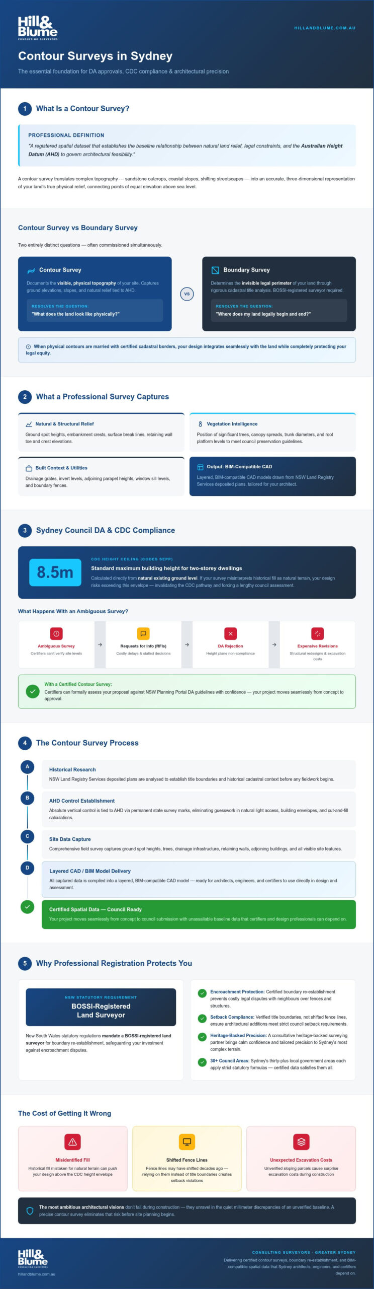
Every Sydney property tells a story written across sandstone outcrops, coastal slopes, and shifting streetscapes. A contour survey translates this complex topography into an accurate, three-dimensional representation of your land’s true physical relief. By mapping the undulating surface through a series of continuous lines, each connecting points of equal elevation above sea level, your survey captures the precise geometry of your site. In professional practice, a standard contour line and elevation intervals establish an intelligible spatial hierarchy across the terrain, transforming raw vertical changes into actionable design insights.
For Australian property developers and discerning homeowners, a contour survey is defined as follows: a registered spatial dataset that establishes the baseline relationship between natural land relief, legal constraints, and the Australian Height Datum (AHD) to govern architectural feasibility.
Sydney architects depend on this exact dataset before drafting their first conceptual lines. Without absolute vertical control tied to AHD via permanent state survey marks, calculating natural light access, building envelope envelopes, and cut-and-fill balances becomes guesswork. A tailored contour survey Sydney certifiers accept eliminates that uncertainty before site planning begins.
Key Features Captured in a Professional Topographic Survey
A comprehensive detail and level survey documents far more than undulating soil. It captures the full physical context of your parcel, delivering the spatial clarity your design team needs to navigate tight urban footprints:
- Natural and structural relief: Ground spot heights, embankment crests, surface break lines, and retaining wall toe and crest elevations.
- Vegetation intelligence: Position of significant trees, canopy spreads, trunk diameters, and root platform levels to meet council preservation guidelines.
- Built context and utilities: Visible drainage grates, invert levels, adjoining parapet heights, window sill levels, and boundary fences.
These measured parameters form the foundation of our broader suite of surveying services, providing the spatial certainty required across Greater Sydney.
Contour Survey vs Boundary Survey: Understanding the Distinction
While often commissioned simultaneously, contour surveys and boundary surveys resolve two entirely distinct questions. A contour survey documents visible, physical topography. In contrast, a boundary survey determines the invisible legal perimeter of your land through rigorous cadastral title analysis.
Designing modern architectural additions within strict setbacks requires verified title boundaries, not simply existing fence lines that may have shifted decades ago. When physical site contours are married with certified cadastral borders, your design integrates seamlessly with the land while completely protecting your legal equity.
Navigating Sydney Council DA and Complying Development Requirements
Securing planning permission across Sydney’s thirty-plus local government areas is rarely a routine rubber-stamping process. Municipal councils and private certifiers apply strict statutory formulas to evaluate site coverage, sunlight envelopes, and building envelope planes. Topographic data forms the bedrock of these assessments. When you lodge through the NSW Planning Portal, certifiers evaluate your proposal against the official NSW Development Application guidelines, requiring unassailable site levels before formal assessment can even begin. An ambiguous contour survey Sydney certifiers struggle to interpret leads directly to costly Requests for Information (RFIs), stalled determinations, or outright rejection.
Precision is equally unforgiving under the State Environmental Planning Policy (Codes SEPP). For Complying Development Certificate (CDC) applications, maximum building heights, such as the standard 8.5-metre ceiling for two-storey dwellings, are calculated directly from natural existing ground level. If your survey misinterprets historical fill as natural terrain, your design risks exceeding building height envelopes, rendering a CDC pathway invalid and forcing your project into a lengthy council assessment.
Satisfying Local Environmental Plans and Building Height Controls
Local Environmental Plans (LEPs) and Development Control Plans (DCPs) mandate that building height planes project inward from existing natural ground levels. A minor discrepancy on a steep slope can artificially elevate an architectural ridge line beyond statutory allowances. Discovering this issue halfway through framing means costly structural roof modifications or an expensive Section 4.55 modification application. Our comprehensive detail and level surveys establish an airtight vertical baseline, giving your design team complete confidence across every elevation.
Managing Sloping Sites, Excavation, and Overland Flow Paths
Sydney’s varied geology, from the Hawkesbury sandstone shelves of the Northern Beaches and Eastern Suburbs to reactive Wianamatta shales across the Inner West, creates intricate drainage challenges. Sites falling away from the street require precise engineering to manage stormwater, calculate cut-and-fill balances, and mitigate flood risks:
- Earthworks optimization: Topographic accuracy verifies that cuts and fills remain within CDC excavation thresholds, avoiding unexpected rock-sawing expenses.
- Retaining structures: Detailed spot levels inform structural engineers where retaining walls exceeding 600 mm require certified design and structural footings.
- Overland stormwater paths: Surface gradients map natural catchments, ensuring drainage engineers direct overland flows away from neighbouring foundations.
If you’re preparing a new build or substantial renovation, you can speak with our registered team to discuss how tailored site levels ensure compliance across your chosen planning pathway.
The Step-by-Step Contour Survey Process: From Research to CAD Model
Delivering an exceptional topographic plan requires a deliberate blend of historical research and modern geomatic engineering. Far from a hurried afternoon with a laser level, every robust contour survey Sydney design professionals rely on follows a four-stage process. This approach moves methodically from archival investigation to precision digital modeling, ensuring complete structural and legal alignment before construction begins.
Preliminary Historical Research and Cadastral Mark Recovery
The journey begins long before setting foot on your block. Our surveyors interrogate registered Deposited Plans (DPs) and strata records held by NSW Land Registry Services. We identify surrounding survey reference monuments, street alignments, and state survey marks catalogued in the Survey Control Information Management System. By retrieving these historical records, we securely tie your property’s vertical levels to Australian Height Datum benchmarks, guaranteeing legal and spatial consistency.
Precision Fieldwork Using Modern Total Stations and GNSS
Once on site, registered survey teams utilize millimeter-accurate robotic total stations alongside survey-grade GNSS equipment. Instead of capturing generic terrain lines, our field capture targets the nuances that directly influence council planning approvals and architectural feasibility:
- Adjoining structural envelopes: We measure neighbouring ridge lines, gutter eaves, finished floor levels, and privacy-sensitive window sill heights to inform shadow diagram calculations.
- Ground interface points: Detailed spot heights capture changes in slope, exposed sandstone bedrock, retaining wall alignments, and kerb profiles.
- Subsurface infrastructure entries: We record council stormwater invert levels, inspection pits, and utility connections across the street frontage.
Architectural Deliverables: 2D Plans, 3D Surfaces, and CAD Integration
Raw spatial measurements are synthesized through rigorous drafting protocols and multi-tier quality assurance. We generate digital terrain models (DTM) and triangulated irregular networks (TIN) that reflect complex natural undulations with absolute fidelity. The resulting deliverables are supplied as clean, layered DWG files and high-resolution PDFs formatted specifically for seamless import into Revit, ArchiCAD, and BIM workflows. This eliminates software translation errors and provides your architect with an immaculate digital canvas.
Evaluating Surveying Partners: Why Professional Registration Protects Your Investment
Engaging a surveying firm shouldn’t feel like ordering a generic commodity off a shelf. In an industry increasingly crowded with high-volume operators competing solely on turnaround speed, high-end residential builds demand a consultative approach. A site plan isn’t merely an administrative checkbox. It represents the legal and physical framework governing multi-million-dollar architectural investments. When choosing a partner for your contour survey Sydney project, technical qualifications and local institutional experience separate lasting peace of mind from catastrophic boundary disputes.
Boutique consultancies prioritize bespoke technical oversight over transaction volume. They pair meticulous cadastral analysis with deep regional familiarity, understanding how Sydney’s micro-topography, sandstone shelves, and varied council planning cultures impact real-world constructability. Backed by extensive professional indemnity insurance and rigorous quality assurance, a dedicated surveying consultancy protects your equity before excavation machinery arrives on site.
The Legal Role of a Registered Land Surveyor in NSW
Under the Surveying and Spatial Information Act 2002, only a surveyor registered with the Board of Surveying and Spatial Information (BOSSI) has statutory authority to re-establish property boundaries. While unaccredited technicians can operate survey instruments to map slopes, certifiers, municipal councils, and the Land and Environment Court demand sign-off from an accredited professional whenever proposed structures sit near legal setbacks. Engaging a Registered Land Surveyor guarantees that your contour and level data rests upon an unassailable legal foundation.
Key Questions to Ask Before Engaging a Surveying Practice
Before commissioning site measurements for an upcoming build or renovation, pose these essential questions to prospective firms:
- Who signs off on the data? Verify that a BOSSI-registered land surveyor personally oversees the field capture and applies their formal professional seal to the documentation.
- How are digital files supplied? Ensure deliverables arrive as layered CAD files and 3D surface models tailored for direct import into your architect’s drafting software, avoiding translation errors.
- How does the team handle complex terrain? Ask how steep slopes, sandstone ledges, or dense tree canopies will be mapped to ensure spot heights reflect natural ground level rather than surface debris.
If you value enduring precision and consultative guidance for your upcoming build, contact our registered surveyors to discuss your site’s specific requirements.
Partnering with Hill & Blume: Enduring Precision for Sydney Developments
Great architecture emerges from a deep dialogue between natural landforms and built structures. When embarking on an ambitious residential build or sensitive redevelopment, you need a surveying team that values craftsmanship over volume. Hill & Blume approaches every parcel with the care it deserves. By pairing time-honoured cadastral expertise with contemporary geomatics, our team transforms raw site relief into a pristine spatial canvas, giving your design team complete freedom to innovate without compliance friction.
Our practice delivers a collaborative partnership model. We coordinate directly with your architect, structural engineer, and town planning consultants, speaking their technical language from day one. Rather than supplying generic linework, we tailor every contour survey Sydney projects demand to the exact software specifications and layered CAD formats your consultants use daily. Operating across Greater Sydney, Newcastle, and the Central Coast, we bring calm confidence and seasoned regional mastery to every stage of your site journey.
Nine Decades of Surveying Excellence Across New South Wales
Founded in 1932, Hill & Blume brings over nine decades of continuous practice to New South Wales property development. This enduring history provides an invaluable archival perspective when untangling complex historical title boundaries, old system land parcels, and waterfront foreshore alignments. We treat precision as an art form. Our fully accredited Registered Land Surveyors deliver compliance-ready spatial datasets that stand up to the most demanding municipal council assessments, protecting your site equity across generations.
Initiating Your Contour Survey: Next Steps with Our Team
Commissioning your site survey is designed to be seamless, transparent, and completely aligned with your project timeline. Here is how we initiate your engagement:
- Consultative scoping: We review your project aspirations, council planning overlays, and site conditions to establish the precise detail and level parameters required.
- Integrated consultant collaboration: Our registered practitioners liaise directly with your design professionals to ensure spot heights, grid alignments, and tree preservation details seamlessly match their digital design environments.
- Rigorous delivery: You receive an immaculate spatial dataset, backed by registered cadastral oversight and ready for immediate DA or CDC submission.
Explore how our tailored surveying services provide the enduring foundation your project deserves, ensuring every contour, boundary, and level is captured with uncompromised accuracy.
Ground Your Vision in Enduring Site Precision
Every exceptional home begins with a deep respect for the land beneath it. By establishing an unyielding baseline tied to the Australian Height Datum, your architectural vision gains immediate protection against boundary disputes, council delays, and unforeseen excavation expenses. Meticulous site levels don’t simply satisfy statutory planning requirements; they give your design team the creative freedom to craft spaces that respond naturally to their physical setting.
Serving Sydney, Newcastle, and the Central Coast with distinction since 1932, Hill & Blume brings over nine decades of cadastral mastery to your project. Our accredited Registered Land Surveyors deliver the boutique, precision-led oversight trusted by leading residential architects and discerning homeowners across New South Wales. When you invest in a contour survey Sydney authorities respect without hesitation, you safeguard your equity from the ground up.
Take the defining first step for your property. Request a bespoke contour survey consultation with Hill & Blume today and ground your next build in complete certainty.
Frequently Asked Questions
How much does a contour survey typically cost for a Sydney residential property?
Surveying fees depend on the specific physical and legal variables of your parcel rather than a uniform flat rate. Key factors influencing the scope include total site area, the degree of fall across the terrain, vegetation density, and whether existing boundary marks can be recovered. A sloping waterfront block with heavy tree canopy naturally requires more extensive field measurement and cadastral analysis than a level urban lot.
Can an architect design a home without an official contour survey?
No responsible architect will design beyond preliminary sketches without certified site levels. Accurate spatial data dictates structural engineering, cut-and-fill limits, floor heights, and shadow projections. Attempting to draft construction drawings from unverified terrain assumptions almost always triggers costly redesigns once actual elevations reveal site drainage constraints or height limit breaches during formal council lodgement.
What is the difference between an identification survey and a contour survey?
An identification survey reports on property boundaries, existing structures, and potential boundary encroachments relative to title lines, often used for property conveyancing. In contrast, a contour survey maps vertical elevation changes across the ground surface, capturing topographic relief, spot heights, and built features to guide new architectural and landscape planning.
How long does it take to complete a contour survey in Sydney?
Fieldwork for a standard residential allotment typically requires several hours on site with robotic instruments. Processing the spatial observations, conducting cadastral reconciliation against registered Deposited Plans, and drafting layered CAD models generally takes between one and two weeks. Sites with severe slopes or intricate adjoining parapets may require additional technical drafting time.
Why does Sydney council require contour levels to be tied to AHD?
Sydney councils require the Australian Height Datum (AHD) to maintain a universal vertical benchmark across all urban planning. Tying your contour survey Sydney plans to permanent state survey marks lets certifiers reliably verify building envelope compliance, evaluate stormwater drainage schemes against neighbouring catchments, and accurately evaluate potential overland flood impacts.
Will a contour survey show tree canopy spreads and neighbouring window locations?
Yes, a comprehensive detail and level survey documents significant tree trunks, root zones, and canopy spreads within the site and across nearby boundaries. It also captures neighbouring window sills, finished floor levels, and roof ridgelines, which your architect requires to demonstrate privacy compliance and model precise sunlight shadows for planning approval.
Is a contour survey valid for Complying Development Certificate (CDC) applications?
Yes, a certified survey referencing Australian Height Datum levels is mandatory for Complying Development Certificate submissions. Accredited private certifiers rely on the survey’s existing ground level baselines to ensure the proposal strictly respects statutory maximum building heights, boundary setbacks, and excavation limits set out under the NSW Housing Code.
Disclaimer
The information provided in articles published on this website is for general informational purposes only. While we make every effort to ensure the accuracy, completeness, and timeliness of the content, the material is based on our understanding of the industry at the time of writing and may not reflect the most current developments, regulations, or standards. All opinions expressed in our articles are those of the respective authors and do not necessarily represent the official position of the website or its affiliates. The content should not be considered professional, legal or technical advice, and should not be relied upon as a substitute for consultation with qualified professionals