
What if the most expensive mistake in your property development isn’t the physical construction, but a single line drawn incorrectly on a digital plan years before the first brick is laid? You’ve likely spent months scouting the perfect location in Sydney or the Central Coast, only to find that avoiding common subdivision mistakes nsw requires more than just a keen eye for land. It demands a deep respect for the legal and physical “ghosts” that reside within the soil’s history. We understand that the path to a successful title registration can often feel like a gauntlet of unforeseen council delays and sudden budget blowouts.
You deserve a process that feels as seamless as the lifestyle you’re creating. This guide provides a definitive 2026 developer’s checklist to help you handle the latest Planning System Reforms and mandatory LandXML digital requirements with absolute clarity. We’ll explore how to secure a smooth DA approval, maximise your lot yield, and manage the new Housing and Productivity Contribution rates without compromising your project’s integrity. By the end of this article, you’ll have the technical insight needed to transform complex regulatory hurdles into a clear, profitable roadmap for your next boutique development.
Key Takeaways
- Understand why a Section 10.7 certificate is more than just a zoning label and how to navigate local council lot size restrictions to protect your yield.
- Learn why physical markers like old fences are often misleading and how a Registered Surveyor ensures your boundaries are legally sound.
- Master the nuances of Section 88B instruments to ensure easements and covenants are established correctly from the outset of your project.
- Discover a “Surveyor First” strategy for avoiding common subdivision mistakes nsw, designed to safeguard your investment against 2026 regulatory shifts.
- Clarify the critical differences between Development Consent and the final Subdivision Certificate to ensure a seamless path to title registration.
The High Cost of Subdivision Errors in NSW
In the 2026 NSW property market, precision is your most valuable currency. With the Housing and Productivity Contribution rates now fully indexed, a single miscalculated lot can turn a profitable venture into a deficit. Avoiding common subdivision mistakes nsw begins with acknowledging that the margin for error has effectively vanished. When you face project rejection or mounting holding costs due to a minor technical oversight, the financial sting is only part of the burden. The psychological toll of “DIY” planning often leads to developer burnout, where the dream of creating a legacy is overshadowed by endless red tape.
Engaging a Registered Surveyor isn’t merely a regulatory hurdle; it’s your primary defense against these outcomes. In NSW, only a Registered Surveyor is legally authorized to sign off on subdivision plans. This expertise acts as a seal of quality, reassuring both the Council and your financial backers that the project is anchored in reality. It provides a sense of calm confidence that your investment is protected by 90 years of local technical wisdom.
Why NSW Subdivision is Unique
The Subdivision of land in our region is governed by the intricate layers of the Environmental Planning and Assessment Act. Every Local Government Area (LGA) from Sydney to Newcastle operates under its own Local Environment Plan (LEP) and Development Control Plan (DCP). These documents dictate everything from minimum lot sizes to setbacks. When you combine these legal complexities with Sydney’s unique, undulating topography, you realize why a “one-size-fits-all” approach fails. Hill & Blume brings 90 years of local insight to these challenges, ensuring your vision aligns with both the soil and the law.
The ‘Hidden’ Costs of Incorrect Site Data
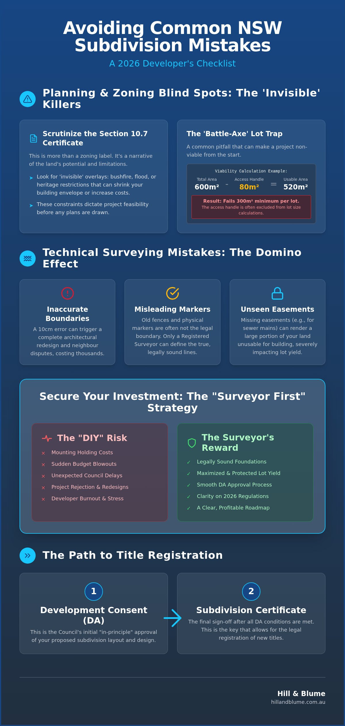
Inaccuracy is a silent thief. A boundary error as small as 10cm can trigger a domino effect, requiring complete architectural redesigns or legal disputes with neighbours. Missing easements on a building envelope can render a portion of your land useless, while inaccurate contour data often leads to massive earthworks blowouts that weren’t in your initial feasibility study. Utilizing professional surveying services early ensures you have a “truth” to build upon. By engaging an expert at the outset, you mitigate these risks, transforming potential disasters into a controlled, elegant progression toward your goals. Precision saves your profit.
Planning and Zoning Blind Spots: The ‘Invisible’ Killers
Your vision for a property begins with the Section 10.7 Certificate. Don’t treat it as a mere formality or a simple zoning label. It’s a complex narrative of the land’s potential and its limitations. One of the most effective ways of avoiding common subdivision mistakes nsw is looking beyond the primary residential code. You must scrutinize the fine print for bushfire, flood, or heritage overlays that can suddenly restrict your building envelope or mandate expensive, specialized construction materials. These constraints are often ‘invisible’ during a casual site walk, yet they dictate the feasibility of your entire development.
The ‘battle-axe’ lot is a classic example of a hidden trap that catches many aspiring developers off guard. In many Sydney and Central Coast councils, the access handle cannot be included in your minimum lot size calculation. If you purchase a 600sqm block needing a 300sqm minimum for each new lot, but the handle takes up 80sqm, you’ve already lost the project’s viability before the first application is lodged. These nuances are why we emphasize a discerning, detail-oriented approach from the very first day of your due diligence.
Zoning and Density Pitfalls
Understanding the nuance between R2 Low Density and R3 Medium Density is vital for your lot yield. While an R3 zone might suggest higher density, specific Development Control Plans (DCPs) often have unique rules for ‘Dual Occupancy’ versus ‘Torrens Title’ subdivisions. You should always consult the Lot Size Map on the NSW Planning Portal to verify the exact requirements for your specific street. Relying on automated reports can be risky. They often fail to capture pending amendments or site-specific nuances that a specialized local authority would spot instantly.
Infrastructure and Access Errors
Infrastructure often dictates design more than aesthetics do. Sydney Water assets, particularly sewer mains and large encumbrances, can significantly impact where you’re permitted to build. While ‘Dial Before You Dig’ provides a helpful starting point, it’s never a substitute for a professional Detail and Level survey. A physical survey identifies the exact location and depth of services, ensuring your architectural plans are grounded in reality. Verify the legal nature of your access too. There’s a profound difference between a dedicated public road and a private ‘Right of Way’ or easement. If these legal tethers aren’t managed correctly, you may find yourself in a costly dispute. If you’re feeling uncertain about your site’s constraints, reach out to our team for a considered conversation about your property’s future.
Technical Surveying Mistakes: Beyond the Boundary Pegs
While zoning maps provide the legal framework, the physical reality of your land is where most projects face their hardest tests. A common trap for developers is assuming that physical markers, like a weathered timber fence or a row of established trees, represent the true legal boundary. Relying on these “ghost” markers is a recipe for legal disaster, especially in older Sydney suburbs where decades of slight shifts can lead to significant discrepancies. Avoiding common subdivision mistakes nsw requires a shift in perspective: the fence is merely a suggestion; the registered plan is the law.
The transition to mandatory LandXML digital plan files as of July 1, 2026, means there is no longer room for manual error in your lodgements. You must distinguish between the “Draft Plan” used for your initial application and the “Final Plan” required for lodgement with NSW Land Registry Services (LRS). Lodging with incorrect technical data can result in the LRS rejecting your plan, forcing you back to the start and adding months of holding costs. Identifying encroachments early is equally vital. Whether it’s a neighbour’s garage overhanging your site or your own proposed driveway clipping a boundary, these issues must be resolved before they become permanent fixtures of a legal dispute.
Boundary Identification Errors
In NSW, only a Registered Surveyor has the legal authority to define and certify your property boundaries. This is not just a professional preference; it’s a statutory requirement. Without this certification, your subdivision cannot proceed to title registration. In historic areas, you may encounter “Adverse Possession” claims, where long-term occupation by a neighbour might challenge your perceived land area. When survey pegs are missing, don’t attempt to guess their location. A professional identification survey restores certainty, ensuring your project rests on a foundation of absolute accuracy rather than historical guesswork.
Contour and Topographic Failures
Precision on the horizontal plane is only half the battle. Your project’s drainage, sewer fall, and overall engineering feasibility depend entirely on the vertical data. A “near-enough” approach to site levels often leads to the “retaining wall surprise”, a sudden requirement for expensive structural walls that weren’t in your budget. This is why a comprehensive Contour and Detail Survey is essential during the design phase. It provides the granular topographic data needed to plan for every millimetre of fall. By capturing this data early, you ensure that your earthworks are predictable and your lot yield is maximized without the need for last-minute, costly redesigns.
The Compliance Trap: NSW Legislation and Council Requirements
The administrative phase of a development often feels like a test of professional patience, yet it is where the legal architecture of your project is finalized. Avoiding common subdivision mistakes nsw at this stage requires a meticulous approach to the Section 88B Instrument. This document is far more than a list of technical restrictions; it is the legal framework that defines easements for essential services and covenants that protect the future character of your lots. If drafted incorrectly, you risk significant delays at the Land Registry Services (LRS) or, worse, creating permanent legal encumbrances that diminish the long-term value of your land.
Understanding the distinction between Development Consent and the final Subdivision Certificate is vital for a smooth exit strategy. While the initial consent gives you the “green light” to begin, the Subdivision Certificate is the final seal of approval that proves you have satisfied every council condition. A critical, often overlooked step is the Work-as-Executed (WAE) survey. Council will not issue your final certificate until you provide proof that all infrastructure, such as drainage and sewer lines, has been installed exactly as approved. Without a WAE plan signed by a Registered Surveyor, your path to title registration stops. Furthermore, your financial institution will typically require a Surveyor’s Certificate to verify that all buildings and boundaries are correctly positioned before they release final funds for settlement.
Council Liaison and DA Mistakes
Councils frequently issue Requests for Further Information (RFIs) when a subdivision survey lacks the specific detail required by their Local Environmental Plan. Ensuring your technical data matches the Council’s vision from the outset is a matter of professional stewardship. Managing the tight timeline between your DA approval and the LRS lodgement is essential, as approvals can expire if the final plan isn’t registered within the mandated period. We prioritize a proactive dialogue with local authorities to ensure these milestones are met without friction.
Legal and Title Discrepancies
Choosing between Strata and Torrens Title is a strategic decision that fundamentally affects your market appeal and lot yield. In older pockets of Sydney and Newcastle, you might encounter ‘Limited’ or ‘Qualified’ titles. These require additional surveying work to clear boundary uncertainties before a new subdivision can be registered. Finally, remember that all mortgagees and stakeholders must sign off on your plan. Missing a single signature from a bank or a joint owner can derail your settlement at the final hour. If you are ready to secure your project’s legal foundation with precision, contact our expert team for a consultation tailored to your property’s unique requirements.
Securing Your Investment: The Value of Early Engagement
Engaging an expert at the eleventh hour is a common pitfall that often leads to reactive, expensive fixes. By adopting a “Surveyor First” approach, you position your project for success from the very first site walk. Industry professionals report that early engagement can save between 15% and 20% on total project costs by identifying “invisible” killers like encroaching easements or topographic hurdles before they require a complete architectural redesign. In the context of avoiding common subdivision mistakes nsw, this proactive analysis transforms potential errors into manageable solutions before they ever reach a council desk.
A Registered Surveyor serves as your project’s technical anchor, ensuring that every design choice is grounded in cadastral reality. This partnership allows you to navigate the 2026 regulatory landscape with a sense of calm confidence, knowing that your feasibility studies are backed by precise site data rather than optimistic assumptions. When you treat the survey as a foundation rather than a final hurdle, you create a seamless path toward title registration and market entry.
The Hill & Blume Advantage
Our boutique agency offers a depth of relationship that high-volume corporate firms simply cannot match. We maintain an extensive archive of over 90 years of local historical survey data across Sydney, Newcastle, and the Central Coast. This deep institutional memory is often the deciding factor in resolving complex boundary disputes or identifying forgotten land records that modern digital databases might overlook. When you engage Hill & Blume, you aren’t just hiring a service; you’re accessing a century of regional craftsmanship and specialized local authority.
Your Next Steps for Subdivision Success
Success in property development is a collaborative effort that respects both the land and the law. To ensure your next project remains on track and within budget, consider these foundational steps:
- Conduct a preliminary feasibility survey before you commit to a property purchase.
- Assemble a specialized team including a Registered Surveyor, a town planner, and an architect to ensure technical and aesthetic goals align perfectly.
- Request a tailored consultation to uncover the specific constraints and opportunities of your NSW site.
The path to a smooth title registration and a maximized lot yield begins with a considered conversation. Contact Hill & Blume today to secure your subdivision’s future.
Crafting Your Legacy with Absolute Precision
Building your development on a foundation of absolute certainty is the ultimate mark of a professional. By shifting your focus from reactive fixes to proactive site analysis, you’ve already taken the most important step in avoiding common subdivision mistakes nsw. We’ve explored how the intersection of precise topographic data and a deep understanding of NSW cadastral law can safeguard your yield against the complexities of the 2026 property climate. Success in Sydney or the Central Coast isn’t just about the physical transformation of land; it’s about the technical integrity of the titles you create.
At Hill & Blume, we bring over 90 years of Sydney surveying expertise to every project, acting as your technical anchor through the most complex cadastral and strata plans. Our Registered Surveyors ensure that every boundary is a promise of quality and a shield against future disputes. You don’t have to navigate this landscape alone. Secure your property’s potential with a professional subdivision consultation and let’s discuss how we can bring your vision to life with precision and grace. Your legacy deserves a partner who values quality as deeply as you do.
Frequently Asked Questions
What is the most common reason subdivisions fail at the NSW Council level?
Subdivisions often fail because the application doesn’t align with the specific Local Environmental Plan (LEP) or Development Control Plan (DCP) requirements for your area. Many developers overlook the nuances of minimum lot sizes or access handle exclusions. Hill & Blume uses 90 years of experience to ensure your proposal respects these local nuances from the start, significantly reducing the risk of a costly council rejection or a Request for Further Information.
Can I use a general civil engineer instead of a Registered Surveyor for my subdivision plan?
You cannot use a civil engineer to define property boundaries or sign off on legal subdivision plans. In NSW, the law mandates that only a Registered Surveyor can certify the location of boundaries and prepare the formal documents required for title registration. While engineers are vital for infrastructure design, a Registered Surveyor is the only professional authorized to ensure your land’s legal framework is accurately established and compliant with cadastral law.
How much does a boundary error actually cost in a typical Sydney development?
A boundary error can trigger a domino effect of expenses that far exceed the cost of the initial survey. While we don’t quote specific averages, you may face significant costs in architectural redesigns, legal fees to resolve neighbour disputes, and mounting holding costs while your project stalls. Precision is your best defense. Investing in an accurate Identification Survey early ensures your building footprint is positioned correctly, protecting your project’s total feasibility.
What is a Section 88B instrument and why is it critical for my subdivision?
A Section 88B instrument is a legal document lodged with your subdivision plan that creates easements, covenants, and restrictions on the use of land. It’s critical because it defines how services like water and electricity reach each lot and protects the character of your development. Without a correctly drafted 88B, your plan won’t be registered. We specialize in ensuring these technical legal tethers are established precisely to safeguard your land’s future value.
Do I need a new survey if I already have a plan from the previous owner?
You almost always need a fresh survey, even if a previous owner provided an old plan. Land boundaries can shift through physical changes like new fencing, and older plans may not meet the mandatory LandXML digital standards required as of July 2026. A current Identification Survey captures the exact present-day state of your property. This proactive step is essential for avoiding common subdivision mistakes nsw, ensuring your development isn’t built on outdated or inaccurate data.
How long does the land subdivision registration process take with NSW Land Registry Services?
The entire journey from initial application to the registration of new titles typically takes between 9 and 18 months in NSW. This timeline depends heavily on the complexity of your council’s requirements and the accuracy of your technical documentation. Once you lodge the final plan with NSW Land Registry Services, the examination process usually takes several weeks. Engaging a specialist early helps you manage these milestones efficiently and avoids unnecessary administrative delays.
What happens if my neighbour’s fence is on my land during a subdivision?
If a neighbour’s fence is positioned on your land, it constitutes an encroachment that must be resolved before your subdivision is finalized. This is a common discovery during a Boundary Survey. You might need to negotiate a boundary adjustment or have the fence relocated to align with the legal title. Resolving these “ghost” boundaries early prevents legal disputes from derailing your settlement and ensures your new lot sizes remain compliant with council regulations.
Why is a Detail and Level Survey necessary before I even apply for a DA?
A Detail and Level Survey is your project’s technical foundation, providing the precise topographic data your architect and engineer need. It captures everything from ground heights to the location of existing structures and utilities. Without this data, your DA application is essentially guesswork. Identifying site constraints like steep falls or hidden sewer mains early allows you to design a compliant, cost-effective development that maximizes your lot yield while avoiding common subdivision mistakes nsw.
Disclaimer
The information provided in articles published on this website is for general informational purposes only. While we make every effort to ensure the accuracy, completeness, and timeliness of the content, the material is based on our understanding of the industry at the time of writing and may not reflect the most current developments, regulations, or standards. All opinions expressed in our articles are those of the respective authors and do not necessarily represent the official position of the website or its affiliates. The content should not be considered professional, legal or technical advice, and should not be relied upon as a substitute for consultation with qualified professionals