

Imagine standing on your Sydney property, envisioning a home that captures the harbour breeze or the afternoon sun, only to have those dreams stalled by a single misplaced boundary line. Securing a professional detail and level survey sydney is the first vital step in ensuring your 2026 development begins on stable ground. You’ve likely felt the weight of expectation that comes with modern council submissions, where the margin for error has never been thinner. It’s natural to feel a sense of unease when terms like topographic, contour, and detail are used interchangeably, or when you worry that hidden site constraints might lead to a costly DA rejection.
This survey is far more than a technical requirement. It is the essential canvas that translates your physical land into a precise digital map your architect can trust. By capturing every nuance of your site, you provide your design team with the spatial foundation needed to bring your vision to life. We’ll clarify exactly how millimetre-perfect data secures your approval and provides the certainty you need to move from planning to construction with absolute confidence and ease.
Key Takeaways
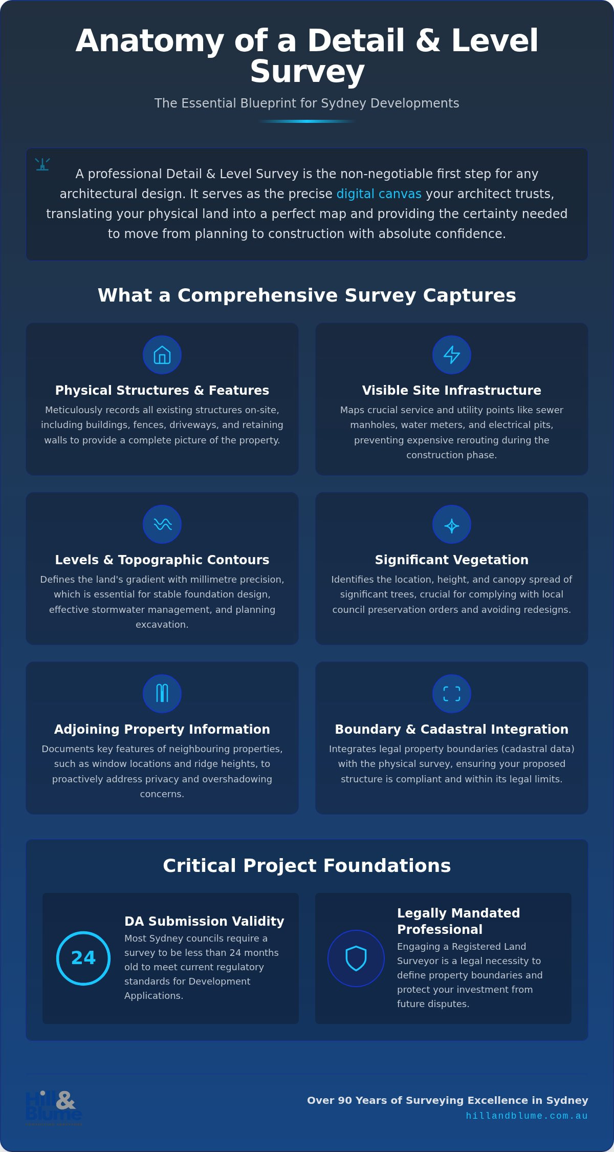
- Understand why a professional detail and level survey sydney is the non-negotiable first step for any architectural design, serving as the precise digital canvas for your project.
- Learn how capturing accurate levels and contours early in the process prevents costly excavation surprises and ensures effective stormwater management.
- Discover why most Sydney councils require a survey less than 24 months old to meet current regulatory standards for Development Applications.
- Recognise the legal necessity of engaging a Registered Land Surveyor to define property boundaries and protect your investment from future disputes.
- Leverage over 90 years of local expertise to navigate the unique site constraints of the Northern Beaches, North Shore, and Inner West with confidence.
Understanding the Detail and Level Survey: Why Precision is Paramount in Sydney
A detail and level survey sydney is the heartbeat of your project’s planning phase. It acts as the foundational spatial dataset, a digital twin that captures every nuance of the terrain before a single pencil hits the drafting paper. In our local industry, you’ll often hear this referred to as a topographic or contour survey. While the names vary, the purpose remains the same: to provide a millimetre-perfect record of the existing environment. In the broader context of Understanding the Detail and Level Survey, these measurements form the essential bridge between untamed land and the architect’s vision.
Sydney’s topography is rarely simple. Whether you’re working with the sandstone outcrops of the Eastern Suburbs or the undulating slopes of the North Shore, a ‘near enough’ approach is a recipe for regulatory friction. In a market where every square metre represents a significant investment, precision isn’t just a technical preference; it’s a financial safeguard. Sydney councils are notoriously strict regarding site levels, and even a minor discrepancy can lead to overshadowing issues or stormwater complications that trigger a costly DA rejection. When you consider the potential for delays, a professional detail and level survey sydney is the most effective insurance policy you can hold.
The First Step in the Development Journey
Architects don’t just prefer a current survey; they require it. Without an accurate baseline, a design might look beautiful on screen but fail the moment it meets the actual site constraints. You need to visualize the reality of your land, from the exact height of existing vegetation to the subtle pitch of a sloping block. This data doesn’t just inform the design; it provides the definitive starting point for a seamless construction set-out once the build begins. It’s about creating a smooth path from the very first concept to the final brick.
Detail vs. Boundary Surveys: Knowing the Difference
It’s a common point of confusion for many property owners. While a boundary survey is strictly focused on the legal limits and title dimensions of your land, a detail survey captures the physical reality of what sits within those lines. It records the fences, the retaining walls, and the ground levels. For a successful DA in Sydney, you’ll almost always need a combination of both. Integrating cadastral data into your topographic map ensures your proposed structure doesn’t just fit the land, but stays firmly within its legal rights. This clarity allows you to plan with a sense of calm confidence, knowing your project is anchored by traditional integrity and modern accuracy.
The Technical Scope: What Every Sydney Detail Survey Must Capture
A comprehensive detail and level survey sydney is an exercise in meticulous observation. It doesn’t merely record where your land ends; it documents exactly how it lives and breathes. Our surveyors identify every physical structure, from the weathered retaining walls to the precise path of your driveway. We map the visible infrastructure that dictates your site’s future, including sewer manholes, water meters, and electrical pits. Missing these details early on often leads to expensive rerouting during the build phase. This level of care reflects our 90-year commitment to providing a seamless, boutique service for every client.
Levels and contours are the quiet heroes of site planning. They define how stormwater travels across your property and dictate the extent of required excavation. In Sydney’s varied terrain, understanding these gradients is essential for a stable foundation. We also meticulously record significant trees, noting their location, height, and canopy spread. Since many local councils have strict preservation orders, knowing exactly where a root zone lies can be the difference between a smooth approval and a total redesign. Ensuring this data is accurate is Why a Registered Surveyor is Non-Negotiable, as it protects the integrity of your entire project.
Adjoining Property Information and Privacy
In our densely populated suburbs, your project doesn’t exist in a vacuum. A high-quality detail and level survey sydney must look beyond your fences to capture neighbouring windows and rooflines. This isn’t just about being a good neighbour; it’s a legal necessity for privacy and overshadowing analysis. Accurate heights of adjoining buildings allow your architect to calculate solar access with precision. It ensures your new build complies with local setbacks and council residential codes, preventing friction before it starts. If you’re unsure what your specific council requires, you can always speak with our team for tailored advice.
Data Formats and Professional Deliverables
The transition from the field to the drafting table should be effortless. We provide CAD-ready digital files that engineers can integrate immediately into their workflows. For non-technical stakeholders, we deliver polished PDF plans that offer a clear, visual narrative of the site. As we move into 2026, the demand for 3D data compatibility is rising. Our deliverables are structured to support modern Building Information Modelling (BIM), ensuring your spatial foundation is ready for the most sophisticated design tools available. It’s a polished, purposeful approach that mirrors the premium quality of the homes you aim to build.
Navigating the DA Process: Sydney Council Requirements
The journey through Sydney’s planning landscape is paved with regulatory expectations. Most local councils, from the heritage-rich streets of the Inner West to the coastal stretches of the Northern Beaches, require a detail and level survey sydney that is less than 12 to 24 months old. This isn’t just a bureaucratic hurdle. It ensures the data reflecting your site is current and captures any recent changes to the land or neighbouring structures. When you’re pursuing a Complying Development Certificate (CDC), this precision becomes even more critical. A CDC relies on strict adherence to pre-defined standards, and even a minor miscalculation in site levels can void your eligibility for this faster approval path.
Our role at Hill & Blume is to provide the spatial clarity that underpins these applications. By integrating our findings with our broader suite of professional services, we ensure your project moves through the planning phase without unnecessary friction. This collaborative approach reflects our 90-year legacy of serving the Sydney community with traditional integrity and a refined, boutique touch. We understand that your project is a significant investment, and our goal is to protect that vision with data that stands up to the most rigorous council scrutiny.
Meeting Local Government Specifications
Councils across the North Shore and Northern Beaches often have unique demands regarding stormwater management and floor levels. In flood-prone areas, referencing the Australian Height Datum (AHD) is a non-negotiable requirement. This universal baseline allows planners to assess flood risks with absolute certainty. As we extend our expertise into the Central Coast and Newcastle regions, we adapt our methods to meet the specific terrain challenges of those areas. Whether it’s navigating steep coastal escarpments or dense urban blocks, our data remains millimetre-perfect and tailored to local government codes.
Avoiding Costly Delays and Resubmissions
An incomplete detail and level survey sydney is often the primary cause of a ‘Request for Further Information’ (RFI) from council. These requests can stall your project for weeks, or even months, costing you both time and momentum. It’s best to align your survey with the very beginning of your architectural design phase to ensure your plans are built on facts from day one. Our involvement doesn’t end at the planning stage. We also verify Work-as-Executed (WAE) data post-construction, ensuring the final build matches the approved plans. This lifecycle approach prevents regulatory headaches and provides the seamless transition from planning to construction you deserve.
The Legal Distinction: Why a Registered Surveyor is Non-Negotiable
The legal landscape of property in New South Wales is precise and unforgiving. When you commission a detail and level survey sydney, you aren’t just buying a map; you’re securing a legal document. Under the Surveying and Spatial Information Act 2002, only a Registered Surveyor in NSW holds the legal authority to define property boundaries. This distinction is vital because any error in boundary placement can lead to catastrophic financial consequences. Unregistered site surveyors might offer lower rates, but they lack the statutory power to certify where your land truly begins and ends. Using an unregistered individual for boundary identification is a risk that can compromise your entire development application.
Choosing a registered professional also provides a critical layer of protection through mandatory professional indemnity insurance. This coverage safeguards your project and your investment against unforeseen spatial discrepancies. It’s a level of security that aligns with our boutique approach. We believe that high-end developments deserve more than just a measurement; they require the certainty that only decades of institutional knowledge can provide. By choosing our specialised surveying services, you’re investing in a partnership grounded in trust and legal rigour.
Professional Integrity and Accuracy
The path to becoming a Registered Surveyor is rigorous. It requires years of university study followed by a strict period of practical training and competency exams administered by the state. This licensing ensures that every professional who signs your plans maintains the highest standards of accuracy. In the eyes of the law, these experts act as impartial officers of the court. If a boundary dispute ever arises, their findings carry the weight of legal evidence. This is precisely why council certifiers and private certifiers mandate a Registered Surveyor’s signature on all critical plans. It’s a seal of quality that reassures every stakeholder involved in the build.
Risk Management for High-Value Developments
In Sydney’s premium property market, the stakes are incredibly high. A minor boundary encroachment can trigger an immediate ‘stop work’ order, halting your construction and draining your budget. We’ve seen how the ‘cowboy’ trap of the cheapest quote often leads to the most expensive mistakes in the long run. Our firm’s 90-year legacy offers more than just technical skill; it provides the peace of mind that comes from traditional integrity. Don’t leave your project’s spatial foundation to chance. Secure your development’s future and reach out to our Registered Surveyors for a bespoke consultation that prioritises your project’s integrity.
Hill & Blume: A 90-Year Legacy of Surveying Excellence in Sydney
Since 1932, our firm has stood as a quiet guardian of Sydney’s property boundaries and development potential. We aren’t just surveyors; we’re stewards of the land’s history and its future. While others focus on high-volume turnover, we prioritize the depth of our relationships and the precision of our craft. We believe a professional detail and level survey sydney is a hand-crafted dataset, not a mere commodity. Our team blends the traditional integrity of our founders with the absolute accuracy of modern Robotic Total Stations and GPS technology. This balance allows us to project a sense of calm confidence that reassures you that you’re engaging with experts who value quality above all else.
The Hill & Blume signature is found in the meticulous nature of our work and our local approachability. It’s the way we translate complex site data into a polished, purposeful narrative for your architectural team. We move at a deliberate pace, ensuring every measurement is considered and every constraint is identified. This effortless service is what distinguishes us from larger, more clinical corporate agencies. We offer a curated experience that feels personal, inclusive, and deeply rooted in the local culture of the regions we’ve served for nearly a century.
Tailored Consulting for Discerning Clients
We’ve become the preferred partner for architects and high-end residential developers who demand more than just a plan. They seek a trusted advisor who understands the nuances of the North Shore, the Inner West, and the coastal stretches of Newcastle and the Central Coast. Our local expertise isn’t just about knowing the terrain; it’s about understanding the specific community values and council expectations that shape each unique project. We act as specialized authorities throughout the life of your development, offering a level of consulting that respects your time and your intelligence.
Setting the Foundation for Your Success
Every iconic Sydney home begins with a single point of truth. Our contour and detail surveys provide that ultimate project security, ensuring your vision is protected by our precision. We invite you to experience a partnership that prioritizes your aspirations and delivers a seamless transition from planning to construction. Your legacy deserves a spatial foundation built on 90 years of professional excellence and traditional integrity. Begin your journey with a professional consultation from Hill & Blume today and secure the precise future of your 2026 development.
Building Your Sydney Legacy on a Foundation of Precision
Your property development is more than a construction project; it’s a vision for a specific lifestyle and a lasting contribution to our local landscape. We’ve explored how a professional detail and level survey sydney acts as the vital digital canvas your architect needs to navigate complex council requirements. By securing millimetre-perfect data early, you eliminate the anxiety of DA rejections and the fear of hidden site constraints. You’re choosing a path of certainty that transforms raw land into a refined architectural reality through meticulous craftsmanship and care.
With a legacy established in 1932, Hill & Blume brings over 90 years of surveying expertise to your project. As Registered Land Surveyors, we provide the legal boundary certainty and NSW council compliance expertise required for high-end developments. We pride ourselves on a boutique service that values the depth of our relationship with you over high-volume turnover. It’s time to move forward with the calm confidence that only a specialised local authority can provide. Secure the precision your Sydney project deserves; contact Hill & Blume today to begin your journey. Your vision is ready to take shape, and we’re here to ensure every level is perfect.
Frequently Asked Questions
What exactly is included in a detail and level survey?
A comprehensive detail and level survey captures all physical features on your land and along the immediate boundaries. This includes the footprint of existing buildings, fences, retaining walls, and paved areas. We also map visible services like sewer manholes and water meters, alongside significant trees including their canopy spread. These elements are overlaid with precise ground levels and contours, providing the essential spatial foundation your architect needs to design with absolute confidence.
Is a detail survey the same as a contour survey?
Yes, these terms are frequently used interchangeably across the Sydney property market. While a contour survey specifically focuses on the undulating levels and slope of the land, a detail survey is more comprehensive. It captures the contours alongside all physical structures and site features. In most architectural and council contexts, you’ll require the full scope of a detail and level survey to ensure every constraint is accounted for during the planning phase.
How much does a detail and level survey cost in Sydney?
The cost of a detail and level survey sydney varies based on the size, slope, and complexity of your site. For standard residential blocks, industry data suggests costs typically range between A$1,500 and A$4,500. Larger sites with dense vegetation or difficult access often sit at the higher end of this scale. We recommend a bespoke consultation to understand the specific requirements of your land, ensuring you receive a tailored solution that reflects the quality of your project.
How long does it take to complete a detail survey and receive the plans?
Timelines generally depend on the complexity of the terrain and our current project schedule. Typically, the on-site fieldwork is completed within a single day. Following this, our team meticulously processes the data and drafts your plans, a process that usually takes between one and two weeks. We prioritize depth of relationship and quality over high-volume turnover, ensuring your final deliverables are polished, purposeful, and ready for immediate architectural use.
Why does my Sydney council require a survey for a simple renovation?
Even modest renovations can impact the delicate balance of a local neighbourhood. Sydney councils require current surveys to verify that your proposed changes comply with strict regulations regarding setbacks, privacy, and overshadowing. This data allows planners to assess how your project interacts with neighbouring windows and rooflines. Providing a precise spatial baseline ensures your application moves through the DA process smoothly, avoiding the friction of requests for further information or costly design revisions.
Can I use the survey provided by the real estate agent when I bought the house?
It is rarely advisable to rely on an old survey for a new development application. Most Sydney councils mandate that a survey must be less than 12 to 24 months old to ensure the data is accurate and current. Site conditions, neighbouring structures, and even land levels can shift over time. Using an outdated plan risks a DA rejection or significant design errors. A fresh survey provides the certainty and legal integrity your 2026 project deserves.
Do I need a Registered Surveyor for a detail and level survey in NSW?
Yes, engaging a Registered Land Surveyor is essential, especially when your project involves defining property boundaries. Under the Surveying and Spatial Information Act 2002, only a registered professional has the legal authority to certify boundary positions. This ensures your project is protected by professional indemnity insurance and carries the weight of legal evidence. Choosing a detail and level survey sydney from a registered expert provides a seal of quality that safeguards your high-value investment.
What file formats will my architect receive from the surveyor?
Your design team will receive high-quality, CAD-ready digital files, typically in DWG format, which integrate seamlessly into modern architectural software. We also provide polished PDF plans for easy viewing by all stakeholders. As we move towards mandatory digital submissions in 2026, we ensure our data is compatible with LandXML and BIM workflows. This effortless transition from field data to digital map reflects our commitment to a sophisticated and professional service for every client.
Disclaimer
The information provided in articles published on this website is for general informational purposes only. While we make every effort to ensure the accuracy, completeness, and timeliness of the content, the material is based on our understanding of the industry at the time of writing and may not reflect the most current developments, regulations, or standards. All opinions expressed in our articles are those of the respective authors and do not necessarily represent the official position of the website or its affiliates. The content should not be considered professional, legal or technical advice, and should not be relied upon as a substitute for consultation with qualified professionals