
What if the most vital safeguard for your property investment isn’t the depth of the concrete, but a series of invisible legal lines? In the sophisticated landscape of NSW development, the role of registered surveyor in construction is far more than a simple measurement exercise; it’s the foundation of your project’s legal and structural integrity. You likely feel the weight of responsibility that comes with a new build, from the initial DA submission to the final handover. The fear of a boundary dispute with a neighbour or a structural misalignment is real, and it can quickly turn a dream project into a stressful ordeal.
We understand that you value quality and precision above all else. This article explores how a registered surveyor protects your interests through every phase of development, from pinpointing building footprints to securing your Occupation Certificate. You’ll discover the essential steps to ensure total compliance with NSW planning laws, providing you with the calm confidence that your project is grounded in absolute accuracy and professional care. We’ll guide you through the transition from design to completion, ensuring your vision is built on a foundation of certainty.
Key Takeaways
- Understand why only a professional registered under the Surveyors and Spatial Information Act 2002 possesses the legal authority to define and certify your property boundaries.
- Discover how detail and level surveys create a precise digital foundation, mapping every topographic nuance to prevent costly structural misalignments.
- Learn how the role of registered surveyor in construction ensures your architectural vision is perfectly translated to the physical site through accurate peg-out surveys.
- Explore the vital importance of Work-as-Executed (WAE) reports in securing your Occupation Certificate and verifying that all infrastructure meets NSW standards.
- Realise the value of a partnership that combines nearly a century of local Sydney expertise with a boutique approach focused on quality and legal certainty.
The Legal Mandate: Why a Registered Surveyor is Essential in NSW
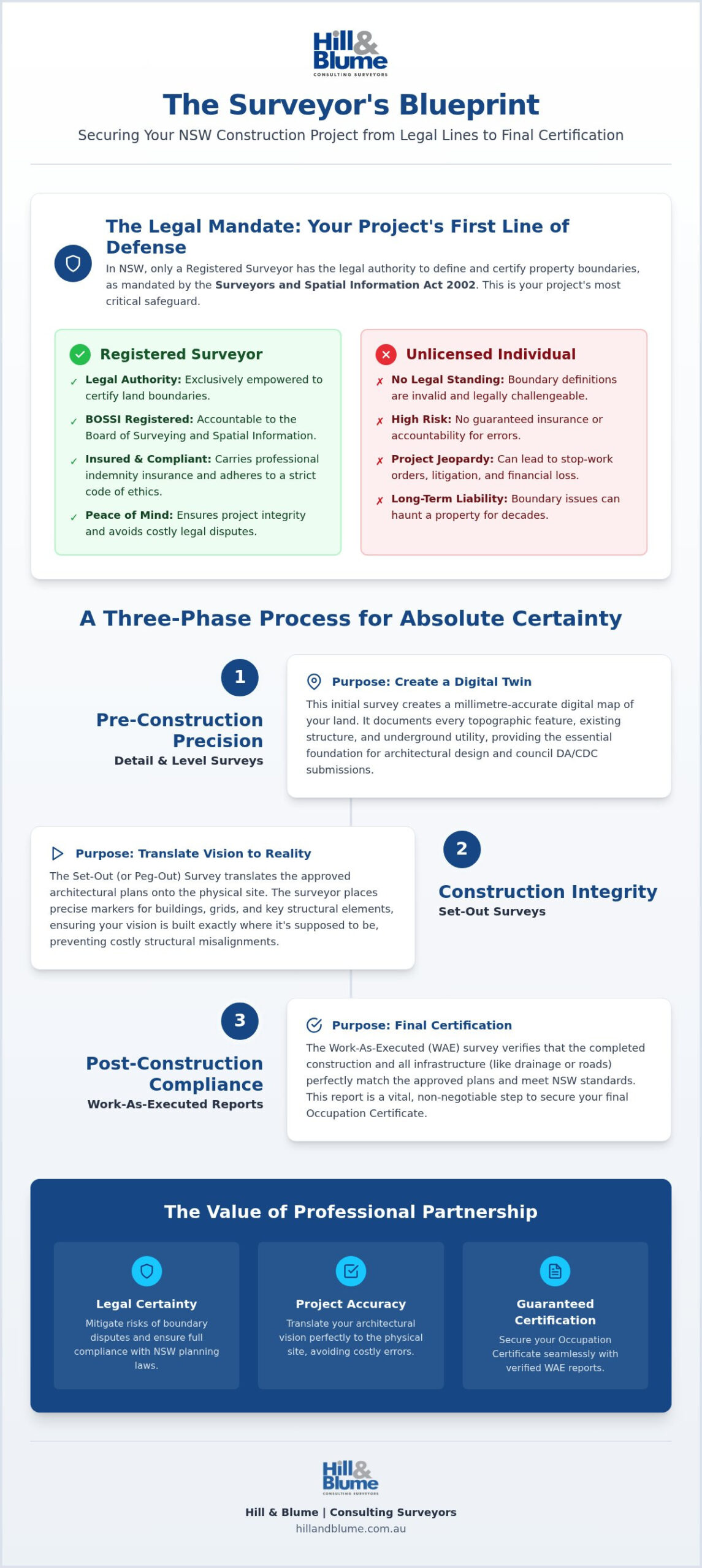
Your property is more than just a physical site; it’s a collection of legal rights defined by invisible lines. In New South Wales, the Surveyors and Spatial Information Act 2002 strictly governs who can define these boundaries. Only a Registered Surveyor possesses the exclusive legal authority to determine and certify land boundaries. This isn’t a mere administrative preference. It’s a statutory requirement designed to protect the integrity of the state’s land title system. When you engage a professional for your build, the role of registered surveyor in construction is to act as the legal guardian of your property’s footprint, ensuring every millimetre of your project sits exactly where it should.
Registration with the Board of Surveying and Spatial Information (BOSSI) is the gold standard for construction professional indemnity. This registration provides a layer of security that unlicensed individuals simply cannot offer. It guarantees that your surveyor carries the necessary insurance and adheres to a strict code of ethics. Choosing a registered professional means you aren’t just hiring a person with a tripod; you’re partnering with a specialist whose work is backed by the full weight of NSW law. This level of accountability is what creates the calm confidence you need when investing in a high-end development.
Registered vs. Unlicensed: Understanding the Difference
The path to becoming a Registered Surveyor in NSW is demanding. It requires years of university study followed by a rigorous period of practical training and professional competency examinations. This process ensures that a registered professional understands the complex interplay between historical land titles and modern GPS technology. Only a Registered Surveyor can provide an Identification Survey Report, which is often a non-negotiable requirement for banks and legal practitioners during property transactions. Their signature is a seal of quality that confirms the structure’s relationship to the boundary is accurate and lawful.
The Consequences of Non-Compliance
The risks of bypassing a registered professional are significant. If a boundary is incorrectly determined by an unlicensed individual, the consequences can be immediate and devastating. You may face stop-work orders from the local council or, worse, expensive litigation from a neighbour. A cadastral survey serves as the legal basis for all property ownership; it’s the definitive map of rights that governs your land. Failing to secure this legal foundation can lead to long-term liability that haunts a property for decades. By prioritising the role of registered surveyor in construction, you eliminate these anxieties and ensure a seamless path from the first shovel to the final occupation certificate.
Pre-Construction Precision: Detail and Level Surveys
Before the first shovel touches the earth, your project exists as a vision in a digital space. To ensure this vision translates perfectly to your Sydney or Newcastle site, you must establish what professionals call a ‘digital twin’. This is a comprehensive, millimetre-accurate representation of your land as it exists today. The role of registered surveyor in construction begins here, long before any physical structure appears. By mapping every topographic feature, existing structure, and underground utility, we provide the clarity required to move forward with absolute confidence.
These contour and detail surveys are the essential foundation for any modern development. They don’t just record what’s visible; they document the hidden constraints that could derail a project later. Linking this precise site data to your Council’s Development Application (DA) or Complying Development Certificate (CDC) requirements is vital. It ensures that your submission isn’t just a request for permission, but a demonstration of total site awareness. Understanding the role of registered surveyor in construction during this early planning phase is often the difference between a seamless approval and a costly delay.
The Foundation of Architectural Design
Architects require more than just a general idea of your land’s shape. They need precise site constraints to craft a design that fits perfectly within the legal and physical landscape. A registered surveyor identifies essential easements and encumbrances that dictate your buildable area, preventing designs that might later be rejected. We also establish North-point accuracy with meticulous care. This isn’t just for orientation; it’s a critical requirement for solar access compliance, ensuring your new home or development meets the sophisticated environmental standards expected in Australia’s premium property market.
Topographic Analysis for Drainage and Excavation
Unforeseen excavation costs are the enemy of any construction budget. By providing detailed slope data, we allow your engineers to calculate exactly how much earth needs to be moved and where retaining walls are truly necessary. We establish permanent site benchmarks that serve as the single source of truth for height measurements throughout the entire build. This level of foresight ensures that your drainage plans meet local Sydney catchment standards from the outset. If you’re ready to ground your project in this level of detail, reach out to our specialist team to discuss your site’s unique requirements.
The Construction Phase: Set-outs and Site Integrity
Once the design is finalised and approvals are secured, the project moves from the studio to the soil. This is where the theoretical meets the tangible. The role of registered surveyor in construction during this phase is to ensure that what was approved on paper is exactly what is built on the ground. It’s a delicate process of translation, turning two-dimensional architectural drawings into a three-dimensional reality with absolute precision. Without this bridge, even the most inspired designs risk falling out of alignment with the physical site.
Accuracy at this stage is non-negotiable. Whether you are building a boutique residence or a complex multi-storey development, maintaining construction set-out integrity is the only way to safeguard your investment. We don’t just mark lines; we establish a framework of certainty that allows builders to work with confidence. Knowing that footings and walls are perfectly aligned with both the design and the legal boundaries of the site prevents the frantic corrections that often plague less-considered builds.
The Set-out Process: From Plans to Pegs
The transition from digital coordinates to physical markers follows a disciplined sequence to ensure nothing is left to chance:
- Coordinate Calculation: We begin by extracting precise data from the approved architectural and structural plans, ensuring every corner and load-bearing element is accounted for.
- Physical Marking: Our team visits the site to place high-visibility pegs, nails, or recovery marks. These serve as the primary reference points for your excavation and formwork teams.
- Certification: Upon completion, we issue a Set-out Certificate. This document provides your builder and private certifier with the formal assurance that the project is positioned correctly.
Preventing Costly Encroachment Disputes
Boundary disputes are often the most stressful and expensive part of any construction project. A registered surveyor acts as an impartial arbiter of truth, providing a neutral, evidence-based determination of where your rights end and your neighbour’s begin. Guessing these lines is a gamble that rarely pays off, as even a minor oversight can lead to years of legal friction. It’s a sobering reality that a 10mm error in set-out can result in six-figure rectification costs. By prioritising the role of registered surveyor in construction, you replace that risk with the peace of mind that comes from professional craftsmanship and nearly a century of local expertise.
Post-Construction Compliance: WAE and Final Certification
As the scaffolding descends and the physical labour nears completion, your project enters its most critical administrative phase. You’ve seen the vision take shape, but before you can legally occupy or sell the property, you must prove that the as-built reality aligns perfectly with the as-approved plans. This is where the role of registered surveyor in construction shifts from guidance to verification. It’s a phase defined by meticulous scrutiny, ensuring every pipe, footing, and wall sits within its legal and environmental boundaries.
This final stage isn’t just about ticking boxes for the council; it’s about protecting your long-term investment. By providing a definitive record of the completed works, we ensure that your property is free from the legal ambiguities that can complicate future sales or renovations. It’s the final layer of professional care that transforms a construction site into a secure, compliant, and market-ready asset.
The WAE Survey: Proving Compliance
Sydney and Newcastle councils are particularly vigilant regarding infrastructure that impacts the broader community. A Work-as-Executed (WAE) survey is a mandatory requirement for On-site Stormwater Detention (OSD) systems and other public assets. We map the exact position, levels, and storage volumes of these systems once they’re installed, providing the precise data your Private Certifier needs to issue the final sign-off. It’s about ensuring the long-term safety and efficiency of your site’s drainage, preventing unforeseen environmental issues that could lead to costly council orders down the track.
Final Identification and Title Registration
Before an Occupation Certificate (OC) can be granted, you’ll require a Final Identification Survey. This document acts as your building’s legal clean bill of health. It certifies the relationship between the finished structure and the property boundaries, confirming that the role of registered surveyor in construction has successfully mitigated any risk of encroachment. For multi-unit developments, this stage also involves the preparation of strata plans or subdivision plans. These documents serve as the legal blueprints for individual ownership, allowing you to register titles and officially bring your project to the luxury market. If you’re approaching the final stages of your build and need to secure your certification, contact our senior surveyors to ensure a seamless transition to occupation.
Choosing Your Surveying Partner: The Hill & Blume Difference
Selecting a partner for your build is a decision that resonates through every brick and beam of your future property. At Hill & Blume, we view the role of registered surveyor in construction as a collaborative craft, not just a technical service. Since our founding in 1932, we’ve helped shape the unique landscape of Sydney, Newcastle, and the Central Coast, bringing a sense of calm confidence to projects that demand excellence. We understand that your development is a reflection of your aspirations, and we treat every site with the same care and discernment you do, ensuring a seamless journey from the first boundary mark to the final title registration.
90 Years of Local Sydney Expertise
Our 90-year history isn’t just a point of pride; it’s a vast archive of local knowledge that directly benefits your project today. Our historical records include original survey plans and field notes that pre-date modern digital systems, providing a unique advantage in boundary identification. This historical depth allows us to resolve complex title issues that might stall a less experienced firm. Over nearly a century, we’ve fostered deep, respectful relationships with local Sydney councils and planning authorities. By choosing our boutique agency, you ensure your vision is never treated as just another file number. Instead, you receive direct access to senior Registered Surveyors who prioritize the specific needs of your site over high-volume turnover.
Secure Your Project’s Future
We believe that true precision comes from a blend of traditional integrity and 2026-standard surveying technology. Our team utilizes the latest spatial tools to deliver the pinpoint accuracy your architect and engineer require, while maintaining the steady, personal touch of a specialized local authority. This partnership-oriented narrative is designed for discerning developers and homeowners who value quality over quantity. We invite you to experience a service that prioritizes the human element of real estate, rooted deeply in our shared regional culture and a passion for the Australian lifestyle. Whether you’re crafting a sophisticated urban residence or a coastal retreat, our focus remains on providing legal certainty and structural peace of mind. To ensure your project is built on a foundation of absolute accuracy, reach out to our team today to discuss your professional surveying requirements.
Ground Your Vision in Absolute Certainty
Your construction project is an investment in a specific lifestyle and a lasting legacy. We’ve explored how the role of registered surveyor in construction acts as the vital thread connecting your architectural vision to legal and structural reality. From the initial topographic mapping that informs your design to the final Work-as-Executed reports that secure your Occupation Certificate, precision is the only path to peace of mind. You deserve a partner who understands that a minor discrepancy can be the difference between a seamless handover and a costly legal dispute.
Hill & Blume brings 90+ years of Sydney surveying expertise to your site, ensuring every boundary is defined with traditional integrity and modern technology. As specialists fully registered with the NSW Board of Surveying and Spatial Information (BOSSI), we provide the discerning care your development requires. Whether you’re navigating complex set-outs or final strata plans, our boutique approach ensures your project remains our priority. Secure your project’s precision with Hill & Blume’s registered surveyors and move forward with the confidence that your build is grounded in excellence. We look forward to helping you bring your next vision to life.
Frequently Asked Questions
What is the difference between a land surveyor and a registered surveyor in NSW?
In NSW, the distinction is a legal one; a Registered Surveyor is a professional who has completed rigorous training and examinations to be licensed by the Board of Surveying and Spatial Information (BOSSI). While many land surveyors are skilled technicians, only a Registered Surveyor possesses the exclusive legal authority to certify property boundaries and sign off on cadastral plans. This registration ensures they carry professional indemnity insurance and adhere to strict ethical standards mandated by state law.
At what stage of construction do I need to hire a registered surveyor?
You should engage a professional as early as the planning and design phase to secure a Detail and Level Survey. This initial data allows your architect to design with confidence, knowing the exact site constraints. The role of registered surveyor in construction continues during the build for set-outs and concludes with final certifications. Early involvement prevents the structural misalignments and legal delays that often arise from late-stage site assessments.
Can a builder perform a construction set-out without a surveyor?
While a builder may have the equipment to mark out structures, they lack the legal authority to certify that those marks align with your property boundaries. Most private certifiers and local councils in Sydney require a Set-out Certificate issued by a Registered Surveyor before construction can proceed. Relying on a builder for this task carries significant risk; even a minor error can lead to encroachment disputes that are incredibly expensive to rectify.
How much does a registered surveyor cost for a standard construction project in Sydney?
The investment for surveying services in Sydney varies depending on the complexity of your site, the size of the development, and specific council requirements. Factors such as heavy vegetation, steep terrain, or complex title histories can influence the scope of work required. Instead of looking for a flat rate, it’s best to request a tailored quote that reflects the unique nuances of your property and the level of precision your project demands.
What is a Work-as-Executed (WAE) survey and is it mandatory?
A Work-as-Executed (WAE) survey is a detailed plan that records the final “as-built” position and levels of critical infrastructure, particularly stormwater detention systems. It is mandatory for most developments in NSW to satisfy council requirements and secure an Occupation Certificate. This survey proves that the constructed drainage matches the engineering plans, ensuring the site manages water effectively and doesn’t impact neighbouring properties or public assets.
How long does a construction set-out survey usually take to complete?
A standard construction set-out survey typically requires a few hours on site for the physical marking, though the entire process involves significant preparation and post-survey certification. Our team spends time beforehand calculating coordinates from your architectural plans to ensure absolute precision. Once the site work is finished, we usually issue the formal Set-out Certificate within a few business days, allowing your builders to commence work without unnecessary delays.
Will a registered surveyor help resolve a boundary dispute with my neighbour?
A Registered Surveyor acts as an impartial, expert arbiter in boundary disputes by providing a definitive, evidence-based determination of your land’s legal limits. By conducting an Identification Survey, we can verify the position of fences or structures relative to the title boundary. This professional report often resolves tensions by replacing guesswork with legal certainty, providing a clear path forward that respects the rights of both property owners.
What documents do I need to provide to a surveyor before they start work?
To begin work, we typically require your final architectural and structural plans in a digital format, such as DWG or PDF. It’s also helpful to provide copies of your Development Application (DA) or Complying Development Certificate (CDC) conditions, as these often specify particular surveying requirements. Having these documents ready allows us to understand the role of registered surveyor in construction as it applies specifically to your project’s unique compliance needs.
Disclaimer
The information provided in articles published on this website is for general informational purposes only. While we make every effort to ensure the accuracy, completeness, and timeliness of the content, the material is based on our understanding of the industry at the time of writing and may not reflect the most current developments, regulations, or standards. All opinions expressed in our articles are those of the respective authors and do not necessarily represent the official position of the website or its affiliates. The content should not be considered professional, legal or technical advice, and should not be relied upon as a substitute for consultation with qualified professionals