
Could a few centimetres of pipe deviation really stand between you and your project’s final Occupation Certificate? It is a stressful reality for many developers in New South Wales who find their progress halted by minor discrepancies between design plans and the finished work. You’ve poured your expertise and resources into every detail of construction, so it feels particularly jarring when complex council requirements or digital file formats create a bottleneck at the very end.
We understand that you value precision and want a result that reflects the high quality of your build. This guide is designed to ensure your project’s seamless transition from construction to certification with a professional WAE survey for stormwater assets. We’ll walk you through the essential legal standards of the Environmental Planning and Assessment Act 1979, explain the intricacies of ADAC XML digital files, and show you how accurate mapping provides the confidence you need for a fast, compliant council submission. By bridging the gap between design and the as-built reality, you can secure your final sign-off with absolute peace of mind.
Key Takeaways
- Understand why a WAE survey for stormwater assets is the essential final step to securing your Occupation Certificate and satisfying NSW legislation.
- Discover how precise measurements of invert levels and pipe locations protect your project from future drainage issues and costly remedial works.
- Learn why the statutory authority of a Registered Surveyor is vital for verifying infrastructure accuracy and managing your professional risk.
- Follow the refined process of translating physical on-site assets into the compliant digital records required for a smooth council submission.
- Gain the peace of mind that comes from partnering with local experts who understand the unique nuances of your specific council’s requirements.
What is a WAE Survey for Stormwater Assets?
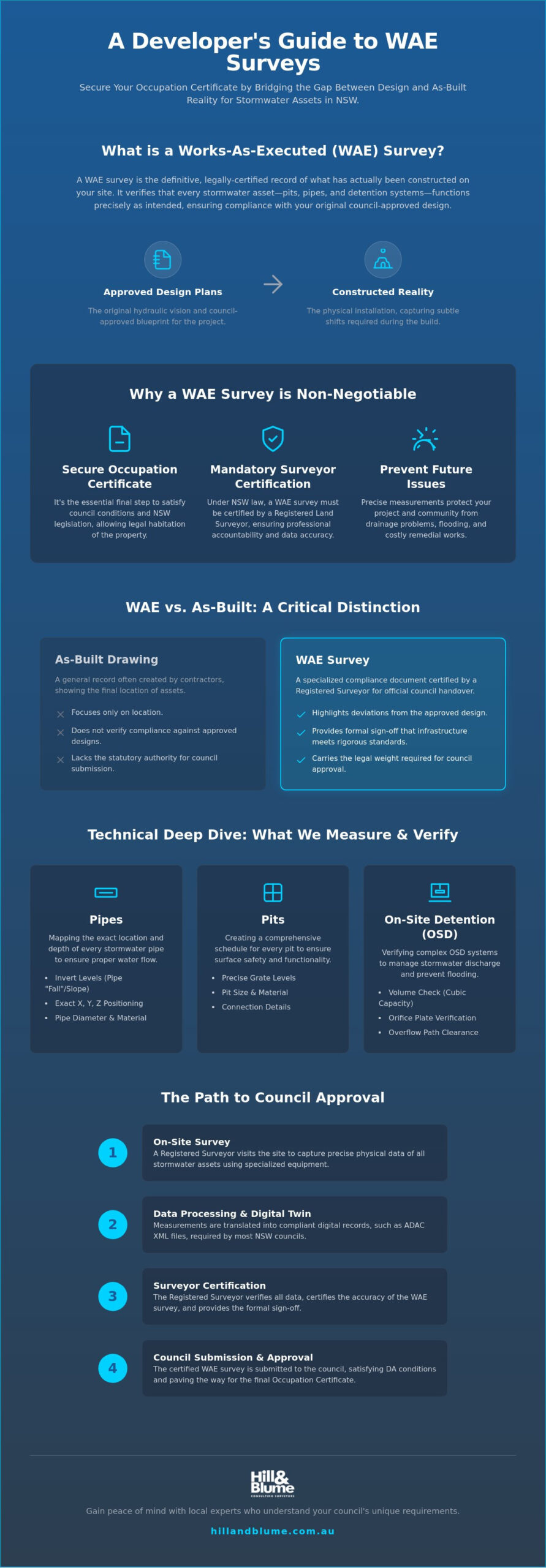
A WAE survey for stormwater assets is the definitive record of what has actually been constructed on your site. While your original hydraulic plans represent the ideal vision, the physical reality of the earth often requires subtle shifts during the build. This survey captures those nuances, verifying that every pit, pipe, and detention system functions exactly as intended. It is more than a technicality; it is the bridge between a completed construction site and a legally habitable property that honors your original design intent.
In New South Wales, the legal weight of this document is significant. Under state legislation, a WAE survey must be certified by a Registered Land Surveyor. This ensures that the data provided to your local council is accurate and carries professional accountability. Engaging a Registered Land Surveyor for a WAE survey for stormwater assets ensures that your project remains compliant and avoids the stress of rejected paperwork. Our team at Hill & Blume offers a range of professional surveying services to guide you through this final, critical stage of your development journey.
The core of this work involves measuring the intricate details of your drainage system with refined precision. We look at invert levels, which determine the fall of the water, and the exact positioning of underground pipes. Effective Stormwater management is vital for protecting the integrity of your land and the surrounding community. By documenting these assets precisely, you ensure that runoff is managed safely and that your project contributes positively to the local environment through thoughtful craftsmanship.
WAE vs. As-Built: Is there a difference?
You might hear the term ‘as-built’ used frequently on site, but in the context of NSW regulation, ‘WAE’ is the specific terminology you need to master. While an as-built drawing might simply show where things are located, a WAE survey specifically highlights deviations from the council-approved hydraulic design. It focuses on compliance, providing a formal sign-off that the infrastructure meets the rigorous standards set during the planning phase. This specialized focus is what allows for a seamless handover to local authorities.
The Role of Stormwater Assets in Property Certification
Your stormwater system is a silent guardian of public safety. Councils require these surveys to verify that runoff won’t impact neighbouring properties or public roads. This data also allows local authorities to update their GIS and infrastructure maps, ensuring they have a clear picture of the assets they may eventually inherit. Completing this survey is the final step in closing the loop on your Development Application conditions, allowing you to move forward with the confidence that your project’s legacy is secure.
Technical Requirements: Pits, Pipes, and OSD Systems
Precision is the hallmark of a successful development. When we step onto a site to conduct a WAE survey for stormwater assets, we aren’t just ticking boxes; we are creating a digital twin of your property’s underground veins. This involves mapping the exact location and depth of every stormwater pipe. It’s a delicate task that requires specialized equipment to see through the soil and verify that the physical installation mirrors the engineering design.
The “fall” of a pipe, or its invert level, is perhaps the most critical technical detail we capture. Gravity is the engine of drainage. Even a minor deviation in the slope can lead to stagnant water or localized flooding. We also document a comprehensive pit schedule for every asset on the site. This includes the size and material of the pits, along with the precise grate levels. These details ensure that the finished surface is safe, functional, and aesthetically aligned with your landscape.
The Critical Importance of OSD Verification
On-site Detention (OSD) systems are often the most complex part of a stormwater network. We perform rigorous volume checks to ensure the detention tank holds the exact cubic capacity required by your design. This isn’t just about the tank itself; we verify the orifice plate as well. This small, precisely drilled metal plate controls the discharge rate into the council’s network. If the hole is too large, you risk overwhelming public infrastructure; if it’s too small, your own site might flood. We also confirm that high-water marks and overflow paths are clear, providing a safety net for extreme weather events.
ADAC XML and Digital Data Standards
Modern compliance has moved beyond paper plans. Most NSW councils now require data in the ADAC (Asset Design As Constructed) XML format. This digital standard allows councils to ingest your project data directly into their management systems without manual entry. Data integrity is paramount here. A single formatting error can lead to a frustrating council rejection. By providing a clean, compliant XML file, we help streamline your approval process. If you have questions about how these standards apply to your specific site, we invite you to reach out for a conversation about your project’s unique needs.
A WAE survey for stormwater assets is about more than just numbers on a page. It’s about ensuring the long-term health of your property. When every pipe has the correct fall and every OSD tank is verified to its design capacity, you aren’t just meeting a requirement. You’re protecting your project’s legacy and ensuring it remains a valuable part of the local fabric for years to come.
Why a Registered Surveyor is Essential for WAE Certification
The signature of a Registered Surveyor on your final plans is more than a formality. It is a legal guarantee that the infrastructure on your site exists exactly where the documents say it does. In New South Wales, this statutory authority is a requirement. Only a Registered Land Surveyor has the legal mandate to certify the position of infrastructure relative to property boundaries and design levels. This ensures that your WAE survey for stormwater assets carries the weight of law, providing the ultimate layer of protection for your development.
When you engage a professional for this task, you are also transferring professional liability. The surveyor takes on the significant risk of verifying that every pipe, pit, and detention system is accurate to the millimetre. To achieve this level of precision, we utilize high-precision GPS and total station technology. These tools allow us to capture data with a level of detail that manual measurements simply cannot match. It is this commitment to accuracy that allows us to offer a range of specialized surveying services tailored to the unique demands of the NSW landscape.
Trust is a currency that is earned over decades, not days. Long-standing firms like Hill & Blume have spent years building credibility with local authorities across Sydney and the Central Coast. When a council officer sees a certified WAE from a trusted name, it often leads to a smoother review process. They know the data is reliable, the formatting is correct, and the professional standards have been upheld without compromise.
The Risks of Non-Compliant Surveys
Choosing a non-registered provider or settling for poor documentation can lead to a cascade of project failures. The most immediate risk is a delay in your Occupation Certificate, which can stall final settlements and create significant financial pressure. If infrastructure is incorrectly reported and later found to be non-compliant, the remedial costs can be astronomical. Digging up finished concrete to relocate a pipe is a nightmare no developer wants to face. Valid WAE reports are also vital for your long-term insurance and property liability, ensuring you are protected against future claims related to drainage or runoff.
Hill & Blume’s Boutique Approach to Compliance
With 90 years of experience, our firm brings deep historical context to modern infrastructure challenges. We don’t just work for you; we work alongside your hydraulic engineers and builders in a true partnership model. This collaborative spirit ensures that potential issues are identified and resolved long before they reach the council’s desk. Whether we are conducting a complex boundary survey or a technical WAE, our precision is our promise. We believe in providing a seamless, boutique experience that values the quality of your project above all else.
The WAE Survey Process: From Site Visit to Council Approval
The transition from a busy construction site to a certified property is a journey of precision. A WAE survey for stormwater assets serves as the final, authoritative record that bridges the gap between your hydraulic engineer’s vision and the physical reality of the build. This process is deliberate and detailed, ensuring that every element of your drainage system is documented with the care your project deserves. By following a structured path from the initial consultation to the final council submission, we ensure your project remains on track for its final sign-off.
Step 1: Preparation and Plan Review
Before our surveyors arrive on-site, we begin with a thorough review of your “Approved for Construction” drawings. We study the hydraulic design and the specific conditions of your Development Application to identify exactly what the council will scrutinize. This preparation allows us to focus on critical compliance points, such as detention volumes or sensitive discharge locations. We often recommend scheduling the site visit while assets are still visible; capturing data before backfilling provides the most transparent record of your work’s quality.
Step 2: Field Measurement Techniques
Our fieldwork utilizes advanced robotic total stations to capture the precise coordinates of every pit and pipe. We don’t just rely on surface observations. Our team performs physical inspections to verify pipe diameters and material types, ensuring they match the specified design. We also measure the “as-built” levels of the surrounding land. This confirms that overland flow paths are maintained, protecting your property from unexpected runoff issues during heavy rain. It is this level of detail that defines a truly professional WAE survey for stormwater assets.
Step 3: Council Submission and Coordination
Once the data is captured, we move into the drafting phase. We create “red-line” markups that clearly highlight any variations from the original design. These variations are common; what matters is that they are accurately documented and certified. We coordinate closely with your project’s Certifier to ensure the final package meets every regulatory hurdle. Whether you are applying for a Subdivision Certificate or a final Occupation Certificate, this documentation is your key to a successful sign-off.
The final step involves generating the necessary ADAC XML files and signing the statutory certifications. This digital handover is the seal of quality that allows your project to move into its next phase with absolute confidence. If you are ready to finalize your project’s compliance and secure your legacy, we invite you to book your site visit with our expert team today.
Securing Your Project’s Legacy with Hill & Blume
A final WAE survey for stormwater assets is the moment your physical labor transforms into a certified asset. It represents the successful conclusion of a complex journey, turning intricate engineering into a compliant record that stands the test of time. We believe that precision is the highest form of respect for your work. By providing more than just measurements, we offer the calm confidence that your project meets every regulatory standard, allowing you to focus on the next chapter of your development with absolute peace of mind.
Our expertise is deeply rooted in the local landscapes of Sydney, Newcastle, and the Central Coast. Each council maintains its own nuances and specific expectations for infrastructure handover. We navigate these local requirements with a refined touch, ensuring that your submission is polished and purposeful. This specialized knowledge is the result of over nine decades of dedicated service to the New South Wales development community. It’s a legacy of trust that ensures your project is anchored by traditional integrity and modern technical excellence.
This final verification is the natural, sophisticated conclusion to the surveying journey. It often follows the critical work of the construction set-out, where the first marks were made in the soil. By maintaining a consistent thread of accuracy from the first stake to the final WAE, we ensure a seamless integration of data. This holistic approach minimizes the risk of surprises during the completion phase, providing a curated experience that distinguishes your build from the rest.
Our Commitment to Sydney’s Development Community
At Hill & Blume, we view every client as a partner in the local fabric. You aren’t just a project number in a high-volume system; you are a discerning developer who values quality over quantity. Our boutique model allows us to provide expert guidance, helping you understand the “why” behind the WAE survey for stormwater assets and the broader compliance landscape. We invite you to explore our full suite of Hill & Blume Services to see how our handcrafted approach can support your project from inception to sign-off.
Next Steps for Your WAE Survey
Timing is a vital element of a stress-free certification. Ideally, you should contact your surveyor two to three weeks before your construction reaches completion. This lead time allows us to review your hydraulic plans and DA conditions thoroughly before we arrive on-site. Having your “Approved for Construction” documents ready ensures a deliberate and efficient process from the very first conversation.
We believe in transparency and certainty for your project budget. Our fixed-fee approach ensures there are no hidden costs, allowing you to plan your final settlement with precision. When you are ready to secure your final sign-off, we are here to provide the expert mapping and certified confidence your project deserves. Let’s work together to ensure your stormwater assets are documented with the care and craftsmanship they represent.
Finalizing Your Certification with Confidence
Securing your Occupation Certificate is the final milestone in a journey of craftsmanship and dedication. By ensuring your WAE survey for stormwater assets is handled with precision, you bridge the gap between physical construction and regulatory compliance. You’ve seen how accurate mapping of OSD systems and the statutory authority of a Registered Surveyor protect your project from delays and future liability. Moving from paper plans to the modern ADAC XML digital standard is a sophisticated step that requires both technical skill and local council expertise.
Our team brings over 90 years of Sydney surveying expertise to every partnership. As Registered Land Surveyors, we specialize in navigating complex council requirements and providing the specialized digital files necessary for a smooth sign-off. We invite you to secure your project’s compliance with a professional WAE survey from Hill & Blume. Let’s work together to ensure your development’s infrastructure is documented with the same care you put into its construction. Your project’s legacy is in safe hands.
Frequently Asked Questions
What is a WAE survey for stormwater assets?
A WAE survey for stormwater assets is a precise, certified document that records the exact location, depth, and dimensions of drainage infrastructure after construction is complete. It compares the finished work against the original council-approved hydraulic plans to verify that the system functions as intended. This process ensures that your property’s runoff is managed safely and that all assets are accurately mapped for future maintenance and legal compliance.
Is a WAE survey mandatory for all Sydney developments?
Yes, a certified survey is almost always a mandatory requirement for any Sydney development that includes new or modified stormwater infrastructure. Your local council will specify this as a condition of your Development Application (DA). Without this formal verification, a private certifier cannot legally issue an Occupation Certificate, which is the final document required before you can occupy or sell the property.
How much does a WAE survey cost in NSW?
The cost of a survey depends on the unique complexity of your project, including the number of pits, the length of the pipe network, and the size of any detention systems. While there are no centrally mandated government fees for this service, we recommend seeking a fixed-fee quote to provide certainty for your development budget. Factors such as site accessibility and the requirement for digital ADAC XML files will also influence the final investment.
Who can provide a certified Work-as-Executed survey?
In New South Wales, only a Registered Land Surveyor has the statutory authority to certify a Work-as-Executed survey. This professional registration ensures the surveyor carries the necessary liability insurance and technical expertise to verify infrastructure positions relative to property boundaries. Engaging a registered professional provides the legal security that councils require for infrastructure handover and final property certification.
What happens if my stormwater assets differ from the original design?
Minor variations are common during construction and are documented through red-line markups on your final plans. If the deviations are significant and impact the system’s performance, you may need to consult your hydraulic engineer for a design amendment or perform remedial works. Our role is to capture these differences accurately so that any issues can be identified and resolved before the final council submission.
How long does it take to complete a WAE survey and report?
Most surveys and the resulting reports are completed within one to two weeks following the site visit. This timeframe allows for meticulous field measurements and the technical drafting required to compare the as-built data with your original designs. Larger commercial projects or those requiring complex digital data formats may take slightly longer to ensure every detail meets the council’s rigorous standards.
What is an ADAC XML file and why do I need one?
ADAC stands for Asset Design As Constructed and is the digital data standard used by many NSW councils to manage their infrastructure networks. You need this XML file because it allows the council to import your project’s stormwater data directly into their geographical information systems. Providing this correctly formatted digital file is often a non-negotiable requirement for securing your final project sign-off in many local government areas.
Can a WAE survey be done after the pipes are covered?
While it is possible to conduct a WAE survey for stormwater assets after backfilling, it is significantly more efficient to measure assets while they are still visible. If pipes are already covered, we utilize specialized equipment and pit entries to locate the infrastructure, though this can sometimes increase the time required on-site. Scheduling your surveyor two to three weeks before construction ends ensures we can document the works at the most opportune moment.
Disclaimer
The information provided in articles published on this website is for general informational purposes only. While we make every effort to ensure the accuracy, completeness, and timeliness of the content, the material is based on our understanding of the industry at the time of writing and may not reflect the most current developments, regulations, or standards. All opinions expressed in our articles are those of the respective authors and do not necessarily represent the official position of the website or its affiliates. The content should not be considered professional, legal or technical advice, and should not be relied upon as a substitute for consultation with qualified professionals