

Could a single misplaced measurement on your site plan be the silent architect of a future legal dispute or a rejected Development Application? In the complex landscape of New South Wales planning, an accurate site analysis survey sydney is far more than a technical requirement; it’s the rhythm that sets the pace for your entire project. You likely understand the frustration of navigating the NSW Planning Portal, where even a minor discrepancy in boundary definition can lead to months of costly delays and genuine anxiety over potential encroachments.
We believe that your architectural vision deserves a foundation built on absolute certainty rather than guesswork. By prioritizing precision from the very first measurement, you ensure your development remains compliant with the Surveying and Spatial Information Regulation 2024 and avoids the pitfalls of low-quality data that misses critical site features. This article explores how a meticulous survey protects your investment, streamlines the DA approval process, and provides the long-term legal security every property owner seeks. Let’s examine why the most successful projects begin with a commitment to craftsmanship and detail.
Key Takeaways
- Understand how a precise topographic map serves as the vital DNA of your project, translating the unique contours of the Sydney basin into a reliable digital foundation.
- Learn how an accurate site analysis survey sydney streamlines the DA approval process while allowing your architect to maximize floor space ratio with complete confidence.
- Identify the critical role of utility mapping in avoiding the hidden expenses and structural setbacks often found in dense urban environments.
- Master the nuances of local council requirements, whether navigating the heritage sensitivities of Woollahra or the complex coastal mapping of the Northern Beaches.
- Discover why a partnership grounded in nearly a century of surveying integrity provides the ultimate legal protection for your property’s future.
Defining the Accurate Site Analysis Survey for Sydney Developments
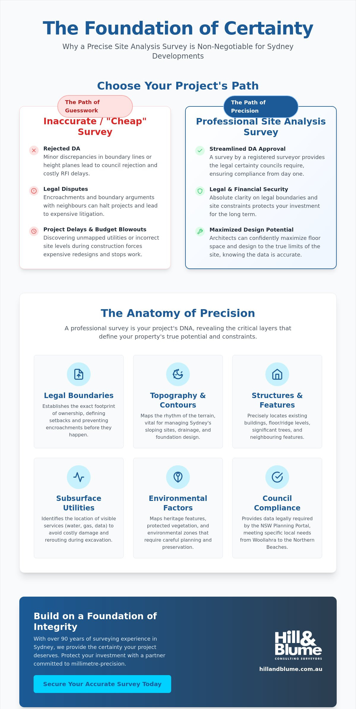
Think of your property’s survey as its unique DNA. Just as a genetic code dictates growth, an accurate site analysis survey sydney defines the limits and possibilities of your architectural vision. In a city like Sydney, where heritage sandstone meets modern glass and steep coastal cliffs, “near enough” is never good enough. We provide the millimetre-precision required to translate your physical land into a digital certainty that architects and councils trust. You aren’t just buying a map; you’re securing a partnership that values the integrity of your investment. There’s a profound difference between a cursory sketch and a professional Detail and Level Survey. While a basic plan might show where your house sits, a comprehensive survey captures the rhythm of the terrain, the exact height of a neighbour’s ridge line, and the subtle lean of a protected Eucalypt. At Hill & Blume, we’ve spent over 90 years refining this craft, ensuring every data point we provide acts as a seal of quality for your project.
The Core Components of a Professional Site Analysis
A thorough Site analysis involves a deep interrogation of the land’s physical and legal characteristics. It isn’t just about measuring distances; it’s about understanding constraints. Our specialised surveying services include:
- Mapping existing structures, floor levels, and significant vegetation.
- Identifying visible services and infrastructure that dictate your build zone.
- Establishing the precise relationship between the physical land and its legal cadastral boundaries.
Why a ‘Near Enough’ Survey Fails the Sydney DA Process
Precision isn’t a luxury; it’s a regulatory requirement. A 10cm error in a boundary location can trigger a violation of setback requirements or breach a building height plane, leading to expensive RFI delays. An accurate site analysis survey sydney ensures every line on your architect’s plan corresponds to a physical reality that won’t be challenged. Site analysis is the synthesis of topographic data and cadastral legalities. Unlike “cheap” alternatives, a survey signed by a registered surveyor carries the legal weight necessary to satisfy rigorous council standards. By choosing a partner who prioritises depth of relationship over high-volume turnover, you protect your project from the anxiety of hidden boundary disputes.
The Anatomy of Precision: What an Accurate Survey Reveals
Precision is the silent partner of every successful Sydney build. While we previously established the survey as your project’s DNA, we now examine the specific anatomical details an accurate site analysis survey sydney reveals. This process involves a meticulous peeling back of layers, exposing the physical, environmental, and legal realities that dictate your architectural journey. From the steep sandstone inclines of the Eastern Suburbs to the heritage canopies of the Inner West, every detail is a building block of your success. You deserve to move forward with a plan that reflects reality, not just an estimation.
When you engage a registered surveyor, you’re securing a legal authority whose work upholds the highest professional standards. Their expertise is anchored in the Surveying and Spatial Information Act 2002, a foundational piece of legislation for Navigating Sydney’s Local Council Requirements with absolute confidence. This precision captures several vital layers:
- Subsurface Infrastructure: Precise location of utility lines to avoid the “hidden” costs of accidental damage or complex rerouting during excavation.
- Environmental Constraints: High-definition mapping of significant vegetation and heritage features that demand preservation and careful planning.
- Legal Boundaries: Defining the exact footprint of your ownership to ensure your design stays within its rightful limits from the first day of construction.
Topography and Contours: Managing Sydney’s Sloping Sites
Sydney’s topography is beautifully varied but technically demanding. For an architect, understanding precise contour intervals is vital for drainage and excavation planning. We use high-definition equipment to capture every rock outcrop and existing retaining wall, providing a vivid picture of the terrain. This level of detail is also essential for Work-as-Executed (WAE) data, ensuring your completed project remains fully compliant with your original approvals. If you’re ready to define your property’s potential, we invite you to reach out for a personal conversation about your site’s unique needs.
Easements and Encroachments: The Legal Layer
Many of the most significant project hurdles are entirely invisible to the naked eye. Easements for drainage or utility access can limit your build zone, while historical encroachments, like a neighbor’s fence or garage, can spark costly disputes. An accurate site analysis survey sydney visualises these legal restrictions directly on your plan. Professional boundary surveys allow you to identify these issues before construction begins. It’s about proactive protection and the calm confidence that comes from knowing your design rests on a legally sound foundation.
Why Accuracy is Non-Negotiable: Avoiding DA Delays and Costly Errors
In the high-stakes environment of Sydney property development, time isn’t just money; it’s momentum. An accurate site analysis survey sydney is the single most effective tool for maintaining that momentum. When your data is flawless, the path through the NSW Planning Portal becomes a deliberate march rather than a series of retreats. There’s a direct, measurable correlation between the precision of your initial survey and the speed of your DA approval. Councils don’t look kindly on discrepancies. Even a minor mismatch between your site plan and the physical reality can trigger a formal Request for Information, stalling your project for weeks or months while you scramble to provide updated data.
Architects rely on this precision to safely maximise your property’s Floor Space Ratio (FSR). In dense urban areas like Paddington or Mosman, every millimetre counts. If your survey is out by even a small margin, your design might inadvertently breach height planes or setback controls. This mistake often isn’t discovered until the construction set-out phase, creating a catastrophic ripple effect. By then, your design is locked in, your materials are ordered, and your builder is on-site. The cost of a registered surveyor’s report is, in essence, the most valuable insurance policy you can buy for your development.
Maximising Development Potential within Local Environment Plans (LEPs)
Navigating the strictures of local LEPs requires a surgical approach to measurement. Accurate levels allow you to push the boundaries of height and setback controls with total certainty. This is particularly crucial for the Complying Development (CDC) pathway, where there’s no room for interpretation. Our team supports architects in achieving that ‘perfect fit’ on-site, ensuring that your vision is both ambitious and entirely compliant. It’s about finding the hidden opportunities within the terrain that a less experienced eye might miss. You can explore our full range of specialised surveying services to see how we provide this essential foundation.
The Cost of Inaccuracy: A Sydney Perspective
We’ve seen the consequences of ‘cheap’ surveys firsthand. Consider the financial impact of having to move a structural retaining wall by just 300mm because of an initial measurement error. The rework doesn’t just involve the physical labour; it includes new engineering certifications, potential stop-work orders, and a complete breakdown of your construction timeline. Such errors can easily cost tens of thousands of dollars in demolition and delays. At Hill & Blume, we prioritise being right the first time. We don’t compete on the lowest quote because we understand that the real cost of an inaccurate survey is far higher than the initial fee. We offer the calm confidence that comes from nearly a century of surveying integrity.
Navigating Sydney’s Local Council Requirements for Site Surveys
Sydney is not a monolith; it is a collection of distinct landscapes, each governed by its own set of rigorous planning controls. An accurate site analysis survey sydney must be meticulously tailored to meet the specific demands of your local authority. What satisfies a Development Application in the dense, heritage-rich streets of the City of Sydney or Woollahra will differ significantly from the requirements of the Northern Beaches or the North Shore. You deserve a partner who understands these nuances intimately, ensuring your project moves through the approval process without the friction of unexpected requisites.
The transition to the NSW Planning Portal, mandatory for all applications since July 1, 2021, has heightened the need for digital precision. Surveys must typically be no older than 12 months at the time of lodgement to be accepted. For projects on the Northern Beaches, this often includes specific coastal hazard mapping and bushfire zone analysis. In more urban environments like Crows Nest, the focus shifts toward the precise interplay between your property and the tight urban fabric. Whether your project is in the heart of Sydney, Newcastle, or the Central Coast, your survey data must meet the latest digital standards, including the provision of LandXML files to ensure seamless integration with government systems.
Council-Specific Survey Nuances
Each council area presents unique constraints that your surveyor must identify early. In the Eastern Suburbs, shadow diagram accuracy is paramount; your survey must capture the ridge lines and window positions of neighbouring structures to prove your design won’t unfairly impact their light. On the North Shore, councils maintain strict significant tree registers. An accurate site analysis survey sydney will map these “green constraints” with precision to avoid heavy fines or design rejections. Furthermore, meeting the stormwater and drainage requirements of Sydney Water and local councils requires a detailed understanding of existing pipe invert levels and flow paths, while for larger projects, technical consultancies such as Teams Limited provide the specialized transport planning and traffic management expertise needed to navigate complex urban infrastructure demands.
Local Expertise: The Hill & Blume Advantage Across NSW
Since 1932, Hill & Blume has been an essential part of the local fabric, navigating the evolving landscape of New South Wales planning with quiet confidence. Our 90 years of experience provide us with deep familiarity with historical cadastral records and local landmarks that newer agencies might overlook. We don’t just provide data; we provide a curated experience grounded in traditional integrity and modern technology. From the heritage sandstone of Sydney to the growing regional hubs of Newcastle and the Central Coast, we offer the local support and specialized knowledge your project requires. If you are ready to secure your project’s foundation with a team that values quality over quantity, we invite you to contact our specialist team today for a tailored consultation.
Partnering with Hill & Blume: 90 Years of Surveying Integrity
Choosing a surveyor is an act of trust. It’s the final piece of the puzzle that ensures your architectural vision is grounded in reality. While the technical aspects of an accurate site analysis survey sydney are vital, the character of the firm performing the work is what provides true peace of mind. You aren’t just looking for a data provider; you’re seeking a partner who understands that your property is a significant chapter in your life’s story. At Hill & Blume, we’ve spent nearly a century refining a boutique experience that prioritises the depth of our relationship with you over high-volume turnover.
Our signature is a sophisticated blend of traditional integrity and modern technology. We believe that the precision of our instruments should be matched by the warmth of our service. This approach is why Sydney’s leading architects and developers have trusted us since 1932. When you engage our team, you receive a level of personalised attention that larger, more clinical corporate agencies simply cannot replicate. We treat every project as a curated experience, ensuring that every measurement is a testament to our commitment to quality.
A Legacy of Precision in Sydney
Celebrating over nine decades of land measurement excellence is a milestone we don’t take lightly. We’ve witnessed the evolution of our tools firsthand, moving from the steady hand required for manual theodolites to the sophisticated speed of advanced digital mapping and LandXML data. This historical perspective gives us a unique advantage when interpreting older cadastral records that define many of Sydney’s most prestigious suburbs. Hill & Blume doesn’t just measure land; we safeguard property legacies. Our work ensures that the boundaries established today will stand the test of time for generations to come.
Your Next Steps for Project Certainty
Initiating your accurate site analysis survey sydney is a seamless process designed to respect your time and intelligence. It begins with a considered conversation where we listen to your aspirations and identify the specific constraints of your site. Following this, we provide a tailored fee proposal that reflects the unique requirements of your project. During the on-site measurement phase, our registered surveyors work with a quiet, professional diligence that reflects our brand’s refined aesthetic. We invite you to take the first step toward architectural integrity today. Connect with our registered surveyors to secure your site’s foundation.
Building Your Legacy on a Foundation of Certainty
Your architectural vision deserves a start that is as precise as it is inspired. By prioritising an accurate site analysis survey sydney, you remove the shadow of doubt from your development application and protect your investment from the ripple effect of measurement errors. You’ve seen how meticulous data streamlines council approvals and allows for the safe maximisation of your site’s potential. It’s about transforming physical terrain into a reliable digital blueprint that architects and builders can trust without hesitation.
Since 1932, Hill & Blume has served as a specialized local authority, providing the calm confidence that only nearly a century of experience can offer. As Registered NSW Surveyors and specialists in Detail and Level Surveys, we ensure your project is anchored by traditional integrity and modern technical excellence. We invite you to secure your project’s success with a Hill & Blume Site Analysis Survey. Let’s work together to ensure your Sydney property remains a source of pride and legal security for years to come. Your project’s integrity starts with the very first measurement, and for those looking to extend that professional vision into the digital space, هوية للحلول التسويقية والرقمية provides expert marketing solutions to build a lasting brand identity.
Frequently Asked Questions
What is the difference between a site analysis survey and a boundary survey?
A site analysis survey provides a comprehensive portrait of your property’s physical landscape, including contours, levels, existing structures, and significant vegetation. In contrast, a boundary survey focuses strictly on defining the legal limits and corners of your land. While the boundary survey sets the frame, the site analysis fills in the essential details your architect needs to design within that frame.
How long does a site analysis survey typically take in Sydney?
Most projects require approximately one to two weeks from the initial site visit to the delivery of your final digital plans. This timeframe allows our surveyors to conduct thorough field measurements and process the data with the millimetre-precision your project deserves. Complex sites with dense vegetation or steep terrain may require additional time for meticulous data curation.
Do I need a new survey if I already have the original title plans?
Yes, you’ll almost certainly need a contemporary survey because original title plans don’t show the current physical state of the land. Modern Development Applications require detailed topographic data, existing structural footprints, and utility locations that aren’t present on historical documents. Additionally, most Sydney councils require survey data to be no more than 12 months old at the time of lodgement.
Can a site analysis survey help with a boundary dispute in NSW?
While a site analysis provides helpful context, a formal Boundary Survey or Identification Survey is the specific legal instrument required to resolve disputes in New South Wales. These surveys must be performed by a registered surveyor to carry legal weight. They provide the definitive evidence needed to settle disagreements over encroachments or fence placements with absolute certainty.
How much does an accurate site analysis survey cost in Sydney?
The investment for an accurate site analysis survey sydney is determined by the specific size, slope, and complexity of your property. Rather than offering generic flat rates, we provide tailored fee proposals that reflect the precise level of detail your project requires. This bespoke approach ensures you receive a high-quality foundation for your design without paying for unnecessary extras.
What equipment do Hill & Blume use to ensure survey accuracy?
We utilize high-definition total stations and advanced GNSS technology to capture the unique rhythm of your site’s terrain. This hardware is paired with sophisticated digital mapping software that translates physical measurements into precise LandXML files. Our commitment to modern technology ensures that every data point we provide is a reliable building block for your architectural vision.
Is a site analysis survey required for a Complying Development Certificate (CDC)?
A Detail and Level survey is a mandatory requirement for any CDC application in New South Wales. It provides the empirical evidence that your proposed development strictly adheres to state-mandated height limits, setbacks, and floor space ratios. Without this accurate data, a private certifier cannot verify that your project meets the non-discretionary standards for fast-tracked approval.
Why should I hire a registered surveyor instead of a general measurement service?
Only a registered surveyor has the legal authority and professional training to define property boundaries and certify plans for government authorities in NSW. General measurement services lack the rigorous oversight and legal accountability essential for an accurate site analysis survey sydney. Choosing a registered professional protects you from the risk of rejected applications and provides long-term legal security for your property assets.
Disclaimer
The information provided in articles published on this website is for general informational purposes only. While we make every effort to ensure the accuracy, completeness, and timeliness of the content, the material is based on our understanding of the industry at the time of writing and may not reflect the most current developments, regulations, or standards. All opinions expressed in our articles are those of the respective authors and do not necessarily represent the official position of the website or its affiliates. The content should not be considered professional, legal or technical advice, and should not be relied upon as a substitute for consultation with qualified professionals