

Have you ever looked at your garden’s edge and felt a nagging doubt that the fence line doesn’t quite match the heritage of your title? It’s a common anxiety for many homeowners, especially when weathered survey plans seem to tell a different story than the physical markers on the ground. Finding a path for resolving property line disputes nsw doesn’t have to be defined by friction or the daunting shadow of the Land and Environment Court. You deserve clarity. You deserve a resolution that honors both your land rights and your daily peace of mind.
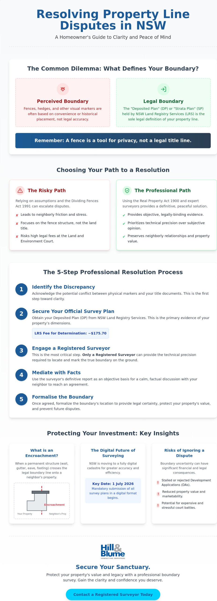
We understand that your home is more than just an asset; it’s a sanctuary where you’ve invested your time and care. It’s natural to feel protective of your boundaries, yet you’re likely hesitant to risk a neighborly relationship over a few centimeters of soil. This guide offers a professional roadmap to settling these disagreements with technical precision and legal clarity. We’ll explore the essential role of registered surveyors, the $175.70 LRS fee for official boundary determinations, and how the shift to digital survey plans by 1 July 2026 provides a new level of accuracy. You’ll discover how to secure a legally binding boundary that preserves your property’s value without the need for a stressful court battle.
Key Takeaways
- Understand why visual markers like fences or hedges aren’t legal boundaries and how this distinction is the first step toward clarity.
- Navigate the legal landscape of the Real Property Act 1900 to find the professional pathways for resolving property line disputes nsw with confidence.
- Learn why only a Registered Surveyor can provide the technical precision required to establish the “truth” of your land’s edge.
- Discover a structured, peaceful approach to resolution that prioritizes both your property rights and your relationship with your neighbors.
- Gain insights into how historical survey records and modern digital standards work together to safeguard your home’s value and your legacy.
Understanding the Roots of Boundary Disputes in NSW
A property boundary is more than a line on a map; it’s the invisible threshold of your personal sanctuary. A dispute typically arises when the physical reality of your yard clashes with the technical data held by the state. You might believe your land extends to a specific row of trees, while your neighbor’s perspective shifts those few crucial inches toward your veranda. Resolving property line disputes nsw requires moving beyond these subjective feelings and grounding the conversation in objective, legal fact. Your land is your legacy, and ensuring its integrity is a vital part of property custodianship.
Disagreements often simmer for years, only boiling over when a tangible change occurs. You might decide to install a pool, remove an aging gum tree, or finally replace a leaning timber fence. Suddenly, those few centimeters of soil become the focal point of intense stress. These conflicts are rarely about the land itself; they’re about the certainty of ownership and the protection of your home’s future value. When these moments arise, the path forward involves a blend of historical research and modern technical precision.
Fences vs. Legal Boundaries: The Common Misconception
It’s easy to assume that a fence line is a definitive marker of your territory. However, the Dividing Fences Act 1991 focuses on the shared responsibility of the structure rather than the underlying land title. Many older Sydney suburbs feature “give and take” fences, where historical owners placed barriers around obstacles like rock outcrops or thickets rather than following the true title line. Relying on these visual cues without a professional boundary survey can lead to significant legal confusion when you eventually decide to sell or renovate. A fence is a tool for privacy, but it’s the registered survey plan that defines your rights.
The Risks of Encroachments and Title Discrepancies
In the context of Australian property law, an encroachment occurs when a permanent structure crosses the boundary of an adjoining property. This isn’t limited to ground-level walls; it includes overhanging eaves, gutters, or even the footings of a garage. These discrepancies between your physical site and the NSW Land Registry Services records can create a cascade of complications. A minor encroachment might seem trivial until a Council inspector identifies it during a Development Application (DA) process, potentially stalling your project for months. Resolving property line disputes nsw early ensures that your property remains a clear and marketable asset, free from the entanglements of boundary uncertainty. By aligning physical structures with legal titles, you provide a secure foundation for any future improvements or transactions.
The Legal Framework: Navigating NSW Property Laws
The legal architecture of New South Wales is designed to offer certainty, yet it remains complex for the uninitiated. At its heart lies the Real Property Act 1900, the legislation that establishes the Torrens Title system we rely on today. This system ensures that the state guarantees your ownership, but it relies heavily on the accuracy of the records held by NSW Land Registry Services (LRS). As we move toward a fully digital cadastre, with a mandate for digital survey plans commencing on 1 July 2026, the technical precision of these records is becoming more vital than ever. Understanding these laws is the first step in protecting your most significant investment.
While many people look toward the Dividing Fences Act 1991 when a dispute arises, it’s essential to remember that this Act primarily deals with the cost and quality of the fence itself. It doesn’t legally redefine where your land ends. For matters of true boundary integrity, the Land and Environment Court of NSW is often cited, but it’s a path paved with high fees and emotional strain. We believe in finding a more elegant solution first. The legal system provides pathways that prioritize evidence and technical accuracy over adversarial litigation, allowing for a more peaceful resolution.
Accessing and Interpreting Your NSW Survey Plan
To begin the journey of resolving property line disputes nsw, you must first secure your Deposited Plan (DP) or Strata Plan (SP) from the LRS. These documents are the primary evidence of your property’s dimensions. However, reading a historical plan is an art as much as a science. Old plans might use chains and links or reference landmarks that no longer exist. A simple Title Search confirms who owns the land, but only a physical boundary identification by a professional can reconcile those ancient measurements with your current garden wall. If you find yourself overwhelmed by the technicalities of your Deposited Plan, speaking with a local specialist can provide the clarity you need to move forward.
The Formal Boundary Determination Process
If informal discussions fail, Part 14A of the Real Property Act provides a powerful, non-adversarial tool: an application for a boundary determination to the Registrar-General. For a fee of $175.70, which is the verified rate for the 2025/2026 financial year, you can seek an official ruling. This process requires a formal survey plan to accompany the application, ensuring that the decision is based on technical truth rather than neighborly hearsay. This pathway offers a legally binding confirmation that can settle resolving property line disputes nsw without the exhaustion of a full court battle. It’s a structured approach that respects the intelligence of all parties involved while providing the finality you require.
The Essential Role of a Registered Surveyor in Dispute Resolution
While the legal framework provides the rules of engagement, a Registered Surveyor provides the ground truth. They are the only professionals with the legal authority to define where one property ends and another begins. In the delicate process of resolving property line disputes nsw, the surveyor acts as an impartial expert. Their duty isn’t to “win” a piece of land for a client; instead, their loyalty lies with the integrity of the cadastre. They bridge the gap between ancient paper records and the physical soil beneath your feet.
The work often begins with a meticulous search for physical evidence that the naked eye might miss. This involves more than just looking at your fence. A surveyor hunts for original survey pegs, often buried deep beneath decades of topsoil, and reference marks etched into street kerbs or old brick walls. By cross-referencing these physical artifacts with historical Deposited Plans, they reconstruct the boundary with mathematical certainty. This level of detail is what transforms a neighborhood disagreement into a settled matter of fact.
Why Only a Registered Surveyor Can Define Your Boundary
It’s a common mistake to assume any land measurer or draftsperson can settle a boundary question. In New South Wales, the Board of Surveying and Spatial Information (BOSSI) maintains a strict registry to ensure only qualified individuals hold this responsibility. A Registered Surveyor carries significant professional liability; their signature on a plan is a legal guarantee of accuracy that carries immense weight in a courtroom. You can learn more about the rigorous standards required in our guide on what is a registered surveyor in NSW. Without this specific accreditation, a survey report lacks the legal standing necessary for resolving property line disputes nsw effectively.
The Identification Survey: Your Primary Evidence Tool
When tensions rise, the Identification Survey (often called an “Ident”) becomes your most valuable asset. This comprehensive report details the relationship between the legal boundary and the physical structures on the site. It identifies eaves that overhang the line, garages built too close to the edge, and the exact position of dividing fences. This document protects you during a property purchase by uncovering hidden liabilities before you sign a contract. The Identification Survey stands as the gold standard for NSW property boundary proof, offering an unassailable record of your land’s true extent. It provides the clarity needed to move forward with confidence, ensuring your property rights are respected and preserved for the long term.
Practical Steps to Resolve a Property Line Disagreement
Taking the first step toward resolving property line disputes nsw is often a matter of shifting the focus from personal emotion to technical evidence. While a disagreement over a few centimeters of garden can feel intensely personal, the solution is found in a structured, professional process. By following a clear escalation path, you can often reach a peaceful conclusion that protects your land rights without the need for aggressive litigation. This journey begins with a conversation and ends with the certainty of a verified boundary.
- Step 1: Informal Discussion. Invite your neighbor to review your existing documentation together. Sometimes, simply looking at the same Deposited Plan can clear up minor misunderstandings before they grow.
- Step 2: Professional Boundary Survey. If the confusion persists, engage a Registered Surveyor to perform a formal Boundary Survey. This provides the objective truth required to move past hearsay.
- Step 3: Fact Sharing. Present the survey findings to your neighbor. Most reasonable parties will accept the findings of a licensed professional as a definitive answer.
- Step 4: Community Justice Centres (CJC). For persistent disagreements, NSW offers free mediation through CJCs. This is a vital step for maintaining community harmony.
- Step 5: Specialized Legal Counsel. If the survey reveals significant encroachments or triggers complex claims like adverse possession, it is time to seek a solicitor who specializes in property law.
Using a Boundary Survey as a Negotiation Framework
A professional survey report is more than a piece of paper; it is a powerful negotiation tool. When you present a Registered Surveyor’s findings, you are moving the conversation away from “he said, she said” and toward mathematical reality. We often recommend “marking the boundary” physically with new survey pegs. This visible, tangible marker often causes the other side to drop unfounded claims, as the physical presence of professional markers is difficult to argue against. If you are ready to establish this level of clarity, reach out to our team to discuss your specific site requirements.
Mediation and the NSW Civil and Administrative Tribunal (NCAT)
In cases where the dispute specifically involves a shared barrier, the NSW Civil and Administrative Tribunal (NCAT) provides an accessible forum under the Dividing Fences Act 1991. NCAT is designed to be less formal than a court, but it still requires high-quality evidence. Your surveyor’s plan will be the centerpiece of any hearing, providing the tribunal with the technical data needed to make a fair ruling. Choosing mediation or a tribunal hearing can save you thousands in legal fees compared to the Land and Environment Court, ensuring that resolving property line disputes nsw remains a manageable and dignified process.
Protecting Your Property Rights with Hill & Blume
Hill & Blume represents more than a surveying firm; we’re custodians of Sydney’s historical landscape. With over 90 years of records, we offer a depth of insight that larger, clinical agencies simply cannot replicate. When you engage our team for resolving property line disputes nsw, you aren’t just getting a measurement. You’re receiving a legacy of precision. We understand that your land is your most significant asset, and it deserves a level of care that honors its heritage and its future.
Our boutique approach ensures you speak directly with the experts handling your land. We believe in depth of relationship over high-volume turnover, allowing us to provide a tailored service that respects your time and your intelligence. This personal touch is what distinguishes us. By choosing a specialized local authority, you gain a partner who is deeply rooted in the local culture and committed to traditional integrity.
Precision Surveying for Peace of Mind
Precision is the only language that holds weight when a boundary is in question. We blend the latest satellite technology with a deep reservoir of historical knowledge to find the truth of your land’s edge. Whether you’re planning a new extension or verifying an old fence, ensuring your construction set-out is 100% compliant with legal boundaries is essential. It’s the difference between a seamless project and a legal nightmare.
We provide the “Hill & Blume” seal of quality, a standard of accuracy that stands up under the scrutiny of the Land and Environment Court. An error of a few centimeters today can transform into a significant liability in a decade. By being proactive with your boundary identification, you prevent resolving property line disputes nsw from ever becoming a necessity. We help you build with confidence, knowing your investment is protected by technical excellence.
Professional Consultation for Complex Boundary Issues
Complex boundary issues require more than just raw data; they require strategic, considered consultation. We provide customized advice for residential, commercial, and strata properties across the Sydney region. Our role is to provide your legal team with rock-solid technical evidence that leaves no room for ambiguity. We move smoothly from identifying your aspirations to offering a tailored solution that fits your specific site.
Our communication rhythm is steady and deliberate, much like the lifestyle we aim to protect. We don’t believe in aggressive tactics. Instead, we offer a partnership-oriented narrative that prioritizes your peace of mind. Every survey we perform is a considered conversation between the historical record and the modern site. This balance ensures that your property rights are not just identified, but truly secured.
To secure your property boundaries with a professional survey and protect your home’s future value, Contact Hill & Blume today. We’re here to provide the clarity and confidence you need to enjoy your property to its fullest extent.
Defining Your Path to Boundary Clarity
Your home is a sanctuary where the physical landscape should reflect the legal integrity of your title. We’ve explored how technical evidence and the expertise of a Registered Surveyor provide the only definitive answer to neighborly disagreements. By choosing a path of professional verification over adversarial conflict, you protect your land rights while preserving the harmony of your local community. Resolving property line disputes nsw is ultimately about replacing uncertainty with the calm confidence of an unassailable record.
Securing this clarity requires a partner with deep roots in the region and a commitment to precision. With over 90 years of NSW surveying expertise and BOSSI-accredited specialists, our team ensures your land is measured with the highest standard of craftsmanship. Whether you’re in Sydney, Newcastle, or the Central Coast, we provide the technical evidence needed for complete property law compliance. Secure your property boundaries with a Registered Survey from Hill & Blume today. You deserve the peace of mind that comes from knowing exactly where your sanctuary begins.
Frequently Asked Questions
Can I resolve a boundary dispute without going to court in NSW?
Yes, you can reach a resolution without the stress of a courtroom. Most disagreements are settled through a combination of professional survey data and structured mediation. Community Justice Centres offer free assistance to facilitate these conversations in a neutral environment. For a more formal but non-judicial path, you can apply for a boundary determination through the Registrar-General under the Real Property Act 1900.
How much does a boundary survey cost in NSW for a dispute?
The investment for a survey depends on the unique characteristics of your land and its history. Factors such as the age of your title, the complexity of the terrain, and the proximity of established survey markers in your street all influence the required effort. While we don’t provide flat rates, we focus on delivering a level of precision that protects your property’s long-term value and prevents future legal costs.
What happens if my neighbour’s garage is over my property line?
A garage crossing your boundary is a legal encroachment that requires immediate professional verification. You should first commission an Identification Survey to document the exact extent of the intrusion. Once the facts are established, solutions might include a boundary adjustment, a formal easement for the structure, or, in extreme cases, a court order for removal. Having technical data is the first step in resolving property line disputes nsw involving permanent structures.
Is a fence always the legal boundary in New South Wales?
A fence line is rarely a definitive legal boundary in New South Wales. Fences are often constructed based on visual guesswork or historical convenience, such as avoiding a large tree or rock. The only legally recognized boundary is the one described in your Deposited Plan or Strata Plan. If your fence doesn’t align with these records, the technical survey data always takes precedence over the physical barrier.
What is the “Dividing Fences Act” and how does it help with property lines?
The Dividing Fences Act 1991 is a piece of legislation that manages the shared costs and maintenance of fences. It provides a framework for neighbours to agree on what constitutes a “sufficient” fence and how to split the bill fairly. It’s important to remember that this Act doesn’t settle where the land ends. It’s a tool for shared responsibility, not for defining property ownership.
How long does a Registered Surveyor take to identify a boundary?
Most boundary identifications are completed within a timeframe of one to three weeks. This period allows our experts to conduct thorough historical research at the Land Registry Services and perform meticulous field measurements. We prioritize depth and accuracy over speed to ensure your final report is unassailable. The complexity of your specific suburb’s records can occasionally extend this timeline to ensure every detail is correct.
Can I move a survey peg if I think it is in the wrong place?
You must never move or tamper with a survey peg or reference mark. Doing so is a serious offense under the Surveying and Spatial Information Act 2002 and can lead to significant fines. These markers are essential pieces of public infrastructure used to maintain the state’s land registry. If you believe a peg’s been placed incorrectly, the only legal recourse is to engage another Registered Surveyor to verify the position.
What should I do if my neighbour refuses to accept a professional survey report?
When a neighbour refuses to accept a professional report, you have access to formal state-led resolution pathways. You can escalate the matter by applying for a boundary determination through the Registrar-General. This process is specifically designed for resolving property line disputes nsw where two parties cannot agree on a surveyor’s findings. The resulting determination is legally binding and provides the finality you need to move forward with your property plans.
Disclaimer
The information provided in articles published on this website is for general informational purposes only. While we make every effort to ensure the accuracy, completeness, and timeliness of the content, the material is based on our understanding of the industry at the time of writing and may not reflect the most current developments, regulations, or standards. All opinions expressed in our articles are those of the respective authors and do not necessarily represent the official position of the website or its affiliates. The content should not be considered professional, legal or technical advice, and should not be relied upon as a substitute for consultation with qualified professionals