

What if the most significant hurdle to your property’s potential isn’t the terrain or the budget, but the hidden nuances within a council’s Local Environmental Plan? It’s common to feel caught between the ambitious designs of a builder and the rigid, often conflicting feedback from local authorities. You likely understand that even a minor oversight in Minimum Lot Size or zoning can lead to months of expensive delays in the DA process, leaving you feeling more like a bureaucrat than a developer. We believe your journey deserves a more refined approach, grounded in precision and local expertise.
This guide is designed to replace that uncertainty with a clear, expert-led roadmap, ensuring your project aligns perfectly with the latest council requirements for subdivision nsw from your very first survey. We’ll explore the 2026 regulatory landscape, from the new Housing and Productivity Contribution rates to the streamlined pathways introduced by the Planning System Reforms Act. By the end of this article, you’ll have the clarity needed to navigate the lodgement of your Subdivision Certificate with confidence, transforming complex regulations into a seamless path toward maximised land value.
Key Takeaways
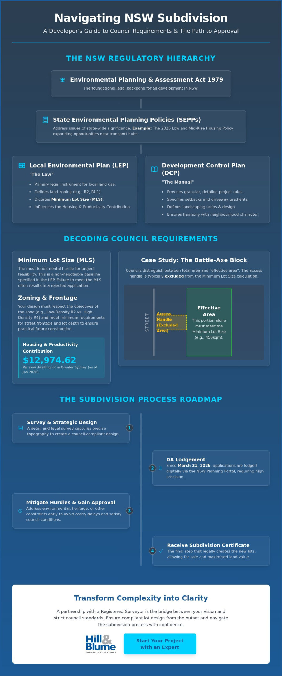
- Decode the hierarchy between State Environmental Planning Policies and Local Environmental Plans to ensure your development strategy is built on a solid legal foundation.
- Master the nuances of council requirements for subdivision nsw by understanding how Minimum Lot Size and “effective area” calculations impact your land’s true potential.
- Navigate the transition from a preliminary survey to the final Subdivision Certificate with a clear, step-by-step roadmap designed to minimize costly delays.
- Identify and mitigate environmental and heritage constraints early, protecting your investment from the high costs of unforeseen planning hurdles.
- Discover how a partnership with a Registered Surveyor acts as a bridge between your vision and strict council standards, ensuring compliant lot design from the outset.
Understanding the NSW Subdivision Regulatory Framework
To understand your property’s potential, you must first understand the legal architecture that governs it. The Environmental Planning and Assessment Act 1979 (EP&A Act) serves as the backbone for all development in the state, providing the structure for how land is used, protected, and shared. This modern framework is built upon the historical foundations of NSW land administration, ensuring every new boundary respects both heritage and future growth. For any developer, understanding the nuances of council requirements for subdivision nsw is the first step in unlocking a site’s true value.
You’ll encounter a clear hierarchy of rules during your project. State Environmental Planning Policies (SEPPs) address issues of state significance, such as the 2025 Low and Mid-Rise Housing Policy which recently expanded opportunities near transport hubs. However, your daily interactions will mostly involve local council requirements for subdivision nsw. These rules vary significantly because each local government area faces unique challenges, from the density of Sydney’s inner suburbs to the environmental sensitivities of regional NSW. Since the Planning System Reforms Act 2025 took effect on March 21, 2026, the process has moved almost entirely to the NSW Planning Portal. This digital shift aims to streamline approvals, though it requires a high degree of precision in your initial documentation.
The Role of the Local Environmental Plan (LEP)
Each council area operates under its own LEP, which defines what’s permissible on your specific lot. This document is the primary legal instrument for local land use. It dictates zoning, whether you’re situated in a low-density residential zone (R2) or a more expansive rural setting (RU1). These zones determine the minimum lot size required for a legal subdivision. Without meeting these baseline standards, a proposal is unlikely to move past the initial assessment phase. Your zoning also influences the Housing and Productivity Contribution, which as of January 2026, is set at $12,974.62 per new dwelling lot in Greater Sydney.
Development Control Plans (DCPs): The Detail
If the LEP is the law, the Development Control Plan (DCP) is the manual. It provides the granular detail that shapes the physical appearance of your project. You’ll find specific rules here regarding setbacks, driveway gradients, and required landscaping ratios. These standards ensure that new lots integrate harmoniously with the existing neighborhood character. To satisfy these requirements, a professional detail and level survey is essential. It captures the precise topography and existing features of your land, allowing for a design that meets council expectations from the very first draft.
Key Council Requirements: Minimum Lot Size and Zoning
You’ve identified the potential in your land. Now, you must reconcile that vision with the mathematical reality of council requirements for subdivision nsw. The most fundamental hurdle you’ll face is the Minimum Lot Size (MLS). This figure isn’t merely a suggestion; it’s the baseline for project feasibility. If your land doesn’t meet the MLS specified in the Local Environmental Plan, your path to approval becomes significantly more complex and often impossible without a formal variation request.
Calculating area isn’t always as simple as looking at a title deed. For battle-axe blocks, councils distinguish between the total land size and the “effective area”. The access handle, that long strip of driveway connecting the rear lot to the street, is typically excluded from the minimum area calculation. If your local LEP requires a 450sqm lot, your design must provide that space entirely within the building envelope, excluding the handle. Precision at this stage is vital. A few centimeters can be the difference between a profitable development and a rejected application.
Zoning objectives serve to maintain the unique character of your neighborhood while meeting broader density targets. Whether you’re working within a low-density R2 zone or a more intensive R4 area, your proposal must respect the established streetscape. Frontage and depth requirements ensure that each new lot is not only legal but also practical for future construction. Before you commit to a design, it’s wise to speak with a professional surveyor to confirm your plans align with these local nuances.
Infrastructure and Service Requirements
Council expects every new lot to be “ready to build” before they grant final approval. This means ensuring seamless connections to water, sewer, and electricity networks. Stormwater management is a critical focus area, often requiring the creation of drainage easements to manage runoff responsibly. Understanding these Subdivision Certificate requirements early prevents expensive retrofitting later. We recommend an identification survey to verify the exact location of existing services and boundaries, providing a clear foundation for your infrastructure planning.
Access and Transport Standards
New lots must have safe, reliable access to the public road network. Council rules for shared driveways or new road construction are detailed, focusing on sightlines and vehicle maneuvering areas. You must demonstrate that a standard vehicle can enter and exit the property in a forward direction, especially on busier roads. Our surveyors work closely with engineers to mark out these access points with surgical precision, ensuring your civil works meet council’s stringent transport standards without compromise.
The NSW Subdivision Process: From DA to Certificate
Your vision for the land now moves from a concept into a structured sequence of approvals. This journey is governed by a meticulous timeline where each milestone builds upon the last. To meet the council requirements for subdivision nsw, you must navigate a defined process that transforms a single title into multiple, high-value assets. It’s a path that rewards precision and punishes haste, making the role of your surveyor central to every phase.
The process begins with a Preliminary Survey. This captures the “as-is” state of your property, recording every contour, tree, and existing structure. It’s the canvas for your design. Once your proposal is ready, you’ll lodge a Development Application (DA) via the NSW Planning Portal. This is where council assesses your design against the LEP and DCP standards. Following DA approval, you’ll likely move to the Construction Certificate (CC) phase for any required physical works, such as installing drainage or driveways. As of July 1, 2026, the NSW Planning Portal service fee for a Subdivision Works Certificate is $47.
The final milestone is the Subdivision Certificate. This is the official seal of approval confirming all conditions of the DA have been satisfied. The portal service fee for this certificate is also $47, separate from council’s specific assessment fees. Achieving this certificate allows you to lodge your plans with NSW Land Registry Services, officially creating the new titles.
Preparing the Plan of Subdivision
The document you submit for your DA is a draft, a visual representation of your intent. However, the final Plan of Subdivision is a precise legal instrument that defines the new boundaries with absolute certainty. By law, only a Registered Surveyor can sign this document. Their signature is a guarantee that the new lots are accurately placed and comply with the approved design. For a deeper look at these technical stages, explore our subdivision survey guide.
Meeting Section 88B Instrument Requirements
Accompanying your plan is the Section 88B instrument. This document defines the easements, restrictions, and covenants that run with the land. Council uses these instruments to protect public infrastructure, such as drainage pipes, or to maintain neighborhood standards through building envelopes. Ensuring these are legally sound is critical; they don’t just satisfy council requirements for subdivision nsw, they protect the future owners and the long-term value of your development.
Common Hurdles: Environmental and Heritage Constraints
Your property’s potential is often defined by the layers of history and nature that rest upon it. While zoning provides the broad strokes of what’s possible, environmental and heritage overlays represent the fine-grained reality of council requirements for subdivision nsw. Whether your land is flagged as Bushfire Prone or sits within a Flood Planning area, these constraints dictate the buildable area of your proposed lots. Neglecting these nuances during the design phase is a frequent cause for DA rejection, often resulting in expensive redesigns that could have been avoided with early expert insight.
Heritage conservation areas present a unique challenge. In these pockets of Sydney and regional NSW, subdivision isn’t just about creating new titles; it’s about respecting the existing streetscape and architectural narrative. You may find that council requires specific lot widths or building envelopes to ensure the new development doesn’t detract from the area’s character. Similarly, significant vegetation can trigger the Biodiversity Offset Scheme, requiring a careful balance between your development goals and ecological preservation. At Hill & Blume, we identify these constraints during our initial assessment, ensuring your design is both aspirational and compliant.
Topography and Land Slope Issues
Steep sites face a higher level of scrutiny from council assessors. If a proposed lot is too steep to support a standard dwelling without excessive excavation, it may be deemed unbuildable. We use a professional contour and detail survey to prove the viability of your design. This data allows you to manage retaining walls and boundary levels accurately, preventing drainage issues that could impact neighboring properties and stall your approval.
Encroachments and Boundary Disputes
It’s surprisingly common to discover that a fence or a garden shed isn’t where it’s supposed to be. These encroachments can become major roadblocks when you’re trying to finalize a subdivision, as council typically requires all boundary issues to be resolved before they’ll issue a certificate. A boundary survey is the only legal way to resolve encroachment issues in NSW. Identifying these discrepancies early allows for a considered conversation with neighbors rather than a frantic legal dispute at the eleventh hour. If you suspect your land is subject to complex overlays or boundary uncertainties, contact our team today for a professional assessment that secures your project’s future.
Partnering with Hill & Blume for Subdivision Success
Success in property development is rarely the result of a single brilliant idea; it’s the outcome of meticulous planning and expert partnerships. At Hill & Blume, we bring over 90 years of heritage to your project, offering a depth of local knowledge that larger, more clinical agencies simply can’t match. We understand that meeting council requirements for subdivision nsw is a multi-faceted challenge that requires more than just technical skill. It requires a partner who understands the unique character of your regional area and the specific expectations of your local council.
Our boutique approach ensures you receive personalized advice directly from a Registered Surveyor. We act as the vital technical bridge between your architects, engineers, and council assessors. This collaborative narrative ensures that everyone is working from the same precise data set, from the moment we perform the initial construction set-out to the delivery of the final WAE (Work-as-Executed) report. This continuity of service mirrors the seamless experience we aim to provide, ensuring that no detail is lost in translation between the design and construction phases. We prioritize the depth of our relationships over high-volume turnover, treating your property with the craftsmanship it deserves.
Why a Registered Surveyor is Your Best Asset
In the complex world of NSW property, a Registered Surveyor’s signature carries significant legal weight. It’s the seal of quality that reassures both you and the council that every boundary and easement is exactly where it should be. By providing accurate, reliable data, we significantly reduce your project risk, preventing the costly disputes or redesigns that often plague less rigorous developments. You aren’t just hiring a technician; you’re engaging a specialized authority with a refined aesthetic for detail. To understand the full scope of this role, you might find our Registered Surveyor guide helpful for your 2026 planning.
Starting Your Subdivision Journey Today
The path to a successful subdivision begins with a considered conversation. We invite you to book an initial consultation where we can assess your site’s feasibility against current council requirements for subdivision nsw. This allows us to identify potential hurdles early, from zoning restrictions to environmental overlays, before you commit to a full development schedule. We’ll create a tailored survey plan specifically for your council area, ensuring every requirement is met with calm confidence and professional integrity. Ready to subdivide? Contact the experts at Hill & Blume to secure your property’s future and begin your journey with a partner who values quality over volume.
Securing Your Property’s Legacy
Transforming a single parcel of land into a collection of curated lots requires more than just a vision; it demands a mastery of the finer details. You’ve seen how the interplay between State policies and local zoning dictates the true potential of your site. By understanding the nuances of council requirements for subdivision nsw and identifying environmental constraints early, you position your project for a seamless transition from a draft plan to a final Subdivision Certificate. This precision is what distinguishes a successful development from a stalled application.
At Hill & Blume, we provide the steady hand and expert insight needed to navigate these complexities. With over 90 years of Sydney surveying expertise, our Registered NSW Surveyors specialize in complex DA and subdivision plans that respect both your aspirations and the local fabric. We believe that every boundary we mark is a promise of quality and a step toward a lasting legacy. When you’re ready to unlock the full value of your land, we’re here to ensure your journey is as polished as the final result.
Partner with Hill & Blume for your next NSW subdivision project and experience the boutique advantage of true surveying craftsmanship. Your property’s future is waiting to be defined.
Frequently Asked Questions
What is the minimum lot size for subdivision in NSW?
There is no universal minimum lot size across the state. Instead, the requirement is determined by your local council’s Local Environmental Plan (LEP). These standards vary significantly based on your land’s specific zoning, such as R2 Low Density or RU1 Primary Production. You should consult the LEP maps to confirm the exact threshold for your property before beginning any design work.
How much does it cost to subdivide land in NSW in 2026?
Total costs depend on your project’s scale, but several government fees are fixed for 2026. As of January 1, 2026, the Housing and Productivity Contribution for residential subdivisions is $12,974.62 per new lot in Greater Sydney and $8,649.75 in regional areas like the Illawarra-Shoalhaven. Additionally, the NSW Planning Portal charges a service fee of $47 for a Subdivision Certificate application, while the DA fee unit is set at $113.90 for the 2025/26 period.
Can I subdivide my land without a Registered Surveyor?
No, you cannot legally subdivide land in NSW without a Registered Surveyor. Only a Registered Surveyor has the legal authority to sign the final Plan of Subdivision and the accompanying Section 88B instrument. Their signature acts as a guarantee of accuracy and compliance, ensuring that your new titles are legally sound and recognized by NSW Land Registry Services.
What is a Subdivision Certificate and why do I need it?
A Subdivision Certificate is the final approval issued by your local council or a private certifier. It confirms that you’ve satisfied all conditions of your development consent and that the land is ready to be officially divided. You must obtain this certificate to lodge your plans for registration; it’s the final step in creating individual titles for your new lots.
How long does the council approval process take for a subdivision?
While timelines vary by council, the Planning System Reforms Act 2025 has introduced streamlined pathways for low-risk projects to accelerate the process. Generally, you should allow several months for the initial Development Application assessment, followed by time for construction and final certification. Navigating the council requirements for subdivision nsw with an expert from the outset can often prevent the common delays associated with non-compliant submissions.
What is a Section 88B instrument in a subdivision plan?
A Section 88B instrument is a legal document that accompanies your subdivision plan to create easements, restrictions, and covenants. It defines how the land can be used, such as protecting drainage pipes or establishing building envelopes. These instruments are essential for managing shared infrastructure and ensuring that future owners understand the rights and responsibilities attached to their specific lot.
Can I subdivide land that is in a bushfire-prone area?
Yes, subdivision is possible in bushfire-prone areas, though it triggers stricter design and safety standards. You’ll need to satisfy the requirements of “Planning for Bush Fire Protection,” which may involve creating Asset Protection Zones or specific access requirements for emergency vehicles. These environmental overlays are a critical part of the council requirements for subdivision nsw and must be addressed in your initial proposal to ensure site safety.
What is the difference between a strata subdivision and a torrens title subdivision?
Torrens title subdivision involves dividing land into separate parcels where you own the land and the space above it entirely. In contrast, a strata subdivision usually applies to multi-level developments or townhouses where you own an individual “lot” or air space while sharing common property like driveways or gardens. Each pathway has distinct surveying requirements and unique long-term management implications for the future property owners.
Disclaimer
The information provided in articles published on this website is for general informational purposes only. While we make every effort to ensure the accuracy, completeness, and timeliness of the content, the material is based on our understanding of the industry at the time of writing and may not reflect the most current developments, regulations, or standards. All opinions expressed in our articles are those of the respective authors and do not necessarily represent the official position of the website or its affiliates. The content should not be considered professional, legal or technical advice, and should not be relied upon as a substitute for consultation with qualified professionals