

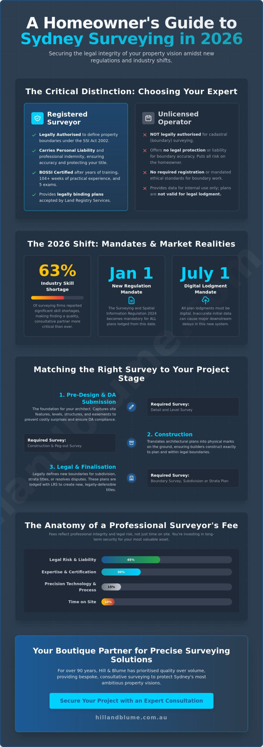
What if the invisible lines defining your Sydney estate are less certain than you believe? You have likely spent years curating your property into a sanctuary, so the thought of a boundary dispute or a delayed DA approval because of inaccurate data is understandably unsettling. Selecting the right surveyor is not merely a box to tick for council compliance. It is a foundational partnership that secures the legal integrity of your vision. With 63% of industry firms reporting significant skill shortages in 2026, finding an expert who balances technical precision with a sophisticated understanding of local requirements has never been more critical.
We recognize that the transition to the Surveying and Spatial Information Regulation 2024, which became mandatory for all plans on January 1, 2026, can feel overwhelming. This guide provides the clarity you need to move forward with confidence. You will discover how to navigate the upcoming July 1, 2026 digital lodgment mandate and understand why a bespoke approach to your survey is the only way to ensure a seamless project delivery. We outline exactly how to identify a registered professional who values quality over volume, protecting your investment and your peace of mind for years to come.
Key Takeaways
- Understand why only a registered surveyor is legally authorised to define your property boundaries under the Surveying and Spatial Information Act 2002.
- Learn to distinguish between commodity and consultative surveying to ensure your project receives the bespoke attention it deserves.
- Discover how matching the correct survey type to your specific project stage can eliminate common DA submission delays.
- Gain clarity on 2026 pricing structures, where fees reflect professional integrity and legal risk rather than simple time on site.
- Explore the value of a boutique partnership that prioritises your property’s long-term success over high-volume turnover.
What is a Registered Surveyor and Why is Their Role Critical in NSW?
In New South Wales, the title of Registered Surveyor represents a standard of precision that is protected by law. Under the Surveying and Spatial Information Act 2002 (NSW), these professionals are the only individuals authorised to perform cadastral surveying. This specific branch of the profession involves the legal definition of property boundaries. While many consultants offer general site “measuring,” only a registered expert has the legal standing to define exactly where your land ends and your neighbour’s begins. Hill & Blume has served as a benchmark for this professional integrity in Sydney for over 90 years. We understand that a boundary is not just a line on a map; it is a legal reality that protects your most valuable asset. To understand the broader context of what is surveying, one must look at how it bridges the gap between physical land and legal ownership.
The distinction between general measuring and cadastral work is profound. A non-registered person can provide data for internal layouts, but they cannot legally certify a boundary. This certification is mandatory for any document lodged with Land Registry Services. Without the seal of a registered professional, your subdivision plans or strata titles simply won’t be accepted. Our bespoke approach ensures that every project is anchored by this traditional integrity, providing a seamless transition from initial site visit to final lodgment.
The Legal Weight of a Surveyor’s Signature
A signature from a registered professional provides what is known as “indefeasibility of title.” This principle ensures that once your boundaries are correctly recorded, your ownership is protected against most claims. It is a shield for property owners. Because the surveyor carries significant personal liability for the accuracy of their work, this protection is well worth the professional fee. Maintaining NSW registration is no small feat; it requires years of rigorous training, including a minimum of 104 weeks of practical experience and five prescribed exams administered by the Board of Surveying and Spatial Information (BOSSI). This commitment to ethics ensures that every plan we sign meets the highest standards of accuracy.
When Does a Homeowner or Developer Need a Surveyor?
Certain milestones in property ownership demand professional intervention. You might be planning a new fence, an extension, or a large-scale subdivision. In each case, early engagement is vital. We often assist in the “discovery” phase of a renovation to identify easements or encroachments that could derail a project later. Whether you are navigating a complex Sydney site or seeking peace of mind before a purchase, our Boundary Surveys in Sydney provide the clarity you need. Engaging an expert early prevents the anxiety of boundary disputes and ensures your vision is built on a solid legal foundation.
The Essential Surveying Services: Matching the Solution to Your Vision
Every architectural vision begins with a clear understanding of the land’s physical and legal constraints. Selecting a surveyor who understands this nuance is the difference between a project that flows effortlessly and one that stalls in the DA assessment phase. A one-size-fits-all approach often misses the subtle complexities of Sydney’s historic or steeply sloping sites, leading to expensive revisions. By categorising services into pre-design, construction, and legal stages, you ensure that every data point serves a specific purpose in your project’s lifecycle. The surveying profession in Australia maintains high standards to ensure that these technical solutions provide lasting value for property owners.
Our bespoke approach moves beyond simple data collection. We view each site as a unique puzzle where the intersection of terrain, existing structures, and council regulations must be perfectly aligned. This precision is particularly vital when navigating the 2026 digital lodgment mandates, where any inconsistency in the initial data can ripple through the entire construction process. Starting with the right strategy ensures that your project remains on schedule and within its legal boundaries. A critical part of this strategy is ensuring that your approved design is accurately translated to the ground through professional construction set-out, which safeguards your build against costly boundary errors from the very first peg.
Detail and Level Surveys: The Architect’s Foundation
For most Sydney renovations, a Contour and Detail Survey is the indispensable first step. This isn’t just a map; it’s a comprehensive digital twin of your property. We capture everything from precise contours and significant trees to the location of neighbouring structures and underground utilities. This level of detail is a prerequisite for any meaningful architectural design and is scrutinised by local councils during development applications. Providing accurate data at this stage eliminates the guesswork that often causes friction with planning authorities during the assessment process. For challenging terrain or expansive sites where traditional methods face limitations, advanced drone surveying for property development in Sydney can deliver millimetre-precise 3D digital twins with remarkable speed and safety.
Boundary and Identification Surveys: Protecting Your Integrity
While they sound similar, Boundary and Identification surveys serve distinct purposes. A Boundary Survey involves the physical marking of your land’s edges, which is essential before building a new fence or retaining wall. In contrast, an Identification Survey is a written report often required during property transactions. It identifies any “encroachment” surprises, such as a neighbour’s garage crossing your line or your own eaves overhanging theirs. These documents act as the insurance policy of the real estate world, protecting you from future litigation and ensuring your investment remains secure.
Strata and Subdivision: Unlocking Property Value
In high-density hubs like Crows Nest or the Sydney CBD, the complexity of title plans increases significantly. A surveyor plays a creative role here, literally defining new parcels of land or air space through sophisticated subdivision plans. This process transforms a single title into multiple assets, significantly increasing the site’s potential. If you’re looking to explore these possibilities, our A Guide to Subdivision Surveys in Sydney offers a deeper look at the 2026 regulatory landscape. To ensure your specific project requirements are met with this level of care, you might consider how a tailored consultation could clarify your next steps.
The journey concludes with the Work-as-Executed (WAE) survey, which acts as the final seal of compliance. It confirms that what was built matches what was approved, allowing for the final sign-off on your project. This end-to-end service ensures that your vision is protected from the first measurement to the final certificate.
Registered vs. Unlicensed: How to Evaluate Survey Companies in Sydney
Choosing a surveyor in Sydney often feels like a choice between two distinct worlds: the high-volume commodity firm and the boutique, consultative partner. While a commodity approach might offer a lower initial quote, it frequently treats your property as a simple data point rather than a complex legal asset. This distinction is vital because the risks of engaging an unlicensed person for boundary work are absolute. Only a Registered Land Surveyor, as defined by the Board of Surveying and Spatial Information (BOSSI), has the legal authority to perform cadastral surveys in New South Wales. Using an unregistered individual for such tasks results in legal invalidity, meaning your plans won’t be accepted by Council or Land Registry Services, potentially costing you thousands in rework and lost time.
Local knowledge is the silent safeguard of any project. Whether you are navigating the unique terrain of the Northern Beaches or the evolving landscape of the Central Coast, your surveyor must understand the specific cadastral history of the area. At Hill & Blume, we lean on a 90-year archive of Sydney data to inform our current work. This deep historical context allows us to resolve boundary discrepancies that newer, high-volume firms might miss. You aren’t just paying for a measurement; you’re investing in a seal of quality that has been refined over nearly a century.
The Checklist for Choosing Your Surveyor
- Verify Registration: Always confirm your professional appears on the official BOSSI register. This is your primary protection against professional negligence.
- Assess Local Experience: Ask how often they work in your specific LGA. Familiarity with local council quirks can save weeks in the DA process.
- Examine the Legacy: A firm’s history is a reflection of its integrity. Look for a partner who prioritises long-term property health over quick turnover.
For a more granular look at these criteria, our guide on Choosing Between Survey Companies in Sydney provides a structured framework for your decision. It ensures you select a partner who values the same level of elegance and precision you bring to your own vision.
Boutique Service vs. High-Volume Firms
The difference between a boutique agency and a high-volume firm often comes down to who handles your data. In a boutique environment, you have a dedicated project manager who understands the nuances of your site. This person isn’t just a voice in a call centre; they are a local expert committed to a depth of relationship. Curated data leads to fewer Request for Information (RFI) queries from Council because the surveyor has already anticipated potential hurdles. We prefer to focus on a few select partnerships, ensuring that every plan we produce is a polished reflection of our commitment to your project’s seamless success.
The Buying Guide: Understanding Survey Costs and Timelines in 2026
When you embark on a property journey, “how much does a surveyor cost?” is inevitably the first question you’ll ask. It’s a fair inquiry for any Sydney resident. However, a professional fee is rarely just a reflection of time spent standing on your lawn with a tripod. Instead, it is a calculation of technical complexity, historical research, and the significant legal risk the professional assumes on your behalf. In the current 2026 market, hourly rates for a qualified professional in NSW typically range from $180 to $300, reflecting the high level of expertise required to navigate modern regulations.
Several factors influence the final investment for your project. A standard boundary survey for a residential block in Sydney generally costs between $800 and $2,500. If your site features challenging terrain, dense vegetation, or requires a complex contour and detail survey on a sloping block, costs can exceed $4,000. These figures account for the bespoke nature of Sydney’s geography. Regarding timelines, you should expect a standard residential survey to take approximately two to three weeks from engagement to final delivery, though this can fluctuate based on the availability of historical records at Land Registry Services.
What Goes Into a Professional Survey Quote?
Your quote includes a vital “discovery” phase that happens long before a surveyor arrives at your gate. We spend hours searching historical records at NSW LRS to find the original survey plans that define your neighbourhood. This office-based research is often more time-consuming than the physical fieldwork. Once the measurements are captured, the data undergoes a rigorous curation process to create the final drawing. This ensures the digital plans you receive are not just accurate, but also ready for seamless integration into your architect’s workflow. From this point, a precise construction set-out in Sydney becomes the natural next step, translating those verified plans into physical reality on your site with the accuracy that modern compliance demands.
Avoiding the ‘Cheap Survey’ Trap
It’s tempting to opt for the lowest quote, but this often leads to the “cheap survey” trap. In the world of property, the most expensive survey is the one that has to be done twice. An inaccurate or non-registered survey can result in boundary disputes with neighbours, expensive redesign fees, or construction delays that far outweigh any initial savings. Investing in a Registered Surveyor provides you with a legal guarantee that protects your property’s integrity. To ensure your project starts on a foundation of absolute certainty, we invite you to request a tailored proposal for your site.
Hill & Blume: Your Boutique Partner for Precise Surveying Solutions
Choosing a surveyor is an act of trust that extends far beyond a single transaction. You aren’t simply hiring a technician to mark a line; you’re inviting a partner into the very foundation of your property vision. At Hill & Blume, we’ve spent decades refining this relationship into a seamless, polished experience that respects both your time and your investment. From the moment you receive your initial quote to the final lodgment of your plans, our process is designed to provide a sense of calm confidence. We serve as the essential seal of quality for serious property ventures across Sydney, Newcastle, and the Central Coast, ensuring that every detail is curated with care.
We believe that precision is a partnership, not just a product. This philosophy allows us to move away from the high-volume, clinical approach of larger agencies in favor of a bespoke service that values depth of relationship. When you engage with our team, you’re accessing a level of expertise that understands the human element of real estate. We recognize that behind every survey plan is a dream, a home, or a community being built, and we treat that responsibility with the professional integrity it deserves.
90 Years of Integrity and Vision
Our deep roots in these regions mean we don’t just work on the land; we understand its unique history and local nuances. With over 90 years of professional integrity as our guide, our extensive archive of local data informs every measurement we take today. This legacy is balanced with a sophisticated embrace of modern technology. We utilize high-precision drone surveying and advanced 3D modeling to ensure our bespoke approach remains at the cutting edge of the NSW property market. This marriage of traditional values and modern innovation ensures that your project is anchored by absolute accuracy and legal certainty. You can rest assured that our measurements are as enduring as our commitment to the local community.
Start Your Project with Confidence
The path to a successful development application or a secure property boundary begins with a single, considered conversation. We invite you to move beyond the uncertainty of endless searching and experience the depth of a boutique partnership that prioritizes quality over volume. You can browse our comprehensive Hill & Blume services to see how we tailor our expertise to your specific project needs. Whether you require a complex strata plan in the CBD or a precise identification survey for a coastal retreat, our team provides the clarity your project deserves. It’s time to partner with Hill & Blume for your next Sydney survey and ensure your project’s success from the very first measurement. We look forward to helping you realize your vision with precision and grace.
Building Your Property Legacy on a Foundation of Certainty
The journey of property development is defined by the precision of its first steps. As you navigate the complexities of Sydney’s landscape in 2026, the choice of a registered surveyor becomes your most strategic safeguard. You now understand that legal boundary definition requires a professional registered with BOSSI NSW to ensure your title remains indefeasible and your DA submission remains on track. You’ve also discovered how a bespoke approach prevents the hidden costs and anxieties often associated with high-volume, commodity firms.
At Hill & Blume, we believe your vision deserves a partnership anchored in traditional integrity and modern technical excellence. Our 90-year history in the Sydney region provides a depth of knowledge that newer firms simply cannot replicate. Whether you’re planning a sophisticated strata development or a private residential extension, our curated service ensures every measurement is a step toward a seamless outcome. It’s time to move forward with the calm confidence that only a trusted local expert can provide.
Secure your property’s future with a bespoke consultation from Hill & Blume. We look forward to helping you protect your investment and realize your vision with absolute precision.
Frequently Asked Questions
What is the difference between a land surveyor and a building surveyor in NSW?
A land surveyor specializes in defining property boundaries and land titles, whereas a building surveyor focuses on building code compliance and structural safety. In NSW, these are two distinct professions regulated by different boards. Our expertise as a land surveyor ensures your property’s legal footprint is accurately recorded. This provides the essential foundation for any architectural or development work you intend to pursue, preventing boundary conflicts before they arise.
How much does a boundary survey cost in Sydney for a standard residential block?
A standard boundary survey for a residential block in Sydney typically costs between $800 and $2,500 according to 2026 industry reports. This fee reflects the professional liability and the intensive historical research required to define your land title with absolute certainty. For more complex sites featuring heavy vegetation or steep slopes, the cost can range from $2,500 to over $4,000 to account for the additional technical precision required.
Do I need a new survey if I already have an old one from the previous owner?
You generally need a new survey because physical site conditions and legal requirements evolve over time. Any plan not signed before January 1, 2026, must now comply with the Surveying and Spatial Information Regulation 2024. An updated survey captures recent changes like new fences or extensions. This ensures your DA submission isn’t delayed by inaccurate or non-compliant historical data that no longer reflects the reality of your land.
How long does a typical land survey take to complete from fieldwork to final report?
A typical land survey takes approximately two to three weeks to complete from the initial site visit to the final report delivery. This timeline includes the discovery phase where we search historical records at Land Registry Services and the meticulous office-based drawing process. While fieldwork might only take a few hours, the curation of technical data ensures your project moves forward with absolute legal certainty and professional polish.
Can a surveyor help me resolve a fence dispute with my neighbour?
Yes, a Registered Surveyor is the only professional who can legally resolve a fence dispute by defining the true boundary line. We physically mark the corners of your property and provide an Identification Survey report that details any encroachments. This objective, legal document often prevents expensive litigation by providing both neighbours with a clear, indisputable record of their land rights. It’s a proactive way to maintain community harmony.
What is a ‘Registered Surveyor’ and why can’t my architect do this work?
A Registered Surveyor is a professional specifically authorized under the Surveying and Spatial Information Act 2002 to define legal boundaries. While an architect possesses the vision to design your home, they lack the cadastral qualification required to sign off on land titles. Only a registered expert can certify the plans that councils and Land Registry Services require for legal property transactions. It’s a matter of legal authority and specialized training.
Does a surveyor need to enter my neighbour’s property to complete my survey?
Yes, a surveyor may need to enter a neighbouring property to locate original survey marks or measure shared structures. Under Section 19 of the Surveying and Spatial Information Act 2002, registered professionals have a legal right of entry to perform their duties. We always aim to conduct this work with the utmost discretion and respect for your neighbour’s privacy. This ensures the data is accurate while maintaining positive local relationships.
What is a Work-as-Executed (WAE) survey and when is it required by Council?
A Work-as-Executed (WAE) survey is a final plan that shows the completed construction exactly as it sits on the land. Councils require this document to verify that your building, drainage, or infrastructure matches the approved plans before they issue an Occupation Certificate. It serves as the final seal of compliance, confirming that your project meets all structural and legal requirements. It’s the final step in securing your property’s integrity.
Disclaimer
The information provided in articles published on this website is for general informational purposes only. While we make every effort to ensure the accuracy, completeness, and timeliness of the content, the material is based on our understanding of the industry at the time of writing and may not reflect the most current developments, regulations, or standards. All opinions expressed in our articles are those of the respective authors and do not necessarily represent the official position of the website or its affiliates. The content should not be considered professional, legal or technical advice, and should not be relied upon as a substitute for consultation with qualified professionals