

What if the most sophisticated architectural vision is compromised by a single inaccurate measurement? You know that in Sydney’s intricate landscape, a design is only as resilient as the data beneath it. It’s a quiet anxiety for many: the fear of a DA rejection or a costly mid-build revision caused by a hidden easement or a miscalculated slope. A precise topographic survey for architects is the essential anchor for your creative process, transforming a site’s constraints into a canvas for excellence.
At Hill & Blume, we believe that true partnership begins with technical integrity. You deserve a foundation that accounts for every boundary and level with absolute clarity. This guide explores how a professional Detail and Level Survey secures your approval pathway in New South Wales, especially with the 2026 digital lodgement mandates now in effect. We will show you how to mitigate construction risks and ensure your design translates perfectly from the screen to the Sydney soil, providing you with the calm confidence that your project is built on a legacy of precision.
Key Takeaways
- Understand how a Detail and Level Survey acts as a digital twin of your land, ensuring your vision is grounded in physical reality from the very first sketch.
- Learn why a precise topographic survey for architects must include specific contour data and tree canopy spreads to satisfy Sydney’s rigorous planning standards.
- Discover the critical role of a Registered Surveyor’s seal in securing DA and CDC approvals while precisely calculating height limits and Floor Space Ratio.
- Identify how to mitigate the risk of costly design revisions by capturing hidden site constraints before they compromise your project’s momentum.
- Explore the benefits of partnering with a local authority to receive tailored CAD deliverables that integrate effortlessly into your architectural workflow.
What is a Topographic Survey for Architects?
Your creative vision begins long before the first shovel hits the earth. It starts with a profound understanding of the land itself. A topographic survey for architects is not merely a drawing; it’s a highly accurate 3D map that captures every nuance of a site’s physical character. By documenting both natural elements and man-made structures, this survey provides the technical clarity you need to design with confidence. In its most basic form, a Topographic map illustrates the three-dimensional quality of the earth’s surface, but for a Sydney architect, the requirements are far more granular.
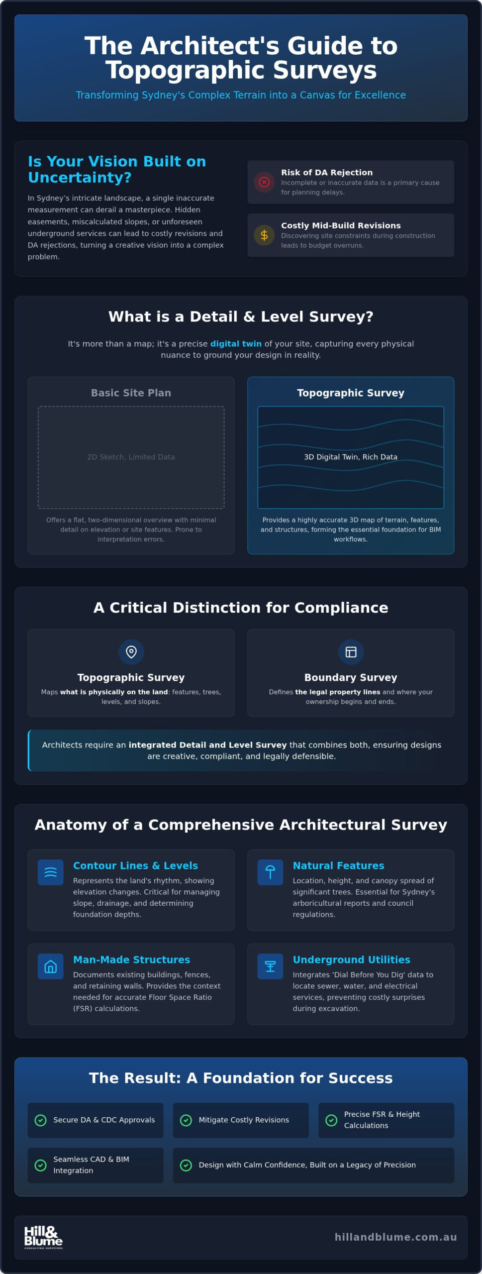
In New South Wales, you’ll often hear this essential document referred to as a Detail and Level Survey or a Contour Survey. While a basic site plan might offer a flat, two-dimensional sketch of a property, a professional topographic survey provides a digital twin of the terrain. It’s the difference between a rough estimate and a precise blueprint. This level of detail is why a topographic survey for architects remains the non-negotiable first step in any sophisticated building project, ensuring that your initial concepts are grounded in reality from day one.
The Core Purpose of Architectural Topography
The true value of a detailed survey lies in its ability to reveal what the naked eye might miss. Visualizing elevation changes is critical for managing site drainage and determining the depth of structural foundations. These levels dictate how a building sits within its environment, influencing everything from sunlight access to privacy. Beyond the visible, a survey identifies invisible constraints such as underground services and easements that could otherwise halt a project mid-construction. For modern practices, this data serves as the foundational baseline for 3D BIM (Building Information Modelling) workflows, allowing you to simulate the project’s impact with surgical precision.
The Difference Between Topographic and Boundary Surveys
It’s a common point of confusion, yet the distinction is vital for project compliance. A topographic survey focuses on what is physically present on the land, such as features, trees, and levels. In contrast, a boundary survey focuses on the legalities of where the property line exists. Because an architect must design within strict setbacks while accounting for the site’s slope, they almost always require a combined Detail and Level Survey. This integrated approach ensures that your design is not only beautiful and functional but also legally defensible and perfectly aligned with the site’s unique geometry.
Essential Data Points: What Every Architectural Survey Must Include
A topographic survey for architects acts as the definitive source of truth for your project site. It translates a physical landscape into a series of actionable data points, ensuring every line you draw is backed by empirical evidence. Beyond simple measurements, these surveys are governed by strict standards, including the Surveying and Spatial Information Regulation 2017, which establishes the precision required for legal and planning purposes in New South Wales. This technical foundation allows you to design with a calm confidence, knowing your site data is compliant and complete.
At the heart of this documentation are contour lines. These represent the rhythm of the land, showing you exactly how the terrain rises and falls across the site. For an architect, this is the primary tool for managing slope gradients and site drainage. We also document natural features with high specificity. This includes the location, height, and canopy spread of significant trees. In Sydney, these details are crucial for arboricultural reports, as council regulations often protect specific species that can dictate your building footprint. We capture existing man-made structures, fences, and retaining walls with equal care, providing the context needed for accurate Floor Space Ratio (FSR) calculations.
Underground Utilities and Services
Designing without a clear picture of what lies beneath the surface is a risk you don’t need to take. We integrate ‘Dial Before You Dig’ (DBYD) data into our topographic mapping to locate sewer mains, water pipes, and electrical conduits. This process is about more than just avoiding damage during excavation. By providing accurate invert levels, we give you the data needed for sophisticated drainage design, ensuring your project handles stormwater with elegance. This level of detail in a topographic survey for architects prevents the costly mid-project redesigns that occur when hidden services are discovered too late.
Sydney-Specific Environmental Data
Our local landscape presents unique challenges that generic surveys often overlook. Sydney’s famous sandstone outcrops are a prime example. Mapping these rock formations early allows you to estimate excavation costs more accurately and adjust your structural design accordingly. We also capture the floor levels of adjacent properties and their precise setbacks. This data is indispensable for privacy and overshadowing analysis, helping you navigate the delicate balance between a client’s vision and the community’s amenity while referencing the Australian Height Datum (AHD) for flood compliance.
Whether you are working on a coastal lot with specific hazard zones or a steep suburban block, the right data makes the difference between a seamless approval and a frustrating revision. If you have questions about the specific requirements for your next site, we invite you to reach out for a personal consultation to ensure your project begins on firm ground.
Navigating NSW Planning: DA and CDC Requirements
Securing approval for a project in Sydney requires more than an inspired design; it demands a legally robust foundation. In our experience, councils such as the Northern Beaches or the City of Sydney frequently reject site plans that lack the formal seal of a Registered Surveyor. This isn’t merely a bureaucratic hurdle. It is a safeguard. A professional topographic survey for architects ensures that the data used to calculate Floor Space Ratio (FSR) and building height limits is beyond reproach. Because the Natural Ground Level (NGL) serves as the baseline for these critical metrics, any inaccuracy in your initial site levels can lead to a fundamental flaw in your compliance strategy.
For projects following the Complying Development Certificate (CDC) pathway, the margin for error disappears entirely. While a CDC can be issued in as little as 20 days for straightforward projects, this speed is contingent on absolute adherence to the State Environmental Planning Policy (SEPP). Your survey must prove that every boundary setback and building height fits precisely within the “black and white” criteria of the code. An accurate survey doesn’t just facilitate a faster approval; it acts as a shield against the dreaded ‘Stop Work’ orders that can occur during construction if a neighbour disputes a boundary or a height limit appears to be exceeded.
Local Environmental Plans (LEPs) and Topography
Every Sydney council operates under its own Local Environmental Plan (LEP), which dictates how topography influences development. Whether your site is zoned R2 for low density or R3 for medium density, the LEP outlines specific Maximum Building Height (MBH) regulations that are tethered to the site’s existing levels. We provide the empirical proof of compliance you need, ensuring your design respects the unique constraints of its zoning. By providing this clarity early, we help you avoid the four to nine month delays often associated with merit-based DA assessments.
The Registered Surveyor’s Role in NSW
The distinction between a general site map and a certified document lies in the legal accountability of the professional behind it. Under the Surveying and Spatial Information Act 2002, only a Registered Surveyor has the authority to certify boundary locations and site levels for planning purposes. This role is a vital intersection of topographic data and cadastral law. By engaging a specialist, you ensure that your design remains strictly within the legal limits of the lot, protecting your practice from the risks of encroachment and providing your clients with the peace of mind that their investment is secure.
Avoiding Design Disasters: The Cost of Inaccurate Site Data
The ‘Garbage In, Garbage Out’ principle is a stark reality in modern architectural practice. While sophisticated software like Revit or ArchiCAD can render stunning 3D models, those models are only as reliable as the data points they are built upon. A topographic survey for architects acts as a primary risk management tool, ensuring that your digital twin reflects the physical world with absolute fidelity. When site levels are estimated or captured using subpar methods, the resulting design is often fundamentally flawed, leading to a cascade of expensive corrections once construction begins.
Consider the common scenario of a residential driveway design. If the slope gradient is off by even a small margin, the final result may be too steep to meet council standards or, worse, physically impossible for a vehicle to traverse without bottoming out. These errors aren’t just inconvenient; they are financially devastating. Inaccurate levels frequently lead to massive ‘extras’ in excavation costs and the sudden need for unplanned retaining walls. Because Sydney’s terrain is rarely uniform, a 200mm discrepancy across a building footprint can translate into thousands of dollars in unexpected rock removal or structural fill.
Professional firms like WillsByrne Construction & Landscaping LTD recognize that precise site data is essential for avoiding these pitfalls, ensuring that structural builds and complex landscaping projects are executed with technical confidence regardless of the project’s location.
We often hear the question: ‘Why can’t I just use a drone survey?’ While aerial photogrammetry is an impressive visual tool, it lacks the terrestrial verification required for legal planning submissions. Drones often struggle to see through dense tree canopies or accurately identify the location of boundary pegs hidden in long grass. For a professional topographic survey for architects to be valid for a DA or CDC, it must be ground-truthed by a specialist who can certify the data’s precision.
Mitigating Risk for Architects and Homeowners
A certified survey provides a vital layer of protection for your professional indemnity. By relying on ‘hard’ site data from a Registered Surveyor, you shift the liability of site accuracy away from your practice. This precision also benefits the homeowner by reducing uncertainty in builder quotes. When a builder has access to exact site levels and service locations, they can provide a more accurate lump-sum price, reducing the likelihood of ‘provisional sum’ blowouts. In high-density Sydney suburbs, we often recommend Identification Surveys to ensure that new structures don’t inadvertently encroach on neighbouring titles, a mistake that is nearly impossible to fix once the concrete is poured.
The Long-Term ROI of a Precision Survey
Investing in precision early helps you avoid the ‘Sydney Sandstone Surprise’ by identifying rock outcrops that dictate your excavation strategy. It also ensures that your solar access and overshadowing analyses are based on the actual heights of neighbouring structures rather than conservative estimates. This level of detail allows you to push the boundaries of a design with the confidence that it remains compliant. The investment in a professional survey represents a negligible fraction of the total project budget when compared to the catastrophic financial risks of unverified site data. If you’re ready to secure your project’s foundation, speak with our team today about your specific site requirements.
Partnering with Hill & Blume for Architectural Precision
A legacy of precision isn’t built overnight. Since 1932, Hill & Blume has been an integral part of the Sydney landscape, providing the technical foundation for some of the city’s most considered developments. We understand that a topographic survey for architects is more than just a dataset; it’s a promise of accuracy that protects your reputation and your client’s investment. By choosing a boutique firm with over 90 years of local experience, you gain a partner who understands the specific geological and regulatory quirks of our region, from the sandstone ridges of the east to the heritage conservation areas of the inner west.
We pride ourselves on a hand-crafted approach to every project. You won’t be passed between junior administrators or clinical corporate departments. Instead, you’ll have direct access to our Registered Surveyors, ensuring that the nuances of your brief are translated perfectly into our deliverables. Whether you require 3D CAD files for a complex BIM workflow or high-resolution PDFs for a planning submission, our data is tailored to integrate seamlessly into your existing architectural process. Our commitment is to provide a service that feels premium yet inclusive, reflecting the high-end quality of the homes and buildings you design.
Our Specialized Services for Architects
Our relationship with your project doesn’t end once the initial site levels are captured. We offer a suite of services designed to support you through every stage of the development lifecycle. This includes:
- Construction Set-out: Bringing your digital vision to life on the physical site with absolute precision.
- Work-as-Executed (WAE) Surveys: Providing the final, certified documentation required for council sign-off and Occupation Certificates.
- Heritage and Environmental Analysis: Delivering highly detailed site mapping for projects in sensitive zones where every centimetre of impact is scrutinized.
How to Get Started with Your Sydney Project
Starting a collaboration with us is a deliberate and considered process. We begin with a consultation to define the exact scope of your Detail and Level Survey, ensuring we capture the specific data points your design requires. To provide you with a tailored proposal, we simply need the property address and a brief overview of your architectural goals. This allows us to assess the site’s complexity and provide a timeline that respects your project’s momentum. We invite you to contact Hill & Blume today to secure the technical foundation of your next project and experience the calm confidence that comes from working with true specialists.
Securing Your Architectural Vision
Your design deserves a foundation as precise as your vision. We’ve explored how a professional topographic survey for architects transforms a site’s hidden constraints into a clear, technical roadmap for success. By capturing every contour and boundary with absolute fidelity, you ensure your DA or CDC submission is not just compliant, but bulletproof. This level of detail protects your practice from the risks of inaccurate data while providing your clients with the assurance of a seamless construction journey.
Since 1932, Hill & Blume has served as a trusted partner to the Sydney architectural community. As Registered NSW Land Surveyors, we bring nearly a century of expertise to every site, navigating the intricate requirements of local councils with a boutique, personalized touch. We invite you to Request a Precision Detail and Level Survey Quote today to begin your next project on firm ground. We look forward to helping you translate your most ambitious concepts into a physical reality that stands the test of time.
Architectural Surveying: Frequently Asked Questions
What is the difference between a contour survey and a topographic survey?
In the Sydney market, these terms are frequently used to describe the same essential service. A contour survey focuses specifically on the land’s elevation and slope, while a topographic survey for architects provides a more comprehensive view, including significant trees, man-made structures, and easements. We generally refer to this complete package as a Detail and Level Survey, which acts as the gold standard for your planning submissions.
How much does a topographic survey cost for a standard residential block in Sydney?
Every site in our city is unique, so pricing is determined by the complexity of the terrain and the density of existing features. Factors such as steep slopes, heavy vegetation, or the presence of significant sandstone outcrops will influence the time required on-site. We recommend requesting a customized proposal to ensure the scope perfectly aligns with your project’s specific architectural requirements and council expectations.
How long does it take to complete a topographic survey for an architect?
You can typically expect to receive your final CAD and PDF deliverables within one to two weeks following our site visit. This timeframe allows our team to conduct a meticulous ground survey and perform the necessary office-based data processing. We understand that project momentum is vital; we prioritize a steady and deliberate workflow to ensure your design remains on schedule without compromising on accuracy.
Do I need a topographic survey for a simple home extension?
Yes, a professional topographic survey for architects is almost always a mandatory requirement for any development application or complying development certificate. Even for a minor extension, your local council needs to verify that the proposed work respects boundary setbacks and height limits. Starting with accurate data prevents the frustration of a rejected application or expensive design revisions later in the process.
Can an architect perform their own topographic survey using a laser level?
While a laser level is a helpful tool for initial conceptualizing, it cannot replace a certified survey. Only a Registered Surveyor has the legal authority in New South Wales to certify boundary locations and site levels for council approval. Using unverified data for a formal submission risks significant legal and financial consequences if the building is found to encroach on a neighbour’s property or exceed height restrictions.
Will a topographic survey show the location of underground pipes and cables?
We can include the location of major underground services by integrating Dial Before You Dig (DBYD) data into your site map. This is a critical step for architects who need to design around existing sewer mains or electrical conduits. For projects requiring absolute precision, we can also provide invert levels to ensure your drainage design is technically sound and compliant with Sydney’s water management standards.
Why do Sydney councils require a survey from a Registered Surveyor?
Councils require this certification to ensure that every measurement is legally defensible and adheres to the Surveying and Spatial Information Act 2002. A Registered Surveyor carries the professional indemnity and technical expertise to guarantee that your design is built on a foundation of truth. This requirement protects the community’s interests and ensures that new developments respect existing property rights and local environmental plans.
How often should a topographic survey be updated for a multi-stage project?
A survey is generally considered a snapshot of the site at a specific moment in time. If significant excavation or landscaping has occurred since the original survey was completed, an update is essential to reflect the new ground levels. It’s also important to stay mindful of regulatory shifts, such as the introduction of the Surveying and Spatial Information Regulation 2024, which may impact how your data must be presented for final sign-off.
Disclaimer
The information provided in articles published on this website is for general informational purposes only. While we make every effort to ensure the accuracy, completeness, and timeliness of the content, the material is based on our understanding of the industry at the time of writing and may not reflect the most current developments, regulations, or standards. All opinions expressed in our articles are those of the respective authors and do not necessarily represent the official position of the website or its affiliates. The content should not be considered professional, legal or technical advice, and should not be relied upon as a substitute for consultation with qualified professionals