

Imagine standing on your sun-drenched balcony in Avalon, only to receive a council notice stating your proposed extension sits three centimetres over a boundary that hasn’t been formally checked since 1974. It’s a stressful reality for many homeowners who realize too late that the peninsula’s rugged beauty requires the expert eye of land surveyors northern beaches residents can trust. You likely believe that your property’s future deserves more than a “near enough” estimate; it requires the precision that only comes from 90 years of Sydney heritage.
At Hill & Blume, we’re here to ensure your project moves from vision to reality without the friction of DA rejections or neighbor disputes. This guide shares how to navigate the unique challenges of steep coastal terrain and the specific 2026 regulatory requirements of the Northern Beaches Council. You’ll gain a clear roadmap for a seamless approval process and learn why a bespoke approach to site data is the most valuable investment you’ll make in your coastal lifestyle.
Key Takeaways
- Understand how the unique geography of the coastline, from sandy plains to steep escarpments, demands specialized surveying techniques for a stable project foundation.
- Discover why a bespoke Detail and Level survey is the essential first step for achieving architectural excellence and navigating complex coastal terrain.
- Learn to master the nuances of the Northern Beaches Council LEP and critical planning overlays, including bushfire and flooding requirements, for seamless compliance.
- Identify the vital importance of engaging registered land surveyors northern beaches to ensure all legal plans meet BOSSI standards and resolve boundary uncertainties with confidence.
- Explore how a 90-year legacy of Sydney heritage translates into a premium partnership that values the integrity and unique vision of your property.
Understanding the Unique Terrain and Surveying Needs of the Northern Beaches
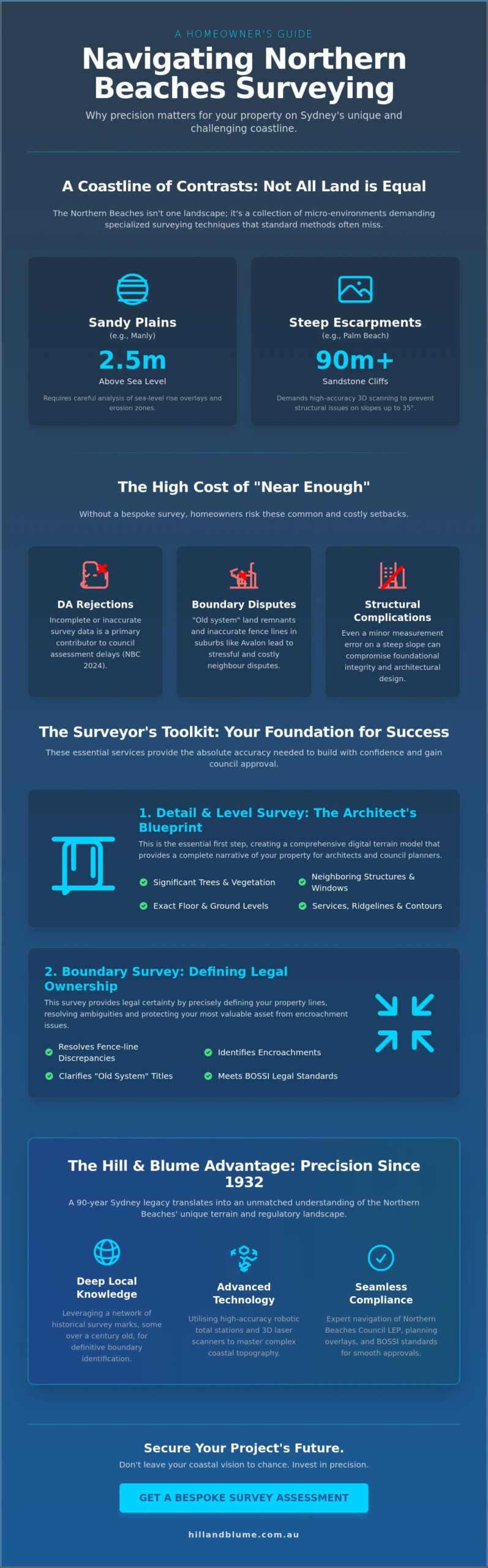
The Northern Beaches coastline stretches across 30 kilometers of diverse geography, demanding a specialized touch that respects its natural complexity. You’ll find that this region isn’t a singular landscape; it’s a collection of micro-environments. From the flat, sandy plains of Manly that sit just 2.5 meters above sea level to the 90-meter sandstone escarpments of Palm Beach, the terrain shifts dramatically. This variety means a bespoke approach is essential. When you engage What is Land Surveying? as a professional discipline, you’ll see it requires a deep understanding of how these local landforms behave over time.
Standard surveying techniques often falter in these complex coastal environments. High elevation changes and the constant influence of the Pacific Ocean create a set of variables that generalist firms might miss. Integrity in measurement is vital here, especially when identifying erosion zones and 2026 sea-level rise overlays. Local land surveyors northern beaches rely on a network of historical survey marks, some dating back over a century, to define boundaries with absolute precision. These marks are the anchor of your property’s value, ensuring your investment is protected against the shifting coastal sands.
The Challenges of Coastal Topography
Managing steep site access is a hallmark of working in suburbs like Avalon or Bilgola Plateau. On a 35-degree slope, even a minor measurement error can lead to significant structural complications. Expert land surveyors northern beaches utilize high-accuracy robotic total stations and 3D laser scanners to capture nuanced contour data. This precision allows architects to design homes that hug the cliffside safely. You’ll find that a curated survey provides the exact data needed to navigate the subtle geographic shifts that define Sydney’s northern edge.
Preserving the Northern Beaches Lifestyle Through Accuracy
Accuracy isn’t just about boundaries; it’s about preserving the “leafy” and “coastal” character you love. Precise detail surveys ensure that new developments respect the privacy and sunlight of neighboring homes. By mapping every existing tree and ridgeline, we help you maintain the delicate balance between modern luxury and natural beauty. This careful planning protects the views that define your property’s worth and the community’s shared vision. A topographic survey is a detailed map of a site’s physical features, including elevation changes and existing structures, required by Northern Beaches Council to ensure new builds integrate seamlessly with the natural landscape.
Essential Surveying Services for Northern Beaches Property Owners
Every architectural masterpiece on the peninsula begins with a precise understanding of the land. Whether you are planning a coastal retreat in Palm Beach or a modern renovation in Freshwater, the expertise of land surveyors northern beaches ensures your vision rests on a foundation of absolute accuracy. Our region’s unique topography requires more than a cursory glance; it demands a bespoke technical analysis that respects both the environment and the legal framework of New South Wales.
Detail and Level Surveys for DA Submissions
Architects require a narrative of the terrain rather than a simple map. A high-quality detail survey captures every significant tree, neighboring structure, and exact floor level to ensure your design integrates seamlessly with its surroundings. This precision directly influences your Council DA approval timeline. In 2024, Northern Beaches Council data indicated that incomplete survey information was a primary contributor to assessment delays. By providing a comprehensive digital terrain model, you eliminate guesswork for planning officers. Understanding boundary surveys in Sydney is a critical first step toward ensuring your design respects the legal nuances of your specific site.
Boundary Surveys and Encroachment Disputes
Established suburbs like Avalon and Narrabeen often hide “old system” land remnants that complicate modern transactions. These historical discrepancies frequently lead to the “fence-line” anxieties common in older neighborhoods. Resolving these issues requires a forensic approach to land title that goes beyond modern GPS coordinates. The legal weight of a registered surveyor‘s signature is your ultimate protection in NSW boundary disputes. When Selecting a Registered Surveyor, you engage a professional bound by the Surveying and Spatial Information Act 2002. Hill & Blume utilizes a unique 90-year archive to cross-reference historical data, providing a level of integrity and clarity that helps maintain harmony between neighbors.
Property owners also require specialized documentation during the exchange process or for high-density living. Key services include:
- Identification Reports: Essential during property transfers to identify structural encroachments or non-compliance with local setbacks.
- Strata and Community Title Plans: The vital blueprints for modern apartment developments in hubs like Dee Why, defining the exact limits of private versus common property.
- Consolidation Plans: Necessary when merging multiple smaller lots into a single cohesive land title for larger residential projects.
The complexity of coastal land requires a partner who understands the local fabric of the Northern Beaches. If you are preparing to embark on a new build or need to resolve a boundary uncertainty, a bespoke approach to your surveying needs will ensure your project proceeds with confidence and grace.
Navigating Northern Beaches Council & Regulatory Compliance
Navigating the regulatory waters of the Northern Beaches requires more than technical skill; it demands a deep affinity for the local landscape. The Northern Beaches Council Local Environmental Plan (LEP) serves as the primary blueprint for development, yet its nuances are often found in the subtle intersections of geography and policy. When you partner with experienced land surveyors northern beaches, you’re investing in a bespoke strategy to manage complex planning overlays. Whether your property sits within a bushfire-prone zone in Avalon or a heritage conservation area in Manly, the survey dictates your architectural boundaries. Precise measurements of Gross Floor Area (GFA) and Building Height are not merely suggestions; they are the rigid pillars of compliance that prevent costly delays during the assessment phase.
Local knowledge of the council’s specific submission formats provides a distinct competitive advantage. It ensures that your documentation moves through the system with the grace and efficiency your project deserves. This curated approach to surveying transforms a technical requirement into a seamless bridge between your vision and the council’s expectations.
Compliance with Local Planning Overlays
The protection of our coastal canopy is a priority for the community. Surveyors must meticulously capture “Significant Trees” as defined by the council’s vegetation protection orders, ensuring that your vision respects the local ecosystem. For those building near the vibrant ecosystems of the Narrabeen or Manly lagoons, establishing the Australian Height Datum (AHD) is a non-negotiable step for flood risk management. This data allows for the accurate calculation of Floor Space Ratio (FSR), a critical metric for residential extensions that ensures your home remains harmonious with its surroundings.
The DA Process: From Site Survey to Occupation Certificate
Securing a successful Development Application (DA) relies on the clarity of your submission. Aligning your project with Northern Beaches Council’s development standards requires a surveyor who understands specific local requirements. This partnership begins with a site survey and extends through to the final Occupation Certificate. A “set-out” survey acts as your builder’s compass, ensuring every wall and footing respects legal setbacks to the millimetre. Finally, the “Work-as-Executed” (WAE) survey provides the council with the definitive proof of compliance needed for final sign-off. By integrating survey data into CAD models, land surveyors northern beaches allow architects to design with absolute confidence in the site’s physical reality.
- Bespoke Accuracy: Ensuring every boundary reflects the latest 2026 digital land registry data.
- Regulatory Integrity: Navigating heritage and bushfire overlays with sophisticated precision.
- Seamless Integration: Providing CAD-ready data that flows directly into your designer’s workflow.
Selecting a Registered Surveyor: A Checklist for Coastal Projects
Your vision for a coastal home deserves more than a standard measurement. It requires a partnership with experts who view your land with the same reverence you do. When you’re vetting land surveyors northern beaches, the distinction between a technician and a Registered Surveyor is paramount. The choice between a high-volume firm and a boutique practice is often the difference between a simple transaction and a curated relationship. You need a team that prioritizes the integrity of your site above all else. Before committing to any firm, reviewing a comprehensive checklist for evaluating survey companies in Sydney can help you identify the technical standards and compliance markers that separate a reliable partner from a costly mistake.
Precision is the hallmark of a bespoke service. In 2026, the use of 3D laser scanning and robotic total stations isn’t just a luxury; it’s a necessity for capturing the intricate contours of a cliffside lot. You should ask if a firm maintains a private archive of historical records for your specific suburb. Having access to data from past decades can often resolve boundary ambiguities that modern equipment might miss. This depth of knowledge ensures a seamless transition from the initial site visit to the final lodgement with the Northern Beaches Council.
Why “Registered” Matters
In NSW, the Board of Surveying and Spatial Information (BOSSI) governs the industry. It’s a legal requirement that only a registered surveyor in NSW signs off on plans that define property boundaries. Choosing an unlicensed individual exposes you to significant liability and potential boundary disputes. Professional indemnity insurance is a non-negotiable safeguard for your peace of mind. It ensures that your investment remains protected long after the project concludes. Registered surveyors also adhere to a strict code of ethics, ensuring every measurement is handled with absolute transparency.
Questions to Ask Your Potential Surveyor
The unique topography of the peninsula requires specialized skills. You should feel confident in your surveyor’s ability to navigate complex terrain. Consider asking these specific questions during your initial consultation:
- “How do you handle steep sites with limited visibility or dense coastal vegetation?”
- “What is your typical turnaround time for a Northern Beaches Council-compliant detail survey?”
- “Can you provide examples of similar projects you’ve completed in suburbs like Manly or Brookvale?”
A firm with local roots will answer these with ease. They’ll understand that a detail survey for a 20 degree slope in Whale Beach requires a different methodology than a flat block in Narrabeen. Most reputable firms aim for a turnaround of 10 to 15 business days, though this varies based on site complexity. By choosing a land surveyors northern beaches team with a boutique focus, you ensure a direct line to the project surveyor rather than being passed to a junior staff member. For a deeper understanding of what separates an exceptional professional from the rest, the 2026 professional buying guide for choosing a surveyor in Sydney outlines the key credentials and compliance markers to look for when making this critical decision.
Every property tells a story, and the right surveyor acts as its most accurate narrator. They translate the physical world into the legal and digital frameworks required for modern construction. This partnership is the foundation upon which your architectural dreams are built.
Explore how a bespoke approach to surveying can elevate your project.
Hill & Blume: Delivering Bespoke Surveying Solutions Since 1932
Since 1932, Hill & Blume has stood as a pillar of reliability within the Sydney property landscape. Our philosophy is simple. We blend the steadfast integrity of traditional surveying with the sharp precision of modern technology. For those searching for land surveyors northern beaches, our 90-year legacy offers a level of insight that only time can cultivate. We see every project as a partnership. It’s about more than just boundaries; it’s about providing the confidence you need to build your vision. Our bespoke approach means we value quality over high-volume turnover, ensuring every client receives a service that is as curated as it is accurate.
A Heritage of Precision
Our team leverages an extensive library of historical survey records to find the “unfindable” boundary peg. These documents are vital when working with older coastal titles where modern markers may have shifted or disappeared. We’ve watched Sydney grow and change, and that perspective is invaluable for Northern Beaches projects. Despite the industry’s shift toward cold, digital data, we’ve kept the personal touch alive. We believe in being present on-site and available for a conversation. This balance of historical wisdom and technological edge ensures your property boundaries are defined with absolute certainty.
Your Partners in Property Development
Our work spans the full spectrum of property needs, from modest residential extensions to intricate strata subdivisions. When you engage Hill & Blume as your land surveyors northern beaches, you aren’t just hiring a technician; you’re hiring a legacy of local knowledge. Our registered experts are ready to guide you through the complexities of local council requirements and coastal regulations. By starting your project with a bespoke consultation, you gain access to a team that prioritizes detail and professional excellence. We don’t just provide a map; we provide a clear path forward for your development.
Our presence in the region is more than professional. It’s a commitment to the community we serve. By choosing Hill & Blume, you’re engaging with a firm that treats your property with the same care and respect you do. We invite you to discover how our century of experience can benefit your next project. Our team is dedicated to maintaining the unique charm of the coast while ensuring every development is built on a foundation of accuracy.
Securing Your Coastal Vision with Precision and Heritage
Your property is more than a simple parcel of land; it’s the foundation of your future on the coast. Successfully navigating the unique sandstone terrain and the specific Northern Beaches Council DA requirements demands a partner who understands the local landscape’s nuances. By prioritizing BOSSI registered expertise, you ensure every boundary and contour is defined with absolute precision. Hill & Blume has delivered this level of excellence since 1932, blending over 90 years of Sydney surveying experience with a sophisticated, curated service. We focus on building lasting partnerships, ensuring your vision is supported by technical mastery and genuine local care. When you choose the right land surveyors northern beaches property owners trust, the path from initial concept to final approval becomes a seamless journey. We’ve spent decades refining a bespoke approach that respects both the environment and your aspirations. It’s about providing clarity where there’s complexity and confidence where there’s uncertainty. We invite you to experience a service where heritage meets modern innovation. Request a bespoke survey quote for your Northern Beaches property and let’s begin crafting your coastal legacy together.
Frequently Asked Questions
Do I need a survey if I am just building a new fence on the Northern Beaches?
Yes, obtaining a Boundary Identification Survey is the only way to ensure your new fence sits precisely on the legal property line. In the Northern Beaches, where coastal land values exceeded A$3,000 per square metre in the 2024 Valuer General report, a small error can lead to costly litigation. Engaging land surveyors northern beaches ensures your investment is protected and your relationships with neighbours remain harmonious.
How much does a land survey cost in the Northern Beaches region in 2026?
Property survey costs in 2026 depend on the terrain’s complexity and the specific scope of your project. While we provide bespoke quotes for every site, the 2025 Industry Benchmarking Report indicates that coastal surveys require 20 percent more field time due to complex elevations. We focus on a tailored approach that reflects the precision required for your specific site, ensuring every detail of your vision is captured with integrity.
Is a “Site Survey” the same as a “Boundary Survey” in NSW?
No, these surveys serve different purposes and are governed by the Real Property Act 1900. A Site Survey, often called a Detail and Level Survey, focuses on physical features and topography, while a Boundary Survey defines the legal limits of your land. You’ll typically need both for a renovation to ensure your project doesn’t encroach on any of the 1,200 kilometres of council easements in the region.
How long does it take to get a detail and level survey for a DA submission?
You should typically allow 10 to 15 business days for the completion of a detail and level survey for your DA submission. This timeframe accounts for the initial site visit and the meticulous drafting of the plans required by the Northern Beaches Council. Starting this process early is a seamless way to keep your development timeline on track and avoid unnecessary delays during the planning phase.
What happens if my neighbor’s garage is over my boundary line?
If a structure crosses your boundary, the first step is obtaining a formal Identification Survey to document the exact extent of the encroachment. Under the Encroachment of Buildings Act 1922, you have several avenues for resolution, including compensation or the removal of the structure. Our team acts as a trusted partner, providing the precise data you need to resolve these delicate matters with clarity and professional grace.
Can a Northern Beaches surveyor help with a strata subdivision?
Land surveyors northern beaches are vital partners in the strata subdivision process, as they prepare the detailed Strata Plans required for registration with NSW Land Registry Services. We guide you through the complexities of defining common property and individual lots. This bespoke service ensures your development meets all statutory requirements while maximizing the value and clarity of your property assets through a curated, professional experience.
Why does the Northern Beaches Council require AHD levels for my pool?
The Northern Beaches Council requires Australian Height Datum (AHD) levels to ensure your pool design manages water runoff and flood risks effectively. According to the Council’s 2023 Water Management Policy, precise elevation data is mandatory for any structure that might alter natural drainage patterns. Providing these levels ensures your outdoor oasis is both beautiful and compliant with local environmental safeguards that protect our coastal community.
Is a drone survey accurate enough for a boundary identification?
Drone surveys provide stunning visual data and topographic mapping, but they don’t meet the 10mm accuracy standard required for defining legal property boundaries in NSW. Boundary identification requires a registered surveyor to physically locate marks based on historical title records. While we embrace modern technology for its efficiency, the integrity of your property line relies on traditional ground-based measurements and the expert certification provided by Hill & Blume.
Disclaimer
The information provided in articles published on this website is for general informational purposes only. While we make every effort to ensure the accuracy, completeness, and timeliness of the content, the material is based on our understanding of the industry at the time of writing and may not reflect the most current developments, regulations, or standards. All opinions expressed in our articles are those of the respective authors and do not necessarily represent the official position of the website or its affiliates. The content should not be considered professional, legal or technical advice, and should not be relied upon as a substitute for consultation with qualified professionals