

What if the fence line you have mowed beside for years isn’t actually where your land ends? It’s a question that keeps many homeowners awake at night, especially when digital maps or neighborly assumptions start to clash with reality. Understanding legal property boundaries in NSW is about more than just peace of mind; it’s about protecting the integrity of your most significant asset. While a garden bed or a timber palisade might feel like a permanent marker, the legal truth is often hidden in the state’s cadastre, far beyond what the naked eye can see.
You likely already know that property disputes can be both emotionally draining and financially taxing. It’s natural to feel a sense of unease when you’re unsure if a new deck or extension might accidentally cross a line. This guide promises to clarify those complexities, showing you how to secure your land’s legal footprint with precision and confidence. We will examine the crucial distinction between a fence and a boundary, discuss the impact of the latest digital mandates for survey plans, and explain exactly when you should engage a registered professional to define your space once and for all.
Key Takeaways
- Realise that the official state register is the ultimate authority on your land, as physical markers like fences don’t always reflect your true title.
- Understand why digital tools and satellite overlays are merely indicative and should never be used to verify legal property boundaries nsw.
- Learn how to identify subtle encroachments, such as overhanging gutters or misplaced garden walls, before they evolve into complex neighbor disputes.
- Discover the rigorous survey process that blends deep historical research with precise onsite measurements to confirm your property’s legal footprint.
- Appreciate the peace of mind that comes from engaging a boutique firm with over 90 years of local expertise across Sydney and the Central Coast.
Understanding the NSW Cadastral System and Your Property Rights
Your property is more than just a physical space; it’s a legal entity defined by a complex network of records. In New South Wales, this network is known as the cadastral system. It serves as the official register of every parcel of land, ensuring that legal property boundaries nsw are clearly documented and protected. This system isn’t just a collection of maps. It’s a rigorous legal framework managed by NSW Land Registry Services (LRS), providing the certainty you need to invest in and enjoy your home.
At the heart of this framework lies the principle that “the Register is everything.” Most residential land operates under the Torrens title system, which replaced the cumbersome and often unreliable “Old System” of deeds. Under Torrens title, the state maintains a central register that acts as the single source of truth. If an interest or a boundary isn’t recorded on the title, it generally doesn’t exist in the eyes of the law. This provides a layer of security that allows you to trust the legal footprint of your land.
The Legal Significance of the Deposited Plan (DP)
Every parcel of land in NSW is identified by its Deposited Plan, or DP. Think of the DP as the DNA of your property. It’s the original survey document that shows the dimensions, bearings, and location of your land in relation to the surrounding area. A Deposited Plan is the definitive legal map of a land subdivision. Even surveys conducted 90 years ago, like those from our early days in 1932, still hold immense weight today. They provide the historical evidence needed to resolve modern discrepancies and protect your property’s legacy.
Torrens Title vs. Old System Land
While most of Sydney and Newcastle has transitioned to the modern system, small pockets of Old System land still linger. These properties require a more complex chain of title research to verify ownership. It’s also vital to remember that title insurance, while helpful, doesn’t always provide a remedy for boundary errors. It often excludes issues that a physical survey would have revealed. Understanding the registered interests on your title, such as easements for drainage or electricity, is essential for maintaining the value of your asset. You can explore our professional surveying services to ensure every detail of your title is accurately accounted for.
Digital Maps vs. Legal Reality: The Trap of “Indicative” Boundaries
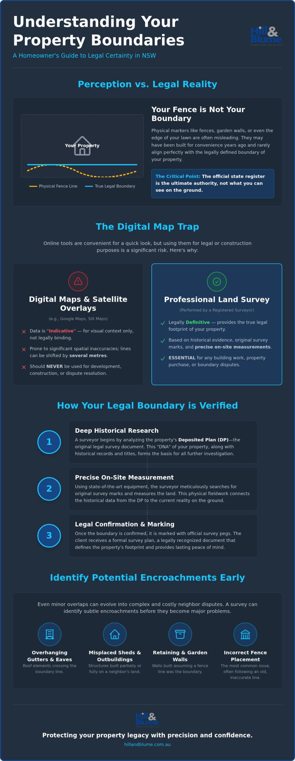
Many homeowners believe that a quick search on SIX Maps or a glance at Google Earth provides a definitive answer to where their land ends. It’s a convenient assumption, but it’s often a costly one. These digital tools are designed for visual context, not for defining legal property boundaries nsw. They rely on “indicative” data, where digital property lines are mathematically draped over satellite imagery. This process inherently creates spatial inaccuracies. A line that looks perfectly aligned on your screen might actually be shifted by several metres in the real world.
The physical reality on the ground often tells a different story than the digital overlay. A fence line, for instance, rarely matches the technical cadastral line with total precision. Fences are built by people who might have followed an old garden bed or a convenient rock formation rather than a surveyor’s peg. In the high-value landscape of Sydney and Newcastle real estate, even a few centimetres of discrepancy can lead to significant legal headaches. Relying on DIY measurements or web-based maps for property development is a risk that rarely pays off.
Why SIX Maps is Not a Survey
Digital maps are helpful for broad planning, but they lack the forensic precision of a physical survey. The data used by these portals is often “fitted” to match existing landmarks, which can lead to significant discrepancies. While the public sees a simplified view, professionals use specialized portals to access the raw, underlying cadastral data. For those planning a renovation or purchase, securing professional verification is the only way to avoid the digital trap. As per the NSW Registrar General’s boundary guidelines, the legal definition of a boundary depends on the original survey marks and historical evidence, not a digital overlay.
The Risk of Relying on “Indicative” Data
The danger of relying on indicative data becomes painfully clear during construction. Imagine building a high-value retaining wall or a boundary fence in a tight urban space, only to discover it’s thirty centimetres into your neighbor’s yard. These minor errors frequently escalate into expensive disputes in the Land and Environment Court. A fence is a physical structure, not a legal guarantee. Only a Registered Surveyor has the authority to interpret historical plans and apply them to the physical landscape. If you’re unsure about the true extent of your land, reach out to our team for a considered conversation about your property’s unique requirements.
Common Boundary Issues: Fences, Encroachments, and Easements
A fence is rarely a definitive legal boundary. While we often treat the timber or masonry structure between properties as the edge of our world, it’s frequently just a convenient approximation. In New South Wales, the Dividing Fences Act 1991 governs how neighbors share the costs and maintenance of these structures, but it doesn’t define where your land actually ends. The true legal property boundaries nsw are invisible lines determined by historical survey marks and registered plans, not by the placement of a fence post. If a fence has been built even ten centimeters off the mark, it doesn’t change your title; it simply creates a potential for conflict.
There’s a persistent myth that you can claim a neighbor’s land simply by occupying it for a long period, a concept known as adverse possession. On Torrens Title land, which accounts for the vast majority of property in Sydney and Newcastle, this is almost impossible. The state’s guarantee of title means that the registered boundary remains the legal reality regardless of how long a fence has been in the wrong place. This principle is reinforced by the Registrar General’s Guidelines on Boundary Definition, which prioritize recorded survey evidence over physical occupation. Understanding this distinction is the first step in protecting your property’s integrity.
Dealing with Encroachments and Overhangs
Encroachment occurs when a structure, such as a garage wall, a garden shed, or even overhanging eaves and gutters, crosses the cadastral line onto an adjoining property. These issues often surface during a pre-purchase inspection or when you’re planning a new build. Resolving an encroachment might involve a legal “redefinition” of the boundary or a formal agreement between neighbors. If you’re concerned about a structure’s position, our guide to Boundary Surveys in Sydney provides a deeper look at how we identify these physical overlaps with surgical precision.
Easements and Rights of Way
You might own the land, but you don’t always have the exclusive right to use every square inch of it. Easements for drainage, electricity, or shared driveways are common across NSW and can significantly restrict where you’re allowed to build. A digital map might show a general area, but it often misses “unregistered” easements or the exact dimensions of a right of way. A professional survey identifies these hidden restrictions, ensuring you don’t accidentally build a permanent structure over a vital utility line. You can find more information about identifying these restrictions through our specialized surveying services.
How to Legally Verify Your Boundaries: The Survey Process
Verifying your property’s true extent is a meticulous process that bridges the gap between historical records and the physical earth. It’s a journey of discovery that ensures your legal property boundaries nsw are beyond reproach. This isn’t a matter of simple tape measurements; it’s a forensic investigation that follows five distinct stages to provide the certainty you deserve. When you engage a professional, you’re investing in a legacy of precision that protects your home for decades to come.
- Step 1: Historical Research. We delve into the archives of the NSW Land Registry Services, examining the original Deposited Plan and any surrounding surveys. Our firm’s records, which date back to 1932, often provide a unique perspective on these historical layers.
- Step 2: Fieldwork. Our surveyors arrive on-site to locate physical evidence. This includes original survey marks, existing fences, and the corners of permanent structures that help anchor the land’s position.
- Step 3: Mathematical Reduction. Back in the office, we perform rigorous calculations to compare our field measurements against the legal record. This identifies any discrepancies between the physical fence and the cadastral line.
- Step 4: Re-marking. If required, we place fresh boundary pegs to give you a visible, tangible understanding of your land’s edge.
- Step 5: Reporting. We synthesize all findings into a formal Identification Survey Report.
The Identification Survey Report
This document is a seal of quality that provides a detailed snapshot of your property’s legal standing. It highlights whether structures like eaves or garages encroach on neighboring land and confirms the position of fences relative to the boundary. Banks and solicitors require this report during property transfers to mitigate risk and ensure the title is clean. Only a Registered Surveyor has the legal authority to sign these documents, providing the weight of professional liability and expertise. You can view our full range of surveying services to see which report best suits your specific project.
When is a New Plan of Survey Required?
There are times when a simple report isn’t enough. If you’re subdividing a lot, consolidating titles, or embarking on a major strata development, you must lodge a new plan of survey with the NSW LRS. This process effectively retires the old records and updates the state’s cadastre. A new plan of survey creates a fresh legal identity for your land, ensuring your legal property boundaries nsw are perfectly aligned with modern standards. If you’re preparing for a renovation or a sale, reach out to our expert team to begin the verification process with a considered consultation.
Protecting Your Property Legacy with Hill & Blume
Your home is likely your most significant investment. It’s a legacy you pass down or a foundation for your future aspirations. While the legalities of the cadastral system can feel clinical, the protection of your legal property boundaries nsw is a deeply personal matter. Choosing a surveyor isn’t just about ticking a regulatory box; it’s about finding a professional steward for your property’s integrity. At Hill & Blume, we view our work as a partnership. We provide a boutique experience that prioritizes the depth of our relationship with you over the high-volume turnover seen in larger, more clinical agencies.
Unlike corporate entities that focus on speed, our boutique model allows for a meticulous, hand-crafted approach to every boundary identification. This precision is the ultimate safeguard against future litigation or construction errors. Think of a professional survey as an essential insurance policy for your home renovation. It’s the only way to be certain that every dollar you spend on a new extension or landscaping is anchored on land that is legally and indisputably yours. We offer the peace of mind that comes from knowing your boundaries are defined by experts who value quality over quantity.
A Tradition of Precision Since 1932
Established in 1932, our firm has witnessed the evolution of Sydney and the Central Coast first-hand. This 90-year history isn’t just a number; it’s a vast archive of local knowledge that allows us to interpret complex historical plans with a level of insight that newer firms often lack. We combine this traditional integrity with modern laser scanning and digital mapping technology. This dual approach allows us to support architects and developers with data that is both technically compliant and contextually accurate. Our partnership-oriented narrative ensures that you’re never just another file number, but a valued client receiving a curated experience.
Your Next Steps for Boundary Certainty
Gaining certainty over your property’s footprint is a straightforward but essential step for any homeowner. When you’re ready to move forward, requesting a tailored quote for your specific site is the best way to begin. To help us provide the most accurate assessment, it’s useful to have your title details or a previous Deposited Plan number ready. We also consider site access and the unique requirements of your project, whether you’re resolving a minor fence discrepancy or preparing for a major subdivision. Our team is here to guide you through the process with calm confidence and professional care.
Secure your property boundaries with Hill & Blume’s expert surveyors today.
Establishing Certainty for Your Home
Your property is more than a parcel of land; it’s a sanctuary and a significant financial legacy. Relying on digital overlays or the position of an old fence often leads to unforeseen complications. True peace of mind comes from knowing exactly where your land starts and ends. By verifying your legal property boundaries nsw, you protect yourself from the risks of encroachment and ensure that every future renovation is built on a foundation of legal accuracy.
At Hill & Blume, we bring over 90 years of Sydney surveying expertise to every project. Our team of Registered NSW Surveyors specializes in complex boundary identification, offering a boutique service that respects the unique character of your neighborhood. Whether you’re planning a subdivision or simply seeking clarity before a new build, we provide the professional stewardship your property deserves. Request a Professional Boundary Consultation with our specialists today to anchor your property’s future in precision. We look forward to helping you secure your land with confidence and care.
Frequently Asked Questions
Is a fence always the legal boundary in NSW?
A fence is rarely the definitive legal line. While it provides a physical marker, the true legal property boundaries nsw are defined by the state’s cadastral records and original survey marks. In older Sydney suburbs, fences often deviate from the title due to decades of shifting soil or amateur construction. Relying on a timber fence for a new extension can lead to costly encroachment disputes that the Dividing Fences Act won’t resolve.
What is the difference between an Identification Survey and a Boundary Survey?
An Identification Survey focuses on the relationship between physical structures and the boundary, which is why they’re essential for property transfers. A Boundary Survey is more about re-establishing the actual corners of the land. Both require a Registered Surveyor to interpret historical plans. If you’re building a new wall, you need the precision of boundary marking. If you’re buying a home in Newcastle, an ID survey confirms you’re actually getting what you’re paying for.
Can I find my property boundaries for free online?
Free digital tools like SIX Maps provide helpful visual context, but they aren’t legally accurate. These maps use “indicative” overlays that can be out by several metres. They don’t account for the complex historical evidence required to define legal property boundaries nsw. For a project on the Central Coast, relying on a free web map is a high-risk strategy. Professional fieldwork is the only way to confirm your land’s true footprint with surgical precision.
What should I do if I think my neighbour is encroaching on my land?
Your first step should always be to confirm the boundary with a professional survey to avoid making false accusations. If the survey proves an encroachment, such as a garage or eaves crossing the line, you should seek legal advice or engage in neighborly mediation. Many disputes in Sydney are resolved through a formal boundary redefinition or an easement. Avoid taking physical action yourself, as this can escalate the conflict into the Land and Environment Court.
How long does a boundary survey take to complete in Sydney?
Most residential surveys in the Sydney region take between five and ten business days to complete from start to finish. This timeframe includes the essential historical research at the Land Registry Services and the physical fieldwork on your site. Complex properties in older areas might require additional time for forensic analysis of 90-year-old records. We prioritize accuracy over speed to ensure the data we provide stands up to any legal scrutiny.
Does a boundary survey expire in NSW?
A survey report doesn’t have a formal expiration date, but its relevance can fade as the physical landscape changes. Boundary pegs can be moved by landscaping, and new structures on neighboring lots can create fresh encroachment risks. If you’re planning a significant renovation or sale, it’s wise to have a Registered Surveyor verify that the previous findings are still accurate. This ensures your property records reflect the current reality of the land.
What is a “Registered Surveyor” and why do I need one?
A Registered Surveyor is a professional who has met the rigorous training and ethical standards set by the Board of Surveying and Spatial Information (BOSSI). They are the only individuals legally empowered to define land boundaries in New South Wales. Engaging a registered professional ensures that your survey is backed by professional indemnity insurance and a deep understanding of property law. It’s a seal of quality that protects your most valuable asset from technical errors.
Will title insurance cover a boundary dispute?
Title insurance might provide coverage for certain boundary discrepancies, but it’s not a universal shield. Many policies specifically exclude issues that would have been revealed by a physical survey conducted prior to purchase. It’s essential to read your Product Disclosure Statement carefully. In our experience across the Central Coast and Sydney, a proactive Identification Survey is a far more reliable way to prevent disputes than relying on an insurance claim after a conflict has already begun.
Disclaimer
The information provided in articles published on this website is for general informational purposes only. While we make every effort to ensure the accuracy, completeness, and timeliness of the content, the material is based on our understanding of the industry at the time of writing and may not reflect the most current developments, regulations, or standards. All opinions expressed in our articles are those of the respective authors and do not necessarily represent the official position of the website or its affiliates. The content should not be considered professional, legal or technical advice, and should not be relied upon as a substitute for consultation with qualified professionals