
What if the most critical document in your property portfolio is the one you currently find impossible to decipher? You’ve likely stared at that crisp sheet of paper, tracing lines that don’t seem to match your garden fence and feeling a mounting sense of confusion over cryptic numbers. Learning how to read a boundary survey plan shouldn’t feel like learning a forgotten language, yet the technical bearings and legal notations often feel designed to keep homeowners at a distance. We understand that your home is more than just an asset; it’s a sanctuary that deserves the highest level of care and precision.
It’s natural to feel a flicker of anxiety when you can’t quite reconcile a physical boundary with a legal one. This guide is designed to hand you the keys to your property’s technical narrative, allowing you to master the symbols and measurements that define your land. By the end of this article, you’ll be able to interpret boundary dimensions with confidence, verify the legal validity of your document under the Surveying and Spatial Information Regulation 2017, and communicate with your architect or builder with ease. We’ll explore the nuances of Deposited Plans, demystify those complex bearings, and ensure you feel like the true authority on your own soil.
Key Takeaways
- Distinguish between the physical occupation of your land and its true legal limits to ensure your property’s integrity remains protected.
- Gain confidence in how to read a boundary survey plan by mastering the technical bearings and distance measurements that define your property lines.
- Identify the physical markers, from pegs to drill holes, that serve as the tangible anchors for your land’s legal narrative.
- Understand the significance of your Lot and Deposited Plan numbers, which function as the unique DNA for your property in the NSW land system.
- Verify the legal validity of your survey through a registered surveyor’s signature, ensuring your investment is grounded in professional precision.
Decoding the Basics of Your Boundary Survey Plan
A boundary survey plan is far more than a simple drawing of your land; it’s a precise legal instrument that serves as the definitive record of your property’s footprint. When you look at this document, you’re viewing a meticulously crafted representation of your rights as a landowner in New South Wales. Understanding how to read a boundary survey plan is the first step in protecting your investment, whether you’re planning a renovation or resolving a quiet dispute with a neighbor. At Hill & Blume, we view ourselves as guardians of property integrity. With a legacy stretching back to 1932, we understand that every millimetre matters when it comes to the legal limits of your home.
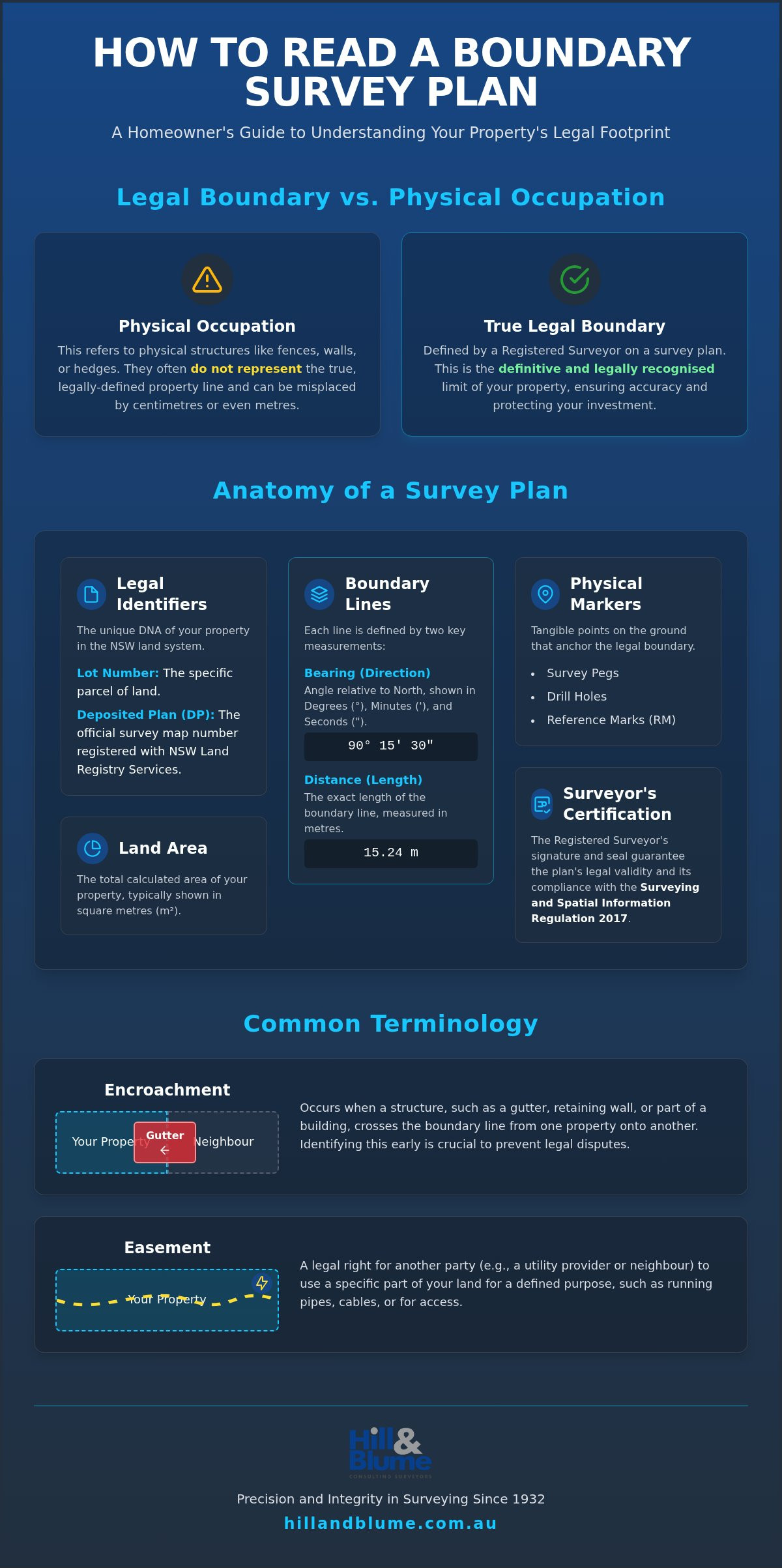
The primary purpose of this plan is to distinguish between the legal limits of your land and the physical occupation currently on site. It’s a common misconception that a fence line dictates where your property ends. In reality, fences are often misplaced by centimetres or even metres. A registered surveyor in NSW is the only professional authorized to determine these boundaries with legal certainty. Their seal on your plan isn’t just a formality; it’s a guarantee that the measurements comply with the Surveying and Spatial Information Regulation 2017, providing you with a sense of calm confidence in your property’s value.
The Difference Between a Sketch and a Registered Plan
It’s easy to mistake a real estate marketing map or a hand-drawn sketch for a formal survey, but the difference is profound. A registered plan is a technical document lodged with the NSW Land Registry Services, forming part of the state’s official land title system. This level of precision is vital during a Sydney property development. Without a registered plan, you risk building over a boundary line, which can lead to costly legal battles or the forced removal of structures. Our boutique approach ensures that these documents are handled with the care and depth of relationship your project deserves.
Common Terminology You Will Encounter
As you study your plan, you’ll encounter specific terms that define your land’s status. Cadastral surveying is the specialized discipline used to establish these legal boundaries for property purposes. You might also notice notes regarding an encroachment, which occurs when a structure, like a gutter or a retaining wall, crosses the boundary line from one property to another. Additionally, your plan will highlight easements. These are specific areas of your land where others, such as utility providers, have the right to access or use the space for a defined purpose. Recognizing these terms as you learn how to read a boundary survey plan ensures you’re never caught off guard by hidden restrictions on your sanctuary.
Understanding Bearings, Distances, and Land Area
Once you look past the initial complexity of a survey plan, you’ll notice a series of bold numbers following the perimeter of your property. These figures represent the two most vital pieces of data on the page: the distance and the bearing. In New South Wales, distances are almost exclusively recorded in metres and decimals of a metre. If you see a notation like 15.24, it means that specific boundary line is exactly fifteen metres and twenty-four centimetres long. This level of precision is the hallmark of a professional survey, ensuring that every centimetre of your sanctuary is accounted for with absolute clarity.
While the distance tells you how long a boundary is, the bearing tells you exactly where it points. These are written in a specific format: degrees (°), minutes (‘), and seconds (“). For example, a bearing might read 90° 15’ 30”. This isn’t just technical jargon; it’s the directional code that allows a surveyor to recreate your property lines on the ground with surgical accuracy. Understanding how to read a boundary survey plan requires viewing these numbers as a pair. Together, they define the unique geometry of your land, providing a level of certainty that a simple fence line can never offer.
How to Read Bearings (The Directional Code)
Bearings are always relative to North, though the specific type of North (such as True North or Map Grid of Australia) will be noted on the plan. In the world of surveying, a bearing of 00° 00′ 00″ points directly North. Unlike a handheld compass that can be affected by local magnetic interference, these bearings are fixed mathematical values governed by the NSW Registrar General’s Guidelines. This rigour ensures that even if a fence is moved or a landmark is lost, the true direction of your boundary remains legally preserved and easily recoverable by a professional.
Calculating and Verifying Land Area
The total land area is typically found in the centre of the lot or within a dedicated table on the plan, expressed in square metres (m²) or hectares for larger estates. It’s quite common to find that the area on a modern survey differs slightly from what’s written on an older title deed. This usually happens because modern technology, like the GPS and laser equipment we use at Hill & Blume, is far more precise than the chains and tapes used decades ago. Having an accurate area calculation is essential for Council DA submissions in Sydney, where even a small discrepancy can impact your building entitlements. If you’re unsure about the dimensions shown on your current documents, you might find it helpful to speak with our team for a detailed clarification of your property’s true footprint.
Identifying Physical Markers and ‘Occupation’ on the Plan
Stepping away from the abstract numbers and onto your actual lawn is where the true value of a survey becomes clear. On your plan, you’ll see a distinction between the ‘Boundary’ and the ‘Occupation’. While the boundary is an invisible legal line, occupation refers to the physical structures currently existing on the land, such as fences, retaining walls, or even the edge of a garden bed. Understanding how to read a boundary survey plan requires you to look for the relationship between these two elements. It’s quite common for a fence to sit slightly to the left or right of the true legal line, a detail that can have significant implications for your property rights and future landscaping projects.
To bridge the gap between the paper and the soil, surveyors use a curated set of symbols to represent physical markers. You might see notations for timber pegs, G.I. (galvanised iron) pipes, or drill holes and wings in concrete. These aren’t just random marks; they’re the physical evidence of your land’s history. The expertise required to set these marks is governed by professional bodies like the Association of Public Authority Surveyors (APAS), ensuring that every point is placed according to strict NSW standards. At Hill & Blume, we take pride in the craftsmanship of our on-site work, ensuring that the physical anchors of your property are as enduring as the legal records they represent.
The Language of Survey Marks
On your plan, a ‘found’ mark indicates a piece of survey evidence that existed before we arrived, such as an old iron pipe from a 1950s subdivision. A ‘placed’ mark is one that your registered surveyor has newly installed to define a corner or a line. These reference marks are essential for re-establishing boundaries if a fence is ever removed. It’s a fundamental rule of land ownership: never move or disturb a survey peg. Doing so can complicate future surveys and potentially lead to legal friction with neighbours.
Reading Occupation and Encroachments
Occupation is the term surveyors use to describe anything currently situated on or near those legal lines. If a neighbour’s garage eaves are 20mm over your line, your plan will note this as an encroachment. Surveyors often use small arrows to indicate which side of a fence the true boundary sits. If the arrow points toward your house, the fence is technically on your land. Recognising these nuances through Boundary Surveys in Sydney is the most effective way to resolve fence disputes before they escalate. It provides a clear, objective foundation for a considered conversation with your neighbours, grounded in professional fact rather than guesswork.
Navigating NSW Legal Identifiers: Lot, DP, and Surveyor Signatures
Your property is more than a street address; it’s a specific coordinate in the vast landscape of New South Wales. To truly master how to read a boundary survey plan, you must look beyond the lines and into the legal identifiers that index your land within the state system. The most critical of these are the Lot and Deposited Plan (DP) numbers. Think of the DP as the DNA of your land. It’s the official map registered with the NSW Land Registry Services that defines how your block was originally carved out from the surrounding area. Without these numbers, a plan is merely a drawing; with them, it becomes a binding legal record that tethers your property to the local fabric.
Another essential element is the North Point. You’ll notice it’s not always a simple arrow. Surveyors distinguish between Magnetic North, True North, and Grid North (MGA). Most modern plans use Grid North, which aligns with the Map Grid of Australia. This ensures that your property’s orientation is consistent with every other surveyed parcel in the country. This level of standardisation is what allows for the seamless integration of your land into the broader community, providing you with a sense of calm confidence in the accuracy of your boundaries.
The most vital mark on the entire document is the Surveyor’s Certificate. This is where the Registered Surveyor signs their name to verify that the plan is accurate and complies with the Surveying and Spatial Information Regulation 2017. This signature is your ultimate protection. It transforms a technical sheet into a legal document that can be used in court or for council approvals. At Hill & Blume, this signature represents over 90 years of integrity and a commitment to the highest standards of our craft, acting as a seal of quality for your investment.
Understanding the DP (Deposited Plan)
You’ll find the DP number prominently displayed in the title block, usually in the bottom right corner. If you’re looking at a historical plan, you might notice measurements in ‘links’ or ‘feet and inches’. A Registered Surveyor in NSW is trained to convert these old-world units into modern metres with perfect precision. These legacy plans are the foundation of Sydney’s older suburbs, and interpreting them correctly requires a deep understanding of local surveying history and a discerning eye for detail.
The Title Block and Scale
Learning how to read a boundary survey plan involves more than just looking at the drawing; it’s about understanding the context provided in the title block. This area contains the date of the survey, the scale, and a unique reference number. Pay close attention to the date. Land can shift, and new easements may be registered, making an old survey less reliable for current projects. The scale bar allows you to measure distances manually, but remember that a printed plan might not be to scale if it’s been resized. For absolute certainty in your next project, we invite you to contact our expert surveyors to ensure your plans are current and legally robust.
Why a Professional Identification Survey is Essential for Sydney Property Owners
Mastering how to read a boundary survey plan is a significant step toward property literacy, yet the most critical insights often lie between the lines. A professional Identification Survey goes beyond a standard boundary stake-out by providing a detailed report on encroachments, easements, and the legal standing of all structures on your land. This isn’t just about finding pegs; it’s about verifying the legal narrative of your home. At Hill & Blume, we’ve dedicated nearly a century to this craft. Our expertise ensures that when you look at your plan, you’re seeing more than technical data; you’re seeing a verified sanctuary protected by 90 years of local knowledge.
The peace of mind that comes from a professional interpretation cannot be overstated. when you’re learning how to read a boundary survey plan, you’ll quickly realise that the gap between paper and reality can be significant. If the reality of your garden fence conflicts with the legal bearings on your DP, you need a Registered Surveyor to act as the final authority. This clarity is essential for moving forward with a fencing project, a Council DA, or a property sale. We provide the technical depth required to ensure your property’s value is never compromised by an overlooked detail or a misplaced boundary line.
When to Call Hill & Blume
There are three pivotal moments when our boutique service becomes essential. If you’re purchasing a new home, an Identification Survey ensures the property matches the title deed exactly. For those planning a renovation, our surveys help you avoid the nightmare of building over a hidden easement or a neighbour’s boundary. Finally, if a dispute arises over a shared fence, a professional plan from a trusted authority serves as the definitive word, allowing for a considered and respectful resolution.
The Hill & Blume Signature Service
Our approach blends traditional integrity with the latest advancements in the field. We take pride in our local Sydney roots, offering a curated experience that larger agencies simply cannot match. From high-end residential projects to complex Construction Set-out tasks, our work is a seal of quality for your property. We invite you to contact Hill & Blume for a professional survey of your Sydney property.
Protecting the Integrity of Your Sydney Sanctuary
You’ve moved beyond the initial confusion of technical drawings and into a place of true property literacy. By understanding the relationship between physical occupation and legal boundary lines, you now possess the clarity needed to make informed decisions about your home. Whether you’re decoding the Lot and DP system or interpreting complex bearings, mastering how to read a boundary survey plan ensures your property’s narrative is grounded in fact. This knowledge is your first line of defence in maintaining the value and peace of mind your lifestyle deserves.
At Hill & Blume, we’ve spent over 90 years acting as the guardians of property integrity across Sydney. As Registered NSW Land Surveyors, we specialise in the complex legal boundary identification that defines our unique regional landscape. Our boutique approach ensures every detail is handled with craftsmanship and care. We invite you to Secure your property’s future with a Hill & Blume Boundary Survey. Your home is your most significant investment; let’s ensure its boundaries are as certain as your vision for its future.
Frequently Asked Questions
What is the difference between a boundary survey and a title search?
A title search is a historical record of ownership and legal interests registered against the land, while a boundary survey is a physical measurement of the property’s spatial limits. While the title tells you who owns the land, the survey defines exactly where that land sits in the physical world. Both are essential for property integrity, but only the survey provides the spatial certainty required for building or fencing.
Can I use my neighbor’s survey plan to find my own boundaries?
You shouldn’t rely on a neighbor’s survey to define your own property rights. While their plan shows the shared boundary, it hasn’t been certified to protect your specific interests or account for the other three sides of your block. A personal survey ensures you have a legal document that covers your entire perimeter, providing the security you need for your own investment.
What do the numbers like 90° 15′ 30″ mean on my plan?
These numbers represent the bearings of your boundary lines, expressed in degrees, minutes, and seconds. They provide a precise directional coordinate relative to North. When learning how to read a boundary survey plan, view these as the mathematical instructions that allow a surveyor to re-establish your property lines with absolute accuracy, even if all physical markers are lost or removed.
Why does my survey plan show my fence is not on the boundary?
It’s quite common for a fence to sit several centimetres away from the true legal boundary. This often happens because fences are built for convenience or to navigate difficult terrain. Your survey plan distinguishes between ‘Occupation’, which is the fence, and the ‘Boundary’, which is the legal line. This distinction is vital for ensuring you don’t inadvertently build permanent structures on land you don’t legally own.
Is a boundary survey plan the same as a DA site plan?
A boundary survey defines legal limits, whereas a DA site plan, often a Detail and Level Survey, includes topographical information like ground heights and existing structures. While they often overlap, a DA plan is a design tool for architects. A boundary survey is a legal document used to verify that your proposed design respects the property’s actual borders and setbacks.
How long is a boundary survey plan valid for in NSW?
In NSW, a survey plan doesn’t have a formal expiry date, but its reliability diminishes over time as physical markers are lost or land regulations evolve. Most financial institutions and legal professionals prefer a plan that is less than two years old. This ensures the document reflects the current state of the land and complies with the latest Surveying and Spatial Information Regulation 2017.
What should I do if I find an encroachment on my survey plan?
If your plan identifies an encroachment, the first step is to seek a professional interpretation of the severity. Minor gutter or eave overlaps are often resolved through simple easements or boundary adjustments. Knowing how to read a boundary survey plan allows you to identify these issues early, providing a factual basis for a calm, considered conversation with your neighbor or legal advisor.
Does a survey plan show underground pipes and cables?
A standard boundary survey focuses on the perimeter lines and does not typically include underground services. If you need to identify pipes or cables for a renovation, you would require a Detail and Level Survey or a specialized service location report. These documents provide the extra layer of depth needed to protect your home’s infrastructure during excavation or construction.
Disclaimer
The information provided in articles published on this website is for general informational purposes only. While we make every effort to ensure the accuracy, completeness, and timeliness of the content, the material is based on our understanding of the industry at the time of writing and may not reflect the most current developments, regulations, or standards. All opinions expressed in our articles are those of the respective authors and do not necessarily represent the official position of the website or its affiliates. The content should not be considered professional, legal or technical advice, and should not be relied upon as a substitute for consultation with qualified professionals