

Last week, a Sydney homeowner discovered that their dream renovation was stalled because their plans relied on a map that didn’t account for a hidden easement. In the sophisticated landscape of Sydney property development, a single missing measurement can be the difference between a seamless approval and a costly legal dispute. You likely know that precision is the hallmark of any successful build. However, the technical divide between a detail and level survey vs boundary survey often feels unnecessarily complex. It’s natural to feel a sense of hesitation when faced with terms like “cadastral” or “topographic,” especially when your investment and peace of mind are at stake.
At Hill & Blume, we believe that clarity is the first step toward true craftsmanship. This guide will illuminate the critical distinctions between these two essential services, ensuring your next steps are both council-compliant and legally secure. We’ll explore how the 2025 NSW regulations impact your project and help you determine exactly which professional data your specific site demands. By the end, you’ll have the confidence to move forward with a design process that respects both your vision and the local standards of the NSW Land Registry Services.
Key Takeaways
- Learn the legal distinction between a detail and level survey vs boundary survey to ensure your site plans are built on fact, not assumptions.
- Understand why Sydney councils require specific contour data to manage stormwater and overshadowing concerns in your Development Application.
- Discover why relying on existing fence lines can lead to legal disputes and how a boundary survey protects your investment.
- Explore the benefits of a hybrid survey approach that combines legal boundary marking with precise topographic data for a seamless design process.
- Ensure your project meets the latest NSW regulatory standards by partnering with a Registered Surveyor who understands the local landscape.
Defining the Basics: What is a Detail and Level Survey vs a Boundary Survey?
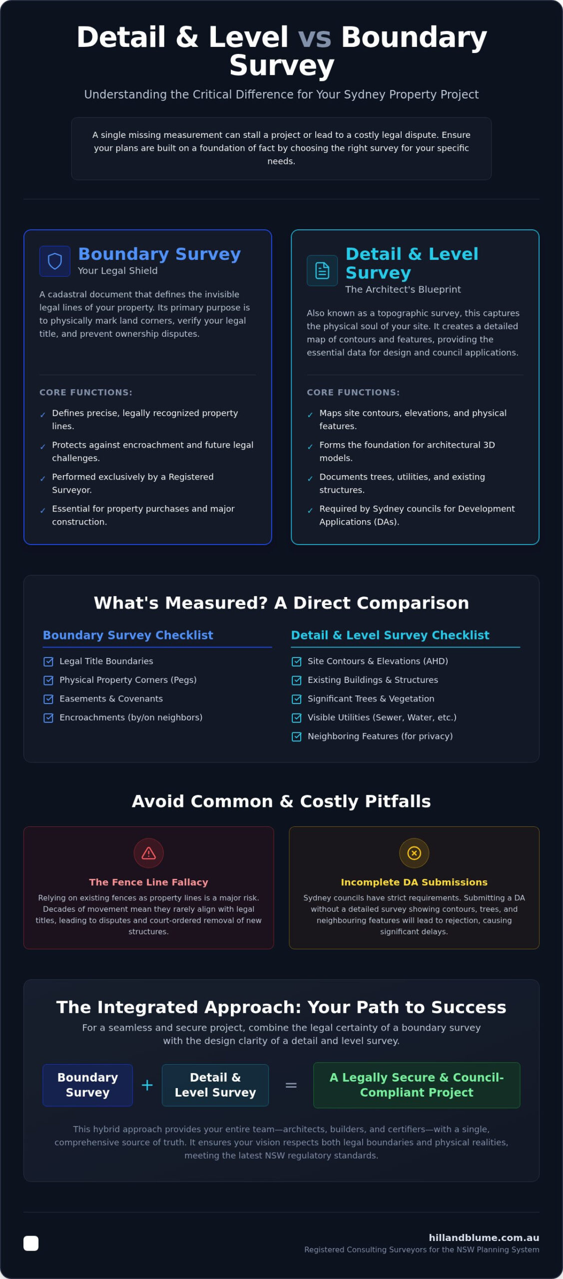
Property development in Sydney requires more than intuition; it demands absolute precision. Understanding the nuances of a detail and level survey vs boundary survey is the first step in protecting your investment and your peace of mind. While both processes involve measuring land, they serve entirely different masters. One is governed by the rigid laws of ownership and title, while the other is dictated by the fluid needs of architectural design and site analysis.
To truly appreciate these differences, one must look at what is land surveying at its core: the science of determining the three-dimensional position of points on the earth’s surface. In New South Wales, this science is strictly regulated. Only a Registered Surveyor holds the legal authority to define a boundary. This professional accreditation ensures that your property limits are recognized by the NSW Land Registry Services (LRS), providing a foundation of trust for every project we undertake at Hill & Blume.
The Boundary Survey: Your Legal Shield
A boundary survey is a cadastral document that defines the invisible lines separating your sanctuary from the rest of the world. Its primary goal is the physical marking of the land corners with survey pegs, providing a tangible reference for where your rights begin and end. This isn’t just about marking grass; it’s about verifying your legal title against historical records. For those recently purchasing a property or preparing for a high-stakes build, an Identification Survey is a specific type of boundary report we provide to ensure no encroachments or easements jeopardize your plans. It’s your insurance against future disputes and the first line of defense in any property transaction.
The Detail and Level Survey: The Architect’s Blueprint
If the boundary survey defines the “where,” the detail and level survey explains the “what.” Often referred to as a topographic survey, this captures the physical soul of your site. We document every elevation relative to the Australian Height Datum (AHD), creating a sophisticated map of contours that show exactly how the land falls. This data becomes the essential foundation for a 3D architectural model. Our team meticulously maps several key features, including:
- Existing structures, floor levels, and roof ridges.
- Significant trees, documenting trunk diameter and canopy spread for council compliance.
- Visible utility services such as sewer manholes, water meters, and electricity poles.
- Neighboring features, including window positions and balcony heights, to assess privacy and overshadowing.
By capturing these elements, we provide the clarity your design team needs to navigate the complexities of the Sydney landscape. For a comprehensive look at how these fit into your project lifecycle, you can explore our full suite of surveying services. Whether you’re building on a “zero lot line” or planning a sprawling coastal estate, starting with the right data ensures your vision remains uncompromised.
When to Order a Boundary Survey: Protecting Your Legal Interests
In many of Sydney’s historic suburbs, the weathered timber fence you share with your neighbour is often more of a suggestion than a legal fact. It’s a common misconception that property lines follow existing structures. In reality, decades of soil movement, DIY repairs, and historical errors mean that physical markers rarely align perfectly with the legal title. When you’re weighing the choice between a detail and level survey vs boundary survey, it’s vital to remember that only the latter provides a legal shield for your land ownership.
The legal consequences of “encroachment” in New South Wales are severe. If a new structure, even a gutter or a garden wall, crosses into a neighbouring lot, the court may order its removal at your expense. This is why we strongly recommend a boundary survey during the due diligence phase of any property purchase. Understanding the NSW Government boundary regulations ensures you aren’t inheriting a legal headache that could stall your future plans. Under the Surveying and Spatial Information Regulation 2024, which took effect in March 2025, the definitions and accuracy requirements for land surveys have become even more stringent. This means having a Registered Surveyor’s signature on your plans isn’t just a preference; it’s a legal necessity.
Building Near the Line: The Zero Lot Challenge
Modern Sydney architecture often seeks to maximize every square metre of land, leading to “zero lot line” designs where walls sit directly on the boundary. This leaves no room for error. A Registered Surveyor provides precision to the millimetre, ensuring your construction stays within your legal rights. Without this verification, you risk council “re-work” orders that can decimate a project budget. You can find more specific advice in our Boundary Surveys in Sydney guide, which explores how we maintain property integrity for our clients through meticulous data collection.
Resolving and Preventing Neighbour Disputes
Tension often rises when a new fence is proposed or a renovation begins. In these moments, the surveyor acts as an impartial expert, translating complex historical plans into clear, physical markers on the ground. This process, known as “re-pegging,” often de-escalates conflict by replacing assumptions with verified data. In NSW, a boundary survey by a Registered Surveyor is the only legally binding way to resolve a land area dispute. It provides a definitive answer that both parties and the law must respect, preserving the harmony of your local community.
If you’re unsure where your property truly ends, reach out to our team for a considered conversation about your site’s history and legal standing.
Why Architects Demand a Detail and Level Survey for Design and DAs
While a boundary survey secures your land’s legal footprint, an architect requires a far more intricate canvas to begin their work. In the sophisticated world of Sydney design, a detail and level survey vs boundary survey represents the shift from legal abstract to physical reality. Your architect needs to understand the rhythmic flow of your land, the way light falls across the site, and the hidden constraints that lie beneath the surface. Without this data, even the most inspired vision risks rejection by local authorities.
Sydney councils are notoriously meticulous regarding environmental impact. We provide the precise contour lines necessary for your design team to assess stormwater runoff and drainage patterns. This isn’t just about compliance; it’s about ensuring your home remains dry and stable for decades. Furthermore, in our densely populated suburbs, the “neighboring heights” we capture are vital. By mapping the exact window positions and roof ridges of adjacent properties, your architect can mathematically prove that your new build respects the privacy and sunlight of your community. This level of detail is the essential foundation for Sydney property development, turning potential council objections into a smooth approval process.
Environmental stewardship is also a core component of modern planning. Local vegetation State Environmental Planning Policies (SEPPs) require the mapping of “Significant Trees,” documenting canopy spread and trunk location with absolute accuracy. We ensure that your plans respect these natural assets, avoiding the costly delays that come with non-compliant site layouts.
Meeting Council and CDC Requirements
Whether you’re pursuing a standard Development Application (DA) or the faster Complying Development Certificate (CDC) path, the survey requirements are non-negotiable. A standard submission demands a wealth of data, from existing floor levels to the location of every permanent structure. In flood-prone regions of Sydney, Newcastle, or the Central Coast, documenting levels relative to the Australian Height Datum (AHD) is a critical requirement. These numbers aren’t just figures on a page; they’re the benchmarks council uses to determine if your project is safe for habitation.
Capturing the “Invisible” Features
Some of the most important data we provide is entirely invisible to the naked eye. We locate underground services, including sewer, water, and gas mains, to ensure your foundations don’t accidentally compromise essential infrastructure. We also meticulously map easements and “Rights of Carriageway” that may restrict your building envelope. Beyond legalities, this “Level” data is essential for your builder to calculate accurate excavation costs. Knowing the exact volume of earth to be moved prevents those unexpected budget blowouts that often haunt less-prepared projects.
Side-by-Side Comparison: Features, Outputs, and Costs
Choosing between a detail and level survey vs boundary survey isn’t merely a technical decision; it’s a strategic choice for your property’s future. While the previous sections explored the legal and architectural merits of each, understanding the tangible differences in what you receive is essential for managing your project’s timeline and budget. One provides the physical certainty of where your land ends, while the other offers a digital landscape for your vision to take shape.
The deliverables for these surveys are as distinct as their purposes. A boundary survey results in the physical placement of survey pegs at your property corners and a formal plan suitable for lodgement. In contrast, a detail and level survey typically yields a sophisticated digital CAD file and a PDF plan featuring intricate contour lines. The timeframe for each also varies. While field work for a small lot might take a few hours, the office phase involves meticulous historical research and complex calculations to ensure every millimetre aligns with NSW Land Registry Services records. Investing in this data early is a hallmark of a discerning developer; it’s far more cost-effective to identify a constraint on paper than to encounter a 10x cost increase during active construction.
Comparison Table: Boundary vs. Detail
| Feature | Boundary Survey | Detail and Level Survey |
|---|---|---|
| Primary Purpose | Define legal ownership limits | Map physical terrain and features |
| Legal Weight | High (Cadastral document) | Functional (Topographic document) |
| Key Features | Property corners, easements | Contours, trees, services, levels |
| Deliverables | Survey pegs, Title plan | Digital CAD files, PDF plans |
While a boundary survey is a legal necessity, the detail and level survey is the functional tool your design team uses daily. At Hill & Blume, we often include the boundary location within our detail surveys to provide maximum utility for your architect.
The “Efficiency Gain” of the Combined Survey
For most Sydney projects, we recommend a “Hybrid” approach. It’s significantly more efficient to have our team perform both tasks during a single site visit. By combining these services, you eliminate the need for multiple mobilisation fees and ensure that your design team is working with a “complete picture” from day one. A combined plan allows your architect to design with the absolute certainty of the legal boundary while accounting for every slope and existing structure. You can explore our full range of surveying services to see how this integrated data streamlines the council approval process.
If you’re ready to secure the precision your project deserves, request a tailored quote from our Registered Surveyors today.
Navigating the NSW Planning System with Hill & Blume
The journey from a vision to a completed residence in Sydney is paved with regulatory milestones. Choosing between a detail and level survey vs boundary survey is a decision that shapes the very foundation of your property’s future. In a city where land is precious and planning codes are intricate, the quality of your survey data acts as a silent partner in your success. At Hill & Blume, we’ve spent over nine decades perfecting this balance, providing the calm confidence that comes from absolute precision. We don’t view a survey as a mere line item in a budget; it’s the most vital project insurance you can possess.
Our team of Registered Surveyors provides more than just technical drawings. We offer a legal guarantee that your project respects the boundaries of the law and the expectations of the NSW Land Registry Services. This professional accreditation is essential in New South Wales, where only a Registered Surveyor can legally define property limits. We work in close collaboration with Sydney’s leading architects and builders, ensuring that the data we capture flows seamlessly into their design software and construction schedules. This partnership-oriented approach ensures that potential issues are identified in the quiet of our office, rather than in the noise of a construction site.
The Hill & Blume Difference: Accuracy Since 1932
Since our establishment in 1932, we’ve curated an extensive archive of land records that provide a unique window into the history of Sydney, Newcastle, and the Central Coast. These records are invaluable when identifying complex boundaries in historic suburbs where original markers may have vanished long ago. We pride ourselves on a boutique service model that prioritizes the depth of our relationship with you. You aren’t just another file in a high-volume system; you’re a partner in a shared legacy of quality. For a deeper understanding of why this professional standing is so critical, explore our Registered Surveyor Guide, which outlines the essential standards for 2026 property developments.
Next Steps for Your Property Project
The path forward begins with a considered conversation. When you’re ready to request a fee proposal, it’s helpful to have your street address or Deposited Plan (DP) number ready. This allows us to perform an initial review of the historical records associated with your site. During our site visit, our surveyors will use high-precision equipment to capture the nuances of your land, respecting your property and your privacy throughout the process. Every measurement we take is a step toward a design that is legal, accurate, and council-compliant. If you’re ready to begin your project with a safe pair of hands, contact Hill & Blume for a precise assessment of your site’s needs.
Building Your Vision on a Foundation of Certainty
Securing the future of your Sydney property begins with a single, precise decision. You now understand that while a boundary survey acts as your legal shield, a detail and level survey provides the intricate blueprint your architect needs to navigate the complexities of local council requirements. Choosing the right path between a detail and level survey vs boundary survey ensures your project moves from a conceptual dream to a physical reality without the shadow of legal disputes or design rejections. It’s about more than just measurements; it’s about the peace of mind that comes from knowing every line is backed by professional integrity and local expertise.
With 90 years of experience and a team of Registered Surveyors, Hill & Blume remains a trusted partner for high-stakes developments across NSW. We provide the precise data necessary for DA and CDC compliance, ensuring your investment is protected from the very first peg. If you’re ready to bring sophisticated clarity to your next build, we invite you to Request a Professional Survey Quote from Hill & Blume. Let’s work together to ensure your Sydney project stands on a foundation of absolute accuracy and timeless quality.
Frequently Asked Questions
Do I really need a boundary survey if there is already a fence?
Yes, you should never assume a fence line accurately represents your legal property boundary. In many of Sydney’s established suburbs, fences have been moved or replaced over decades without professional oversight, often drifting several centimetres from the true title line. A boundary survey provides the only legal confirmation of your land limits, protecting you from future disputes or the costly mistake of building a new structure on your neighbour’s land.
Can an architect perform a detail and level survey themselves?
While an architect may take their own measurements for internal design, they cannot legally produce a survey for council submission. In New South Wales, the Surveying and Spatial Information Act 2002 mandates that any survey showing or referencing property boundaries must be performed by a Registered Land Surveyor. This ensures that the data used for your Development Application is accurate, legally binding, and compliant with the latest 2025 regulatory standards.
How long does it take to complete a combined detail and boundary survey in Sydney?
You can typically expect the process to take between one and two weeks from the initial site visit to the delivery of your final plans. While our field team can often capture the physical data in a single day, the sophisticated office phase involves meticulous research into historical titles and complex calculations. This ensures that the technical nuances of your detail and level survey vs boundary survey are perfectly aligned with NSW Land Registry Services records.
What is the difference between a detail survey and a topographic survey?
These terms are essentially interchangeable within the Australian property industry. A topographic survey is the technical name for the process of mapping a site’s physical features and elevations. In Sydney, most architects and councils use the term “detail and level survey” to describe the same essential blueprint. Both provide the three-dimensional data required to understand your land’s contours, existing structures, and natural assets.
Will a detail and level survey show my neighbours property as well?
Yes, we capture specific features of adjoining properties to assist with your design’s privacy and solar access requirements. This typically includes mapping neighbouring roof ridges, floor levels, and window positions. By providing this context, your architect can accurately calculate overshadowing and ensure your new build respects the amenity of the local community, which is a critical factor in securing council approval.
How much does a boundary survey cost in NSW in 2026?
The investment for a boundary survey is determined by the unique complexities of your specific site rather than a flat rate. Factors such as the age of the original subdivision, the steepness of the terrain, and the presence of existing survey markers all influence the final fee. While it’s natural to consider the initial expense, a precise survey acts as project insurance, preventing the exponentially higher costs of legal disputes or construction delays later on.
What happens if the survey finds an encroachment on my land?
If an encroachment is discovered, the survey provides the verified evidence you need to resolve the matter through legal or collaborative channels. This might involve a formal boundary adjustment, an easement, or the removal of the encroaching structure. As Registered Surveyors, we act as impartial experts, providing the clear data required by solicitors or the court to reach a definitive resolution based on NSW property law.
Is a detail survey required for a Complying Development Certificate (CDC)?
Yes, a recent and professionally prepared detail survey is a mandatory requirement for the CDC approval path. The private certifier needs this data to verify that your proposed design complies with strict height limits, setbacks, and site coverage ratios. Because the CDC process allows for no discretion, the precision of your detail and level survey vs boundary survey is vital to ensuring your project meets every technical benchmark without delay.
Disclaimer
The information provided in articles published on this website is for general informational purposes only. While we make every effort to ensure the accuracy, completeness, and timeliness of the content, the material is based on our understanding of the industry at the time of writing and may not reflect the most current developments, regulations, or standards. All opinions expressed in our articles are those of the respective authors and do not necessarily represent the official position of the website or its affiliates. The content should not be considered professional, legal or technical advice, and should not be relied upon as a substitute for consultation with qualified professionals