
A single millimetre on a digital plan might seem inconsequential, but to a Council assessor, it’s the difference between a project that breaks ground and one that breaks your budget. It’s incredibly frustrating to see your vision stalled because of technicalities you thought were handled months ago. You’ve likely invested significant time and consultant fees, only to find your DA rejected due to inaccurate survey data that doesn’t meet the strict standards of the NSW Planning Portal. This setback is often the result of a survey that lacks the precision required by the latest regulatory standards.
We understand that these delays feel like more than just a paperwork error; they represent a pause on your lifestyle aspirations and a drain on your resources. You deserve a partnership that prioritizes depth of detail over high-volume turnover. Discover why these survey inaccuracies lead to Council rejections and the exact steps to rectify your application with professional surveying precision. This guide explores the impact of the Surveying and Spatial Information Regulation 2024 and provides a clear path toward a compliant DA, ensuring your project moves forward without further requests for information.
Key Takeaways
- Learn exactly why a DA rejected due to inaccurate survey data occurs and how to decode the specific technical feedback from your Council Assessment Officer.
- Identify the most common technical discrepancies, from misaligned AHD levels to incorrect boundary setbacks, that trigger automatic refusals in 2026.
- Understand the legal necessity of engaging a NSW Registered Surveyor to provide the certified signatures and precision required for Planning Portal compliance.
- Follow a structured five-step recovery plan to audit your current application and replace flawed data with a professional Detail and Level Survey.
- Discover how partnering with a boutique agency with 90 years of local expertise can streamline your resubmission and protect your project from further delays.
The Hidden Cost of Inaccuracy: Why Council Rejects DAs Based on Surveys
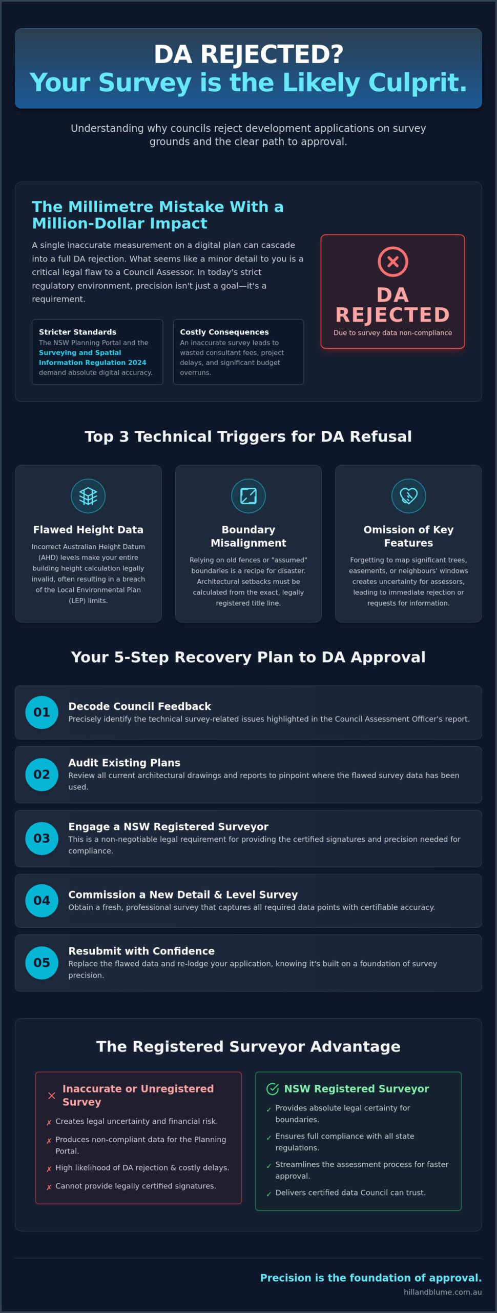
In the eyes of a NSW Council Assessment Officer, a survey isn’t just a technical drawing. It is the legal foundation of your entire proposal. When you find your DA rejected due to inaccurate survey data, it often stems from a fundamental mismatch between the physical reality of your site and the digital requirements of the NSW Planning Portal. In 2026, this scrutiny has reached a new peak. With the mandatory inclusion of LandXML digital plan files and the commencement of the Surveying and Spatial Information Regulation 2024, there’s no longer room for “near enough” measurements.
Every architectural line, from your roof pitch to your driveway gradient, relies on the underlying survey. This precision is vital because NSW operates under the Torrens title system, which requires absolute certainty regarding land boundaries to maintain the integrity of the state’s land register. A discrepancy of just 100mm in a boundary position or a ground level can render an entire design non-compliant. It’s a small error that creates a massive project halt, often after you’ve already paid thousands in architectural fees and consultant reports.
The Relationship Between Survey Data and Conditions of Consent
Inaccurate height data frequently leads to breaches of Local Environmental Plans (LEPs), particularly regarding maximum building heights. If your survey fails to correctly identify the lowest point of the ground, your entire height calculation is flawed. Council cannot, and will not, grant consent on uncertain data. This is why professional boundary surveys are non-negotiable; they provide the legal certainty that allows an assessor to sign off on your vision with confidence. Without this clarity, your project remains a risk the Council isn’t willing to take.
Refusal vs. Request for Information (RFI)
It’s vital to identify if your application is truly dead or simply paused. An RFI (Request for Information) means the Council has identified gaps but is giving you a chance to rectify them. However, if the discrepancies are deep-seated, you may face a formal refusal or a “deferred commencement.” Reading the Assessment Officer’s notes is a specialized skill. They might highlight that site boundaries on drawings don’t match the registered survey, a common error that makes the application technically “un-assessable.” While a fresh Detail and Level Survey requires an initial investment, it’s far more cost-effective than enduring multiple rounds of RFIs that lead to nothing but frustration and mounting consultant fees.
Common Technical Discrepancies That Trigger a DA Refusal
When you receive word that your DA rejected due to inaccurate survey data, the cause is often found in the technical nuances of the site plan. Council assessors don’t just look at your proposed walls; they look at the relationship between those walls and the world around them. If your Australian Height Datum (AHD) levels are calculated from an unverified benchmark, your entire building height limit becomes a legal liability. Even a minor discrepancy in ground level can result in a proposal that technically exceeds the Local Environmental Plan (LEP) height restrictions, leading to an immediate refusal.
Beyond levels, the omission of physical features is a common trigger for rejection. Assessors look for a complete narrative of the site, and leaving out key details creates “uncertainty,” which is the enemy of an approval. Common omissions include:
- Failing to map significant trees on your property or those within five metres of the boundary on a neighbour’s lot.
- Neglecting to show the exact location and width of registered easements or rights of way.
- Overlooking neighbouring structures, such as secondary dwellings or windows, that influence overshadowing and privacy assessments.
Boundary Misalignment and Setback Failures
Many homeowners mistakenly believe that a long-standing fence line dictates their property boundary. In reality, fences are often several centimetres, or even decimetres, away from the true title line. Relying on “assumed” boundaries for your architectural plans is a recipe for DA disaster. This is where Identification Surveys become essential. They verify the exact building positions relative to the legal title, ensuring your setbacks are calculated with surgical precision. If your project proceeds with incorrect offsets, you risk costly Land and Environment Court disputes that can stall a development for years. Preventing a DA rejected due to inaccurate survey by identifying these discrepancies early is the hallmark of a meticulous planning process.
Topographic and Level Errors
A successful application requires more than just knowing your own land. High-quality contour and detail surveys must include neighbouring floor levels and ridge heights to accurately assess privacy and overshadowing. In 2026, Sydney councils are increasingly utilizing sophisticated 3D modelling and digital twins to overlay your proposed plans onto the existing urban landscape, making it impossible for level errors to go unnoticed. If your survey doesn’t provide the depth of data required for these digital assessments, your application will likely be sent back for revision. If you have already received a refusal letter, speaking with a registered professional can help you decode the specific technical errors cited by your assessor.
The Risk of Using Unregistered Surveyors for Your Sydney Project
In the high-stakes world of Sydney property development, the title “surveyor” is often used loosely, yet the legal distinction is absolute. While many individuals can operate a laser level, only a Registered Surveyor possesses the statutory authority to define land boundaries in New South Wales. This isn’t merely a matter of professional pride; it’s a legal safeguard that protects the integrity of your property title. When you find your DA rejected due to inaccurate survey data, it is frequently because the work was performed by an unregistered individual whose plans lacked the necessary certification to pass Council’s rigorous pre-lodgement checks.
The “Cheap Survey” trap is a familiar story for many who face project delays. Saving a few hundred dollars on a budget service might feel like a win during the initial consultant phase, but it often leads to tens of thousands of dollars in wasted time and holding costs. If a building is set out based on an uncertified plan and eventually encroaches on a neighbour’s land, the liability falls squarely on the property owner. Professional indemnity insurance for registered professionals, often managed through specialists like MyGen Insurance Brokers, provides a layer of protection that budget operators simply cannot offer. This peace of mind is invaluable when your project’s progression is on the line.
NSW Statutory Requirements for Boundary Definition
The Surveying and Spatial Information Act 2002 remains the cornerstone of land law in our state, and its 2026 updates have only tightened the requirements for digital accuracy. Only a registered professional can legally sign off on the boundary dimensions that form the basis of your development. Council Assessment Officers regularly verify credentials against the Board of Surveying and Spatial Information (BOSSI) database. If the name on your survey doesn’t appear on that list, your application is essentially dead on arrival. Ensuring your DA rejected due to inaccurate survey issues are resolved starts with verifying the credentials of your chosen partner.
Professional Integrity vs. Budget Services
Choosing a boutique firm with deep local roots offers more than just a signature. At Hill & Blume, our 90-year archive of Sydney survey records allows us to locate “lost” boundary marks that newer, high-volume agencies often miss. We view surveying as a craft that requires patience and historical context, not just modern equipment. This depth of relationship with the local landscape ensures that your Identification Survey is a definitive statement of truth. It provides the calm confidence needed to move your project through the NSW Planning Portal without the fear of technical discrepancies stalling your vision.
Recovery Plan: 5 Steps to Rectify an Inaccurate Survey
Facing a refusal is a setback, but it isn’t the end of your project’s journey. We view this recovery as a curated process of restoring integrity to your application. If you have had a DA rejected due to inaccurate survey data, following a structured path is the most efficient way to regain Council’s trust and secure your approval. This isn’t about simply patching old drawings; it’s about establishing a new, indisputable foundation of truth for your site.
Our recommended recovery plan involves five deliberate steps:
- Step 1: Audit the refusal. Carefully review the Assessment Officer’s notes or the formal RFI. Identify whether the issue lies in level discrepancies, boundary misalignments, or missing site features.
- Step 2: Engage a Registered Surveyor. Replace flawed data with a fresh Detail and Level Survey. This ensures your new plans meet the technical rigour required by the Surveying and Spatial Information Regulation 2024.
- Step 3: Re-verify boundaries and easements. Perform an Identification Survey to resolve any “uncertainty” regarding title lines. This step is vital if your refusal cited setback breaches or easement encroachments.
- Step 4: Update architectural plans. Your design team must adjust their CAD files to match the new survey data exactly. This alignment prevents the “inconsistent documentation” errors that plague many failed applications.
- Step 5: Resubmit via the NSW Planning Portal. Lodge your amended plans alongside a Surveyor’s Certificate, providing a seal of quality that reassures the Council of your proposal’s accuracy.
Coordinating the “Fix” with Your Design Team
Precision is a collaborative effort. Your architect relies on the surveyor’s data to calculate floor space ratio (FSR) and building heights with total certainty. In the 2026 planning environment, digital data compatibility is paramount; all submissions must include LandXML digital plan files that reflect your site’s physical reality. By ensuring your architect’s files are perfectly synced with our survey, you eliminate the technical friction that often leads to a DA rejected due to inaccurate survey. This synergy, often bolstered by the expertise of PK Services in redefining excellence within the Australian construction industry, allows your design team to address Council’s specific concerns regarding height limits and overshadowing with absolute confidence.
Negotiating with Council Post-Refusal
A professional survey report serves as powerful “expert evidence” if you choose to pursue a Section 8.2 Review of the Council’s decision. During meetings with Assessment Officers, having a Registered Surveyor present can turn a “No” into a “Yes” with conditions. We can explain the technical methodology behind the levels and boundaries, resolving disputes that an architect or town planner might not be equipped to handle. If you’re ready to move past the frustration of a stalled project, reach out to our team to begin your recovery audit.
Securing Your DA Approval with Hill & Blume’s Precision
The journey from a refusal letter to a construction site requires more than just a new set of drawings. It demands a partnership with experts who value quality over volume. If you have experienced the frustration of a DA rejected due to inaccurate survey data, you know that technical precision is the only way to move forward. We provide that certainty. Our approach combines a deep respect for the local landscape with a sophisticated understanding of NSW planning requirements, ensuring your project regains its momentum with a foundation of absolute truth.
Our 90 years of industry experience allows us to navigate the complexities of Sydney’s urban fabric with ease. We don’t just provide data; we provide a curated experience that respects your time and your vision. Whether you are developing a boutique residence in Crows Nest or a sprawling estate on the Northern Beaches, our team delivers Detail and Level Surveys that are meticulously prepared for Council scrutiny. We transform technical hurdles into clear pathways for progression, moving your project from rejection to construction with calm confidence.
The Hill & Blume Difference: Accuracy Guaranteed
Precision is a hallmark of our craft. We utilize the latest Leica technology to capture every contour and boundary mark with surgical accuracy. This high-end equipment is paired with traditional boundary research, a process that draws on our extensive internal archives to resolve discrepancies that others might overlook. Architects across Sydney trust our data for their most ambitious designs because they know our signatures represent a seal of quality. In 2025, we saved a significant residential project from a total halt by resolving a boundary dispute that had been triggered by a previous, lower-quality survey. By identifying the true title line, we provided the evidence needed to turn a Council refusal into a successful approval.
Ready to Fix Your DA?
Rectifying a failed application starts with a clear understanding of what went wrong. We are ready to help you decode the technical feedback from your Assessment Officer and provide the professional documentation required for a successful resubmission. To provide an accurate quote for a rectification survey, we typically need a few key items:
- A copy of your Council refusal letter or Request for Information (RFI).
- The existing survey that was deemed inaccurate.
- Your current architectural site plan.
We believe in a partnership-oriented narrative that prioritizes your project’s success. Don’t let a technicality stand in the way of your lifestyle aspirations. Our team is here to ensure your next submission is your final one. To begin the process of restoring integrity to your development application, consult with a Registered Surveyor at Hill & Blume today. We look forward to helping you build with precision and peace of mind.
Restoring Momentum to Your Property Vision
Discovering your DA rejected due to inaccurate survey data is undeniably a setback, but it also provides a clear opportunity to establish a flawless foundation for your build. By replacing technical uncertainty with the surgical precision of a Registered Surveyor, you provide the Council with the absolute clarity they require to move your project forward. We’ve explored how identifying boundary discrepancies and updating your plans with 2026 digital standards can transform a frustrating refusal into a compliant approval. It’s about moving from a state of confusion to a place of calm confidence.
With over 90 years of Sydney surveying expertise, our team at Hill & Blume specializes in DA compliance and navigating complex boundary disputes. We understand that your home is more than just a project; it’s a lifestyle investment that deserves the highest level of professional craftsmanship. Our Registered NSW Surveyors are ready to help you navigate the path to recovery with effortless service and technical rigour. Get a Precise Survey Quote for Your DA Recovery and let’s ensure your next lodgement is the final one. Your vision is within reach, and we’re dedicated to helping you secure it with the precision it deserves.
Frequently Asked Questions
Can Council reject my DA if the survey is only slightly off?
Yes, Council can and frequently does reject applications for minor discrepancies. In the technical world of planning, “slightly off” can mean a breach of statutory height limits or illegal setbacks. When you find your DA rejected due to inaccurate survey data, it’s because the assessor cannot grant legal consent based on uncertain measurements. Precision is a requirement, not a suggestion, for any successful NSW submission.
What is the difference between a Detail Survey and a Boundary Survey?
A Detail Survey maps the physical topography and features of your land, while a Boundary Survey legally defines your property’s title lines. You typically need a combination of both for a Development Application. The Detail Survey allows your architect to design with the land’s contours, while the Boundary Survey ensures your proposal respects legal setbacks and doesn’t encroach on neighbouring lots.
How much does it cost to fix an inaccurate survey in Sydney?
The cost of rectification varies depending on the complexity of your site and the specific errors identified in your Council refusal. While we don’t quote fixed industry rates, the investment in a fresh, professional survey is significantly lower than the holding costs of a stalled project. Rectifying your application involves a comprehensive audit and a new site visit to establish an indisputable foundation of truth.
Do I need a new survey if I am only doing a small renovation?
You usually need a current survey if your renovation alters the building footprint or height. Council requires up-to-date site data to assess how even modest changes impact overshadowing and privacy for your neighbours. If your existing plans don’t reflect the current state of the property or neighbouring structures, they likely won’t meet the strict submission standards required by the NSW Planning Portal.
How long does a Registered Surveyor take to complete a DA-ready survey?
A standard residential survey typically takes between one and two weeks from the initial site visit to the delivery of certified digital plans. This timeframe allow us to perform essential boundary research and verify ground levels against established benchmarks. More complex urban sites may require additional time to ensure every significant tree and neighbouring structure is captured with the required depth of detail.
What happens if my building has already started and the survey is found to be wrong?
This scenario often requires an immediate halt to construction and a formal modification to your development consent. If a DA rejected due to inaccurate survey issues surfaces during the build, you may need to lodge a Section 4.55 modification supported by a Work-as-Executed (WAE) survey. It’s a costly and stressful process that emphasizes why starting with professional surveying precision is vital for your peace of mind.
Why does Council require an Identification Survey for my DA?
Council requires an Identification Survey to provide legal certainty that your proposed works are contained within your property boundaries. It proves that your setbacks are calculated from the actual title line rather than an assumed fence or landmark. This document protects you from future legal disputes and ensures that your development respects all registered easements and rights of way on the land.
Can I use a survey from 10 years ago for my new DA?
It’s highly unlikely that an old survey will be accepted for a new application. Site conditions change over a decade, and modern 2026 regulatory standards require digital compatibility, such as LandXML files, that older surveys simply don’t provide. Using outdated data often leads to a DA rejected due to inaccurate survey because it fails to account for new neighbouring developments or changes in site topography.
Disclaimer
The information provided in articles published on this website is for general informational purposes only. While we make every effort to ensure the accuracy, completeness, and timeliness of the content, the material is based on our understanding of the industry at the time of writing and may not reflect the most current developments, regulations, or standards. All opinions expressed in our articles are those of the respective authors and do not necessarily represent the official position of the website or its affiliates. The content should not be considered professional, legal or technical advice, and should not be relied upon as a substitute for consultation with qualified professionals