

Could a single millimetre of discrepancy on your property boundary be the difference between a seamless renovation and a multi-month council stalemate? In the sophisticated landscape of Sydney property development, the answer is often a resounding yes. Securing a meticulous survey plan for da submission sydney is far more than an administrative hurdle; it’s the foundational layer of your project’s legal and architectural integrity. When you’re navigating the nuances of local environmental plans and the high stakes of urban design, you deserve data that mirrors the reality of your land with absolute fidelity.
You likely understand the quiet anxiety that comes with lodging documents through the NSW Planning Portal, where even a minor oversight can trigger a series of costly delays. This 2026 professional guide ensures your submission is compliant, precise, and protected against the common pitfalls that stall so many Sydney projects. We’ll explore the vital distinctions between detail and boundary surveys, examine the latest council requirements for the 2025/2026 period, and provide the legal certainty you need to transform your vision into a reality. By the end of this article, you’ll have a clear roadmap for a successful, stress-free approval process that respects both your time and your investment.
Key Takeaways
- Understand why a meticulous survey plan for da submission sydney is the essential first step to meeting the rigorous compliance standards of local councils.
- Discover how capturing precise site data—from existing utilities to tree canopies—provides a seamless foundation for your architectural design and prevents costly revisions.
- Learn why legal boundary certainty is the only way to safeguard your project against the delays and disputes that often arise during the neighbor notification period.
- Master the technical requirements of the NSW Planning Portal by ensuring your digital survey files are perfectly aligned with your site plans and elevations.
- Appreciate the peace of mind that comes from engaging a specialized local authority with a legacy of providing crafted, detail-oriented surveying solutions.
Understanding the Survey Plan Requirement for Sydney DA Submissions
Think of your survey plan as the digital DNA of your property. It is far more than a simple drawing of your backyard; it is a precise mathematical representation of your land’s physical and legal characteristics. When you prepare a survey plan for da submission sydney, you are creating the definitive record that architects, engineers, and council planners rely on to make informed decisions. This document captures the exact nuances of your site, from the subtle slope of the terrain to the hidden utility lines that could dictate the placement of a new foundation.
Sydney’s local councils, such as the City of Sydney or North Sydney, require these plans to be prepared by registered professionals to ensure every proposed change aligns with the broader vision for urban planning in Australia. These authorities have a responsibility to protect the character of our neighborhoods and the rights of your neighbors. Without a certified survey, a council cannot verify if your proposal meets the stringent requirements of the Local Environmental Plan (LEP), which governs everything from building heights to floor space ratios.
Each LEP contains specific controls that are unique to your suburb. If your survey data is even slightly inaccurate, it can trigger a “Request for Information” (RFI) from council planners. These requests are the most common cause of project stagnation, often adding weeks or months to your timeline. By providing a high-fidelity survey from the outset, you demonstrate a commitment to precision that reassures the council and paves the way for a smoother approval process.
The Legal Necessity of a Registered Surveyor
In New South Wales, the law is clear: only a Registered Land Surveyor holds the legal authority to certify property boundaries. This isn’t just a matter of technical skill; it is a matter of liability and legal certainty. Using uncertified data or old site plans for a modern development is a risk that can lead to boundary disputes or physical encroachments. At Hill & Blume, we bring a legacy of 90 years in Sydney’s regulatory landscape to every project. We understand the specific nuances of local council expectations, providing a boutique service that larger, more clinical agencies simply cannot match. You can explore our full range of professional surveying services to see how we provide this essential certainty.
DA vs. CDC: Do Survey Requirements Change?
Whether you are pursuing a traditional Development Application or a Complying Development Certificate (CDC), the need for precision remains constant. While the CDC pathway is often faster, it requires even stricter adherence to set standards. A comprehensive survey supports both pathways seamlessly, allowing you to pivot your strategy if your planning goals evolve. We always recommend consulting with your planning advisers before commissioning your plan to ensure every specific detail required by your chosen pathway is captured with millimetre precision. This proactive approach protects your investment and ensures your design is built on a foundation of absolute truth.
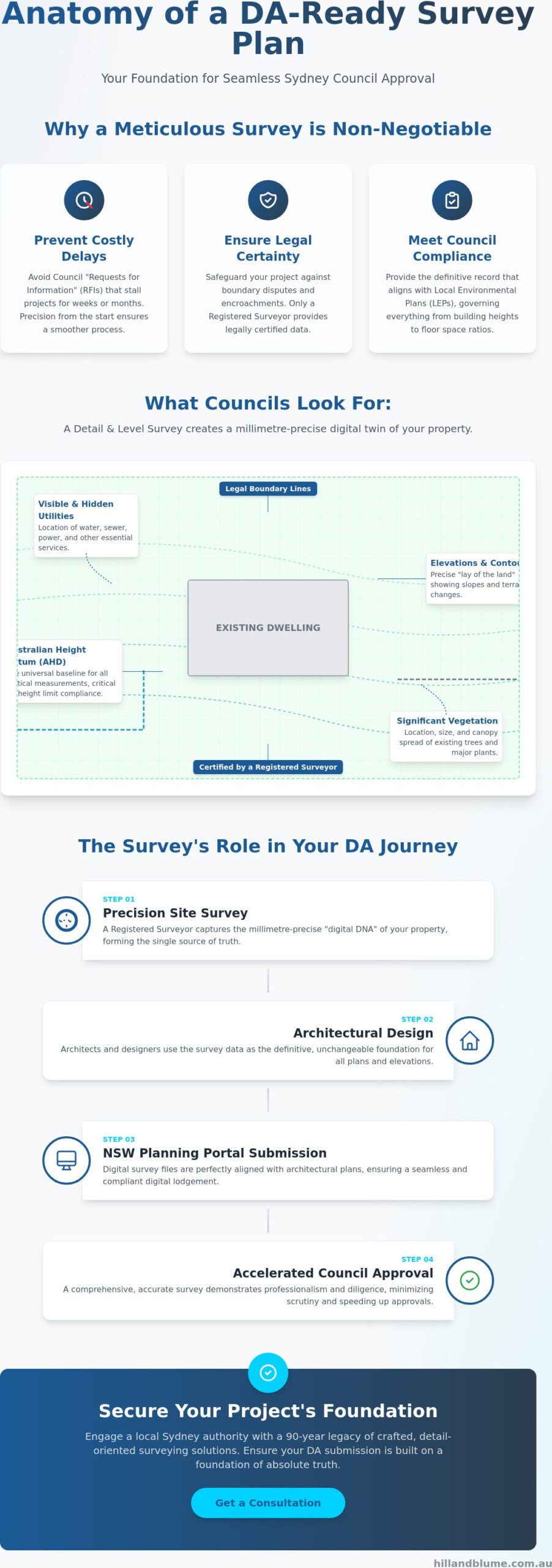
The Anatomy of a Detail and Level Survey: What Councils Look For
A Detail and Level Survey is the essential bridge between your creative vision and the physical constraints of your site. While some view it as a mere checklist item, it is actually the most influential design tool in your architect’s arsenal. When you commission a survey plan for da submission sydney, you are capturing a millimetre-precise digital twin of your land. This isn’t just about where the grass ends and the driveway begins; it’s about the complex interplay of elevations, existing structures, and the unique “lay of the land.”
One of the most critical components is the Australian Height Datum (AHD). This standardized vertical reference ensures your project’s floor levels and roof heights are measured against a universal baseline. Sydney councils are uncompromising when it comes to height limits and floor space ratios. If your survey data lacks this rigorous vertical accuracy, you risk designing a home that technically violates local height restrictions, potentially leading to a forced redesign during the assessment phase. All professional work must adhere to the NSW Surveying and Spatial Information Regulation, which sets the standard for how this data is collected and presented to government authorities.
Beyond your own boundaries, councils look for details regarding neighboring properties. This includes the position of windows, eaves, and floor levels of the houses next door. Planners must assess how your new build will impact privacy and overshadowing for those living around you. A survey that omits these details is incomplete and will likely trigger a request for more information, stalling your progress just as you hope to move forward.
Contour Lines and Site Slope
Contour lines provide the topographic narrative of your property. They inform every aspect of your project’s engineering, from the depth of excavation to the design of sophisticated drainage systems and retaining walls. Without accurate site levels, your builder cannot provide a fixed-price contract, leaving you vulnerable to site cost blowouts during construction. Contour intervals are typically selected at 0.5-metre increments to accurately reflect the varied and often challenging terrain of Sydney’s coastal and inland suburbs.
Vegetation and Utility Mapping
In Sydney’s leafy suburbs, trees are more than just landscaping; they are protected assets. Your survey must map significant tree trunks and their canopy spreads to comply with local environmental protection orders. Equally vital is the mapping of utility services. Identifying the precise location of sewer mains, water lines, and electrical conduits prevents design conflicts that are expensive to rectify once construction begins. You can learn more about how we capture these critical site features through our Contour and Detail Survey Services. If you’re ready to ensure your project is built on a foundation of absolute accuracy, we invite you to reach out to our team for a tailored consultation that respects the unique character of your property.
Beyond the Basics: Why Boundary Identification is Critical for DA Approval
Many homeowners make the quiet assumption that their existing fence lines represent the absolute legal limits of their property. It’s a common misconception. In the eyes of the law, a weathered timber fence is rarely a definitive marker of ownership. When you prepare a survey plan for da submission sydney, you are looking for legal certainty that transcends physical structures. Relying on assumed boundaries is a risk that can lead to devastating setbacks, particularly during the neighbor notification period of your application. If a neighbor identifies a potential encroachment based on your plans, your entire project can be derailed before the first brick is laid.
An Identification Survey acts as your legal shield. It confirms your right to build to the boundary by reconciling the physical site with the official title records. This process protects your investment from future disputes with adjoiners, ensuring that your new addition or renovation sits entirely within your legal domain. It provides the peace of mind that comes from knowing your property’s integrity is beyond reproach. By establishing these facts early, you remove the ambiguity that often fuels conflict between neighbors.
Easements and Covenants
Your property’s title often carries invisible layers of complexity known as easements and covenants. These might include a “Right of Carriageway” for a neighbor or an “Easement for Services” that restricts where you can build. These are governed by Section 88B instruments, which can significantly impact your building footprint. Our Guide to Boundary Surveys in Sydney provides deeper insight into how these legal encumbrances are identified and managed. Understanding these limitations early prevents the heartbreak of designing a space that simply cannot be built.
The Identification Survey Report
A formal Identification Survey Report is a specialized legal instrument that accompanies your plan. It provides a detailed narrative of any encroachments, the relationship between fences and boundaries, and verification that your proposed works adhere to legal property setbacks. For a council planner, this report serves as a seal of quality for your submission. It signals that you have engaged with the site’s legal realities with professional care, reducing the likelihood of administrative delays and fostering a sense of trust in your project’s foundations.
Navigating the NSW Planning Portal: Integrating Your Survey Data
The transition from the physical terrain to the digital screen is a pivotal moment in your property’s journey. Since the NSW Planning Portal became the mandatory gateway for all local developments, the way we handle a survey plan for da submission sydney has fundamentally changed. It is no longer enough to have a precise drawing; that data must now exist in a format that speaks the same language as the portal’s sophisticated interface. This digital integration ensures that every stakeholder, from your architect to the council planner, is working from a single version of the truth.
Your submission requires a delicate synchronization of files. We provide your design team with high-fidelity CAD data (DWG formats) to form the base of their architectural drawings, alongside the formal PDF versions required for council lodgement. If the survey data doesn’t perfectly align with your proposed site plans and elevations, the portal’s automated checks or a manual review by a planning officer will likely flag a discrepancy. This leads to the administrative friction of an RFI, which can be avoided through meticulous preparation. As the portal continues to evolve, including the significant May 1, 2026, system release, staying current with these technical requirements is essential for a seamless approval.
The lifecycle of your project within the portal often concludes with a Work-as-Executed (WAE) survey. This final document confirms that the finished building matches the approved plans, allowing for the release of your Occupation Certificate. It is the closing of the circle, proving that the precision promised at the start was delivered in the final build.
Collaborating with Your Design Team
We don’t just deliver a static document; we provide a dynamic digital foundation. By providing CAD data directly to your architect, we streamline the design phase and eliminate the risk of manual transcription errors. Sometimes, our measurements reveal discrepancies between historical titles and the current site reality. We resolve these nuances early, maintaining a steady rhythm of communication between your design team and our surveyors. This collaborative approach ensures that your vision is built on a foundation of absolute accuracy. If you’re looking for a partner who values this level of detail, we invite you to speak with our specialist team today.
Submission Checklist for Success
Before you hit the “submit” button on the Planning Portal, ensure your survey plan meets these essential criteria for council acceptance:
- Confirm the Lot and Deposited Plan (DP) numbers match your title search exactly.
- Ensure the North Point and scale are clearly defined and legible in digital format.
- Verify the survey is current, ideally performed within the last 12 months to reflect any recent site changes.
- Check that all easements and Section 88B instruments identified on the title are clearly plotted.
- Ensure the surveyor’s registration details and signature are prominently displayed.
Partnering with Hill & Blume: Precision Surveying for Your Sydney Project
Since 1932, Hill & Blume has served as a steady hand for property owners navigating the complexities of land development. We understand that your home or commercial project is more than just a structure; it’s a significant investment and a chapter in your life’s story. When you choose us to prepare your survey plan for da submission sydney, you aren’t just hiring a technician. You’re engaging a partner who values quality over quantity. Our legacy is built on the belief that every site has a unique narrative that deserves to be captured with absolute fidelity and professional care.
We bring this specialized local expertise to projects across Sydney, Newcastle, and the Central Coast. By choosing a boutique firm, you ensure your project receives the discerning, detail-oriented attention it requires. Precision during the DA phase is the most cost-effective insurance you can buy for your build. It prevents the mid-construction surprises that lead to budget overruns and legal headaches. We provide the calm confidence you need to move forward, knowing your project is anchored by traditional integrity and modern technical excellence.
A Sophisticated Approach to Professional Consulting
Our firm prioritizes the depth of our relationships over high-volume turnover. We take the time to understand your specific aspirations, offering a level of meticulous detail that larger, more clinical agencies often overlook. This commitment to craftsmanship defines our Hill & Blume Professional Services. We pair our nearly century-long history with the latest surveying technology to ensure your data is as current as it is accurate. It’s a seamless blend of old-world care and modern precision that mirrors the high-end lifestyle our clients pursue.
Next Steps for Your DA
Moving from a creative vision to a formal application requires a clear, reliable roadmap. To begin, we invite you to request a bespoke quote tailored to the specific complexities and nuances of your site. Providing us with your property address, a brief overview of your proposed development, and any existing title documents allows us to perform an accurate project assessment. This considered conversation is the first step toward a successful, stress-free submission. We invite you to Enquire with Hill & Blume for your DA Survey Plan and discover the peace of mind that comes from working with true local authorities who value your project as much as you do.
Building Your Vision on a Foundation of Certainty
Your journey through the approval process is a testament to your vision for a more refined lifestyle. As we’ve explored, the success of this journey depends on the technical and legal integrity of your site data. From capturing the intricate nuances of your property’s topography to establishing the absolute legal certainty of your boundaries, a meticulous survey plan for da submission sydney is your most powerful asset. It transforms the digital requirements of the NSW Planning Portal into a seamless bridge between your architect’s creativity and the council’s rigorous standards.
At Hill & Blume, we offer a boutique service tailored to the specific needs of discerning architects and developers. Our team of Registered NSW Land Surveyors brings over 90 years of Sydney surveying expertise to your project, ensuring every detail is captured with a signature touch of quality. We invite you to Request a Bespoke Survey Quote for Your Sydney DA today. Let us provide the precision and peace of mind your investment deserves. It’s time to build your future on a foundation of absolute truth.
Frequently Asked Questions
Do I need a new survey plan if I have one from a previous owner?
You should typically commission a new plan if your existing survey is more than 12 months old or if significant site changes have occurred. Councils in Sydney often mandate current data to ensure your design reflects the present state of the land. An outdated plan might miss new neighboring structures or recent tree growth, which could lead to complications and delays during the assessment phase.
How long does a Detail and Level survey take to complete in Sydney?
A standard residential Detail and Level survey usually requires one day of fieldwork followed by several days of meticulous data processing and drafting. While the physical measurement is efficient, the true craftsmanship lies in the digital integration of legal boundaries and topographic features. You can typically expect to receive your completed digital files within one to two weeks of the site visit.
What is the difference between a contour survey and a DA survey plan?
A contour survey is a specific component that maps the slopes and elevations of your land, whereas a survey plan for da submission sydney is a comprehensive legal document. This submission-ready plan integrates those topographic contours with critical boundary data, utility locations, and neighboring property features. It is the holistic representation of your site’s physical and legal reality required by council planners.
Can an architect prepare the survey plan for my DA submission?
Architects are masters of design, but they do not have the legal authority to certify property boundaries or site levels in New South Wales. Only a Registered Land Surveyor can provide the certified data required for a formal submission. Your architect will use the surveyor’s high-fidelity CAD files as the essential foundation for their own architectural drawings and site plans.
How much does a survey plan for a DA submission cost in Sydney?
The investment for a professional survey varies based on your property’s size, the complexity of its terrain, and the specific requirements of your local council. A steeply sloping site with dense vegetation or complex historical boundaries requires more intensive fieldwork and analysis than a flat, clear lot. We recommend requesting a bespoke quote to ensure your specific project needs are accurately assessed and met.
What happens if my survey shows my fence is not on the boundary?
Discovering that a fence is misaligned with the legal boundary is a common occurrence in established Sydney suburbs. Your survey plan will clearly identify these discrepancies, allowing you to design your project within the true legal limits of your land. This early detection is vital, as it prevents building encroachments that could lead to costly legal disputes or the refusal of your Development Application.
Does the survey plan include underground services like pipes and cables?
A professional survey includes the mapping of visible surface indicators for underground utilities, such as sewer manholes, water meters, and electrical pits. While we reference official utility data, the survey provides the physical location of these services relative to your proposed build. This ensures your design respects essential infrastructure and avoids the high costs of relocating major utility lines during construction.
Is a survey required for a minor renovation or granny flat?
Most councils require a professional survey plan for da submission sydney for any project that alters the building footprint or adds a secondary dwelling like a granny flat. Even minor renovations often necessitate precise site levels to calculate floor space ratios and height limits. Providing accurate data from the outset ensures your project complies with the specific standards of your local environmental plan.
Disclaimer
The information provided in articles published on this website is for general informational purposes only. While we make every effort to ensure the accuracy, completeness, and timeliness of the content, the material is based on our understanding of the industry at the time of writing and may not reflect the most current developments, regulations, or standards. All opinions expressed in our articles are those of the respective authors and do not necessarily represent the official position of the website or its affiliates. The content should not be considered professional, legal or technical advice, and should not be relied upon as a substitute for consultation with qualified professionals