
What if the most challenging acre of your next project could be mapped with millimetre precision before your morning coffee has even cooled? You likely understand the traditional hurdles of surveying for property development sydney, where steep, unstable terrain or expansive sites often lead to safety concerns and frustrating delays in data processing. It’s a delicate balance to maintain, especially when the success of your DA submission relies on the absolute accuracy of your site assessments.
In 2026, the landscape of land measurement has shifted, with over 38,000 licensed drone operators in Australia now providing a high-fidelity lens that amplifies the expertise of a Registered Surveyor. This guide explores how advanced aerial technology is revolutionising property development across New South Wales, offering you faster turnarounds and highly detailed 3D digital twins. You’ll discover how these sophisticated tools reduce project risk through superior data, ensuring your vision is built on a foundation of clarity and local insight. We’ll preview the latest CASA regulations and the seamless integration of cloud-based processing that keeps your project moving with calm, measured confidence.
Key Takeaways
- Understand how the shift from traditional ground-based measurements to aerial data capture is streamlining the timeline for your next project.
- Discover the specific advantages of LiDAR technology for “seeing through” dense canopy, ensuring accuracy even on the leafiest Sydney sites.
- Learn why drone precision is a powerful tool that works in harmony with, rather than replaces, the essential legal oversight of a Registered Surveyor.
- Explore how surveying for property development sydney now utilizes millions of data points to create immersive 3D digital twins of your land.
- Navigate the evolving 2026 CASA regulations to ensure your aerial surveys remain compliant within Sydney’s complex and restricted airspace.
The Evolution of Precision: Why Drone Surveying is Reshaping Sydney in 2026
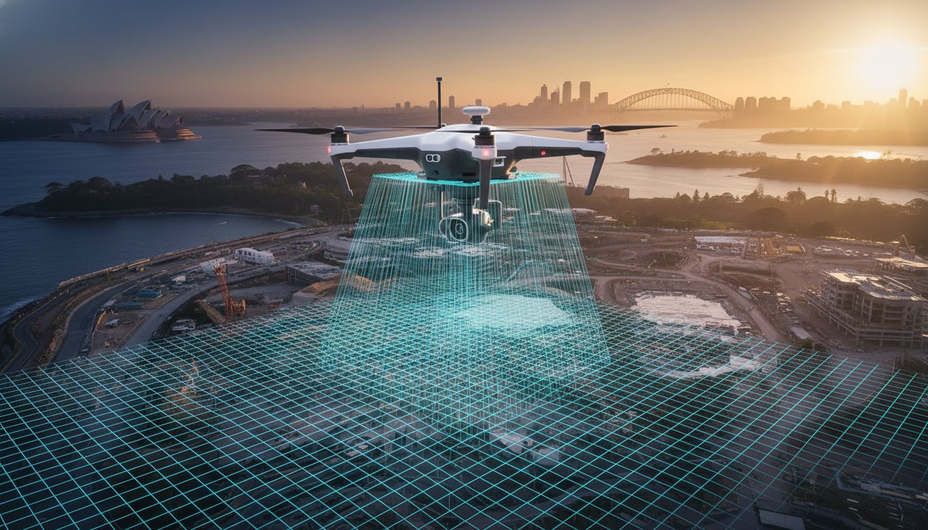
You’ve likely noticed how the rhythm of the city is changing. In 2026, the quiet hum of a drone overhead is often the sound of progress. For anyone involved in surveying for property development sydney, this year represents a definitive turning point. We’ve moved beyond the era of simple site visits. Today, the integration of high-resolution sensors and extended battery life allows for a level of detail that was once a luxury, now a standard requirement for major NSW digital twin initiatives. These government projects rely on the high-fidelity data we capture to build a living, breathing digital map of our state.
At Hill & Blume, we view this technology as a natural extension of our 90-year legacy. It isn’t about replacing the human element; it’s about giving our experts better eyes. We combine traditional integrity with these modern tools to ensure your project begins with an unmatched foundation of data. You can explore our full range of professional surveying services to see how we blend heritage with high-tech solutions. We pride ourselves on being a boutique partner that prioritizes the depth of your project over high-volume output.
What is Drone Surveying?
It’s essential to distinguish between a hobbyist’s snapshot and professional-grade data. Professional drone surveying utilizes Unmanned Aerial Vehicles (UAVs) equipped with survey-grade GPS and GLONASS systems. These aerial survey techniques involve photogrammetry, where thousands of overlapping images are stitched together to create a precise, measurable map. By 2026, these sensors have reached a resolution where every contour and feature of your land is captured with absolute fidelity. It’s a sophisticated process of turning light and distance into actionable intelligence.
The Advantages for Sydney Property Developers
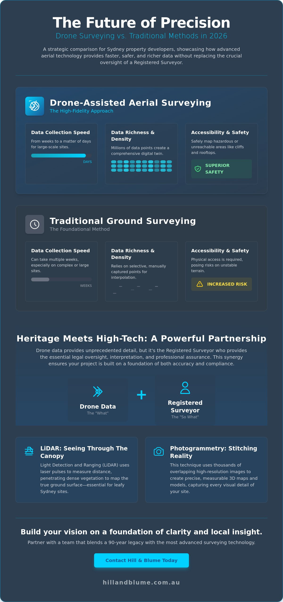
Efficiency is often the difference between a project that thrives and one that stalls. On large-scale sites across Newcastle and the Central Coast, aerial capture reduces data collection time from weeks to days. It allows us to reach the unreachable. Whether it’s the steep coastal cliffs of the Eastern Suburbs or complex urban rooftops in the CBD, we can gather data without the safety risks of physical climbing. This minimizes site downtime and keeps your team safe while providing a richer dataset than traditional methods alone could offer.
This approach transforms how you visualize your investment. You aren’t just looking at a flat plan; you’re engaging with a comprehensive digital asset. By choosing Hill & Blume, you’re partnering with a team that values the depth of your project as much as you do. We ensure that your surveying for property development sydney is handled with the care and precision your vision deserves. It’s a seamless service designed to respect your time and your intelligence.
Beyond Aerial Photography: The Science of LiDAR and Photogrammetry
You’ve likely seen the stunning aerial vistas drones can capture, but for professional surveying for property development sydney, the true value lies beneath the surface of the image. It’s a shift from visual aesthetics to raw, actionable data science. By 2026, the distinction between simple photography and precision measurement has never been clearer. We use two primary methodologies to map your vision: LiDAR and Photogrammetry. Each offers a unique perspective, ensuring that every contour of your land is documented with the care and fidelity it deserves.
As we look toward the future of drone technology, these tools have become the benchmark for sophisticated site analysis. They allow us to move beyond traditional limitations, providing a depth of relationship with the land that manual methods simply cannot match. It’s about giving you a curated experience where data meets craftsmanship.
LiDAR: Penetrating the Canopy
LiDAR, or Light Detection and Ranging, is essentially the art of measuring with light. It fires thousands of laser pulses every second, some of which find the smallest gaps between leaves and branches. This capability is vital for contour and detail surveys on undeveloped land, particularly across Sydney’s leafy North Shore. While traditional methods might struggle with dense scrub, LiDAR sensors in 2026 achieve sub-centimetre precision, filtering out vegetation to reveal the true Digital Terrain Model (DTM) hidden beneath. This level of clarity ensures your project begins on solid ground, free from the risks of unforeseen topographical surprises.
Photogrammetry and 3D Digital Twins
While LiDAR excels at finding the ground, photogrammetry is the master of texture and context. We capture thousands of overlapping, high-resolution images to construct a textured 3D mesh. This process creates a hyper-realistic “digital twin” of your site, a tool that is increasingly important when choosing between survey companies in Sydney. These models assist architects in visualizing how a structure sits within the existing environment and serve as an evocative piece of visual data for community consultations or stakeholder reviews.
The result of these combined technologies is a dense Point Cloud, a digital constellation of millions of coordinates that define your site’s exact geometry. This data doesn’t just inform your DA submission; it protects your investment by reducing project risk through better information. If you’re ready to see your site through a more precise lens, we invite you to start a conversation with our team to explore a tailored solution for your next development.
Drones vs. Traditional Land Surveying: A Strategic Comparison
Choosing the right methodology for surveying for property development sydney requires a nuanced understanding of scale and purpose. Traditional land surveying involves a skilled professional physically placing markers at specific, high-value points. It’s a method defined by targeted precision. In contrast, drone technology offers a visual feast of data, capturing millions of points in a single flight to create a dense, textured map of the entire site. The most sophisticated projects don’t choose one over the other. They utilize a hybrid approach where Ground Control Points (GCPs) act as the physical anchors, ensuring the aerial data aligns perfectly with the reality of the earth’s surface.
Cost considerations often follow the scale of the project. For a small residential lot where only a few boundary markers are needed, traditional methods remain the most efficient choice. However, as the site grows into a multi-lot subdivision or a complex commercial development, the time saved by aerial data capture often offsets the initial setup. We help you navigate these choices, offering a tailored service that prioritizes the most effective tool for your specific aspirations. It’s a considered conversation that respects both your budget and your need for absolute accuracy.
When to Choose Drone Surveying
Aerial capture shines when the canvas is large or the topography is complex. If you’re managing a major subdivision or need precise volume calculations for large-scale excavations, the speed and data density of a drone are unmatched. It’s also an elegant solution for monitoring the progress of high-rise construction set-outs, allowing project managers to visualize structural alignment against the original design in real-time. For sites where environmental impact or coastal erosion is a concern, the ability to repeat flights and compare data over time provides a powerful narrative of change.
The Irreplaceable Role of the Registered Surveyor
While technology evolves, the legal weight of a boundary remains unchanged. Drones are exceptional at mapping what is visible, but they cannot interpret the complex history of a land title. This is why registered surveyors remain the essential human filter for all property development. Only a licensed professional can legally define a boundary or sign off on the documents required for DA and CDC compliance in New South Wales. At Hill & Blume, we ensure that every byte of drone data is verified against the rigorous standards of the NSW Land Registry. We provide the signature that turns a beautiful 3D model into a legally binding document, protecting your investment with the traditional integrity our 90-year history demands.
Navigating the NSW Regulatory Landscape: CASA and Compliance
Success in surveying for property development sydney isn’t just measured in millimetres; it’s measured in adherence to the law. As the skies above our harbour city become more active, the Civil Aviation Safety Authority (CASA) has refined the framework that keeps our community safe. In 2026, operating a commercial drone is no longer a casual endeavour. It requires a deep understanding of controlled airspace, especially when your project sits in the shadow of Sydney Airport or near one of the many hospital helipads dotted across the suburbs.
You deserve the peace of mind that comes from working with a firm that treats regulatory compliance as a cornerstone of its craft. Professionalism in this field is marked by significant investment. For instance, commercial drones weighing more than 500g now require an annual registration levy of $40.00, while technical services from CASA are billed at rates between $160 and $190 per hour. These aren’t just administrative hurdles. They are the benchmarks of an industry that has matured to prioritise safety and accountability alongside technical precision.
CASA Regulations in Urban Sydney
The distinction between an “Excluded Category” flyer and a business holding a Remote Operator’s Certificate (ReOC) is critical for your project’s legal standing. While some small-scale operators fly under simpler rules, a ReOC, which typically requires a consultation investment of around $2,200, allows for more complex missions in populous areas. As of May 2026, CASA has simplified these rules, meaning operators with the right approvals no longer need separate permits to fly over populous areas, provided they maintain the standard 30-metre distance from people not involved in the operation. We handle all the intricate flight planning and local council permissions, ensuring your data capture is as seamless as it is lawful.
Data Security and Privacy Standards
In the high-density landscapes of Sydney, your site data often captures more than just boundaries. It captures a community. We take a boutique approach to data management, ensuring that faces and license plates are blurred to respect the privacy of your future neighbours. This isn’t just about good manners; it’s about strict compliance with the Privacy Act 1988. We treat your site data with the same exclusivity and care we apply to our most prestigious boundary surveys, ensuring your digital assets are protected in a digital-first era.
Hiring a firm with fully licensed and insured remote pilots is the only way to ensure your project remains above board. If you have questions about how we can safely map your next project within these complex regulations, we invite you to reach out to our professional team today.
The Hill & Blume Advantage: Heritage Meets High-Tech
The sophisticated hum of a 2026 drone is a marvel of engineering, but it’s the hand that holds the controller that truly defines the outcome. At Hill & Blume, we believe that surveying for property development sydney requires more than just high-resolution sensors; it requires the wisdom of experience. We serve as a human filter for every byte of data captured, ensuring that the digital models we produce are grounded in the physical reality of the land. You aren’t just another project in a high-volume queue. You’re a partner in a bespoke process where quality always takes precedence over quantity. This philosophy allows us to offer a calm confidence that reassures you your project is in the hands of experts who value craftsmanship.
This commitment to quality over quantity is what separates true professionals from high-volume operators. It is a standard we admire in other specialized fields, such as school photography Adelaide, where a focus on detail and customer care ensures that important memories are preserved perfectly for years to come.
Our boutique approach ensures your vision receives senior-level attention from start to finish. We don’t believe in the clinical, high-turnover model often used by larger corporate firms. Instead, we focus on the depth of our relationship with you. We seamlessly integrate aerial data into our full suite of services, from initial boundary identification to final subdivision plans. This ensures a fluid transition between the digital twin and the legal title, providing a curated experience that respects the unique charm of the properties we survey. It’s a polished service that mirrors the effortless quality you aim to provide in your own developments.
A Legacy of Accuracy Since 1932
Our story began in 1932. Since then, we’ve adapted to every technological shift, from the first optical transits to the laser-guided precision of today. The “Hill & Blume Seal” is more than a mark; it’s a promise of quality assurance built on nearly a century of practice. Interpreting drone data isn’t just about reading a point cloud. It requires deep local knowledge of Sydney’s cadastral history to ensure that new measurements respect old boundaries. We bridge that gap with ease, anchoring modern innovation to traditional integrity. Our team understands the local fabric of New South Wales, ensuring every survey is an essential part of the regional identity.
Your Partner in Property Development
We move beyond simple data collection to act as your strategic consultant. Whether you’re preparing a complex DA or navigating the requirements of the NSW Land Registry, we’re here to guide you. We act as the essential link between your architects, your builders, and the regulatory bodies, ensuring everyone speaks the same language of precision. Our communication is steady and deliberate, mimicking the pace of the high-end lifestyle our clients appreciate. If you’re ready to elevate your project with a blend of heritage and high-tech insight, we invite you to enquire about a tailored drone survey for your Sydney project. It’s a considered conversation designed to respect your intelligence and your investment.
Elevating Your Vision Through Informed Precision
The landscape of property development is a tapestry of tradition and innovation. You’ve seen how 2026 technology, from LiDAR’s canopy-penetrating lasers to hyper-realistic digital twins, provides a richer dataset than ever before. Yet, the true power of these tools is unlocked only when they’re guided by a Registered Surveyor who understands the legal weight of every boundary. Navigating the sophisticated world of surveying for property development sydney requires a partner who balances these high-tech advancements with the steady hand of experience.
Hill & Blume offers you this unique equilibrium. With over 90 years of regional expertise and a team of fully licensed CASA remote pilots, we ensure your data is as compliant as it is precise. We don’t just provide measurements; we provide a curated foundation for your project’s success. It’s time to transform your site assessments into a seamless, high-fidelity experience that respects both your timeline and your aspirations. We invite you to begin this journey with a team that values quality over volume.
Secure your project’s precision with Hill & Blume’s expert surveying services. We look forward to bringing your vision to life with the care and depth it deserves.
Frequently Asked Questions
Is drone surveying accurate enough for property boundary disputes in Sydney?
Drone data alone is generally not sufficient for resolving legal boundary disputes. While the technology provides exceptional topographical detail, the legal identification of a boundary requires ground-based verification against historical land titles. A Registered Surveyor must interpret this data to ensure it meets the strict evidentiary standards of the NSW Land Registry, protecting your interests in any formal disagreement.
Do I need to notify my neighbours before a drone survey is conducted?
While CASA regulations don’t strictly require neighbour notification for all flights, we consider it a vital part of our boutique service. Informing the local community is a mark of courtesy that maintains the harmony of your neighbourhood. We take great care to manage our flight paths and data processing to ensure the privacy of surrounding residents is respected throughout the survey.
How much time does a drone survey save compared to traditional methods?
Utilising drones for surveying for property development sydney can reduce data collection time by up to 80% on expansive or difficult sites. What might take a ground crew several days to map can often be captured in just a few hours. This efficiency allows for faster site assessments, ensuring your DA submission remains on schedule while providing a significantly denser dataset.
Can drones survey land that is covered by heavy trees or bushland?
Yes, drones can effectively map vegetated areas if they are equipped with LiDAR technology. Unlike standard photogrammetry, LiDAR pulses can penetrate small gaps in the canopy to reach the forest floor. This capability allows us to create highly accurate Digital Terrain Models even in the leafiest parts of the North Shore or on undeveloped bushland sites across New South Wales.
Are drone surveys legal to perform near Sydney Airport or the CBD?
It is entirely legal, provided the operation is managed by a licensed firm with the necessary CASA approvals. Flying in restricted airspace requires sophisticated flight planning and often involves direct coordination with aviation authorities. We handle these complex logistics on your behalf, ensuring your urban project remains fully compliant with federal safety laws while capturing the data you need.
What kind of deliverables will I receive from a drone survey?
You’ll receive a curated suite of digital assets designed for seamless integration into your project’s workflow. Common deliverables include high-resolution orthomosaic maps, 3D point clouds, and textured 3D meshes. These files are typically provided in formats like PDF, CAD, or LAS, allowing your architects and engineers to work with a precise digital twin of the site.
Do I still need a Registered Surveyor if I have a drone map of my property?
A Registered Surveyor is essential for any data that informs a legal title or building set-out. While a drone map provides a stunning visual and data-rich overview, it lacks the legal weight required for DA or CDC compliance. Our professionals provide the necessary “human filter” and legal signature, ensuring your surveying for property development sydney is both technically brilliant and legally binding.
What happens if the weather is poor on the day of the scheduled flight?
We monitor local weather patterns closely and will postpone a flight if conditions like high winds or rain compromise safety or data quality. Your project’s accuracy is our priority, and we don’t believe in rushing a flight at the expense of precision. If a delay occurs, we’ll reschedule promptly to ensure your data is captured in the best possible light.
Disclaimer
The information provided in articles published on this website is for general informational purposes only. While we make every effort to ensure the accuracy, completeness, and timeliness of the content, the material is based on our understanding of the industry at the time of writing and may not reflect the most current developments, regulations, or standards. All opinions expressed in our articles are those of the respective authors and do not necessarily represent the official position of the website or its affiliates. The content should not be considered professional, legal or technical advice, and should not be relied upon as a substitute for consultation with qualified professionals