

Imagine the quiet tension on a Sydney job site when a structural foundation is poured, only to discover it’s thirty millimetres out of alignment with the approved plans. You know that in the world of civil infrastructure, precision isn’t just a goal; it’s the very heartbeat of a successful build. Partnering with a skilled construction surveyor for civil works is the most effective way to protect your project from these costly set-out errors. Since 1932, Hill & Blume has acted as a specialized local authority, ensuring that every mark on the ground reflects the craftsmanship and care your vision requires.
We understand the pressure of meeting the strict 2024 Surveying and Spatial Information Regulation while managing tight project timelines. You deserve a partnership that prioritizes depth of relationship over high-volume turnover, providing you with the calm confidence that your WAE reporting and digital plan lodgements are handled with meticulous care. This article explores how expert civil surveying ensures seamless council approvals and mitigates risk across Sydney’s landscape. We’ll look at the technical requirements for modern infrastructure and how a boutique approach creates a foundation for long-term project success.
Key Takeaways
- Understand how a construction surveyor for civil works translates complex digital engineering models into a precise physical framework for Sydney’s infrastructure.
- Discover why meticulous construction set-outs and detail surveys are essential for mitigating project risks and avoiding expensive site delays.
- Navigate the evolving NSW regulatory landscape by mastering the requirements for Work-as-Executed (WAE) surveys and digital plan lodgements.
- Learn how to identify a reliable surveying partner by prioritizing Registered Surveyor status and a deep understanding of local urban constraints.
- Explore the benefits of a boutique partnership that combines nearly a century of Sydney heritage with the latest in Building Information Modelling (BIM).
The Vital Role of a Construction Surveyor in Civil Works
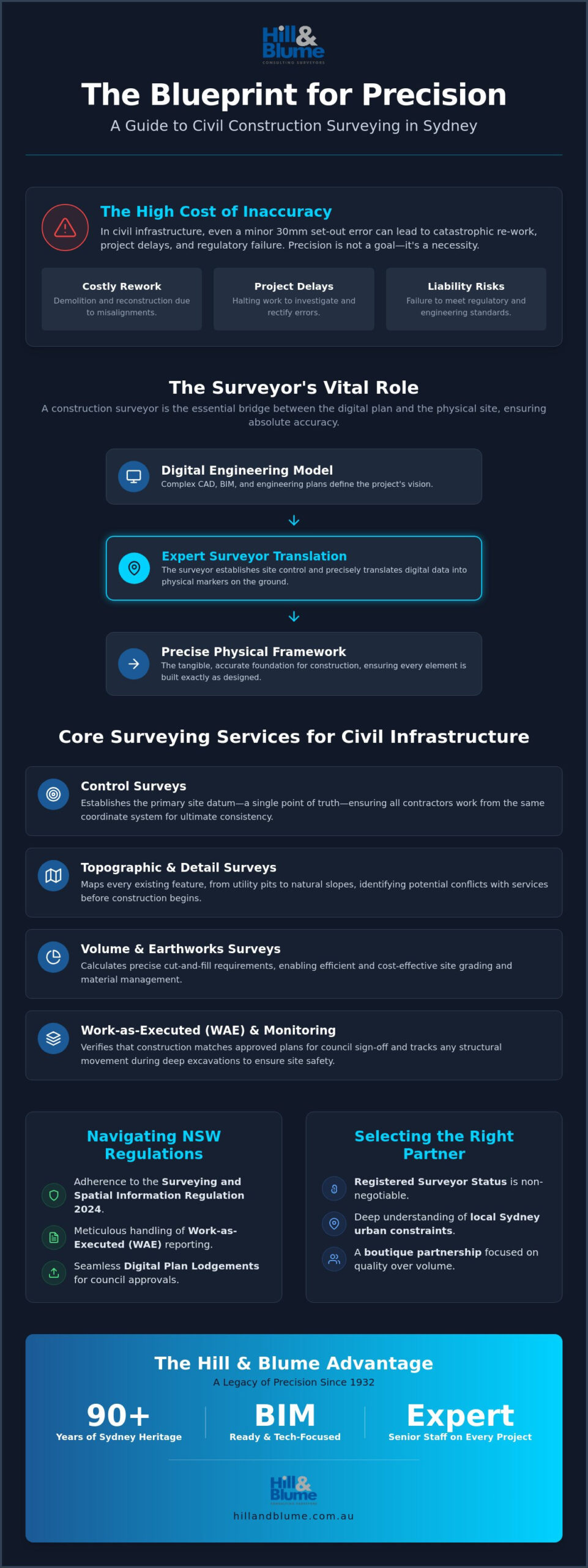
Civil infrastructure is the silent architecture of our lives. From the roads that carry us home to the utilities hidden beneath our feet, every element relies on a foundation of absolute accuracy. A construction surveyor for civil works acts as the essential architect of this spatial truth. They provide the framework that ensures every bridge pier and drainage pipe sits exactly where the engineers intended. Construction surveying is the vital bridge between a digital engineering model and the physical reality of a Sydney job site. Without this precise translation, the risk of structural misalignment or regulatory failure becomes an expensive reality. In large-scale civil projects, even a minor deviation can lead to catastrophic re-work, making precision a non-negotiable standard for every stakeholder involved.
Defining Civil Construction Surveying
While residential surveying often focuses on the quiet boundaries of a private home, civil works demand a different level of intensity. It’s about scale and complexity. A construction surveyor for civil works establishes the “Control Survey,” which serves as the primary site datum. This single point of truth ensures that every contractor on-site is working from the same coordinate system. It’s a sophisticated intersection of land law and engineering measurement. Our team at Hill & Blume works closely with civil engineers and project managers to ensure that high-stakes infrastructure remains compliant with the latest NSW regulations, such as the Surveying and Spatial Information Regulation 2024. You can explore our full range of professional services to see how we integrate these standards into our boutique workflow.
Risk Mitigation Through Early Involvement
Success in civil construction is often decided before the first shovel hits the ground. By engaging a Registered Surveyor early, you identify site constraints that might otherwise lead to costly re-work. Detailed topographic mapping in the pre-design phase uncovers the nuances of Sydney’s unique geology and urban layout. This isn’t just about measurement; it’s about reducing your project’s liability. When you have accurate spatial data from the outset, you’re not just building; you’re protecting your investment. We view this as a partnership. It’s a commitment to quality over quantity, ensuring that your infrastructure project stands as a testament to precision and craftsmanship for decades to come. Our boutique approach ensures that senior expertise is present at every stage, providing the calm confidence needed to navigate complex site variables.
Core Surveying Services for Civil Infrastructure
Every successful civil project begins with a deep understanding of the land’s existing contours. A professional construction surveyor for civil works provides the essential data that transforms a conceptual sketch into a buildable reality. This process often starts with Topographic and Detail Surveys, which map every existing feature from utility pits to natural slopes. In the dense urban environment of Sydney, these surveys are critical for identifying potential conflicts with existing services before construction commences. By adhering to the high standards set by the Institution of Surveyors NSW, our team ensures that every measurement is backed by professional integrity and technical excellence.
Beyond initial mapping, civil infrastructure requires continuous spatial management. Volume and Earthworks Surveys allow project managers to calculate precise cut-and-fill requirements, ensuring site grading is both efficient and cost-effective. Monitoring Surveys play an equally vital role, tracking ground shifts or structural movement during deep excavations. This proactive approach protects not only your project but also the surrounding community and adjacent properties. To complement these spatial monitoring efforts, many civil projects also utilise Jobcam for 24/7 solar-powered surveillance to ensure site security is maintained alongside technical accuracy. It’s a level of care that distinguishes a boutique firm from a high-volume agency.
Construction Set-out for Precision
The transition from a digital CAD design to a physical site marker is a moment where there is no room for error. We specialise in translating complex engineering models into tangible site markers with millimetre accuracy. This includes the precise placement of stormwater systems, sewerage lines, and road alignments. For a deeper look at how this process ensures your project remains within legal and engineering tolerances, you may find our article on Construction Set-out in Sydney: A Guide to Precision and Compliance particularly useful. It highlights the intersection of technical skill and regulatory necessity.
Monitoring and Earthworks Analysis
Modern civil works demand more than just static points on a map. We utilise 3D data to calculate stockpile volumes and monitor excavation progress in real-time. This data-driven approach ensures that the project stays within the vertical and horizontal tolerances defined in the design phase. Rigorous vibration and movement monitoring are also employed to safeguard nearby structures, a necessity when working within Sydney’s unique geological constraints. If you’re planning a complex civil project and require this level of detail, you might consider discussing your requirements with one of our Registered Surveyors to ensure a seamless start to your build.
Our commitment to precision is reflected in our comprehensive suite of services, each tailored to the specific needs of Sydney’s infrastructure landscape. By choosing a partner who values quality over quantity, you ensure that your project is built on a foundation of trust and technical mastery.
Technology and Compliance: The NSW Regulatory Landscape
Completing the physical build of a road or bridge is only half the journey. In the sophisticated regulatory environment of New South Wales, the transition from construction to asset handover requires a meticulous digital paper trail. As of July 1, 2026, the mandate for digital plan lodgement has transformed how we interact with NSW Land Registry Services. This shift requires every construction surveyor for civil works to be proficient in creating Stage 1 LandXML files and utilizing the Online Form Builder for all deposited plans. It’s no longer enough to simply measure; a surveyor must now act as a digital custodian, ensuring that every piece of infrastructure is recorded with the precision required by the Surveying and Spatial Information Regulation 2024.
Whether you’re working under the stringent requirements of Transport for NSW or a local Sydney council, compliance is the seal of quality that allows a project to be finalized. We understand that you value a partnership where these technical hurdles are handled with calm confidence. Our boutique approach ensures that your project meets every environmental and safety standard, leveraging our 90 years of local heritage to provide a seamless path to project completion. You can view our specialized Work-as-Executed (WAE) services to see how we manage these high-stakes submissions.
Work-as-Executed (WAE) Surveys
The Work-as-Executed survey is the final truth of a civil project. It serves as a formal verification that the constructed assets align perfectly with the approved engineering designs. For developers in Sydney, these reports are the critical gatekeepers for the release of subdivision certificates. A common pitfall in this phase is the discovery of minor deviations that weren’t documented during construction, which can lead to frustrating delays in council handover. By maintaining a steady rhythm of data capture throughout the build, we ensure that your WAE submission is accurate the first time, avoiding the administrative friction that often plagues larger, more clinical agencies.
Modern Tech: Laser Scanning and BIM
Modern infrastructure demands a modern toolkit. We utilize high-definition 3D laser scanning to capture “As-Built” data in real-time, creating a comprehensive digital twin of your civil assets. This data doesn’t just sit in a file; it’s integrated into Building Information Modelling (BIM) workflows, providing a foundation for the entire lifecycle management of the project. To maintain the precision required for these advanced workflows, ensuring that measurement tools are properly serviced by experts like zenithinstruments.com.au is essential. For large-scale civil site inspections, drone surveying offers a rapid and safe method for mapping terrain that would otherwise be inaccessible. This intersection of craftsmanship and technology ensures that your project is not only built for today but is also digitally prepared for the future of Sydney’s infrastructure.
Selecting the Right Surveyor for Your Civil Project
Choosing a construction surveyor for civil works is one of the most critical decisions in the lifecycle of an infrastructure project. It’s a choice that moves beyond simple procurement into the territory of strategic partnership. You need a team that doesn’t just provide data but offers a sense of calm confidence amidst the complexities of a Sydney job site. This selection process requires a discerning eye for both technical capability and local heritage, ensuring your chosen partner is as detail-oriented as the project demands.
When evaluating a firm, consider these essential criteria to ensure a seamless project flow:
- Technical Compatibility: Ensure their equipment and data formats integrate perfectly with your engineering software, specifically regarding the 2026 LandXML requirements.
- Response Agility: Assess their capacity for ongoing site support. Civil projects are dynamic; you need a partner who can provide rapid set-out adjustments without stalling your crew.
- Boutique Service: Prioritize firms that offer a direct line to senior Registered Surveyors rather than high-volume corporate turnover.
The Registered Surveyor Advantage
In New South Wales, the title “Registered Surveyor” isn’t merely a credential; it’s a legal safeguard. Only these professionals have the authority to define land boundaries, which is essential for any civil works that interface with property lines or public easements. This status brings a high level of accountability and professional indemnity that protects your investment. If you’re curious about the specifics of this role, our guide on what is a Registered Surveyor in NSW provides a comprehensive look at why this is the essential standard for 2026 projects.
Local Knowledge and Heritage
Sydney’s urban landscape is a tapestry of historical records and unique geological constraints. A firm anchored by over 90 years of local records, such as Hill & Blume, brings a library of knowledge that a newer agency simply cannot replicate. We’ve navigated the specific requirements of councils across Sydney, Newcastle, and the Central Coast for decades. This deep-rooted identity allows us to anticipate challenges before they arise, moving smoothly from initial aspirations to tailored solutions. For more insights on evaluating potential partners, explore our Choosing a Surveyor in Sydney: The 2026 Professional Buying Guide.
The best partnerships are built on technical mastery and a shared commitment to quality. If you’re ready to secure a boutique partner who values depth of relationship over high turnover, we invite you to contact our team of Registered Surveyors today to discuss how we can support your upcoming civil project with precision and care.
Partnering with Hill & Blume for Civil Excellence
Hill & Blume represents a legacy of precision that spans nearly a century. Choosing a construction surveyor for civil works is about more than just modern equipment; it’s about the heritage of the firm and the integrity of the individuals on-site. Since 1932, we’ve supported developers and civil contractors across the Sydney basin, providing the technical foundation for projects that shape our regional identity. Our boutique structure ensures that you aren’t just another project number in a corporate database. Instead, you’re a valued partner who receives direct access to senior expertise and a hand-crafted approach to spatial data.
Our commitment to excellence remains steady from the initial site set-out to the final Work-as-Executed (WAE) submission. We understand that in the high-stakes world of civil infrastructure, delays are costly and compliance is non-negotiable. By blending 90 years of local records with modern 3D laser scanning and BIM integration, we provide a level of care that prioritizes both your project timelines and the strict regulatory standards of NSW. It’s a partnership-oriented narrative that values quality over quantity, ensuring every mark on the ground is a testament to our shared community values.
Our Civil Surveying Process
We’ve refined our workflow to be as seamless as the infrastructure you build. Every engagement begins with a detailed consultation to align our spatial strategy with your specific engineering requirements. We don’t just hand over raw data; we deliver it in curated formats that suit your existing CAD and BIM environments, ensuring no friction during the design or construction phases. Throughout the project lifecycle, a dedicated project manager maintains consistency, providing a steady rhythm of communication that keeps your team informed and your project on track. This deliberate pace respects your time and intelligence, moving smoothly from identifying your aspirations to offering a tailored solution.
Get Started with a Professional Consultation
Securing a reliable partner for your next build is a straightforward process. We provide detailed fee proposals tailored to the unique constraints of your site, whether you’re working in the heart of Sydney, the growing corridors of Newcastle, or the coastal landscapes of the Central Coast. Our team is ready to offer the calm confidence you need to navigate the 2026 regulatory environment with ease. To explore how our registered surveyors can elevate your next project, we invite you to view our full range of professional surveying services and discover the Hill & Blume difference.
Building the Future of Sydney on a Foundation of Precision
Precision in civil infrastructure is more than a technical requirement; it’s a commitment to the longevity and safety of our shared urban landscape. Throughout this guide, we’ve explored how the right spatial framework mitigates risk and ensures that complex designs are translated accurately into physical reality. From navigating the latest NSW regulations to mastering the nuances of digital plan lodgements, the role of a construction surveyor for civil works is indispensable to project success.
By choosing a boutique partner with over 90 years of Sydney experience, you gain the calm confidence that comes from working with a team of Registered Surveyors who specialise in meticulous construction set-out and WAE reporting. We invite you to experience a service where senior expertise and traditional integrity meet modern technology. Your vision deserves the care and craftsmanship that only a deeply rooted local authority can provide. It’s about building a partnership that values the human element of every project as much as the measurements themselves.
Partner with Sydney’s Trusted Civil Surveyors to ensure your next infrastructure project is built with absolute certainty and professional excellence.
Frequently Asked Questions
What is the difference between a land surveyor and a construction surveyor?
A land surveyor defines legal boundaries and titles, whereas a construction surveyor for civil works focuses on the physical placement of infrastructure according to engineering designs. While both roles demand high precision, the construction surveyor’s primary task is translating digital models into real-world markers. This ensures that every element, from drainage pits to road alignments, is positioned correctly within the site’s spatial framework.
Why do I need a Work-as-Executed (WAE) survey for my civil project?
You need a Work-as-Executed (WAE) survey to verify that your finished infrastructure aligns perfectly with the approved engineering plans. These reports are essential for council handover in Sydney and the subsequent release of subdivision certificates. Without an accurate WAE report, you risk significant delays in project finalization and asset acceptance by local authorities or Transport for NSW.
Is a Registered Surveyor required for civil infrastructure works in NSW?
A Registered Surveyor is mandatory in NSW for any civil infrastructure project that interacts with property boundaries or easements. Following the 2024 regulations, any survey depicting boundary information is formally considered a land survey. This requirement ensures that a qualified professional takes legal responsibility for the accuracy of the data, providing a seal of quality for both developers and local councils.
How often should a surveyor visit a civil construction site?
Surveyor site visits should align with your major construction milestones, such as the commencement of excavation or the pouring of structural foundations. Regular attendance ensures that markers remain accurate and that any site shifts are identified early. For high-stakes civil projects, a steady rhythm of site visits helps maintain design tolerances and provides the calm confidence that the build is progressing exactly as planned.
Can a surveyor help with earthworks volume calculations?
Yes, we use sophisticated 3D data capture to calculate precise earthworks volumes for site grading and excavation. By comparing the existing terrain with your proposed engineering design, a construction surveyor for civil works can determine exact cut-and-fill requirements. This data-driven approach helps you manage stockpile volumes and disposal costs while ensuring the site remains within vertical and horizontal tolerances.
What technologies do Hill & Blume use for civil surveying in 2026?
In 2026, we leverage high-definition 3D laser scanning, drone mapping, and GNSS technology to capture site data with millimetre accuracy. Our workflow is fully integrated with Building Information Modelling (BIM) and complies with the mandatory NSW digital plan lodgement requirements, including LandXML files. This modern toolkit allows us to provide a digital twin of your assets for long-term lifecycle management.
How do construction set-out surveys prevent project delays?
Construction set-out surveys prevent delays by providing your site crew with millimetre-accurate markers before any physical work begins. When every pipe, kerb, and pit is placed correctly the first time, you eliminate the need for expensive re-work. This proactive approach ensures that the project moves smoothly toward council approval, avoiding the administrative friction caused by non-compliant structures.
What areas do Hill & Blume cover for civil surveying services?
Hill & Blume provides expert civil surveying services across Greater Sydney, Newcastle, and the Central Coast. Our 90 years of experience in these regions give us a unique understanding of local council requirements and regional geology. Whether you’re developing in the urban heart of Sydney or along the coastal corridors, we provide a boutique, relationship-oriented service tailored to your project’s needs.
Disclaimer
The information provided in articles published on this website is for general informational purposes only. While we make every effort to ensure the accuracy, completeness, and timeliness of the content, the material is based on our understanding of the industry at the time of writing and may not reflect the most current developments, regulations, or standards. All opinions expressed in our articles are those of the respective authors and do not necessarily represent the official position of the website or its affiliates. The content should not be considered professional, legal or technical advice, and should not be relied upon as a substitute for consultation with qualified professionals