
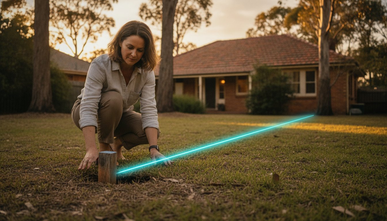
A single weathered peg buried beneath years of garden growth holds more legal significance than any handshake or visual estimate. You have likely stood at the edge of your garden, plan in hand, feeling the quiet weight of uncertainty about where your private sanctuary truly ends. It is a natural concern for any homeowner who values the integrity of their land and the harmony of their neighbourhood. Finding property boundary pegs nsw is often a search for history, yet it remains a vital step in ensuring your future projects stand on solid legal ground.
We understand that navigating old survey plans and overgrown corners can feel overwhelming. In this guide, you will discover the professional techniques for locating your markers and learn exactly when the law requires the precision of a registered surveyor to protect your investment. We will walk through the physical search process, explain the implications of the Surveying and Spatial Information Regulation 2024, and ensure you have the clarity needed to move forward with absolute confidence.
Key Takeaways
- Learn how the evolution of marker materials influences your search and why these physical points are the foundation of your land’s legal identity.
- Discover how digital tools and careful site preparation can simplify the process of finding property boundary pegs nsw on your own.
- Understand your legal responsibilities under the latest regulations to avoid the severe penalties associated with interfering with official survey marks.
- Recognize the specific project milestones, from fencing to council applications, that require the precision of a professional re-establishment survey.
- Explore how the NSW cadastre and Deposited Plans work together to define the unique footprint of your home within the local landscape.
What Are Property Boundary Pegs and Why Are They Missing?
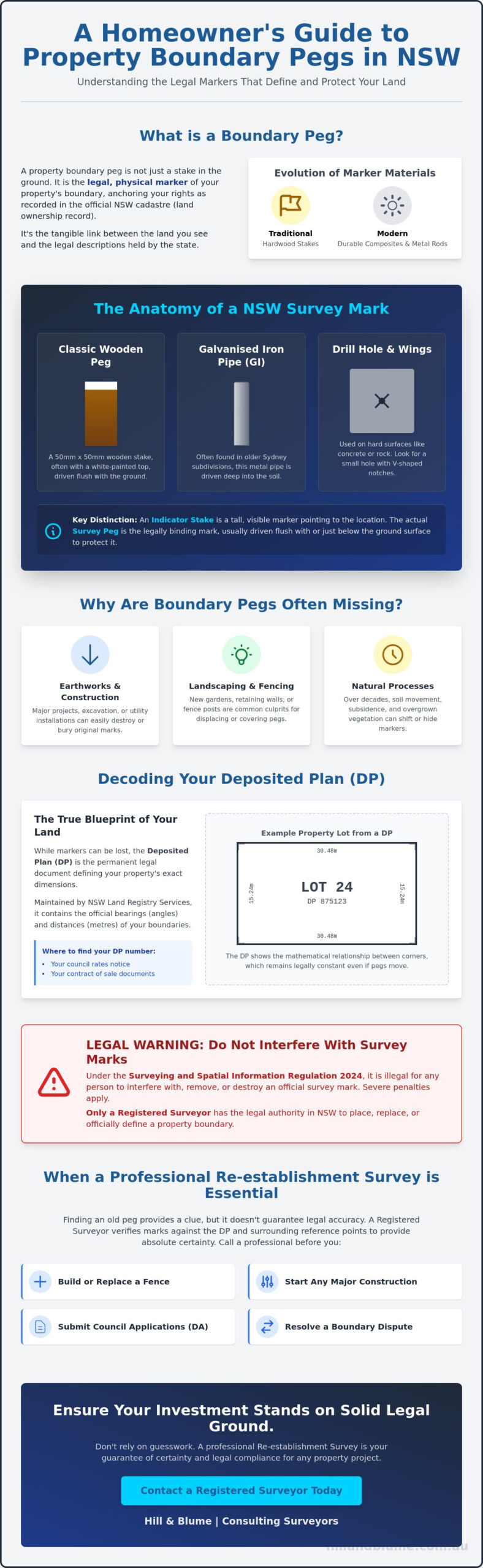
A property boundary peg is more than a simple stake in the ground; it’s a legal physical marker of the cadastre, the official record of land ownership. When you are finding property boundary pegs nsw, you are essentially looking for the physical anchor of your property rights. These markers serve as the tangible link between your physical garden and the abstract legal descriptions held by the state. Over decades, the materials used for these markers have evolved significantly. While you might find traditional hardwood stakes on older parcels, modern surveyors often utilize durable composite materials or metal to ensure longevity.
The history of Surveying in Australia is deeply rooted in the Torrens Title system, which relies on these precise points to define where one person’s dream ends and another’s begins. However, finding property boundary pegs nsw can be challenging because pegs often “disappear.” Common culprits include major earthworks, enthusiastic landscaping, or the slow, natural process of soil subsidence. It’s also vital to distinguish between a tall “indicator stake,” which is meant to be seen, and the actual survey peg, which is typically driven flush with the ground to maintain its position.
The Anatomy of a NSW Survey Mark
In New South Wales, the classic survey peg is a 50mm x 50mm wooden stake, often finished with a white-painted top to help it stand out against the earth. If your property is in an older Sydney subdivision, you might instead find a “GI,” which is a galvanised iron pipe driven deep into the soil. In areas where the boundary falls on concrete or stone, look for more subtle signs. Surveyors often use “drill holes and wings,” which are small holes accompanied by V-shaped notches carved into the hard surface. These marks are permanent, discreet, and legally binding.
Why Finding One Peg Isn’t Always Enough
Locating a single peg provides a starting point, but it rarely tells the whole story. Boundaries are defined by lines, and a line requires at least two points to establish a “bearing” or direction. Beyond this, pegs can be “disturbed” by tree roots or construction, shifting several centimetres over time. Professional surveyors rely on “Reference Marks” placed safely away from the actual boundary corners. These benchmarks allow us to verify that the pegs you see haven’t moved. If you find yourself unsure of your markers’ accuracy, our team offers specialized boundary surveys to provide the absolute certainty your property deserves.
The NSW Cadastre: How Your Property is Recorded
Your property doesn’t exist in isolation. It’s a carefully defined parcel within the NSW cadastre, a comprehensive public record of land boundaries. While your Title Deed confirms your ownership, it’s the Deposited Plan (DP) that serves as the ultimate legal source for your land’s dimensions. This plan is more than a simple map. It’s a legal document that ensures your neighbor’s fence doesn’t quietly encroach upon your sanctuary. The NSW Land Registry Services (LRS) maintains this integrity, acting as the custodian of the state’s boundary fabric.
Surveyors perform a delicate task often described as “stitching.” They take historical records, modern measurements, and surrounding parcel data to ensure every lot fits perfectly without overlaps or gaps. This is why your deed refers to a plan number rather than just physical landmarks. Markers can be moved or lost, but the mathematical relationship recorded in the DP remains constant. Finding property boundary pegs nsw requires a blend of physical investigation and archival research. When you’re finding property boundary pegs nsw, you’re looking for the physical manifestation of these digital and paper records. It’s a search for the truth as recorded by the state.
Reading Your Deposited Plan (DP)
To find your DP number, look at your most recent rates notice or your contract of sale. Once you have the plan, you’ll see lines marked with bearings and distances. Bearings represent the angle of the line relative to north, while distances are recorded in metres. Modern plans often include Map Grid of Australia (MGA) coordinates. These allow for satellite-precision positioning that transcends simple tape measurements. Understanding these figures is the first step toward visualizing your property’s true footprint before you even step outside.
The Role of the Registered Surveyor in NSW
In New South Wales, the law is clear. Only a Registered Surveyor has the legal authority to define a boundary. This exclusivity ensures that the cadastre remains accurate and indisputable for generations to come. Under the Surveying and Spatial Information Act 2002, surveyors must adhere to rigorous precision standards that protect your land’s value. At Hill & Blume, we draw upon over 90 years of local records in Sydney to provide this certainty. Our specialized boundary surveys bridge the gap between old paper records and your modern landscape. If you need a definitive answer regarding your land’s edge, we invite you to speak with our team about a professional assessment.
Practical Steps: How to Safely Search for Your Boundary Pegs
Before you pick up a shovel, begin your search in the digital space. Finding property boundary pegs nsw starts with a sophisticated understanding of your lot’s orientation before you even step onto the lawn. By blending modern spatial tools with traditional detective work, you can often narrow your search to a few square centimetres of earth. This process requires patience and a gentle touch, as the goal is to uncover history without disturbing the very markers that define your land.
Using NSW Six Maps for Context
The official NSW spatial portal, known as Six Maps, is an invaluable resource for homeowners. By accessing the “Lot Boundaries” layer, you can visualize how your property sits in relation to the street and your neighbors. You can use the measurement tool to estimate distances from the kerb or the intersection of your street. It’s vital to remember that these digital maps are indicative only. They offer a helpful visual guide, but they are not legally binding documents and should never replace a professional survey for construction purposes.
The Metal Detector Technique
Many survey marks in Sydney are capped with metal or consist of galvanised iron pipes (GIs) driven deep into the ground. A high-quality metal detector becomes an essential tool in these instances, especially when markers are buried under layers of topsoil or leaf litter. You’ll need to distinguish between a genuine survey mark and common utility pipes or stray garden stakes. A survey nail embedded in a concrete driveway typically produces a sharp, high-pitched resonance that distinguishes it from the duller thud of underlying rebar. Once you receive a clear signal, carefully clear the area with a hand trowel rather than a heavy spade.
The Danger of DIY Measurements
The most common mistake homeowners make is assuming that an existing fence sits exactly on the boundary line. Fences are often built for convenience or to avoid obstacles like tree roots; they are rarely perfect legal indicators. In older Sydney subdivisions, you may encounter the “cumulative error” problem. This occurs when small discrepancies in successive lot measurements over a century lead to significant shifts at the end of a block. Relying on your own tape measure to find a corner can inadvertently lead to costly disputes. To truly protect your property’s integrity, learn more about our Boundary Surveys in Sydney before making any permanent changes to your land.
Once you believe you’ve located a peg, document your find immediately. Take clear, high-resolution photos from multiple angles, including “pull-back” shots that show the peg in relation to permanent structures like your house or the street. Measure the distance from the peg to at least two fixed points on your home and record these in a safe place. This personal record-keeping provides a wonderful baseline, though it remains a private reference rather than a legal certification.
Legal Consequences: What You Cannot Do with Survey Marks
While your search for property markers is a practical endeavor, it is governed by strict legislative frameworks. The Surveying and Spatial Information Act 2002 and the accompanying 2024 Regulation establish the legal sanctity of every peg, nail, and drill hole used to define the cadastre. Finding property boundary pegs nsw is a right you have as a homeowner, but it comes with a significant responsibility. These marks aren’t merely suggestions; they’re the physical evidence of the state’s land title system. Understanding the weight of these markers is essential before you begin any landscaping or construction project.
It’s a criminal offence to remove, damage, or interfere with a survey mark in New South Wales. The law treats these markers as vital public infrastructure. For the 2025-2026 financial year, the maximum penalty for such interference is 50 penalty units, which equates to a fine of $6,165.50. This isn’t just a regulatory hurdle. It’s a protection meant to prevent the chaos of shifting boundaries. If a contractor or fencer accidentally disturbs a mark during their work, they have a professional duty of care to report it immediately. Ignoring a disturbed peg doesn’t make the problem go away; it only defers a potentially expensive legal correction.
Penalties and Liabilities
The financial sting of a fine is often just the beginning. The real risk lies in civil liability. If you build a retaining wall or a garage based on a peg that’s been moved, you’re legally responsible for the encroachment. This can lead to expensive demolition orders or complex legal battles that significantly devalue your property during a sale. A “clean” title is a hallmark of a premium property, and any boundary dispute acts as a stain that savvy buyers will avoid. Finding property boundary pegs nsw accurately is the only way to ensure your property’s value remains unclouded by future claims.
The Encroachment Act 1938
When a structure crosses the boundary line, the Encroachment Act 1938 dictates the resolution process. The NSW Land and Environment Court has the power to order the removal of the structure or mandate compensation to the affected neighbour. To avoid these high-stakes scenarios, we recommend commissioning an Identification Survey. This document provides a professional certification of where your structures sit in relation to the legal boundaries. If you suspect a marker has been compromised, it’s best to consult with a registered surveyor before proceeding with any construction or fencing work.
When to Call Hill & Blume for a Re-establishment Survey
While finding property boundary pegs nsw is a satisfying weekend project, a physical find is only half the story. There is a profound difference between spotting a weathered marker in the garden and having a legally certified boundary. A re-establishment survey is the definitive act of translating historical records into your modern landscape with absolute precision. It’s the moment where “I think this is the corner” becomes “I know this is the boundary.”
You should consider a professional survey at several critical milestones of property ownership. If you’re building a new fence on a shared line, a re-establishment ensures you aren’t inadvertently gifting your land to a neighbor or encroaching on theirs. Similarly, before submitting a Development Application (DA) to your local Sydney council, a formal survey is often a non-negotiable requirement. It protects your investment from the start. If a neighbor disputes a boundary or if you are purchasing a property and want to verify the land area, our team provides the clarity needed to move forward without hesitation.
The Re-establishment Process
Our approach blends advanced technology with deep archival research. We utilize high-precision robotic total stations and GNSS technology to achieve millimetre accuracy across your lot. However, the most vital work often happens in our office. We extract historical Deposited Plans and field notes from our 90-year archive to understand the context of your land. This research allows us to place new, durable marks that are legally compliant and “certified.” Finding property boundary pegs nsw through our professional lens ensures that every marker we place is anchored in both the earth and the law.
Peace of Mind for Your Property Investment
The value of a professional survey extends far beyond the physical pegs. A signed Survey Report acts as a seal of quality for your bank, solicitor, or future buyer. It’s a document that confirms your property’s integrity and protects its market value. At Hill & Blume, our reputation for precision is why we are trusted by Sydney’s leading architects and developers. We don’t just measure lines; we provide the confidence you need to enjoy your home. If you’re ready to secure your property’s future, Contact Hill & Blume for a professional boundary survey quote and experience a service tailored to your land’s unique story.
Clarity for Your Next Chapter
Your property is more than a parcel of land; it is the foundation of your lifestyle and a significant family asset. While the process of finding property boundary pegs nsw can begin with a curious search in the garden, true peace of mind comes from knowing exactly where your legal rights reside. You now understand that these markers are not just physical objects, but legal anchors protected by rigorous NSW regulations. Whether you are planning a new boundary fence or preparing a complex development application, the precision of your boundaries is the cornerstone of a successful project.
At Hill & Blume, we’ve dedicated over 90 years to defining the Sydney landscape with unwavering accuracy. Our registered surveyors combine deep regulatory expertise with sophisticated robotic technology to ensure your land is protected for generations. We invite you to secure your property boundaries with a professional survey from Hill & Blume. It’s a simple step that offers lasting confidence in the integrity of your home. We look forward to partnering with you to bring absolute certainty to your land.
Common Questions Regarding Your Property Markers
Is it illegal to pull up a survey peg in NSW?
Yes, it is a criminal offence to remove, damage, or interfere with any survey mark in New South Wales. Under the Surveying and Spatial Information Act 2002, these markers are protected as vital public infrastructure. For the 2025-2026 financial year, the maximum penalty for such interference is $6,165.50. If you accidentally disturb a mark, you should contact a registered surveyor immediately to have it professionally reinstated.
How much does it cost to have a surveyor find my boundary pegs in Sydney?
The investment required for a professional survey depends on several unique factors related to your land. The age of your subdivision, the complexity of the local terrain, and the availability of historical survey evidence all play a role in the final assessment. Older areas often require more extensive archival research to ensure accuracy. We recommend requesting a tailored quote to understand the specific requirements for your property’s unique footprint.
Can I use a metal detector to find my property pegs?
You can certainly use a metal detector as a helpful preliminary tool for finding property boundary pegs nsw. This technique is particularly effective for locating “GIs” or galvanised iron pipes and survey nails that have been buried by topsoil or garden mulch over time. While this can provide you with personal clarity, remember that a DIY find doesn’t hold legal weight for construction or fencing purposes without a surveyor’s certification.
What do the different colors on survey pegs mean?
White is the traditional and standard color for permanent boundary pegs in New South Wales. You may also notice markers adorned with pink or orange tape; these are typically “indicator” marks used by surveyors to show a line of sight or a temporary point of interest. Blue markers are often used to denote water-related infrastructure or specific utility points. Always look for the physical peg or drill hole rather than just the color of the tape.
My neighbor moved the survey peg, what should I do?
If you suspect a marker has been moved, it’s vital that you don’t attempt to move it back yourself. This can lead to legal disputes and potential fines for both parties involved. Instead, engage a registered surveyor to perform an Identification Survey. This professional report will provide an indisputable, legally binding record of the boundary, allowing you to resolve the matter with calm confidence and factual evidence.
How long do survey pegs stay in the ground before they need re-establishing?
The lifespan of a survey mark varies based on the material used and the environment of your garden. Traditional hardwood pegs can last for decades, though they’re eventually susceptible to rot or termites. Modern composite or metal markers are designed for much greater longevity. However, a re-establishment survey is often necessary regardless of age if there’s been significant soil movement, tree root growth, or nearby construction that might have shifted the markers.
Do I need a survey if there is already an existing fence?
An existing fence is often an unreliable indicator of your true legal boundary. Many fences in Sydney’s older suburbs were built for convenience or to avoid natural obstacles rather than following the exact line of the cadastre. Relying on a fence for a new building project can lead to costly encroachment issues. A professional survey ensures that your new structures sit firmly within your own sanctuary, protecting your long-term property value.
What is the difference between a boundary peg and a reference mark?
A boundary peg is placed exactly on the corner or the bend of your property line to define the extent of your land. A reference mark is a secondary, permanent point—often a drill hole in a concrete kerb or a nail in a nearby tree—placed by a surveyor. These marks are used to mathematically “prove” the location of the boundary peg. They’re essential for finding property boundary pegs nsw if the original corner marker is lost or destroyed.
Disclaimer
The information provided in articles published on this website is for general informational purposes only. While we make every effort to ensure the accuracy, completeness, and timeliness of the content, the material is based on our understanding of the industry at the time of writing and may not reflect the most current developments, regulations, or standards. All opinions expressed in our articles are those of the respective authors and do not necessarily represent the official position of the website or its affiliates. The content should not be considered professional, legal or technical advice, and should not be relied upon as a substitute for consultation with qualified professionals